
- AM1545-S3-: CVA 586-1469
- Item
- 1943
34 results directly related Exclude narrower terms
![A.R.P. first aid competition [at] Seaforth Armouries](/uploads/r/null/c/8/c82d4fae3ae0e078e194fc242d4763a367307d780d4f0c85028ba5fd6f194edb/940a3a91-b1ff-409f-8162-7403c780da1a-A06088_142.jpg)
A.R.P. first aid competition [at] Seaforth Armouries
Photograph shows a three-dimensional street map
![A.R.P. first aid competition [at] Seaforth Armouries](/uploads/r/null/2/f/2fc1b74dd7e046f94d140b9dd0bdd0df49ffbe45d9684e64b6621ed3604dd6d6/9daf712b-285e-44e4-b94c-e50eece42385-A06075_142.jpg)
A.R.P. first aid competition [at] Seaforth Armouries
Photograph shows a man judging a three-dimensional street map
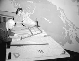
![A.R.P. first aid competition [at] Seaforth Armouries](/uploads/r/null/2/5/25929543d53336cd6b1cf824c48ad917349fb97f5482c26d1d63aa3cfe5b1667/1fbbcd48-c93f-4736-b82a-7bad8782339f-A06074_142.jpg)
A.R.P. first aid competition [at] Seaforth Armouries
Photograph shows a man judging a three-dimensional street map
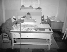
![A.R.P. first aid competition [at] Seaforth Armouries](/uploads/r/null/6/e/6e91a813d6246d4ca0c595c4378757f0dd9d6d400ad607b0659456e0055f058b/687d06fb-f08d-4b06-92e5-96796af8da2d-A06085_142.jpg)
A.R.P. first aid competition [at] Seaforth Armouries
Photograph shows a three-dimensional street map

Photograph shows a local areas (communities) map
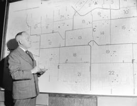
Photograph shows a man in front of a local areas (communities) map

![BC [British Columbia] postcard - The Rockies to the Pacific](/uploads/r/null/1/2/1226936/e2a6b4cf-7e7e-48c3-8e3b-6a150d917129-MI-342_142.jpg)
BC [British Columbia] postcard - The Rockies to the Pacific
Part of Yaletown Productions Inc. fonds
Film is a promotional video for the province of British Columbia. Focusing on different sections of the province in turn the video highlights the features and tourist attractions of each. According to the donor this is most likely the original of the final production with sound and image. Director Mike [Michael] Collier; cinematography Norm Keziere, Dave Geddes, Bob Asgeirsson, Bill Rounds, Tommy Tompkins, and John Anderson; editor Rober Brandreth-Gibbs; research Sharon McGowan; narration script Don White and Sharon McGowan, narrator Art Hives; video services Post Haste Video; film lab Alpha Cine Services; sound mix Pinewood Studios; special thanks to Tourism British Columbia. Produced by Yaletown Productions. b&w 00:10:57-00:11:04 and 00:18:47-00:19:22.
![Blueprint [of character of timber on Turnour Island]](/uploads/r/null/8/9/894a750e9e71be7f807c6e2e9eb4822b29b9fa8570e040790e258a7922284d91/5b6b1701-9ee0-4b21-bda9-1b7dd3435dfb-A18232_142.jpg)
Blueprint [of character of timber on Turnour Island]
Part of Stuart Thomson fonds
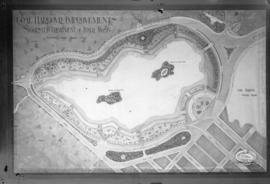
Coal Harbour Improvements Suggested Treatment of Inner Basin
Part of City of Vancouver fonds
Photograph shows map of suggested improvements.
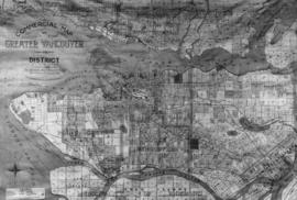
Commercial Map of Greater Vancouver and District
Part of Major Matthews collection
Item is a photograph of a map
![[Dining room in the"Taconite"- R.V.Y.C.]](/uploads/r/null/7/6/762c7be939adf73162e83d653eca06debab85ea65055518a55d96db60c6b7b22/487b20e5-c810-4e4f-92e0-81038f0de6e0-A17958_142.jpg)
[Dining room in the"Taconite"- R.V.Y.C.]
Part of Stuart Thomson fonds

False Creek reclamation. Suggested treatment in front of C.N.R. and Gt.N.R. passenger stations
Part of Major Matthews collection
Photograph negative is a copy of a plan produced by the City Engineer's Office, showing proposed streets and public garden area.
![General Worthington's visit to the Province Building [and the] C.P.R.](/uploads/r/null/1/c/1c8ff01aa559723da33198464d5cc5791a1a18b221c1123c1d0d2b4bf34f9e5c/aedd2864-dca2-42e9-b6e9-9b7141f79879-A06248_142.jpg)
General Worthington's visit to the Province Building [and the] C.P.R.
![Hudson Bay Company Army [recruitmant campaign] window display](/uploads/r/null/2/e/2e4a1deaea587cf23de896ea458f508ecb3c965c3efee4f81c576f323b4677f7/dc9e1c4b-6631-4219-b3bf-a894292c174f-A03719_142.jpg)
Hudson Bay Company Army [recruitmant campaign] window display

Landscape - bedding and borders : perennial garden planning plan
![Lipsett Museum [display] at the Vancouver Exhibition](/uploads/r/null/b/f/bf73df0a00efcd2138a7035f2f4222395db9ef1ae28d76d2f99c4e3dfa5b72fd/79d857dd-388a-48f5-a7bd-9d4b615fb1c6-A07340_142.jpg)
Lipsett Museum [display] at the Vancouver Exhibition
Photograph shows an ethnological map of British Columbia

Slide shows a world map of magnoliaceae distribution.
![[Map of Vancouver showing photographs of school buildings and their locations]](/uploads/r/null/5/2/8/5280488e1782e266d246f9ca56c073c54f56ff4bf3ccb72ba1081c606b7ad527/ede59cdc-62a0-4282-a668-c0edab9301e2-CVA371-2976_142.jpg)
[Map of Vancouver showing photographs of school buildings and their locations]
Part of Major Matthews collection
![Miscellaneous [65 of 130]](/uploads/r/null/d/9/d990a9299a9eeabca0e0be69e111fab9ae4394e8a51b1569141b348527334a00/7a1c7f8d-6bea-465a-ada0-9cd7dda26934-A64398_142.jpg)
Part of City of Vancouver fonds
![O'Brien Gourlay [promotion] "A Campaign is Born"](/uploads/r/null/9/8/98130411688b379e04be5033ae1c3ddbad844a4f46a55c81a59e6801bbaed929/f4b5c2b7-eb9d-4d97-93d1-dc90cd6599fd-A15170_142.jpg)
O'Brien Gourlay [promotion] "A Campaign is Born"
Photograph shows a man holding a Morrow Coal Company ad while examining a district map
![P.C.P.C. - A.R.P. interior [at 650 Burrard Street]](/uploads/r/null/5/0/50edd7a8dab34c27d1e6c30bd80fc58c12358971e65c352db2ec54a3cbbe9352/670be5e7-4616-494f-93dc-b7187ea66748-A05354_142.jpg)
P.C.P.C. - A.R.P. interior [at 650 Burrard Street]
Photograph shows the Provincial Civilian Protection Committee building

Pictorial Map of British Columbia, The Mineral Empire
Part of Major Matthews collection
Item is a photograph of a map

Plan of Burrard Peninsula - distribution of population estimated for 1950
Part of Major Matthews collection
Photograph negative is a copy of a map showing estimated population levels for Vancouver, Point Grey, South Vancouver and Burnaby. J.S. Matthews' notes with print or negative in Archives.

Plan of highway paralleling V.V. and E. Railway through D.L. 264A. City of Vancouver, B.C.
Part of Major Matthews collection
Photograph negative is a copy of a plan produced by the City Engineering Office, showing proposed location of road.
Plan of Vancouver, 1889 [fire map]
Part of Major Matthews collection
Item is a 1936 black and white reproduction of the 1889 Dakin fire insurance map. Item contains a legend and key plan. Map shows city block numbers, subdivision lot numbers, water pipes, sewer pipes, street names, and buildings.
![[Relief map of Vancouver and vicinity from A.R.P. headquarters]](/uploads/r/null/e/b/eb9fabcd34f3b0fb46820e6cb57b08f5b96f8a280edb5d316e0da81fcc9cbd68/442da9a4-6ef8-4eb2-8a41-40bb550e77ee-A11108_142.jpg)
[Relief map of Vancouver and vicinity from A.R.P. headquarters]

Vancouver and suburbs trolley and feeder map
Part of Major Matthews collection
Photograph is a copy of a map showing overhead trolley and railway feeder circuit locations in Vancouver and surrounding areas.

Vancouver and suburbs trolley and feeder map
Part of Major Matthews collection
Photograph negative is a copy of a map showing overhead trolley and railway feeder circuit locations in Vancouver and surrounding areas.

V.E. Day - P.C.P.C. Headquarters
Group portrait showing Provincial Civilian Protection Committee members

World distribution map- rhododendron