Title and statement of responsibility area
Title proper
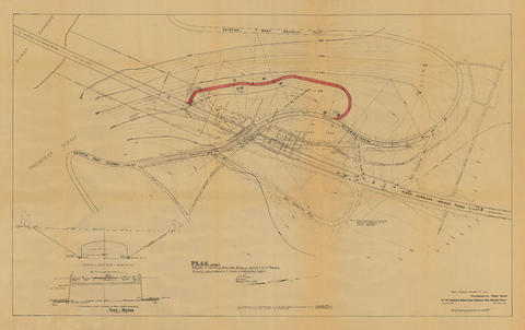
Plan (in red) showing a suggested bye-pass [sic] road at south end of bridge to avoid cars making a U-turn and obstructing traffic
General material designation
- Cartographic material
- Technical drawing
Parallel title
Other title information
Title statements of responsibility
Title notes
- Parallel titles and other title information: Base map title: Diversion of Park Road at 1st Narrows Bridge Road crossing near Prospect Point
Level of description
Item
Reference code
VPK-S81-: LEG1364.01
Edition area
Edition statement
Edition statement of responsibility
Class of material specific details area
Statement of scale (cartographic)
Statement of projection (cartographic)
Statement of coordinates (cartographic)
Statement of scale (architectural)
Issuing jurisdiction and denomination (philatelic)
Dates of creation area
Date(s)
-
Mar. 18, 1937-Jan. 17, 1939 (Creation)
- Note
- Base map prepared by First Narrows Bridge Co. Ltd., Mar. 18, 1937
Physical description area
Physical description
1 map and 2 technical drawings on 1 sheet : diazotype, annot. ; 76 x 121 cm
Publisher's series area
Title proper of publisher's series
Parallel titles of publisher's series
Other title information of publisher's series
Statement of responsibility relating to publisher's series
Numbering within publisher's series
Note on publisher's series
Archival description area
Name of creator
Custodial history
Scope and content
Item is a map of the Prospect Point area annotated to show a suggested bypass road at the south end of the First Narrows Bridge. Base map shows roadways approaching the proposed First Narrows Bridge, locations of hydrants, topography, and details of landscaping in some areas, and includes two elevations of a proposed skew bridge.
Notes area
Physical condition
Immediate source of acquisition
Arrangement
Language of material
Script of material
Location of originals
Availability of other formats
A digital copy is available.
Restrictions on access
Terms governing use, reproduction, and publication
Finding aids
Associated materials
Accruals
Rights
Public domain
External Link
ftp://webftp.vancouver.ca/archives/MAPS-TIFF/LEG1364.01.tif
- Format: TIFF (LZW compressed)
- MD5: D71FAAE3FCBC700A14BF353EA0919DEB
- Size: 119324096 bytes

