
Fraser River at Lillooet, B.C.
- AM54-S4-: Out P737.1
- Item
- [ca. 1950]
Part of Major Matthews collection
Photograph shows Mount Chadwick
10 results directly related Exclude narrower terms
Fraser River at Lillooet, B.C.
Part of Major Matthews collection
Photograph shows Mount Chadwick

Hydro electric surveys. Plan showing location of water powers investigated by City of Vancouver
Part of City of Vancouver fonds
Item is a map which shows the locations and the dates of use of "gauging stations established" and "city gauging stations still in use" in the area of south-western British Columbia where the City of Vancouver conducted hydro-electric surveys up to 1923.

Hydro electric surveys. Plan showing location of water powers investigated by City of Vancouver
Part of City of Vancouver fonds
Item is a map which functions as a visual index to the locations of various hydro electric surveys carried out by the City of Vancouver along the following rivers: Squamish River, Cheakamus River, Green River, Lillooet River, Eagle River, Indian River, Pitt River, Chehalis River, Harrison River, Chilliwack River, the Fraser and Thompson Rivers, and Bridge River. The map lists the names of the surveyors responsible and the areas covered by each survey. Annotations include the locations and the dates of use of "gauging stations established" and "city gauging stations still in use."
Part of A.W. Phair fonds


Part of William Orson Banfield fonds
![The gorge of the Fraser above Lilloett [Lillooet]](/uploads/r/null/8/b/b/8bbb997dadba447dad3825e5407df74621e512bfefbe0b82192612896ac7aeda/7f9a3be1-250e-4ac2-8635-69cb36c24c04-CVA289-004_142.jpg)
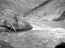
The gorge of the Fraser above Lilloett [Lillooet]
Part of William Orson Banfield fonds
![[The Howe truss bridge]](/uploads/r/null/4/c/4c4775923ef2f5c6691e5190b954de97096b0f4569d121a31624b5a281a341d7/f4964437-02ca-429b-a8ea-db523d77a0f5-A33606_142.jpg)
Part of Major Matthews collection
Photograph shows Mount Chadwick on the left
![[View of Cayoosh Creek and Ample Mountain]](/uploads/r/null/e/a/ea75682f162bb2aedea1b09fbb0a8cf71d5a95c2056dfbf9e983ac18299f710a/e9af0c82-8fe7-4f81-a319-7c677ee1eeb0-A33608_142.jpg)
[View of Cayoosh Creek and Ample Mountain]
Part of Major Matthews collection
Photograph shows John Dunlap's store
![[View of Lillooet]](/uploads/r/null/5/0/50f146e9e439fcd3bf14d29759d31dd388474f6b6499911ed7cf6bf60240d3fc/0597e9d1-1aaf-4e27-85a7-e55da6328188-A33598_142.jpg)
Part of Major Matthews collection