
- AM127-: MAP 648
- Item
- Jan. 30, 1893
Item is a map showing land subdivision in downtown Vancouver around Burrard Inlet, and the route of the Canadian pacific Railway along the south shore of Burrard Inlet.
289 results directly related Exclude narrower terms
Item is a map showing land subdivision in downtown Vancouver around Burrard Inlet, and the route of the Canadian pacific Railway along the south shore of Burrard Inlet.
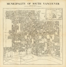
Municipality of South Vancouver
Part of McGuigan family fonds
Item is a map showing legal addresses in South Vancouver. An inset map shows the Municipality of South Vancouver in relation to the rest of the Greater Vancouver area.

Part of City of Vancouver Archives technical and cartographic drawing collection
Item is a reduced size copy of the Hermon & Burwell map Plan of the City of Vancouver. This copy is ca. 1/4 the size of the original map. The map shows District Lots, blocks and lots; transportation infrastructure such as bridges and railway and streetcar lines; and the identification of some industries, especially along the various waterfronts.
![Canadian Pacific map of Vancouver [west half]](/uploads/r/null/f/a/fa49266d21715d75ce93883012d471657dd058b90843927ec82b44d2bb42b007/f12ea9a5-4914-4db8-bda9-312aa2e2ccef-MAP10_142.jpg)
Canadian Pacific map of Vancouver [west half]
Part of City of Vancouver Archives technical and cartographic drawing collection
Item is a portion of a map depicting lands granted to the Canadian Pacific Railway in Vancouver. The portion depicts the West End and northern Kitsilano.
Part of City of Vancouver Archives technical and cartographic drawing collection
Item is a map showing the location of City-owned properties around the perimeter of the western half of False Creek, west of the Connaught Bridge (Cambie Street Bridge) as of Nov. 1969. City-owned lots are outlined in coloured pencil. Notations are also included on land usage, ownership and land transfers os some south shore properties not owned by the City.
Annotations have been made on a part of a copy of a base map originally created to show land transfers between the C.P.R and the Government of British Columbia.
Vancouver (B.C.). Properties Division

Plan of district lots 264, 265, 266 and 552, North Vancouver, British Columbia
Part of City of Vancouver Archives technical and cartographic drawing collection
Item is a map showing lot numbers and lot boundaries in the area from Phillips Avenue to Bewicke Avenue and Twenty-third Street to Burrard Inlet. An index map shows the location of the primary map in relation to the rest of Greater Vancouver.
Vancouver 1886-1986 : yesterday, gateway to the Pacific : today, crossroads of the world
Part of City of Vancouver Archives technical and cartographic drawing collection
Map is a souvenir poster reproduced from an original in the National Map Collection, Public Archives of Canada. The map shows lot numbers and lot boundaries for the city of Vancouver as of June 1886. The original map was entitled "Plan of the city of Vancouver, Western Terminus of the Canadian Pacific Railway".

Second section : Shaughnessy Heights
Part of City of Vancouver Archives technical and cartographic drawing collection
Item is a map showing lot subdivision of the southern portion of Shaughnessy Heights (commonly referred to as "Second Shaughnessy") at January 1st, 1932. Annotations appear to refer to zoning restrictions.
Canadian Pacific Railway Company
City of Vancouver : Canadian Pacific town site
Part of City of Vancouver Archives technical and cartographic drawing collection
Primary map shows lot numbers and boundaries, streets, fire limits and "soundings in feet" (in English Bay, Burrard Inlet, Coal Harbour and False Creek) in downtown Vancouver, Stanley Park and parts of Kitsilano and Fairview. The ancillary maps show an "Index plan of Vancouver, B.C.", an "Index plan of [Vancouver] city limits" and "Canadian Pacific Mail Steamship Lines" (a map of Canadian Pacifc steamship routes around the world). On recto, the item also includes a description of Stanley Park and an illustration of Vancouver's inner harbour. On verso, the item includes descriptions of major Vancouver residences, imports, exports, businesses and other landmarks.
![Map of the business portion of the City of Vancouver, British Columbia [early street paving]](/uploads/r/null/7/1/7187f671d2770050eb87f7f397a10ea92bf0bc593b0a186e3a4bf341b3d26e42/8770145a-b925-4eef-82ac-e397f61a65aa-Map1163_142.jpg)
Map of the business portion of the City of Vancouver, British Columbia [early street paving]
Part of City of Vancouver Archives technical and cartographic drawing collection
Item is a published map of the Vancouver central business district which has been annotated to show which paving type has been used on certain streets: wood block or bituminous.
Part of City of Vancouver Archives technical and cartographic drawing collection
Map shows lot numbers, lot boundaries and major roads in the municipality of Burnaby.

Map of New Westminster District, B.C.
Part of City of Vancouver Archives technical and cartographic drawing collection
Map shows lot numbers and municipal boundaries in the area from Pitt Lake in the north to the United States border in the south and from the municipality of Coquitlam in the east to Point Atkinson in the west.

Portions of New Westminster District and Vancouver Island
Part of City of Vancouver Archives technical and cartographic drawing collection
Item is an economic map which depicts the area of central Vancouver Island made up of the Comox, Nelson, and Newcastle land divisions, as well as portions of the Alberni, Cameron and Nanoose land district. The map includes the inside passage islands between Lasqueti and Sonora Islands, and the coastal portion of the New Westminster land district from Bute Inlet south to the mouth of the north arm of the Fraser River.
Information included on the map includes timber licenses, Indian reservations, other government reserves, District Lots, physical features (not including topography), and municipal boundaries.

Southerly portion. Vancouver Island
Part of City of Vancouver Archives technical and cartographic drawing collection
Item is an economic map which depicts Vancouver Island south of Buttle Lake, as well as coastal areas of the mainland from the approximate location of Britannia Beach, south and the northern coast of the Olympic Peninsula. Information included in the map include Timber Licenses, Indian reserves, other land reserves, municipal boundaries, District Lots outside municipalities, geographic features (not including topography), transportation routes, and parks.
Southerly portion of Vancouver Island
Part of City of Vancouver Archives technical and cartographic drawing collection
Item is a geographic and economic map of the southern half of Vancouver Island. The map shows parcels of land, including Crown land granted, timber leases and licences, Indian reserves, government reserves, and various political boundaries boundaries.
Map of portion of New Westminster District with adjacent islands and part of Vancouver Island, B.C.
Part of City of Vancouver Archives technical and cartographic drawing collection
Item is a map which shows parts of the east coast of Vancouver Island of southern Vancouver Island, the Strait of Georgia, the Gulf Islands, the Sechelt Peninsula, and Greater Vancouver. The map shows the numbers of the district lots for all of the New Westminster Land District.

Part of City of Vancouver Archives technical and cartographic drawing collection
Map shows a survey conducted by the Canadian Pacific Railway of English Bay, Burrard Inlet and Coal Harbour, including a rough outline of area and lots. Note on map reads "Certified as a correct plan showing the land required for right of way Burrard Inlet B.C., February 22, 1886. H.J. Cambie, Engineer in Charge." Map is certified as correct and signed by various C.P.R. officials, including W.C. Van Horne.
Indexed guide map of the City of Vancouver and suburbs
Part of City of Vancouver Archives technical and cartographic drawing collection
Item is a sheet with a map on the recto and text on the verso. The map shows District Lots in Vancouver, South Vancouver, Point Grey, Burnaby, Richmond, New Westminster, West Vancouver, and North Vancouver.
A composite plan showing Capilano Indian Reserve No. 5 and district lot 5521
Part of City of Vancouver Archives technical and cartographic drawing collection
Item is a map showing a portion of West Vancouver, including D.L. 5521 and the Capilano Indian Reserve No. 5. The annotations denote the location of Humiltschen Park.
West Vancouver (B.C.). Assessment Department
Map of portion of New Westminster District with adjacent islands and part of Vancouver Island
Part of City of Vancouver Archives technical and cartographic drawing collection
Item is a property map which shows timber leasesholds, Indian reserves, districts, and parcels of land.

Map of the south-western part of British Columbia
Part of City of Vancouver Archives technical and cartographic drawing collection
Item is a map which depicts the relative locations of various Land Districts and Divisions in south-west British Columbia. The boundaries between the districts are not shown. The map also shows physical features (though not topography) and transportation routes.
Plan of the City of Vancouver, British Columbia
Part of City of Vancouver Archives technical and cartographic drawing collection
Item is a map sheet with two maps of Vancouver. The main map shows District Lots, blocks and ranges of lot numbers, streets, railway lines, and boundaries in Vancouver. The inset map shows Stanley Park with rough depictions of topography.

Plan of the City of Vancouver, British Columbia
Part of City of Vancouver Archives technical and cartographic drawing collection
Item is a partial copy of a map of Vancouver, showing only the western portion of the pre-1929 city.

Plan of subdivision of part of D.L. 526 : South Vancouver
Part of City of Vancouver Archives technical and cartographic drawing collection
Item is a map denoting Canadian Pacific land in D.L. 526. The map shows blocks 581-584, 601-604, 621-624, 661-664, 681-684 bounded on the north by 20th Ave., south by McMullen Ave., east by Ontario Street, and west by Bridge Street.

Map of New Westminster District, B.C
Part of City of Vancouver Archives technical and cartographic drawing collection
Item is a map showing District Lots in Vancouver, and township/range designations in other areas. The map also shows False Creek Trail, North Arm Road, False Creek Road, Granville Road from Granville to Hastings, New Westminster and Burrard Inlet Road, North Road, Semiahmoo Road, New Westminster and Yale Wagon Road, and others. Annotated by W. E. Graveley, 1885, to show additional features including Kingsway, Haney, Albion Camp, etc.

Vancouver North. British Columbia
Part of City of Vancouver Archives technical and cartographic drawing collection
Item is a topographical map showing the eastern portion of Sechelt Peninsula, Keats Island, southern portion of Gambier Island, Bowen Island, West Vancouver, North Vancouver, and Vancouver. City streets and blocks are shown, as well as surveyed parcels of land. Map also shows depth contours in fathoms for Howe Sound and Burrard Inlet.

Part of City of Vancouver Archives technical and cartographic drawing collection
Item is a map depicting the "original plan" for District Lot 540, including the area bounded by Trafalgar Street to English bay to Campbell Street to 16th Avenue. Block numbers and the location of public parks are noted.
Vancouver (B.C.). Engineer's Office

Plan of Provincial Government property being a portion of Townsite of Vancouver
Part of City of Vancouver Archives technical and cartographic drawing collection

Plan of part of subdivision of district lot 540. South Vancouver
Part of City of Vancouver Archives technical and cartographic drawing collection
Item is a map showing provincially-owned properties for sale in District Lot 540, South Vancouver, B.C.

City of Vancouver : Canadian Pacific town site
Part of City of Vancouver Archives technical and cartographic drawing collection
Part contains four maps. The main map shows district lots and block numbers in Vancouver from Vine Street in the west to Boundary Avenue (Glen Drive) in the east and Stanley Park in the north to 9th Avenue (Broadway) in the south. Three smaller maps include an index plan to district lots in Vancouver, South Vancouver, New Westminster, and Burnaby; a world map showing Canadian Pacific mail steamship lines; and an index plan of Vancouver city limits.

Part of City of Vancouver Archives technical and cartographic drawing collection
Item is a tracing of a map. The tracing shows city blocks, tramways, and railways in Vancouver. The map includes three illustrations, entitled: A glimpse of Cordova Street; In Stanley Park; View of city from Fairview.
Stuart, Allan K.

Part of City of Vancouver Archives technical and cartographic drawing collection
Item is a map showing land subdivision in the New Westminster District. The Reference index indicates that lands alienated or covered by applications under the "Land Act"; surveyed timber leases, licences, and births; and Indian reserves are noted; none of these categories of land have been colour-coded on the map. The map also shows land district boundaries; park boundaries; provincial forest boundaries; forest management licences; and municipal boundaries.
The map appears to be based on the National Topographic Series 1:250,000 map 92G, with other data added.

Part of City of Vancouver Archives technical and cartographic drawing collection
Item is a map showing land subdivision in the New Westminster District. The map shows lands alienated or covered by applications under the "Land Act"; surveyed timber leases, licences, and births; and Indian reserves; shows land district boundaries; park boundaries; provincial forest boundaries; forest management licences; and municipal boundaries.
The map appears to be based on the National Topographic Series 1:250,000 map 92G, with other data added.

Part of City of Vancouver Archives technical and cartographic drawing collection
Item is a map showing New Westminster Land District, including lands alienated or covered by application under the Land Act; surveyed timber leases, licences, or berths; Indian reserves; Government reserves; provincial forest boundaries; tree farm licences; municipality boundaries; and park boundaries. Includes a key plan of maps published in the same publisher's series and a reliability diagram noting data sources.
Part of City of Vancouver Archives technical and cartographic drawing collection
Item is a pamphlet with a map of the Lower Mainland on one side and information about Delta, Chilliwhack [sic], Surrey, New Westminster, Maple Ridge, Langley, and British Columbia on the other.
Map of West Vancouver and vicinity
Part of City of Vancouver Archives technical and cartographic drawing collection
Item is a map of West Vancouver, North Vancouver, and the northern parts of Vancouver and Burnaby, with an advertisement for R.P. Matheson Advertising Service and promotional images of West Vancouver on verso. Item appears to have been cut from a larger publication; some images on verso are cut off.

Map of West Vancouver and vicinity
Part of City of Vancouver Archives technical and cartographic drawing collection
Part contains a map of West Vancouver, North Vancouver, and the northern parts of Vancouver and Burnaby. Map shows district lot and block numbers, streets, and distances from City Hall.

Plan of West Vancouver Municipality
Part of City of Vancouver Archives technical and cartographic drawing collection
Item is a map showing land subdivisions in West Vancouver, and annotated by J. S. Matthews with historic names and locations. A small key map shows the location covered by the primary map in relation to the rest of the Lower Mainland.
Part of City of Vancouver Archives technical and cartographic drawing collection
Item is a map showing land subdivisions for West Vancouver, streets, and railway routes.

City of Vancouver : Canadian Pacific town site
Part of City of Vancouver Archives technical and cartographic drawing collection
Part contains four maps. The main map shows district lots and block numbers in Vancouver from Vine Street in the west to Boundary Avenue (Glen Drive) in the east and Stanley Park in the north to 9th Avenue (Broadway) in the south. Three smaller maps include an index plan to district lots in Vancouver, South Vancouver, New Westminster, and Burnaby; a world map showing Canadian Pacific mail steamship lines; and an index plan of Vancouver city limits. Part has been annotated with text describing a June 1888 land clearance plan and hand colouring indicating clearance status.

Part of City of Vancouver Archives technical and cartographic drawing collection

Port Moody, the western terminus of the Canadian Pacific Railway
Part of City of Vancouver Archives technical and cartographic drawing collection
Item is a map showing lots surveys and made available for purchase in Port Moody.
![[First section of] Shaughnessy Heights](/uploads/r/null/c/d/0/cd05f96b7e9f01fee4ba2afe83ac83cef9d70b3cf83d3ba8c4ebe5a0a20a429d/0d2ec941-063b-4722-8d84-aff283b273f6-MAP329_142.jpg)
[First section of] Shaughnessy Heights
Part of City of Vancouver Archives technical and cartographic drawing collection
Item is a cadastral map showing lot divisions and in some cases ownership, in Shaughnessy Heights up to January 1st, 1932.
Canadian Pacific Railway Company
![[Second section of] Shaughnessy Heights](/uploads/r/null/9/4/d/94d42178bb60a8c60cdc002199430e863ae830696947ad73807b5fd11046c39a/72c651d3-6742-4c5c-a0bc-d83c3526a9ba-MAP330_142.jpg)
[Second section of] Shaughnessy Heights
Part of City of Vancouver Archives technical and cartographic drawing collection
Item is a map showing lot subdivision of the southern portion of Shaughnessy Heights (commonly referred to as "Second Shaughnessy") at January 1st, 1932.
Canadian Pacific Railway Company
![[Third section of] Shaughnessy Heights](/uploads/r/null/b/9/c/b9c97036cadac8b6ffc53f2380c1c158d767da3473d29ad1b04968cc742d132e/0301116d-9946-489d-a272-9d6453523103-MAP331_142.jpg)
[Third section of] Shaughnessy Heights
Part of City of Vancouver Archives technical and cartographic drawing collection
Item is a map showing lot subdivisions in the portion of Shaughnessy Heights south of Thirty-seventh Avenue as of January 1st, 1931.
![D.L. [District Lot] 526](/uploads/r/null/c/b/4/cb45fc2541156cf0f1c89b637733e961198017ddd4aa199ba866f1150856a8ba/dfb19024-a115-4097-9258-559e228c275d-MAP332_142.jpg)
Part of City of Vancouver Archives technical and cartographic drawing collection
Item is a portion of a map showing first, second, and third sections of Shaughnessy Heights. Annotations are red lines denoting each of the three stages of Shaughnessy development.

Part of City of Vancouver Archives technical and cartographic drawing collection
Item is a map showing lots for sale in the Grandview District.

Plan of government subdivision at Point Grey, B.C.
Part of City of Vancouver Archives technical and cartographic drawing collection
Item is a sheet which has been excised from the Journal of the Town Planning Institute, December 1925 issue. The sheet consists of two street layout plans and an illustration. The street layout plans show current and proposed revised street layouts for the area of Point Grey bounded by Highbury Street, Eighth Avenue, Imperial Street, and Tenth Avenue. The illustration depicts the view north from the proposed development area.
![Plan of Point Grey Municipality [ward boundaries]](/uploads/r/null/a/c/a/aca691b3d6e49d092070fc230a88f5ca7bd346fc8c5894892d7cdc5a79b535ee/9a14b192-1858-43aa-ab28-d0b03a2304eb-MAP360_142.jpg)
Plan of Point Grey Municipality [ward boundaries]
Part of City of Vancouver Archives technical and cartographic drawing collection
Item is a copy of a commercially published map of Point Grey which has been used as a base map to depict existing and proposed new ward boundaries for Point Grey municipality.

Part of D.L. 526 (Vancouver section 29)
Part of City of Vancouver Archives technical and cartographic drawing collection
Item is a sectional plan which shows the area of Kitsilano Point and the adjacent area of Kitsilano south to 1st Avenue in the south and Arbutus Street to the west. The map includes the CPR right of way and harbour headlines, as well as the Vancouver and Lulu Island railway (CPR).