Land subdivision--Vancouver (B.C.)

Taxonomy

Code

Scope note(s)

Source note(s)

Display note(s)

Hierarchical terms

Land subdivision--Vancouver (B.C.)

Equivalent terms

Land subdivision--Vancouver (B.C.)

Associated terms

Land subdivision--Vancouver (B.C.)

383 Archival description results for Land subdivision--Vancouver (B.C.)

383 results directly related Exclude narrower terms

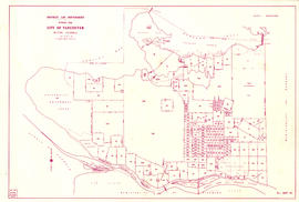
City of Vancouver : showing all city owned property [sectional map]

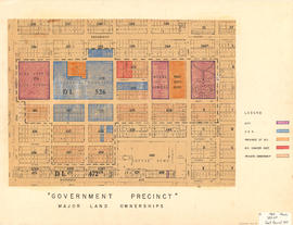
File consists of three maps, including one sectional maps. The maps include an index to the sections, an index to District Lots, and one sectional map in 61 sections. The sections have been annotated with colour coding to show tax sale property for sale, property with no water, street widening and drainage, replotting, reserved land for schools, reserved land for parks, sundry land, capital assets not including schools and parks, schools, and parks. An index to the colour coding was hand-drawn on the verso of the sheet with the index to District Lots.

Vancouver (B.C.). Office of the City Engineer

City of Vancouver, British Columbia [index map]

Item is an index map of Vancouver showing the boundaries of the sectional maps in this file. Map includes streets, roads and railways; blocks, lots and legal descriptions; First Nations reserves, government buildings, cemeteries, parks and businesses along the waterfront.

Vancouver (B.C.). Office of the City Engineer

City of Vancouver, British Columbia [sectional map]

File consists of three maps of Vancouver: an index map to the sections, an index map to District Lots, and 62 section sheets drawn and revised between ca. 1935 and 1945. Some time between 1946 and 1951 these maps were compiled and reproduced by the City Engineer's Office.

The 62 sectional plates are divided into three groups: the "Old City of Vancouver," Point Grey and South Vancouver. Maps show streets and roads, blocks, lots, legal descriptions, railways, parks, schools, hospital, cemetery, golf courses, retirement homes, and some businesses.

Vancouver (B.C.). Office of the City Engineer

City of Vancouver, Vancouver, British Columbia : sectional maps

File consists of three maps of Vancouver: an index to the sectional map sheets, a plan of District Lots in Vancouver, and a sectional map in 62 sheets. The sectional map sheets show streets and roads, blocks, lots, legal descriptions, railways, parks, schools, hospital, cemetery, golf courses, retirement homes, and some businesses.

Vancouver (B.C.). Office of the City Engineer

City of Vancouver, Vancouver, British Columbia : sectional maps (printed 1970)

File consists of two index maps and eighty-five sectional maps of Vancouver, revised between 1965 and 1970. Sectional maps include streets, blocks, lots, legal descriptions, railways, parks, schools, hospitals, cemetery, golf courses, retirement homes, public buildings, First Nations reserves and some businesses. Maps were compiled by the City Engineer's Office and supplied by the Property and Insurance Office of the City of Vancouver. Maps for sections 68 and 91 were not available at the time of issue.

Corporation of Point Grey : topographical plan of ABCDE D.L. 317 and HIJK D.L. 318 : Marine Drive & Vancouver & Lulu Railway to Fraser River between Angus St. [Drive] & Milton St

Item is a topographical plan of Point Grey showing the area from Angus Drive to Granville Street and 71st Avenue to the Fraser River, including property in D.L. 317 and D.L. 318. Plan shows the locations of the Vancouver and Lulu Island Railway, as well as ponds, dams, barns, houses and offices.

Government precinct : major land ownerships

Map is a plan of the area bounded by Oak Street, Broadway, Yukon Street and Sixteenth Avenue, showing streets, blocks, lots and legal descriptions. Map is hand coloured to show property owned by the City, Vancouver General Hospital, the Province of British Columbia, the B.C. Cancer Institute, and private owners within the 'Government Precinct' boundaries. Indicated are the locations of King Edward High School, Vancouver General Hospital, the Model School, Provincial Government building, City Hall, and a Refuge Home. Plan is labelled "G : 1960 March, 320-6A, Gov't Precinct 1957."

Map of City of Vancouver, British Columbia [index map]

Item is an index map of Vancouver showing the boundaries of the sections of the sectional map in this file. Sections depict streets and railway lines; District Lots, blocks, and lots; First Nations reserves, golf courses, cemeteries, parks and businesses along the Burrard Inlet waterfront.

Vancouver (B.C.). Office of the City Engineer

Map of City of Vancouver, British Columbia [index map]

Item is an index map of Vancouver showing the boundaries of the sectional maps in this file. Map includes streets, roads and railways; blocks, lots and legal descriptions; First Nations reserves, golf courses, cemeteries, parks and businesses along the Burrard Inlet waterfront.

Vancouver (B.C.). Office of the City Engineer

Map of portion New Westminster District

Item is a heavily-amended copy of a map illustrating intended land settlement and subdivision in 1877 in the future sites of Vancouver, Burnaby and the North Shore, from an area bordering on English Bay to an area bordering on North Arm. Also shown are bodies of water, Hastings & Granville Road, and the settlements of Hastings and Granville. Annotations by J.S. Matthews in 1954 made on the copy are tracings in white pen and darkening the background to improve the copy.

Map of portion New Westminster District

Item is an annotated tracing of a map showing the future sites of Vancouver, Burnaby and the North Shore from an area bordering on English Bay to an area bordering on North Arm. Traced over by J.S. Matthews in 1954, it illustrates intended land settlement and subdivision in 1877. Also shown are bodies of water, Hastings & Granville Road, and the settlements of Hastings and Granville. Annotations are an introductory note by Matthews in August 1954 titled "Before Greater Vancouver." Enclosed with the map are four letters between J.S. Matthews and W.H. Hutchinson, Chief of the Geographic Division of the B.C. Survey and Mapping Branch of the Department of Lands and Forests, in 1954 concerning the map's provenance and Matthew's efforts to increase the legibility of copies of the original map.

Plan of district lot boundaries, City of Vancouver, B.C.

Item is a map of Vancouver showing district lot boundaries.

The map identifies First Nations reserves, the University Endowment Lands, Stanley Park, Old Granville Townsite and Hastings Townsite. On the verso of the map is a legend indicating the colours used on the maps in this file to define areas of tax sale property for sale, no water, street widening - drainage, replotting, reserved school, reserved park, sundry, capital assets (except schools and parks), schools, and parks.

Vancouver (B.C.). Office of the City Engineer

Plan of Hastings

Map is a negative photostatic copy of a plan of lots offered for auction in Hastings on 10th July 1869, indicating which lots were sold and which lots were reserved. Plan also shows the locations of government buildings, a church, a hospital, Oliver M. Hocking's house and stable, the road from New Westminster to Burrard Inlet, Mae N. (Broughton), and [bearing] to Moody's Mill. This map does not include the typed note by J.S. Matthews, 1933, titled "First Sale of Lots, 1869 (City of Vancouver), Hocking's." The map was certified by Robert Beaver, C.C.L&W, as a true copy from the map in the Lands and Works Office, 21st June 1873. Also included with the map are drafts of the text by Major Matthews.

Plan of Hastings

Map is a photostatic copy of a plan of lots offered for auction in Hastings on 10th July, 1869, indicating which lots were sold and which lots were reserved. Plan also shows the locations of government buildings, a church, a hospital, Oliver M. Hocking's house and stable, the road from New Westminster to Burrard Inlet, Mae N. (Broughton), and [bearing] to Moody's Mill. Includes a note by J.S. Matthews, 1933, titled "First Sale of Lots, 1869 (City of Vancouver), Hocking's." The map was certified by Robert Beaver, C.C.L&W, as a true copy from the map in the Lands and Works Office, 21st June 1873. Also included with the map are drafts of the text by Major Matthews.

Plan of Hastings

Map is a negative photostatic copy of a plan of lots offered for auction in Hastings on 10th July 1869, indicating which lots were sold and which lots were reserved. Plan also shows the locations of government buildings, a church, a hospital, Oliver M. Hocking's house and stable, the road from New Westminster to Burrard Inlet, Mae N. (Broughton), and [bearing] to Moody's Mill. Includes a note by J.S. Matthews, 1933, titled "First Sale of Lots, 1869 (City of Vancouver), Hocking's." The original map was certified by Robert Beaver, C.C.L&W, as a true copy from the map in the Lands and Works Office, 21st June 1873. Also included with the map are drafts of the text by Major Matthews.

Plan of Hastings

Map is a photostatic copy of a plan of lots offered for auction in Hastings on 10th July 1869, indicating which lots were sold and which lots were reserved. Plan also shows the locations of government buildings, a church, a hospital, Oliver M. Hocking's house and stable, the road from New Westminster to Burrard Inlet, Mae N. (Broughton), and [bearing] to Moody's Mill. This map does not include the typed note by J.S. Matthews, 1933, titled "First Sale of Lots, 1869 (City of Vancouver), Hocking's." The map was certified by Robert Beaver, C.C.L&W, as a true copy from the map in the Lands and Works Office, 21st June 1873. Also included with the map are drafts of the text by Major Matthews.

Plan of Hastings

Map is a plan of lots offered for auction in Hastings on 10th July 1869, indicating which lots were sold and which lots were reserved. Plan also shows the locations of government buildings, a church, a hospital, Oliver M. Hocking's house and stable, the road from New Westminster to Burrard Inlet, Mae N. (Broughton), and [bearing] to Moody's Mill. Pasted onto the front of the map is a typed note by J.S. Matthews, 1933, titled "First Sale of Lots, 1869 (City of Vancouver), Hocking's." The map was certified by Robert Beaver, C.C.L&W, as a true copy from the map in the Lands and Works Office, 21st June 1873. Also included with the map are drafts of the text by Major Matthews.

Plan of Hastings

Map is a photostatic copy of MAP 1037.01, showing a plan of lots offered for auction in Hastings on 10th July 1869 and indicating which lots were sold and which lots were reserved. Plan also shows the locations of government buildings, a church, a hospital, Oliver M. Hocking's house and stable, the road from New Westminster to Burrard Inlet, Mae N. (Broughton), and [bearing] to Moody's Mill. This map does not include the typed note by J.S. Matthews, 1933, titled "First Sale of Lots, 1869 (City of Vancouver), Hocking's." The map was certified by Robert Beaver, C.C.L&W, as a true copy from the map in the Lands and Works Office, 21st June 1873. Also included with the map are drafts of the text by Major Matthews.

Sheet 1 : Cambie Street to Carolina Street and Sixteenth Avenue to Twenty-eighth Avenue

Item is a section showing the area from Cambie Street to Carolina Street and Sixteenth Avenue to Twenty-eighth Avenue. Includes streets, roads, blocks, lots, legal descriptions, parks, nurseries and schools. Map is hand coloured to show tax sale property for sale, property with no water, street widening and drainage, replotting, reserved land for schools, reserved land for parks, sundry land, capital assets not including schools and parks, schools, and parks, as applicable.

Vancouver (B.C.). Office of the City Engineer

Sheet 1 : Slocan Street to Boundary Road and Triumph Street to Burrard Inlet

Item is a section showing the area bound by Slocan Street, Boundary Road, Triumph Street and the waterfront. Includes streets, roads, railways, blocks, lots, legal descriptions, quit claims, leases, parks and businesses along the waterfront.

Vancouver (B.C.). Office of the City Engineer

Sheet 1 : Slocan Street to Boundary Road and Triumph Street to Burrard Inlet

Item is a section showing the area bound by Slocan Street, Boundary Road, Triumph Street and the waterfront. Includes streets, roads, railways, blocks, lots, legal descriptions, quit claims, leases, parks and businesses along the waterfront. Section is annotated in colour to show tax sale property for sale, property with no water, street widening and drainage, replotting, reserved land for schools, reserved land for parks, sundry land, capital assets not including schools and parks, schools, and parks, as applicable.

Vancouver (B.C.). Office of the City Engineer

Sheet 1: Slocan Street to Boundary Road and Triumph Street to Burrard Inlet

Item is a section showing the area bound by Slocan Street, Boundary Road, Triumph Street and the waterfront. Includes streets, roads, railways, blocks, lots, legal descriptions, quit claims, leases, parks and businesses along the waterfront.

Vancouver (B.C.). Office of the City Engineer

Sheet 10 : Clark Drive to Nanaimo Street and Frances Street to Burrard Inlet

Item is a section showing the area from Clark Drive to Nanaimo Street and Frances Street to Burrard Inlet. Includes streets, blocks, lots and legal descriptions, and the locations of parks and a juvenile detention home.

Vancouver (B.C.). Engineering Services

Sheet 10 : Clark Drive to Slocan Street and Burrard Inlet to Triumph Street

Item is a section showing the area from Clark Drive to Slocan Street and aterfront to Triumph Street. Includes streets and roads, blocks, lots, legal descriptions, railways, parks, boys' detention home and businesses along the waterfront. The Town of Hastings is indicated on the map. Map is hand coloured to show tax sale property for sale, property with no water, street widening and drainage, replotting, reserved land for schools, reserved land for parks, sundry land, capital assets not including schools and parks, schools, and parks, as applicable.

Vancouver (B.C.). Office of the City Engineer

Sheet 10 : Clark Drive to Slocan Street and waterfront to Triumph Street

Item is a section showing the area from Clark Drive to Slocan Street and aterfront to Triumph Street. Includes streets and roads, blocks, lots, legal descriptions, railways, parks, boys' detention home and businesses along the waterfront. The Town of Hastings is indicated on the map.

Vancouver (B.C.). Office of the City Engineer

Sheet 10 : Clark Drive to Slocan Street and waterfront to Triumph Street

Item is a section showing the area from Clark Drive to Slocan Street and waterfront to Triumph Street. Includes streets and roads, blocks, lots, legal descriptions, railways, parks, boys' detention home and businesses along the waterfront. The Town of Hastings is indicated on the map.

Vancouver (B.C.). Office of the City Engineer

Sheet 10 : Earles Street to Boundary Road and Fortieth Avenue to Fiftieth Avenue

Item is a section showing the area from Carlton Street to Boundary Road and Fortieth Avenue to Fiftieth Avenue. Includes streets, roads, blocks, lots, legal descriptions, parks and schools. Map is hand coloured to show tax sale property for sale, property with no water, street widening and drainage, replotting, reserved land for schools, reserved land for parks, sundry land, capital assets not including schools and parks, schools, and parks, as applicable.

Vancouver (B.C.). Office of the City Engineer

Sheet 11 : Cambie Street to St. George Street and Forty-seventh Avenue to Fifty-eighth Avenue

Item is a section showing the area from Cambie Street to St. George Street and Forty-seventh Avenue to Fifty-eighth Avenue. Includes streets, roads, blocks, lots, legal descriptions, golf courses, parks and schools. Map is hand coloured to show tax sale property for sale, property with no water, street widening and drainage, replotting, reserved land for schools, reserved land for parks, sundry land, capital assets not including schools and parks, schools, and parks, as applicable.

Vancouver (B.C.). Office of the City Engineer

Sheet 11 : Carrall Street to Clark Drive and waterfront to Keefer Street

Item is a section showing the area from Carrall Street to Clark Drive and waterfront to Keefer Street. Includes streets and roads, blocks, lots, legal descriptions, railways, parks, schools, freight sheds, warehouses, piers and businesses along the waterfront.

Vancouver (B.C.). Office of the City Engineer

Sheet 11 : Carrall Street to Clark Drive and waterfront to Keefer Street

Item is a section showing the area from Carrall Street to Clark Drive and waterfront to Keefer Street. Includes streets and roads, blocks, lots, legal descriptions, railways, parks, schools, freight sheds, warehouses, piers and businesses along the waterfront.Map is hand coloured to show tax sale property for sale, property with no water, street widening and drainage, replotting, reserved land for schools, reserved land for parks, sundry land, capital assets not including schools and parks, schools, and parks, as applicable.

Vancouver (B.C.). Office of the City Engineer

Sheet 11 : Carrall Street to Clark Drive and waterfront to Keefer Street

Item is a section showing the area from Carrall Street to Clark Drive and waterfront to Keefer Street. Includes streets and roads, blocks, lots, legal descriptions, railways, parks, schools, freight sheds, warehouses, piers and businesses along the waterfront.

Vancouver (B.C.). Office of the City Engineer

Sheet 12 : Prince Edward Street to Bruce Street and Forty-seventh Avenue to Fifty-eighth Avenue

Item is a section showing the area from Prince Edward Street to Bruce Street and Forty-seventh Avenue to Fifty-eighth Avenue. Includes streets, roads, blocks, lots, legal descriptions, parks and schools. Map is hand coloured to show tax sale property for sale, property with no water, street widening and drainage, replotting, reserved land for schools, reserved land for parks, sundry land, capital assets not including schools and parks, schools, and parks, as applicable.

Vancouver (B.C.). Office of the City Engineer

Sheet 12 : Nanaimo Street to Cassiar Street and Pender Street to McGill Street

Item is a section showing the area from Nanaimo Street to Cassiar Street and Pender Street to McGill Street. Includes streets, blocks, lots and legal descriptions, and the locations of bridges, reservoirs and railways.

Vancouver (B.C.). Engineering Services

Sheet 12 : Ontario Street to Clark Drive and Keefer Street to Second Avenue

Item is a section showing the area from Ontario Street to Clark Drive and Keefer Street to Second Avenue. Includes streets, roads, blocks, lots, legal descriptions, railways, parks and schools. Includes Terminal Avenue and land used by the Great Northern Railway and the Canadian National Railway. Annotations in pencil.

Vancouver (B.C.). Office of the City Engineer

Sheet 12 : Ontario Street to Clark Drive and Keefer Street to Second Avenue

Item is a section showing the area from Ontario Street to Clark Drive and Keefer Street to Second Avenue. Includes streets, roads, blocks, lots, legal descriptions, railways, parks and schools. Includes Terminal Avenue and land used by the Great Northern Railway and the Canadian National Railway.

Vancouver (B.C.). Office of the City Engineer

Results 1 to 50 of 383