A tribute to the pioneers of Vancouver "Here before the train", May 23, 1887
- AM1519-: PAM 1965-4
- Item
- 1965
Item is a program for a dinner given by the Commissioners of the Park Board at the Stanley Park Pavilion.
A tribute to the pioneers of Vancouver "Here before the train", May 23, 1887
Item is a program for a dinner given by the Commissioners of the Park Board at the Stanley Park Pavilion.
Anticipating the certain future of Port Mann, B.C.

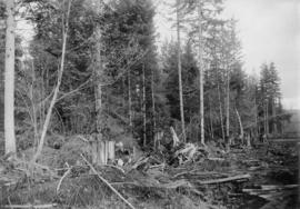
Area being cleared for development
Part of Bushnell family fonds
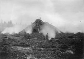
Area being cleared for development
Part of Bushnell family fonds
Area being cleared for development
Part of Bushnell family fonds

Area being cleared for development
Part of Bushnell family fonds
British Columbia Canada's most westerly province : its position, advantages, resources and climate
Part of City of Vancouver Archives technical and cartographic drawing collection
Item is a topographical plan of Point Grey showing the area from Angus Drive to Granville Street and 71st Avenue to the Fraser River, including property in D.L. 317 and D.L. 318. Plan shows the locations of the Vancouver and Lulu Island Railway, as well as ponds, dams, barns, houses and offices.
Farm lands in British Columbia
Information for intending settlers : with a map

Map of portion New Westminster District
Part of City of Vancouver Archives technical and cartographic drawing collection
Item is a heavily-amended copy of a map illustrating intended land settlement and subdivision in 1877 in the future sites of Vancouver, Burnaby and the North Shore, from an area bordering on English Bay to an area bordering on North Arm. Also shown are bodies of water, Hastings & Granville Road, and the settlements of Hastings and Granville. Annotations by J.S. Matthews in 1954 made on the copy are tracings in white pen and darkening the background to improve the copy.

Map of portion New Westminster District
Part of Major Matthews collection
Item is an annotated tracing of a map showing the future sites of Vancouver, Burnaby and the North Shore from an area bordering on English Bay to an area bordering on North Arm. Traced over by J.S. Matthews in 1954, it illustrates intended land settlement and subdivision in 1877. Also shown are bodies of water, Hastings & Granville Road, and the settlements of Hastings and Granville. Annotations are an introductory note by Matthews in August 1954 titled "Before Greater Vancouver." Enclosed with the map are four letters between J.S. Matthews and W.H. Hutchinson, Chief of the Geographic Division of the B.C. Survey and Mapping Branch of the Department of Lands and Forests, in 1954 concerning the map's provenance and Matthew's efforts to increase the legibility of copies of the original map.
Pioneers fittingly honoured at the exhibition

Part of Major Matthews collection
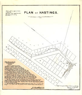
Map is a negative photostatic copy of a plan of lots offered for auction in Hastings on 10th July 1869, indicating which lots were sold and which lots were reserved. Plan also shows the locations of government buildings, a church, a hospital, Oliver M. Hocking's house and stable, the road from New Westminster to Burrard Inlet, Mae N. (Broughton), and [bearing] to Moody's Mill. This map does not include the typed note by J.S. Matthews, 1933, titled "First Sale of Lots, 1869 (City of Vancouver), Hocking's." The map was certified by Robert Beaver, C.C.L&W, as a true copy from the map in the Lands and Works Office, 21st June 1873. Also included with the map are drafts of the text by Major Matthews.

Part of Major Matthews collection
Map is a photostatic copy of a plan of lots offered for auction in Hastings on 10th July, 1869, indicating which lots were sold and which lots were reserved. Plan also shows the locations of government buildings, a church, a hospital, Oliver M. Hocking's house and stable, the road from New Westminster to Burrard Inlet, Mae N. (Broughton), and [bearing] to Moody's Mill. Includes a note by J.S. Matthews, 1933, titled "First Sale of Lots, 1869 (City of Vancouver), Hocking's." The map was certified by Robert Beaver, C.C.L&W, as a true copy from the map in the Lands and Works Office, 21st June 1873. Also included with the map are drafts of the text by Major Matthews.

Part of Major Matthews collection
Map is a negative photostatic copy of a plan of lots offered for auction in Hastings on 10th July 1869, indicating which lots were sold and which lots were reserved. Plan also shows the locations of government buildings, a church, a hospital, Oliver M. Hocking's house and stable, the road from New Westminster to Burrard Inlet, Mae N. (Broughton), and [bearing] to Moody's Mill. Includes a note by J.S. Matthews, 1933, titled "First Sale of Lots, 1869 (City of Vancouver), Hocking's." The original map was certified by Robert Beaver, C.C.L&W, as a true copy from the map in the Lands and Works Office, 21st June 1873. Also included with the map are drafts of the text by Major Matthews.

Part of Major Matthews collection
Map is a photostatic copy of a plan of lots offered for auction in Hastings on 10th July 1869, indicating which lots were sold and which lots were reserved. Plan also shows the locations of government buildings, a church, a hospital, Oliver M. Hocking's house and stable, the road from New Westminster to Burrard Inlet, Mae N. (Broughton), and [bearing] to Moody's Mill. This map does not include the typed note by J.S. Matthews, 1933, titled "First Sale of Lots, 1869 (City of Vancouver), Hocking's." The map was certified by Robert Beaver, C.C.L&W, as a true copy from the map in the Lands and Works Office, 21st June 1873. Also included with the map are drafts of the text by Major Matthews.
Part of Major Matthews collection
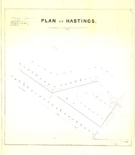
Map is a plan of lots offered for auction in Hastings on 10th July 1869, indicating which lots were sold and which lots were reserved. Plan also shows the locations of government buildings, a church, a hospital, Oliver M. Hocking's house and stable, the road from New Westminster to Burrard Inlet, Mae N. (Broughton), and [bearing] to Moody's Mill. Pasted onto the front of the map is a typed note by J.S. Matthews, 1933, titled "First Sale of Lots, 1869 (City of Vancouver), Hocking's." The map was certified by Robert Beaver, C.C.L&W, as a true copy from the map in the Lands and Works Office, 21st June 1873. Also included with the map are drafts of the text by Major Matthews.
Part of Major Matthews collection
Map is a photostatic copy of MAP 1037.01, showing a plan of lots offered for auction in Hastings on 10th July 1869 and indicating which lots were sold and which lots were reserved. Plan also shows the locations of government buildings, a church, a hospital, Oliver M. Hocking's house and stable, the road from New Westminster to Burrard Inlet, Mae N. (Broughton), and [bearing] to Moody's Mill. This map does not include the typed note by J.S. Matthews, 1933, titled "First Sale of Lots, 1869 (City of Vancouver), Hocking's." The map was certified by Robert Beaver, C.C.L&W, as a true copy from the map in the Lands and Works Office, 21st June 1873. Also included with the map are drafts of the text by Major Matthews.
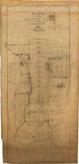
Plan of pre-emption claims, group 1, New Westminster District B.C., 1887-1888
Part of Major Matthews collection
Item is a map depicting pre-emption claims in Group 1, New Westminster District, a section of land extending north from Burrard Inlet and including Capilano Creek. The majority of claims are numbered and/or include the owner's last name. In addition to creeks, the map also shows the location of a waterworks dam, mountains, and high hills. Pencil annotations indicate the location of "Trythall's Clearing."
![Plan shewing [showing] division of property belonging to Major C.W. Hill](/uploads/r/null/0/f/0f72067c788c91a520f5055e8b1241e0ee99f2c20c434b03eca0174baea425dc/d22e8a25-814f-4266-99a4-24c639764600-MAP787_142.jpg)
Plan shewing [showing] division of property belonging to Major C.W. Hill
Part of City of Vancouver Archives technical and cartographic drawing collection
Item is a sketch plan of an area in South Vancouver encompassing Argyle Street, Harrison Avenue and Gritton Avenue. Plan shows the division of property belonging to Major C.W. Hill. The name of the person to which land was deeded and sometimes the date and the price paid is written on each lot.

Part of City of Vancouver Archives technical and cartographic drawing collection
Item is a map of the southwest coast of British Columbia from Cortes Island to Alta Lake and Chilko Lake to the northern tip of Gabriola Island. Map shows timber leases, Crown granted land, parks, municipalities, power lines, roads, railways, elevation of lakes and some mountains, hospitals, schools and canneries.
Reply of the Honourable W.J. Bowser, K.C., to the pamphlet entitled The crisis in B.C.
Scarborough's New Map of British Columbia
Part of City of Vancouver Archives technical and cartographic drawing collection
Map of British Columbia shows railways, steamship lines, cities, and villages. The map has a detailed inset of Northern British Columbia. The map also has an index of cities, villages, post offices, and station with populations from 1911 Canadian Census. Note on tube: 7F Map of B.C.
The westernmost identifiable point on the map is Graham Island and the easternmost city is Calgary, while the northernmost is Cleveland Peninsula, and the southernmost is the Juan de Fuca Strait.
The crisis in B.C. : an appeal for investigation
The Dominion Shipbuilding, Engineering, and Dry Dock Company Limited
The province of British Columbia, Canada, its resources, commercial position and climate
The work of the of Royal Engineers in British Columbia 1858-1863