
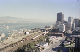
- AM54-S4-: SGN 442
- Item
- [1898?]
Part of Major Matthews collection
J.S. Matthews' notes with print or negative in Archives.
162 results directly related Exclude narrower terms
Part of Major Matthews collection
J.S. Matthews' notes with print or negative in Archives.

Part of Major Matthews collection
J.S. Matthews' notes with print or negative in Archives.

Part of Major Matthews collection
J.S. Matthews' notes with print or negative in Archives.
![[C.P.R. ship "Empress of Russia" passing Brockton Point]](/uploads/r/null/1/8/1806a80fe9c830d1b4a558ee718b1cf2904609dcad4a1b17dbff9050186aa742/2bd24025-a6d6-49c3-9653-ca473c56f30c-A08732_142.jpg)
[C.P.R. ship "Empress of Russia" passing Brockton Point]
Part of Major Matthews collection
J.S. Matthews' notes with print or negative in Archives.
![[The ship "Empress of Japan" passing through Burrard Inlet]](/uploads/r/null/2/d/2d8e2295d2564386bb95812ed2467f4fef69651ad9408fb7dacdfb85d0d45ef4/da5156b8-1826-4954-9178-f56edcb82895-A08734_142.jpg)
[The ship "Empress of Japan" passing through Burrard Inlet]
Part of Major Matthews collection
J.S. Matthews' notes with print or negative in Archives.
![[The ship "Empress of Japan" passing through Burrard Inlet]](/uploads/r/null/1/4/142d77d89087efd24091dcf0fcaff7f8bcbeba8f9392e1b64a5639855daf877b/b005afba-5475-42fd-a688-076226b4bba9-A08735_142.jpg)
[The ship "Empress of Japan" passing through Burrard Inlet]
Part of Major Matthews collection
J.S. Matthews' notes with print or negative in Archives.
![[C.P.R. ship "Empress of Canada" passing through First Narrows of Burrard Inlet]](/uploads/r/null/4/2/42b87943fb11050707df2e351ca7ce69af9324c8905d463cf424cd836bf33b8d/bbe79e56-ff99-4056-be77-ea0f20bf65ca-A08741_142.jpg)
[C.P.R. ship "Empress of Canada" passing through First Narrows of Burrard Inlet]
Part of Major Matthews collection
J.S. Matthews' notes with print or negative in Archives.
![[C.P.R. ship "Empress of Canada" passing through First Narrows of Burrard Inlet]](/uploads/r/null/3/e/3e20df9b49a80632e697cf2cc6aac564197245b4380895bd8738c0fc817923bd/ab7eca47-0283-46f9-a431-de5ccacf56a4-A08742_142.jpg)
[C.P.R. ship "Empress of Canada" passing through First Narrows of Burrard Inlet]
Part of Major Matthews collection
J.S. Matthews' notes with print or negative in Archives.
![[C.P.R. ship "Empress of Canada" entering first narrows of Burrard Inlet]](/uploads/r/null/6/f/6fdedb618c51b280546f4287f814374d636cacc6f9be2b6a040d0319f9025a40/04fe502c-437c-4259-b738-c1facd3b2a62-A08743_142.jpg)
[C.P.R. ship "Empress of Canada" entering first narrows of Burrard Inlet]
Part of Major Matthews collection
J.S. Matthews' notes with print or negative in Archives.
![[C.P.R. ferry "Princess Patricia" in first narrows of Burrard Inlet]](/uploads/r/null/9/e/9e69bf44a7b3fcd54d72d399d3daafda07a93c51e6e4ecfa5c1d496bb5264ae9/fdad8b56-b9b1-4fda-b184-511134dd52f5-A08759_142.jpg)
[C.P.R. ferry "Princess Patricia" in first narrows of Burrard Inlet]
Part of Major Matthews collection
J.S. Matthews' notes with print or negative in Archives.
![[Dredging of first narrows of Burrard Inlet]](/uploads/r/null/0/6/067d7dfedaf5352387ac2fd676a32a47bcfd04148596086054a68b443c577f1a/c4986380-fb1f-45f4-bcf1-18d400c4dd03-A08776_142.jpg)
[Dredging of first narrows of Burrard Inlet]
Part of Major Matthews collection
Photograph shows ships and dredging machinery near shore. J.S. Matthews' notes with print or negative in Archives.
![[View looking west from Vancouver Heights]](/uploads/r/null/a/b/abea52b2244ba2c43a15267f493517e431d982047fad5ea7c13c63bddecd73d7/468decc1-9f9c-4c9f-ad94-d67f993c03b8-A09869_142.jpg)
[View looking west from Vancouver Heights]
Part of Major Matthews collection
Photograph shows waterfront houses in Burrard Inlet with boats and log booms across the inlet , the Hastings-Sunrise district and Stanley Park in the distance.
![[View of the First Narrows of Burrard Inlet from Prospect Point]](/uploads/r/null/2/c/2c97ca6f4a8d931190ca573e8e9d52837a1531d6aaee77e5316c1ffb2ded5b7a/cb526b98-93c9-4de7-8836-6748ae4b6980-A09874_142.jpg)
[View of the First Narrows of Burrard Inlet from Prospect Point]
Part of Major Matthews collection
![[View of the First Narrows of Burrard Inlet from Prospect Point]](/uploads/r/null/f/4/f4d1521d08e033c007d39ba57e610efd575f2fb7a9247b2c5706f058dacb9085/a9e78751-29a7-406b-8c2c-9e36f8278490-A09875_142.jpg)
[View of the First Narrows of Burrard Inlet from Prospect Point]
Part of Major Matthews collection
![[View of First Narrows from Prospect Point]](/uploads/r/null/a/b/ab6098140a0949ae1bed78d001b1481902a19ecf21ce7cbd0ed6960562873ce9/17ea376e-fe62-4d2e-b712-33ac379564ba-A24061_142.jpg)
[View of First Narrows from Prospect Point]
Part of Major Matthews collection

Part of Major Matthews collection
Photograph shows the first C.P.R. office, the back of the Edward Bros. Studio and Hasitngs Mill
![[Fairview looking west across False Creek]](/uploads/r/null/5/3/530c1602976afb68dba7c39f098a0a2dd5b251f4f37cb95836fc30f1f5877280/8ef64e7f-ca79-41ee-b3cc-070bc0f90b28-A25939_142.jpg)
[Fairview looking west across False Creek]
Part of Major Matthews collection
Panoramic view showing the False Creek Indian Reserve, Granville and C.P.R. Kitsilano Trestle bridges and Edward Chapman's residence.
![[View of West End and Yaletown from Fairview]](/uploads/r/null/9/9/99ae5cc2d1ce7b9eb63e0a0c4e048e130b8ee84a4cf7c81a038f3b77fb749b71/322c7cf7-a463-4e23-a0cb-3ce4a74ffc61-A25940_142.jpg)
[View of West End and Yaletown from Fairview]
Part of Major Matthews collection
Panoramic view
![[Eastern view of False Creek from Fairview]](/uploads/r/null/4/2/4277723ceb6aa63994df422f6ded5892cf22f11b860a78157db74acd5abe5048/913f6e38-fc88-4795-b030-030ec68a5f8a-A25941_142.jpg)
[Eastern view of False Creek from Fairview]
Part of Major Matthews collection
Panoramic view showing the Connaught and Westminster Avenue bridges.
![[View of Pacific Coast Lumber Mill across Coal Harbour]](/uploads/r/null/5/5/5518d48d4223310dbaf4a33f63c011b0157128fb6ca8987a399880ea954843a8/5899a6f7-332c-4818-ac99-085512a8ea00-A32559_142.jpg)
[View of Pacific Coast Lumber Mill across Coal Harbour]
Part of Major Matthews collection
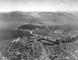
![[Aerial view of Vancouver showing West and North Vancouver in the distance]](/uploads/r/null/8/d/8d777f00e47e79c44a6ac156af179a087158c26ea0c533480d2a2fb614a2f72e/3d4beb27-2bde-4b39-9fa9-51ad4fca5418-A37529_142.jpg)
[Aerial view of Vancouver showing West and North Vancouver in the distance]
Part of Major Matthews collection
Oblique view showing hand-drawn Burrard, Kitsilano Trestle, Granville, Cambie Street and Lion's Gate Bridges, the causeway through Stanley Park and the street system of Capilano Estates
Part of Major Matthews collection
Oblique view showing the Burrard Bridge under construction, the Kitsilano Trestle, Granville and Cambie Bridges, Kitsilano, Granville Island, False Creek, Fairview, Mount Pleasant, Yaletown, Downtown, West End, Stanley Park and Vancouver Harbour
![Columbia Grain Elevator [at] 2700 Wall St[reet]](/uploads/r/null/d/b/db9e431c74309abf7b571a7b79e143b2b5aa6f6fbfb95d3c02febcf316dd51a7/a7992d41-6743-4352-9323-68a9e2bd18c1-A58892_142.jpg)
Columbia Grain Elevator [at] 2700 Wall St[reet]
Part of City of Vancouver fonds
Photograph also shows the North Shore and the Burrard Inlet
![Columbia Grain Elevator [at] 2700 Wall St[reet]](/uploads/r/null/c/8/c8cd7e6c3afb916bb1ee20504a9f2328e069842e4bb64d21953cbc1771c417cf/69bf5a92-ccf4-4eb8-ab72-8d56c173178a-A58893_142.jpg)
Columbia Grain Elevator [at] 2700 Wall St[reet]
Part of City of Vancouver fonds
Photograph also shows the Burrard Inlet and the Second Narrows Highway Bridge
![Columbia Grain Elevator [during demolition at] 2700 Wall St[reet]](/uploads/r/null/2/5/25f3f0709f0614e46d3833ae4d26227abe383cca0d4e9101241939bf35b0f693/955469dc-dd85-4dfa-8d9e-9124d145c4cb-A58894_142.jpg)
Columbia Grain Elevator [during demolition at] 2700 Wall St[reet]
Part of City of Vancouver fonds
Photograph also shows the Burrard Inlet and the Second Narrows Highway Bridge
![[Northwest facing cityscape view of Mount Pleasant]](/uploads/r/null/1/a/1a8e45a404893b76fbce13ae65f1d98bf633b22ee02126f11bda277730967c14/ff1fc560-a87d-486b-8fc6-c2ddbed44d41-A59084_142.jpg)
[Northwest facing cityscape view of Mount Pleasant]
Part of City of Vancouver fonds
Photograph also shows False Creek, sawmills along False Creek, Burrard Inlet and the North Shore; photograph also shows buildings downtown including the Marine Building (355 Burrard Street), Dominion Building (207 West Hastings Street), and the Sun Tower (100 West Pender Street)
Looking Across Burrard Inlet from Vancouver, B.C.

British Columbia - Vancouver skyline
Item is photograph showing downtown Vancouver and Burrard Inlet at night.

British Columbia - Vancouver skyline
Item is aerial photograph showing downtown Vancouver and Burrard Inlet.

British Columbia - Vancouver skyline
Item is aerial photograph showing downtown Vancouver and Burrard Inlet.
![[Ship in Burrard Inlet]](/uploads/r/null/b/f/bf0a15903f489fdd5b52ad2a82bf2cc55e5a267c59f932f114c5302fe9f3a26e/d9ff15fb-450f-45ba-a848-a04fe390bfbb-A37898_142.jpg)
![["Mohican", navy vessel in Burrard Inlet]](/uploads/r/null/4/1/41d8f6b6f815e272c9bb35ee67ac6658c6c3dc352544a6000c8ff0ccc9d92ec6/beeba370-9be1-4f3c-a0c7-178659c3facc-A37902_142.jpg)
["Mohican", navy vessel in Burrard Inlet]

British Columbia - Vancouver skyline
Item is aerial photograph showing downtown Vancouver and Burrard Inlet.

British Columbia - Vancouver skyline
Item is aerial photograph showing Coal Harbour and Burrard Inlet
British Columbia - Vancouver skyline
Item is aerial photograph showing part of Coal Harbour and Burrard Inlet.
British Columbia - Vancouver skyline
Item is aerial photograph showing part of Coal Harbour and Burrard Inlet.

British Columbia - Vancouver skyline
Item is aerial photograph of downtown Vancouver and Burrard Inlet.

British Columbia - Vancouver skyline
Item is aerial photograph showing Coal Harbour and Burrard Inlet.

British Columbia - Vancouver skyline
Item is aerial photograph of downtown Vancouver and Burrard Inlet.

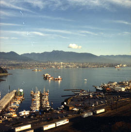
British Columbia - Vancouver Skyline
Item is aerial photograph showing downtown Vancouver, Stanley Park, and Burrard Inlet.

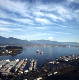
British Columbia - Vancouver skyline
Item is aerial photograph showing a panoramic view of downtown Vancouver and Burrard Inlet.

British Columbia - Vancouver skyline : Westcoast bldg. and scenery from inside
Item is photograph showing Burrard Inlet, taken from Westcoast Energy office building.

British Columbia - Vancouver skyline : Westcoast bldg. and scenery from inside
Item is aerial photograph showing Burrard Inlet and office buildings in downtown Vancouver.

British Columbia - Vancouver skyline : Westcoast bldg. and scenery from inside
Item is aerial photograph showing apartment and office buildings in downtown Vancouver.

British Columbia - Vancouver skyline : Westcoast bldg. and scenery from inside
Item is photograph showing Coal Harbour, Stanley Park, and Burrard Inlet.

British Columbia - Vancouver skyline : view from north side of Westcoast bldg
Item is photograph showing view of Burrard Inlet from Westcoast Energy building.

British Columbia - Vancouver skyline : view from north side of Westcoast bldg
Item is photograph showing view of Coal Harbour, Stanley Park, and Burrard Inlet from Westcoast Energy building.
British Columbia - Vancouver skyline : view from north side of Westcoast bldg
Item is photograph showing view of Burrard Inlet and part of downtown Vancouver from Westcoast Energy building.

British Columbia - Vancouver skyline
Item is photograph showing downtown Vancouver and Burrard Inlet at night.

British Columbia - Vancouver skyline
Item is photograph showing Burrard Inlet, Coal Harbour, and Stanley Park.