
- AM1376-: CVA 229-08
- Item
- 1909
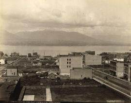
Item is a photograph showing a view of Granville Street looking north towards C.P.R. Station and North Shore Mountains.
Item is a photograph showing a view of Granville Street looking north towards C.P.R. Station and North Shore Mountains.
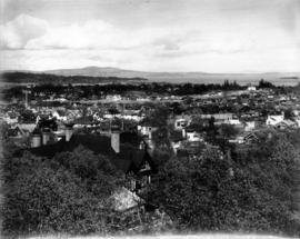
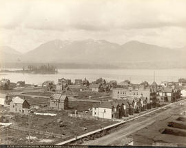
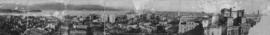
Photograph shows a view of a residential section of Victoria
![[Aerial view of Vancouver]](/uploads/r/null/9/b/9b3acec26123edc53f11bf2f41f3286d09254ffea9918cd31b6715395ebe18d0/26473909-fe49-4474-8c3f-05eb1e8ab059-CVA1376-252_142.jpg)
Oblique view showing Fairview, Vancouver General Hospital, False Creek and the Expo 86 and other sites under development on the north side, Granville Island, Granville Bridge, Burrard Bridge, Yaletown, Downtown, the West End, Stanley Park and the Lions Gate Bridge, North Vancouver and The Lions in the background

Photograph shows Alexandra Bridge in the background

Photograph shows the cave and basin (hot springs pool)

Banff National Park from Cave Hot Springs

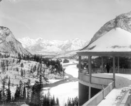
Banff Springs Hotel from Mount Rundle


Bow River Valley From Hot Springs, Banff National Park


Photograph shows a view from the beach below the range
![C.P.R. Hotel from across the Bow [River]](/uploads/r/null/d/3/d3a80de5b951f1842415374308c3a996d505e2e41da6e75237d796f48373a3c0/db67449f-16bd-482f-8c40-73bfb8fb65fa-A20027_142.jpg)
C.P.R. Hotel from across the Bow [River]
Photograph shows the Banff Springs Hotel
![C.P.R. Hotel from across the Bow [River]](/uploads/r/null/6/7/67123ef2c87b6798e0cfaac1f764f7e119c3b51efc66b476abcb2eee7f4e4e28/415b9b34-4136-4267-aef8-7b547e494120-A20028_142.jpg)
C.P.R. Hotel from across the Bow [River]
Photograph shows the Banff Springs Hotel

Photograph shows a view through the trees at low tide
![[Eighteen views along the C.P.R. route in the mountains of Alberta and British Columbia]](/uploads/r/null/9/f/9f46ce204e1b7556e067fa5a9672752a7f09fb8ad72e1b3bba8a68b26bf2ac37/b39650aa-39ec-489b-a6ee-2ea8673fc849-A20175_142.jpg)
[Eighteen views along the C.P.R. route in the mountains of Alberta and British Columbia]
![English Bay, Vancouver, B.C. [at sunset]](/uploads/r/null/1/2/12d397a861ea3910641fa736f0c2d2498d0f2892db2515821653ca2ce6123ad7/ecfa4d63-dc1a-4347-8511-6936ac389a44-A20135_142.jpg)
English Bay, Vancouver, B.C. [at sunset]
Photograph shows a view towards Point Grey

![[Five views from the Banff area]](/uploads/r/null/b/9/b9d0611481b16039b26cc7b3cdb321a420bca195f475cf322fe35d3279c59f7e/569e4442-7b23-4b3c-9083-4a79e9942af4-A20176_142.jpg)
[Five views from the Banff area]
![[Five views of Alberta and British Columbia]](/uploads/r/null/0/c/0c93a0ce5b2eaafa492bd1d44aada884091dba96c9d6db20b1c91ad9064ceac0/75f9a2be-7368-4418-9734-dd00ec5fc32f-A20186_142.jpg)
[Five views of Alberta and British Columbia]
![Flett Road [East 18th Avenue] east of Knight Road [Street in Cedar Cottage]](/uploads/r/null/5/d/5d59076afb046ed723b664f2d976a42d6191b20f58a870480a1b3a104f9b3e62/3962b6fd-a308-416a-9d1d-3dd2d4494166-A43626_142.jpg)
Flett Road [East 18th Avenue] east of Knight Road [Street in Cedar Cottage]
![[Four views from Alberta and British Columbia]](/uploads/r/null/3/6/3616a50d5db98b946d72c057f70fd14f6b700666f584af438e80eec40442005e/769c13ad-a45e-4e73-99e6-4d1cd0dc9753-A20182_142.jpg)
[Four views from Alberta and British Columbia]
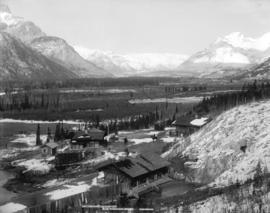
Photograph shows a view overlooking the town


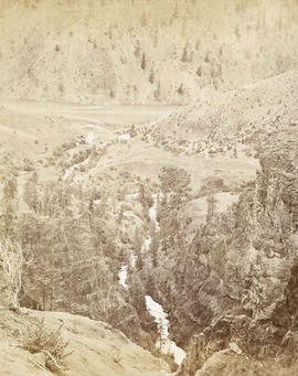
Illecillewaet Valley from Look Out on Mount Abbott
Photograph shows two snow sheds and a railroad bridge
![Lady Franklin Rock [in the Fraser River near Yale]](/uploads/r/null/3/0/30e4a67b983698de8acc03740dd17a80e4f7a567b29da2ea51be9ea5c379c930/ee5161f4-0613-4294-9296-359f4eb8958f-A19670_142.jpg)
Lady Franklin Rock [in the Fraser River near Yale]
Photograph shows a view from the top of the Fraser Canyon

Looking across English Bay from the beach on Point Grey Road
Looking Across the Inlet from Hotel Vancouver
Photograph shows a view looking north from Georgia Street showing the west side of the 600 Block Howe Street including Manor House and beyond to Deadman's Island
Looking Across the Inlet from Hotel Vancouver
Photograph shows a view looking north across Burrard Inlet from Granville Street and Georgia Street including the Van Horne Block and the Hudson Bay Company Store
![Looking north, our house [in Cedar Cottage]](/uploads/r/null/d/c/dcd996eac0a13402f4d8523881fb8c843a7e540f74defd5934cbc0f7e8aef362/03eb79a9-190d-4494-96af-15b33b1b7a0a-A43610_142.jpg)
Looking north, our house [in Cedar Cottage]
Photograph shows cleared lots and houses in the background
![Looking south from Knight Road [Street and 15th Avenue in Cedar Cottage]](/uploads/r/null/c/4/c40d25f0ce8d064000ee17882a33987e35d7dd3b1a95c189c9745f99adecc4b6/cca6bd4c-d41c-4105-a346-3e034016f971-A43609_142.jpg)
Looking south from Knight Road [Street and 15th Avenue in Cedar Cottage]
Photograph shows a burnt tree stump and houses in the background
![[Military camp near Vernon]](/uploads/r/null/f/2/0/f209c6aac94b5a37b8e033ec4f3d9c45ffbfe3fabf794ddf5ac3a16ac1ae6540/0f360e46-6651-4b67-890b-e66087441b7b-CVA73-3_142.jpg)
Panoramic view showing a group portrait of officers in front of "Camp Headquarters" spelled in stones

Moodyville Milling Company's Mills, Moodyville, B.C.

Mount Sir Donald, C.P.R. Selkirks, Height 10,645 feet

Photograph shows a view of New Westminster from across the Fraser River

Nicaragua Bluff and wagon road from west side of Fraser River
Nicomen looking down the creek to the Thompson River - 67 miles above Yale
![Nine scenes on the C.P.R. route [through Alberta and British Columbia]](/uploads/r/null/6/5/653f1c0ee5c3d937df706442e5c70e7993c7f4d0c3a060b063b1b0d8070a968d/ca313a1b-6ce1-4ae5-970c-228b90ce225e-A20158_142.jpg)
Nine scenes on the C.P.R. route [through Alberta and British Columbia]
![[Nine views from Vancouver and the Rocky Mountains]](/uploads/r/null/9/e/9ecba75b19032bc2dc87d74e5d5da1f0cb99a42cc6d8728fa7e6723f64fd04d8/cad83a8a-ad73-4373-807b-2884d5f28fc6-A20181_142.jpg)
[Nine views from Vancouver and the Rocky Mountains]

Northwest Mounted Police Headquarters at Regina
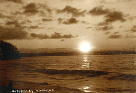
On English Bay, Vancouver, B.C.
Photograph shows the setting sun
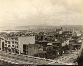
Panorama of Vancouver, B.C. Canada
Panoramic view looking north showing Deadman's Island, Brockton Point, part of the West End, Downtown including the Immigration Building, the Marine Building under construction, the Rogers Building, the turret of the Bank of Montreal, the post office clock tower, the Sun Tower, the second Hotel Vancouver and the North Vancouver Ferry in the background
Part of Vancouver, B.C. from Hotel Vancouver
Photograph shows the east side of the 600 Block of Granville Street including the New York Block and a liquor store and beyond to the Homer Street Methodist Church, the tower of Holy Rosary Cathedral and houses
![[People sitting on benches enjoying the view]](/uploads/r/null/f/2/f2297a6ddaf371b8434aa486cb82614fdd15854c1c4abf09f4a48a8d0b227e32/46e5f70e-2dfd-4622-8d9f-46411a65da05-A71861_142.jpg)
[People sitting on benches enjoying the view]
![[R.C.A.F. Maritime Air Command plane No. 102 flying over English Bay]](/uploads/r/null/1/3/13b6c7a118ed10801cfbe633df28806771f06f62a484edbf5de83c5acd20e0a4/ff8af309-b1af-4c30-9216-ba8a2859660d-A71302_142.jpg)
[R.C.A.F. Maritime Air Command plane No. 102 flying over English Bay]
Oblique view showing the Vancouver Maritime Museum and Kits Point residences in the foreground, and the West End, Downtown, Stanley Park and Burrard Inlet in the background.

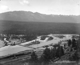
Photograph shows a view overlooking the town

Salmon Traps Off Point Roberts
![[Six views from Banff]](/uploads/r/null/7/b/7b7adcf305d5fa38b2d06102e3f8a2173eadcaeb0dcab24471dda662f3c17bed/9467fe8a-e492-40ab-be71-b0fa228e9e2c-A20183_142.jpg)