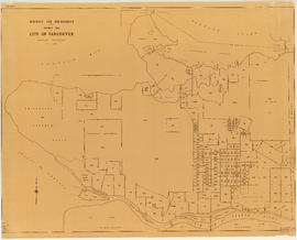
- AM1594-: MAP 748
- Item
- 1915
Part of City of Vancouver Archives technical and cartographic drawing collection
Item is a map showing parade grounds, grand stand and drill hall in the area from Dunsmuir Street to Cambie Street to Georgia Street to Beatty Street. Legend in bottom left corner shows symbols for the following: iron fence, wire screen, goal posts, C.P.R. railway, car tracks, trees and contours. A letter about map from Major Matthews adhered to top right corner. Pencil annotation showing 158th Battalion men's quarters by Major Matthews


![Legend [for colour coding land use]](/uploads/r/null/3/1/2/3120f4f71566883ae774f5f08ae6795bc55fcd40d9f4bdd29f8f25dc782e0a9f/89bc7dbc-376d-43ba-bc88-a0fda629d99a-LEG1153_142.jpg)


![Map showing City of Vancouver, British Columbia [index map]](/uploads/r/null/a/f/b/afbf0b3832ff37e3af2c10d63547517135bca50be83ddddfcd25914b3c7b8f1d/6903af1e-3c6e-4577-9c0a-0967550524a7-LEG1153_142.jpg)