![[House in Kitsilano]](/uploads/r/null/4/c/4c8fe7223209756140c114e5f1be05ce632f89c7896df0c91fbece8756f2aa9f/2a1db002-789d-4824-9c92-f01c8f3d138d-A58934_142.jpg)
- COV-S511---: CVA 780-154
- Item
- [between 1960-1980]
Part of City of Vancouver fonds
Part of City of Vancouver fonds
![[Point Grey Road Waterfront Park]](/uploads/r/null/c/9/c9faa13bb2b8c2f0c429b90d90f959707687ba72f7bd3c75e051e307f14f8b61/85333e38-c299-4184-ad33-fece41a848f0-A58944_142.jpg)
[Point Grey Road Waterfront Park]
Part of City of Vancouver fonds
Photograph also shows the North Shore and Stanley Park
![[Houses in Kitsilano]](/uploads/r/null/a/6/a6eb98108e3ef8cf28e473f7f1e790452b9e1d4b5e50554dadbde27b8f9741ef/3959becb-dbff-4706-894a-d06e2572cafa-A58935_142.jpg)
Part of City of Vancouver fonds
![[Park in Kitsilano]](/uploads/r/null/4/3/431c20410056dfd271b6afb44f676c394e28cc057432e4878ea260b313f46c03/5e5665ff-d0bc-467c-ae60-c9f5a1fbd4de-A58941_142.jpg)
Part of City of Vancouver fonds
![[View of a street in Kitsilano]](/uploads/r/null/9/c/9c7605db247e732401523c12194bab0011f846a8e9b03456c3aa7930dbcdbc72/7f8904bc-1158-4433-832e-77f917e7e04e-A58942_142.jpg)
[View of a street in Kitsilano]
Part of City of Vancouver fonds
Photograph also shows a house]
![[Kitsilano Secondary School at 2550 West 10th Avenue]](/uploads/r/null/d/9/d948ed1b439eeea7151c09ff01708341f7f3bb8e611fe5a482b710adfb176524/994d8698-c7b5-4606-b8bb-bf8fe56e95d9-A58969_142.jpg)
[Kitsilano Secondary School at 2550 West 10th Avenue]
Part of City of Vancouver fonds
![RCAF Base [No. 2 Equipment Depot in Kitsilano]](/uploads/r/null/5/f/5ffae0cf94e2d913d0fec944aaffddf8db7f954af140054ac9eb9b44a4a6b715/77297584-bc04-48c2-869d-d7f3713fd429-A59297_142.jpg)
RCAF Base [No. 2 Equipment Depot in Kitsilano]
Part of City of Vancouver fonds
Photograph also shows False Creek, English Bay and the West End
![[Shops along West] 4th Ave[nue] and Cypress [Street]](/uploads/r/null/b/4/b40dc85512f5f69b085b35dc4bb64e04c82b5feed0c5205c111b959b8e435314/578e715a-2631-43fd-88f2-c080a9ab705e-A58974_142.jpg)
[Shops along West] 4th Ave[nue] and Cypress [Street]
Part of City of Vancouver fonds
Photograph also shows buildings and businesses including the Cypress Confectionery (1903 West 4th Avenue)
![[View of the 3000 block] Broadway](/uploads/r/null/8/6/866f8e73745300bf939bfbd62ad4e5432855543093ddfa373476f9cbca7100ce/2f902ec8-3873-45e7-93fc-cb3f95a57662-A58976_142.jpg)
[View of the 3000 block] Broadway
Part of City of Vancouver fonds
Photograph also shows buildings and businesses including Almadene Cleaners (3667 West Broadway), Ruth's Grocery (3663 West Broadway), Broadway Shoe Service (3661 West Broadway), and Earl Smith Interior Designers (3657 West Broadway)
![[Kitsilano Beach]](/uploads/r/null/7/f/7faaee3b1e95a802e761c36b711ba1954bd00c87285b8dfbe46ed1f6daa95569/435ef841-371c-41cf-a55f-4524781f2195-A58943_142.jpg)
Part of City of Vancouver fonds
![[Shops along] 4th [Avenue] and MacDonald [Street]](/uploads/r/null/e/4/e4e2c71e9c3f7a413d4d21c9aa1c80f8f1caaed5aca9d43d28a567fb1f2ee75a/f83242b1-e966-40fd-84be-a71267749cb7-A58973_142.jpg)
[Shops along] 4th [Avenue] and MacDonald [Street]
Part of City of Vancouver fonds
![[View of the Mother Hubbard Bakery signage at 2106 West Broadway]](/uploads/r/null/3/c/3cf93615c34e570c386986fbc4188fc52c13550e44b83ce8017c87d142e5bde8/bd7443aa-9a94-46c7-b568-189a9690a39e-A58977_142.jpg)
[View of the Mother Hubbard Bakery signage at 2106 West Broadway]
Part of City of Vancouver fonds
![[Apartment building Cedar Terrace at 6001 Yew Street]](/uploads/r/null/e/d/edebbbb7bf5d62ce5c8d29437f731cbb3897bbaffffd5d99b96f79359a749c61/9b6e7d2b-9850-46f6-b65c-6da5b7b51049-A58931_142.jpg)
[Apartment building Cedar Terrace at 6001 Yew Street]
Part of City of Vancouver fonds

Part of City of Vancouver fonds
Map is a plan of the area bounded by Balsam Street, 3rd Avenue, Arbutus Street and Broadway, showing streets, blocks, lots and legal descriptions. Lots along Fourth Avenue are hand coloured to indicate the period of erection of the structures upon them. Also indicated are those buildings over one storey in height and buildings contructed of masonry. Plan is labelled " K, 1961 April, 3942B, small."
Part of City of Vancouver fonds
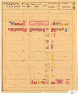
Map is a plan of the area bounded by Balsam Street, 3rd Avenue, Arbutus Street and Broadway, showing streets, blocks and some buildings. Structures are indicated on the plan for Yew Street between Fourth Avenue and Broadway and for Fourth Avenue, between Balsam and Arbutus Street. Structures are hand coloured to indicate land use, such as single family dwellings or business offices. Plan is labelled " K, 1961 April, 3941B, small."
![[Park in Kitsilano]](/uploads/r/null/8/c/8c788190e799e3dce0c8fba93d7be61805bef5fb9721a4981138f4f1efd0f381/7a808d97-5e29-42e3-b621-1c23c92a66d1-A58939_142.jpg)
Part of City of Vancouver fonds
Photograph also shows Kitsilano Beach
![[House in Kitsilano]](/uploads/r/null/2/c/2cca716acb48e681bc19cb724a08342b541ece9647f7ce81b57b9e2f4c6dbdfa/a0f5613d-51e7-433b-b021-22353a21d77b-A58932_142.jpg)
Part of City of Vancouver fonds
![Apartment at Point Grey Road [and] Trafalgar [Street]](/uploads/r/null/2/a/2a694cc2c7bc84e59a158dea82c83ed82714931df278c7a8d1ca692a147a51d0/8c421549-07a0-4c90-b1cf-fbff4245afcb-A58933_142.jpg)
Apartment at Point Grey Road [and] Trafalgar [Street]
Part of City of Vancouver fonds
![[Houses in Kitsilano]](/uploads/r/null/7/e/0/7e04217e7957c0cf375ee29846bc04c16dc03d0edc9159cbe9a098035b3bc611/5737f27b-73a6-44a7-95c3-6f0befffbbe7-CVA808-4_142.jpg)
Part of City of Vancouver fonds
![[Apartment building in Kitsilano]](/uploads/r/null/8/2/3/8239e25ae06bc295205685eb203081e738fd0431333b1a6013005b3f755a054b/d33dd649-9729-40e4-a219-fc60d3ec66a1-CVA808-2_142.jpg)
[Apartment building in Kitsilano]
Part of City of Vancouver fonds
![[Houses in Kitsilano]](/uploads/r/null/5/5/a/55ae24b66c9ac313c74635184be9b941fe7fcc4e380ac339b43e37f6bab74b24/507164fd-a66d-41a4-924d-9f6f1160f8d1-CVA808-1_142.jpg)
Part of City of Vancouver fonds
![[House and apartment building in Kitsilano]](/uploads/r/null/d/8/c/d8c500b307b5843514b956ebff2aea2d01dee6cf53aad693005afa24bad82cb9/49c0fa67-4e22-4316-9e46-f13f440aa067-CVA808-3_142.jpg)
[House and apartment building in Kitsilano]
Part of City of Vancouver fonds
![[Houses in Kitsilano]](/uploads/r/null/3/4/4/344d15796f2c3500294073c90fa782c0f0f8a63a01053fb3c2784628527b336b/53f61997-50b3-44f2-9970-73647972523e-CVA808-5_142.jpg)
Part of City of Vancouver fonds
![[Houses in Kitsilano]](/uploads/r/null/a/3/f/a3f2366e0cb3221dc412ce3a991413c10590721500a7c5ead1b32b4de3ee3e8e/ffe1bef9-efb5-41aa-a862-59a8dd8597c8-CVA808-6_142.jpg)
Part of City of Vancouver fonds
![[Apartment buildings at] 3rd [Ave W] and Stephens](/uploads/r/null/d/e/def548ce93bec90acfa42282ecb44b18ba81a6496b421bbb2d79aa47f4fd1c4a/dd7239e3-9e5f-4bc5-b691-01c1ea62dfe1-A58928_142.jpg)
[Apartment buildings at] 3rd [Ave W] and Stephens
Part of City of Vancouver fonds
![[Park in Kitsilano]](/uploads/r/null/5/0/50865667f2f73aaa6f5a1276ba9d89dff63332daa130139ff3cf4a79afb9dec7/438ccbe4-ec5f-4389-b02a-3538e004f960-A58937_142.jpg)
Part of City of Vancouver fonds
![[Street in Kitsilano]](/uploads/r/null/9/9/995b64e959c5d0a2bd16b4ad59feda2f735201ac7a9d2440b83b0ff59c9015f7/26acbbfe-74dd-4783-b448-a76b1f679dc7-A58952_142.jpg)
Part of City of Vancouver fonds
Photograph also shows houses
![[Houses in Kitsilano]](/uploads/r/null/1/4/14531163dbf358f0f6ae37f29a12e6fc125f75cfcfa21f51a255ca87e477df11/240e282b-04fe-4f58-b0d2-6224bece0b9e-A58929_142.jpg)
Part of City of Vancouver fonds
![[Street in Kitsilano at McNicoll Avenue]](/uploads/r/null/9/f/9f85bec92705b4a14427398af91174ed15a8a950b1a30e108ef60e121955de34/4497797d-670e-4f70-91af-a6317147272f-A58953_142.jpg)
[Street in Kitsilano at McNicoll Avenue]
Part of City of Vancouver fonds
Photograph also shows houses
![Naam Natural Foods Restaurant [at 2722 West 4th Avenue]](/uploads/r/null/c/4/c476b0e0b9884812dcfac5869fafdc9d5e86e275b6929c51fcd44c1f5824c215/a903a543-41ad-463c-a54d-aa5f018756f0-A58975_142.jpg)
Naam Natural Foods Restaurant [at 2722 West 4th Avenue]
Part of City of Vancouver fonds
![[Houses in Kitsilano]](/uploads/r/null/7/6/76a96f445b329049d2888e0c83eb0953cff44b145f88befbf95d00ff5f5bfc8c/2327eb87-d5b5-4094-9ae9-a032d33fe9f8-A58927_142.jpg)
Part of City of Vancouver fonds
![[Park in Kitsilano]](/uploads/r/null/0/f/0f786d95281cee62f10de2bc2ae3b535ab86ad22c0f0a04d5983c707cea7300c/98c50fdd-a92a-461d-a048-ef1db4db987d-A58938_142.jpg)
Part of City of Vancouver fonds
![[Houses in Kitsilano]](/uploads/r/null/6/8/68f06ce6dde97dc34d6de508380ae6b1aa75c28f43f3ea4b0f58e46e584a4ef3/f61f1fae-b54c-4ae2-8b7f-18e22557f2be-A58936_142.jpg)
Part of City of Vancouver fonds
Photograph also shows a railway crossing
![[Cityscape of Kitsilano looking North]](/uploads/r/null/2/0/20a1900669c168d04ff275a3805145786dc47a4943e313105af3e5000e9617fc/af1fdd04-91e0-4295-a233-74504a743335-A58955_142.jpg)
[Cityscape of Kitsilano looking North]
Part of City of Vancouver fonds
Photograph also shows the North Shore and Stanley Park
![Henry Hudson [Elementary] School [at 1551 Cypress Street]](/uploads/r/null/5/5/5558d20cb85309ca9ec5d4ebfe8312783a23a61958cb7404707249ebe0b67947/b111f9c1-0d79-433a-b60d-b770808a7361-A58957_142.jpg)
Henry Hudson [Elementary] School [at 1551 Cypress Street]
Part of City of Vancouver fonds

[View from beach of retaining walls for Kitsilano Beach waterfront properties
Part of City of Vancouver fonds
![Tatlow Court [at] 1800 Bayswater [Street]](/uploads/r/null/e/f/efc12aaab1d346e15b91642366076abf42530c2aca529853de50f58e37e54de5/7ff7f2f7-e048-44d8-a9fa-4ca394874b98-A59077_142.jpg)
Tatlow Court [at] 1800 Bayswater [Street]
Part of City of Vancouver fonds
![[View of] Broadway West [at night]](/uploads/r/null/8/b/8be6c8088b7b08ff76842f9944e1763049992c5406b74aa4b6ec1c139159b71e/0ae6172b-f2f9-44bf-981b-085d6e71c9b7-A58948_142.jpg)
[View of] Broadway West [at night]
Part of City of Vancouver fonds
![[View of the] 2200 [block] W[est] Broadway [at] Vine](/uploads/r/null/f/5/f5d6a624ec13bc8cd3e049f43ff285b13f93f5fd6a6b02d24892fc80fae694d3/abf0e572-f749-442e-98ae-aa194a070ea8-A58954_142.jpg)
[View of the] 2200 [block] W[est] Broadway [at] Vine
Part of City of Vancouver fonds
Photograph also shows Athens West Cabaret Dine and Dance and other businesses.
![[View from beach of retaining walls for Kitsilano Beach waterfront properties]](/uploads/r/null/f/e/febccd4f8f59d99f6448dc675ff69bd679138a7ff15cfd8919f080bce0964314/dede4c03-682c-49bd-9936-8244eb1e1953-A58946_142.jpg)
[View from beach of retaining walls for Kitsilano Beach waterfront properties]
Part of City of Vancouver fonds
![[Cityscape of Kitsilano looking West]](/uploads/r/null/1/e/1ee21038131a03dce78e949e38175ed93d1ec878bc7f8576a57cc0d14e2537b9/b67fbbad-4f21-435c-ad44-3b35c88983a0-A58956_142.jpg)
[Cityscape of Kitsilano looking West]
Part of City of Vancouver fonds
![[Apartment building in Kitsilano]](/uploads/r/null/1/d/1d16f7a7ea23e086b1b32255d6a029f5c2a1c19cad9cd8dcab0a1d96022a94bd/8daa01a4-ec75-469f-a45e-c3584ef62b00-A58985_142.jpg)
[Apartment building in Kitsilano]
Part of City of Vancouver fonds
![[View from beach of Kitsilano waterfront properties]](/uploads/r/null/2/5/25db379fe58fe2addd4525f67aad5af1b7e5388d48d840d1a3c5e74e67b9c224/ab352f4a-06b8-4944-952d-54616b1b6674-A59073_142.jpg)
[View from beach of Kitsilano waterfront properties]
Part of City of Vancouver fonds
![[View of] Broadway West [at night]](/uploads/r/null/1/1/11aed9c27c3f72c9a0ca4bd1e29aad388b905713e308f8f984bec61d75b64375/eaf67a4c-5e8e-4999-8f68-a3c8da79cb10-A58947_142.jpg)
[View of] Broadway West [at night]
Part of City of Vancouver fonds
![[East facing cityscape view of Kitsilano]](/uploads/r/null/9/d/9d09c63567e6331ed970e470005d4e500d48b5731459d17ac756c1c4f0af8606/8d5b2a25-0e5e-43bf-bb36-f9f945d0625b-A59251_142.jpg)
[East facing cityscape view of Kitsilano]
Part of City of Vancouver fonds
Photograph also shows the Granville Street Bridge and the Connaught (Cambie) Bridge.
![[Houses] 2722-58 W[est] 7th [Avenue]](/uploads/r/null/6/2/622c427614eba14f61bfdcffae8140690d9056bd04308497b1b6948e83bc854f/31154b6a-e017-4e45-90b7-7a7b04ea69e5-A58930_142.jpg)
[Houses] 2722-58 W[est] 7th [Avenue]
Part of City of Vancouver fonds
![[Houses] 2819-2805 W[est] 7th [Avenue]](/uploads/r/null/1/e/1e2df484f39f373211818223a9c1c7b7948b64e8e896697b5a59a8d44cb99103/21b73b33-f348-4d43-b1d1-94f902143292-A58981_142.jpg)
[Houses] 2819-2805 W[est] 7th [Avenue]
Part of City of Vancouver fonds
![[Houses] 2814 W[est] 7th [Avenue and] 2820 W[est] 7th [Avenue]](/uploads/r/null/d/1/d10423b5412ffd24d95d9b4d1acb554f0113c6fc656c73a67286ec71dbf67aa9/7e960dd1-5af6-41d4-9e18-9351ea458ebe-A58979_142.jpg)
[Houses] 2814 W[est] 7th [Avenue and] 2820 W[est] 7th [Avenue]
Part of City of Vancouver fonds
![[Houses] 2722-2758 W[est] 7th [Avenue]](/uploads/r/null/0/e/0eefa3e5dbec74be74a4b028fb193180501489a3f82cea2d21f5db4fedf9b618/19a20b17-3031-4eca-a032-b372c3a6ad4a-A58982_142.jpg)
[Houses] 2722-2758 W[est] 7th [Avenue]
Part of City of Vancouver fonds
![Seaforth Arm[ory at 1650 Burrard Street]](/uploads/r/null/c/1/c11992b03dd67aa5260ceeb910f67ede0942edf185129788bb1a8041ba872869/c1e154dd-60b3-4a17-9df0-5d22bb57d68c-A58972_142.jpg)
Seaforth Arm[ory at 1650 Burrard Street]
Part of City of Vancouver fonds