
- COV-S445-3-: MAP 714
- Item
- [1967?]
Part of City of Vancouver fonds
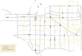
Item is a map composed of a base map and a mylar overlay. Base map shows zoning districts, streets, schools, parks, and golf courses, and includes a table of building lines as contained in Schedule "E" to By-law no. 3575. The Mylar overlay shows arterial roads, collector roads, and retail frontage.


![Zoning map : City of Vancouver, British Columbia [front side]](/uploads/r/null/d/f/df6282b6329852b263c3d33e20d903e4289eec05fde21bd58597f62d30789dde/225b2095-0e64-4986-878c-fd99eb6e1f18-PD2100_142.jpg)
![Zoning map : City of Vancouver, British Columbia [verso]](/uploads/r/null/8/e/8e44e80ba947d96b0a59a2bf4a48b60a1421fd04ba8480ddd13d7d13d0702e36/6b887f4f-8b76-48e2-866b-15499f569972-PD2100_142.jpg)
![Zoning map : City of Vancouver, British Columbia [front side]](/uploads/r/null/c/6/c61049cff53ecb5ec71dcc9b9de797d324126efb9c99b5eb62ea91c42d3b6842/743a013c-68a0-418f-8c6a-fd776aa116ef-PD2100_142.jpg)
![Zoning map : City of Vancouver, British Columbia [verso]](/uploads/r/null/0/c/0c28eac99426ce4ba64e4dfd48e45082c152014d6316047710a9601978663e70/d7052696-ccd5-4643-98d6-5e29205d9903-PD2100_142.jpg)
