![[Andy Linton]](/uploads/r/null/0/d/7/0d7b002f4af35b8e53a341fab534ec36657ba734011f1ef94eb3f0f4bd74b6ce/0f2d597a-85a1-4209-b79c-2a570295a31f-CVA371-1685_142.jpg)
- AM54-S4-2-: CVA 371-1685
- Item
- [ca. 1930]
Part of Major Matthews collection
9835 results with digital objects Show results with digital objects
Part of Major Matthews collection

Part of Major Matthews collection
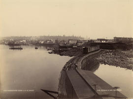
Photograph shows a southwest view from Hastings Sawmill wharf
![[Looking north near Centre (Granville) Street from Ninth Avenue (Broadway)]](/uploads/r/null/c/e/4/ce4ffc7a415fa319989924880d1cd2c38f405330b79a6dc2d05f1b73b95584dc/0dc120d9-b165-430a-a51b-6aaf5329df24-CVA371-1477_142.jpg)
[Looking north near Centre (Granville) Street from Ninth Avenue (Broadway)]
Part of Major Matthews collection

Part of Major Matthews collection
Item is a photographic copy of a telegram

Part of Major Matthews collection
Item is a photographic copy of a handwritten formal greeting, with a drawn border

Greetings from "The Birds Paradise" Vancouver, B.C.
Part of Major Matthews collection
Photograph shows "Smoky". This is a cropped version of CVA 371-1192
![["Smoky" sits with the birds at Charles E. Jones Birds' Paradise]](/uploads/r/null/6/c/5/6c506100433d18b70c71e292ec0c4a5d23adbb28ca53ed738991bb685449a9d8/93be23a4-0aae-4de4-bd7a-a1b1301a6239-CVA371-1380_142.jpg)
["Smoky" sits with the birds at Charles E. Jones Birds' Paradise]
Part of Major Matthews collection

Greetings from The Birds' Paradise, Vancouver, B.C.
Part of Major Matthews collection
Photograph shows Charles E. Jones
![[Charles E. Jones' dog "Smoky"]](/uploads/r/null/2/2/d/22dc2ed179d0cba3b99f2ba7d39c2bccc6f4b75017d73f66dcbdf3d4791979b7/cd005e4a-2c5c-4ed4-a0cc-38fe35e6b036-CVA371-1272_142.jpg)
[Charles E. Jones' dog "Smoky"]
Part of Major Matthews collection
![[Cordova Street looking west from Carrall Street]](/uploads/r/null/2/a/3/2a3d21e3af3e2e85d0cf2207073f1924b9cb97f602b6dd55da2a4faee2693230/9b8051d7-2e39-42ec-b77b-929e8483001a-CVA371-1216_142.jpg)
[Cordova Street looking west from Carrall Street]
Part of Major Matthews collection
Photograph shows the Dunn-Miller Block
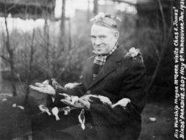
His Worship Mayor McGeer visits Chas. E. Jones' Birds' Paradise - 5207 Hoy Street
Part of Major Matthews collection
![[View from Hastings Street looking east towards Hastings Sawmill]](/uploads/r/null/8/d/1/8d1a8490286845ff5981f4e13ca37018dadd1ba67f6ef483a2cbbd775a0f262c/a94b38cb-9e2b-4924-be6f-ab1acaf86711-CVA371-1177_142.jpg)
[View from Hastings Street looking east towards Hastings Sawmill]
Part of Major Matthews collection
Panoramic view from the Lefevre Block showing the C.P.R. offices on Cordova Street and the roof of the Wulffsohn Block

Part of Major Matthews collection

Part of Major Matthews collection
Photograph shows the exterior of the following schools (and the number of rooms in each one): Mount Pleasant, Strathcona, Vancouver High School, Fairview, Dawson, Seymour, Roberts and Central
![[Miss Mary Maddams]](/uploads/r/null/5/6/8/56887ab08169ca2f01359d8c10c5ca06974f14d1df18d668912baaeac9315ce9/1bfa831e-6c5c-41ff-b280-5ccbb9b7ca79-CVA371-1089_142.jpg)
Part of Major Matthews collection

A proposal for a west end Civic Centre by George Thompson
Part of Major Matthews collection
Item is a photograph of a plan

Part of Major Matthews collection
Item is a photograph showing shows Major J.S. Matthews, Mrs. Jean G. Gibbs and Principal Muir. Notes written on the back include: "Sir Charles Kingsford Smith School, Vancouver. 8901 Elliott St. On June 24th 1959, at 2 30 p.m., there was unveiled at this school, and, in the presence of Miss Florence Fyfe-Smith, Principal Muir, of the school, Major J.S. Matthews, City Archivist, and Mrs Jean G. Gibbs, Assistant Archivist, a photogravure of an oil painting of the celebrated aviators, Charles Kingsford Smith, and Captain Ulm, who together were the first to fly from America to Australia. The painting was painted for the Atlantic Union Oil Co., of Australia, by William Dargie. Major Matthews arranged with Mr McDermot, Canadian High Commissioner, Canberra, for colored copies. Mr McDermot sent about six. One is in the City Archives. There were about 600 pupils at the ceremony."

Elevation sketch of Seaforth Armoury
Part of Major Matthews collection
Item is a photograph of an elevation sketch by McCarter and Nairne structural engineers.
![[Interior of the Shelly (Duncan) Building at 119 West Pender Street]](/uploads/r/null/1/5/e/15e3cf22d651c5657f14a25539f9720e1167d98cb9e45b4236e711b0f226c79d/bbc26d8c-81ce-4820-acb9-480f531793ce-CVA371-864_142.jpg)
[Interior of the Shelly (Duncan) Building at 119 West Pender Street]
Part of Major Matthews collection
Photograph shows the lobby
![[Exterior of the Shelly (Duncan) Building at 119 West Pender Street]](/uploads/r/null/e/7/d/e7d3d3697235cffe153508af8b5d9566d87be2ce82897edb5167f625ce5ffcb5/257357f3-e93f-4598-bbb6-f051174da221-CVA371-864_142.jpg)
[Exterior of the Shelly (Duncan) Building at 119 West Pender Street]
Part of Major Matthews collection
![[Sales information about the Shelly (Duncan) Building at 119 West Pender Street]](/uploads/r/null/8/a/4/8a45bc5a9351da301fece1e796375338a40b61235a7a018380e46d0de1c00056/9de9538a-0397-405a-b192-6f035fbaf116-CVA371-863_142.jpg)
[Sales information about the Shelly (Duncan) Building at 119 West Pender Street]
Part of Major Matthews collection

Part of Major Matthews collection
J.S. Matthews' notes with print or negative in Archives.
Part of Major Matthews collection
J.S. Matthews' notes with print or negative in Archives.
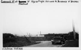
![[View of partially constructed Burrard Street Bridge from Cornwall Street and Chestnut Street]](/uploads/r/null/8/3/9/8399ecdf349ef8db8781a0225e88127a749b80365d37b4878d5add93772b0baa/f023789c-de44-4a57-a591-1efa3c748ea4-CVA371-853_142.jpg)
[View of partially constructed Burrard Street Bridge from Cornwall Street and Chestnut Street]
Part of Major Matthews collection
J.S. Matthews' notes with print or negative in Archives.

Vancouver, B.C. from Deck of Incoming Steamer
Part of Major Matthews collection
![[View of the Vancouver waterfront]](/uploads/r/null/1/d/4/1d48c974d803427210167c943280e8c745c1079a372a8128ed0a7d93b8a877e1/a744aeb8-feb3-4d15-9373-c59861cb8235-CVA371-830_142.jpg)
[View of the Vancouver waterfront]
Part of Major Matthews collection
![[View of Cedar Street (Burrard Street), looking south from 1st Avenue]](/uploads/r/null/5/4/6/546bde6574cf2d5e2d523addd9591e1710627187bd04c3d93cb181a8630c2230/a0010462-bb2d-4682-af2b-e493c71a1bdd-CVA371-817_142.jpg)
[View of Cedar Street (Burrard Street), looking south from 1st Avenue]
Part of Major Matthews collection
J.S. Matthews' notes with print or negative in Archives.
![[View of Cedar Street (Burrard Street), looking north from 1st Avenue]](/uploads/r/null/9/5/1/951361df52bc39caa119f27dbb826caa9f8321d69bffb9d534bf12ba32aa9705/36b8f243-7cb9-4ced-b859-5c83a7f4b85b-CVA371-816_142.jpg)
[View of Cedar Street (Burrard Street), looking north from 1st Avenue]
Part of Major Matthews collection
J.S. Matthews' notes with print or negative in Archives.
![[View of Cornwall and Cypress Streets near entrance to Burrard Street Bridge]](/uploads/r/null/8/6/d/86dac76ad8cb724cd7224e11a833da97224b6b85e5d0a9820f2a72347779b95d/28b56d29-93a3-4728-8ca0-db35bb4c412d-CVA371-815_142.jpg)
[View of Cornwall and Cypress Streets near entrance to Burrard Street Bridge]
Part of Major Matthews collection
J.S. Matthews' notes with print or negative in Archives.
![[View of Kingsway looking east from Slocan Street]](/uploads/r/null/5/3/8/538bef10d8f9525379c886d8f11cbe174269af436656e5528912805ae68083a6/a48926da-86d5-47c9-b715-e358d64c89db-CVA371-813_142.jpg)
[View of Kingsway looking east from Slocan Street]
Part of Major Matthews collection
![High School sports [girls' track team]](/uploads/r/null/d/5/c/d5cc6b7166ac3792493a70fe9612633e63931ec40dde67abe0aa3c9f300a2ee8/693bc65b-7df1-4590-88a2-31db8cafa7a0-CVA371-803_142.jpg)
High School sports [girls' track team]
Part of Major Matthews collection
Group portrait showing June McFarlane, Dorothy Paulin, Aileen Curran, Mary Code, Jean Bowman, Margaret Wright and others
![[Portrait of Mrs. Alice Crakanthorp]](/uploads/r/null/b/4/b/b4b33373ef6d01f28ce30697c5d6eeaec4c4628a632eb9b2175aca0c07b2a907/2dd9cdd8-d933-4cd0-b536-adcb25db9c9b-CVA371-716_142.jpg)
[Portrait of Mrs. Alice Crakanthorp]
Part of Major Matthews collection
Photograph shows Mrs. Crakanthorp, nee Patterson, seated on a sofa. In 1943, Mrs. Crakanthorp was the sole surviving pupil of the first class of Hastings Sawmill School.
![[British warship at dock in Vancouver]](/uploads/r/null/d/6/1/d61c8cf19f66b542d3db72ea8f1293b4d492143b74126f9de46b65ff8aaf4094/174037cf-3c89-4dff-a2f1-2b2b35739a4d-CVA371-458_142.jpg)
[British warship at dock in Vancouver]
Part of Major Matthews collection
Written on the back "Vancouver. Think June 29, 1898"
![[Crowds at C.P.R. station viewing the arrival of the] first train in Vancouver](/uploads/r/null/7/4/5/74581a27127fa7d8c72e9840c2caefa7c5de7b6006656f26f9a607644bf38bea/b0320be2-9157-47dd-a688-2d35c3f55dad-CVA371-454_142.jpg)
[Crowds at C.P.R. station viewing the arrival of the] first train in Vancouver
Part of Major Matthews collection
J.S. Matthews' notes with print or negative in Archives.

Arrival of their Royal Highness Duke and Duchess of Connaught, Vancouver May 22nd, 1890
Part of Major Matthews collection
Ships identified (left to right) S.S. "Islander" and C.P.R. Royal Mail S.S. "Abyssinia"
![[A photograph by Bailey Bros. of Park Road at Stanley Park displayed on an easel]](/uploads/r/null/b/9/8/b985c28878d9263c0aeca5127841588d959266db3b09fb0b0ae156338d807217/91cfb752-a7ba-4e67-9797-367154f960a7-CVA371-363_142.jpg)
[A photograph by Bailey Bros. of Park Road at Stanley Park displayed on an easel]
Part of Major Matthews collection
![[A hull under construction at West Coast Shipbuilders Limited]](/uploads/r/null/d/a/8/da87e4b15a400a644641607a71628dc263cbfc7944a75579da058b0700a82287/9796e951-7b9f-4d97-9379-7a9e51ce9d5c-CVA371-237_142.jpg)
[A hull under construction at West Coast Shipbuilders Limited]
Part of Major Matthews collection

Capt. G.R. Bates, Air raid Precaution Controller, North Vancouver and District
Part of Major Matthews collection
Item is a photograph of a painting. Description written on the back of the photograph is: "Painted by Nesta Bowen Horne at instance of Citizens Committee. Unveiled by His Worship Jack Loutet, Nov. 15, 1945. Hung in City hall, North Vancouver."
Moore, W.J.
![[Major General John Peter Mackenzie]](/uploads/r/null/4/a/b/4ab7bf8041ef0991f72297f549031beae49219d3f3118064bc4c0037ecdaea64/98238c11-3e35-4ba7-8147-34dd52750fcb-CVA371-147_142.jpg)
[Major General John Peter Mackenzie]
Part of Major Matthews collection
Item is a photograph. Notes are written on the back. Head and shoulders portrait

Cordova Street, Vancouver, B.C.
Part of Major Matthews collection
Photograph shows a view looking west from Carrall Street showing the Dunn-Miller Block

Part of Major Matthews collection
Item is a photograph of a painting of the scene depicted in the image with the identifier SGN 155.

Letter from Burrard Dry Dock Company to Major Matthews regarding a photograph
Part of Major Matthews collection
Item is a letter from Burrard Dry Dock Company (previously Wallace Shipyards) regarding the location of a photograph.
Part of Major Matthews collection
![[Panoramic view looking north from the Hotel Vancouver]](/uploads/r/null/d/0/3/d032ae1a08ec1b68763941336f6a07708bf678235ae8cdf506cbbdc3fb10451d/98ea51ff-abce-48a9-9401-16834b8ba6a4-VanScP143_142.jpg)
[Panoramic view looking north from the Hotel Vancouver]
Part of Major Matthews collection
Photographs show the west side of the 600 Block of Howe Street, Manor House, Deadman's Island, the 600 Block of Granville Street, the Van Horne Block, the Hudson Bay Company store, the Homer Street Methodist Church, the tower of Holy Rosary Cathedral and other buildings and houses

Our Schools - Mount Pleasant, High, Strathcona, Fairview, Dawson, Seymour, Central, Roberts
Part of Major Matthews collection
![[Northward view of Hastings Townsite]](/uploads/r/null/1/e/3/1e37fe922b4e9f7365f7b0c0b8b7faa4e1bf8c9e14bdc4a620ea91e77eb41e48/8fedc54a-7fcc-41b9-bd17-ed0a01f0a9bb-PANP94_142.jpg)
[Northward view of Hastings Townsite]
Part of Major Matthews collection
Photograph shows the Powell St. street car tracks, houses and Hastings Mill and Store. Scan cut off top portion of the sky and annotations.
Part of Major Matthews collection
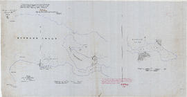
Item consists of a tracing of two maps on one sheet, of a map most likely originally drawn in 1859 or 1860. Based on the copied annotations, this tracing appears to be at least a second (or possibly third) generation tracing from the original map created as a result of the H.M.S. Plumper surveys of the area at that time.
One map shows Burrard Inlet, Point Grey, Spanish Bank [sic], Point Atkinson, English Bay, Downtown Peninsula, Coal Peninsula, Brockton Point, First Narrows and False Creek, and proposed government land reserves in these areas. The second map shows Burrard Inlet and Port Moody and proposed government land reserves in this area.

Uncontrolled Mosaic of South Vancouver, B.C.
Part of Major Matthews collection
Aerial view showing Mitchell Island and the area between approximately Knight Street, Kerr Street (Rupert Street), the Fraser River and 12th Avenue
![[Major Matthews with cane]](/uploads/r/null/1/6/2/1623f070d0d25febd5da74e61b77e367b8f0040cd61a0e38eb01c4522e6c63fe/2945f363-c6f7-4342-a71d-2f5526ffb677-CVA371-3166_142.jpg)
Part of Major Matthews collection

View of Waterfront J. Coughlan and Sons, Limited Shipyards, Vancouver, B.C.
Part of Major Matthews collection
Panoramic view showing the slips, storage yards, S.S. "Canadian Inventor", S.S. "Canadian Explorer" and S.S. "Canadian Importer" at the foot of Columbia Street on False Creek