
City of Vancouver : land use 1984
- PUB-: PD 1984
- Item
- 1984
Part of City publications collection
Item is a map showing types of residential, commercial, industrial, and recreational land use in Vancouver.
City of Vancouver : land use 1984
Part of City publications collection
Item is a map showing types of residential, commercial, industrial, and recreational land use in Vancouver.

Official Regional Plan : proposed amendments within the City of Vancouver
Part of City publications collection
Item is a map showing proposed amendments to industrial and rural zoning areas.

Part of City publications collection
Item is a map showing proposed commercial and residential zones and the location of an elementary school in the area directly south of Simon Fraser University. Base map shows land use for the area bounded by Willingdon Avenue, North Road, Barnet Road, and the Trans-Canada Highway.

Part of City publications collection

Preliminary report on civic centre
Part of City publications collection
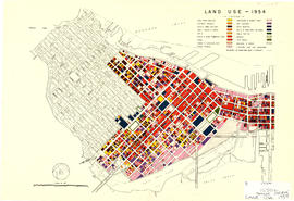
Part of City publications collection
Item is a map showing land use for single family, two family. and multiple family dwellings, tourist courts and cabins, hotels, offices and other commercial uses, stores, parking and commercial lots, service stations, warehouses and storage yards, light industrial, heavy industrial, public and semi-public buildings, public utilities, schools, open spaces, and railroads and docks.