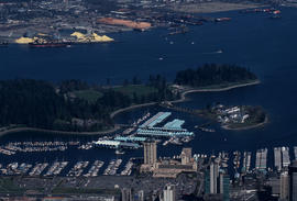
![[Northwest facing cityscape view of the West End]](/uploads/r/null/8/1/8144b464121d2d606915a295fe4bfea95b903893f4ac909e59d22d27b3a6c7db/c58f4286-e96d-4189-ad75-9885f1b17ff7-A59249_142.jpg)
[Northwest facing cityscape view of the West End]
- COV-S511---: CVA 780-384
- Item
- 1966
Part of City of Vancouver fonds
Photograph also shows buildings in the West End, English Bay, Stanley Park, Coal Harbour, Burrard Inlet, and the North Shore
[Northwest facing cityscape view of the West End]
Part of City of Vancouver fonds
Photograph also shows buildings in the West End, English Bay, Stanley Park, Coal Harbour, Burrard Inlet, and the North Shore
![[Coal Harbour?]](/uploads/r/null/d/b/db2de6c93437b31527635deddfa2d1b0228f1dfd0d78c0bf6d754fd685fc663b/dccf9129-e23d-46e6-8e3f-0adde1d833b8-A16628_142.jpg)
Part of City of Vancouver fonds
Photograph shows marsh and water with gazebo in background.
![[Coal Harbour?]](/uploads/r/null/1/0/10b1e3b62444e17b20e5c87b9cb37773568bcad1eb9f6ef2efd8c228b7f06408/5aa04f62-7a7b-4a73-a8bf-7920b9573446-A16631_142.jpg)
Part of City of Vancouver fonds
Photograph shows marsh, water and bridge.
Part of City of Vancouver fonds
Item is a documentary film documenting the transportation and population issues that impact access to downtown Vancouver. Film contains scenes of driving on the Granville Street Bridge, people attending a show, on a beach and walking around city streets at both daytime and evening.
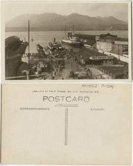
Looking N across harbour, Vancouver, B.C.
Item is a postcard printed with an image of the North Vancouver ferry dock in Vancouver Harbour. Passengers on foot and in cars are pictured disembarking from a ferry. The Grand Trunk Pacific Railway dock is also shown; a steamship is moored on its west side. North Vancouver is visible in the distance.

Item is a photograph of a high angle view looking northeast over the C.P.R. train tracks at Vancouver Harbour.

No. 1053, Burrard Inlet, Vancouver, B.C.
Item is a postcard showing the Burrard Inlet. The back of the postcard includes personal correspondence.
![[Coal Harbour]](/uploads/r/null/7/7/77cafdf979fc613841ced240338b064a0d12d9e69c44cdbc458b83707b742e85/c32a0c26-2ba0-446c-bdac-ea9cff6ffa7a-A71815_142.jpg)

Bird's Eye View - Vancouver Harbour B.C. Proposed Kitsilano Terminal and Free Port
Item is a mounted photographic copy of an aerial oblique perspective drawing of a proposed terminal and port facility located, but never built, at Kitsilano Point, Vancouver, B.C.

Empress of China at dock, 1906, Vancouver, B.C.

The Harbour Mouth from Common, Looe
This postcard includes personal correspondence addressed to Edwin Baggs of Vancouver.

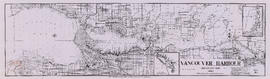
Vancouver Harbour : Sheet 3 (Second Narrows to Port Moody)
Part of City of Vancouver Archives technical and cartographic drawing collection
Item is a nautical chart of Vancouver Harbour from Second Narrows in the west to Port Moody in the east, showing soundings in fathoms, tidal information, anchorages, beacons, and waterfront businesses. Street names are shown on land areas.
Vancouver Harbour, British Columbia, 1964
Part of City of Vancouver Archives technical and cartographic drawing collection
Item is a nautical chart showing English Bay and Burrard Inlet with soundings in feet, anchorages, locations of submarine cables, and ferry lines. Land features include city blocks and district lot numbers. Includes inset maps of the North Arm of Burrard Inlet and Vancouver Island.

First Narrows, Burrard Inlet, B.C. showing Parthia and Burnaby shoals
Part of City of Vancouver Archives technical and cartographic drawing collection
Item is a map showing shorelines, estuaries of adjacent creeks, mud flats, tide levels and soundings in feet. Map notes velocity of current at First Narrows.
New Westminster (B.C.). Department of Public Works
Stanley Park, the VanDusen Garden, and the visit of the Kaiwo Maru
Part of City of Vancouver Archives sound recording and moving image collection
Item is a documentary film documenting Stanley Park, the VanDusen Botanical Display Garden, and the visit to Vancouver of the Japanese tall ship the Kaiwo Maru. Footage taken at the VanDusen Garden includes the garden entrance, the administration/library/classroom building, flower beds, roses, trees, ponds, lily pads, blue herons, a starling, and stone sculptures. Footage from Stanley Park includes crowds at the Stanley Park Junction, children and adults riding the Stanley Park Miniature Railway, people watching bears at the Stanley Park Zoo, and other zoo animals including flamingoes and seals. Film also includes footage taken from a sail boat of the Kaiwo Maru in English Bay surrounded by numerous pleasurecraft, with a group of the Kaiwo Maru's crew standing on her bow. The film also includes footage of Vancouver Harbour, downtown Vancouver, and cruise ships at berth as viewed from the deck of a sail boat.
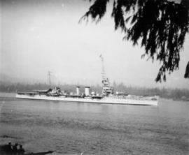
![HMS Hood at Vancouver [British warship in Vancouver Harbour on its Empire Tour]](/uploads/r/null/0/3/030e660a230121de6197a93d162bbe32e3b023da133be31d865d1ce8acf4208f/268a806f-d8cb-480f-b1ea-b7c75162b339-A49461_142.jpg)
HMS Hood at Vancouver [British warship in Vancouver Harbour on its Empire Tour]
Part of H.A. Price collection
Photograph shows HMS Hood at anchor in Vancouver Harbour. Vancouver was a port-of-call on the Hood's round-the-world Empire Tour.
![HMS Hood at Vancouver Liberty boat [Naval steam launch in Vancouver Harbour with passengers]](/uploads/r/null/e/6/e6d94ae19fe180c707b514e7e79d508c51794590f6e43392beed4b11c24678a9/26a69a5a-3181-4689-b3d0-dca774903bdd-A49462_142.jpg)
HMS Hood at Vancouver Liberty boat [Naval steam launch in Vancouver Harbour with passengers]
Part of H.A. Price collection
Photograph shows naval steam launch with civilian passengers in Vancouver Harbour.

Part of Hubert William Lovell fonds
Photograph was taken in the summer.

Eagle Harbour, old logging buildings
Part of Hubert William Lovell fonds
Photograph was taken in the summer.

Part of James Crookall fonds
![[View of Vancouver Harbour]](/uploads/r/null/a/0/a0fce588a79be42430d0804a0fd716a8b7f75659abdc5d0bdda3fb6d0037a9d2/d31e0dfb-2197-47d3-9af5-ddbf27174a75-A76378_142.jpg)
Part of James Crookall fonds
![Inner harbour [showing] small boats and Union Steamship's "Camosun"](/uploads/r/null/8/3/8303cd242ec78fef75e71bafde482f07bd2b430499cc36c71ed69464e42db9b8/44299432-4d2b-4077-a737-f3e87866a9e9-A76340_142.jpg)
Inner harbour [showing] small boats and Union Steamship's "Camosun"
Part of James Crookall fonds

Part of James Luke Quiney fonds
![N.P.A.A.O. [North Pacific Association of Amateur Oarsmen. Four-man sculls at] Esquimalt](/uploads/r/null/3/9/9/39987f37873391a1c3f2c8d1a3117b3b780fd35f99916cea9c357f5094bb1227/15ea02ff-5b9a-4e86-9d07-ac6d7e360763-CVA7-317_142.jpg)
N.P.A.A.O. [North Pacific Association of Amateur Oarsmen. Four-man sculls at] Esquimalt
Part of James Luke Quiney fonds

R.M.S. "Empress of Russia" in Vancouver Harbour
Part of John William Freeston fonds
Panoramic view showing Burrard Inlet, the Immigration Building, C.P.R. Pier A, C.P.R. Pier D, Pier B-C construction site and Deadmans Island, Coal Harbour, Brockton Point and the Lions in the background

'Greenhill Park' ship explosion in Vancouver Harbour

Showing Entrance to Stanley Park looking East
Part of Stuart Thomson fonds
Oblique view showing Lost Lagoon, Coal Harbour, Deadman's Island, Brockton Point, Denman Arena, the Horseshow Building and Downtown in the background
!["Empress of Canada" [entering Burrard Inlet]](/uploads/r/null/9/4/94db9b96ed1cf51e6d7cc1d562628787707c23a528f090ccf8ee512396aed7a9/98f3b35c-e49f-42fa-a34d-9eb96318eda1-A00283_142.jpg)
"Empress of Canada" [entering Burrard Inlet]
Part of Stuart Thomson fonds
!["Empress of Canada" [entering Burrard Inlet]](/uploads/r/null/e/a/ea0c5910328c32658de02132a7a00d337a0995e4661e1e0c691882bef81b2912/7ef44123-7779-4370-abde-3644353aedd5-A00284_142.jpg)
"Empress of Canada" [entering Burrard Inlet]
Part of Stuart Thomson fonds
![[Boats at anchor in island harbour]](/uploads/r/null/2/6/262e645a55bba35432f103ba74274d794b9e4719d5af2c4da74ef4ab47a0a480/f751b479-05ba-4cb3-86fb-412bd9ad655c-A16054_142.jpg)
[Boats at anchor in island harbour]
Part of Stuart Thomson fonds
![[H.M.S. "Despatch" entering harbour]](/uploads/r/null/1/8/18ce4750915c44f96eed5d8729614fe7b08a4a4bd28a472ad38e3c2c93688995/bcc38b44-f22b-4887-8576-c32d863ce3b9-A00137_142.jpg)
[H.M.S. "Despatch" entering harbour]
Part of Stuart Thomson fonds
![[H.M.S. "Hood" starboard stern quarter view - entering harbour]](/uploads/r/null/5/5/55e99a9296d9c275bbc4443d7a6d261a59588ace6c454bc0a74a38b2a95ccddd/c34e48ca-fd69-49ba-9389-3fba558fe6a9-A16027_142.jpg)
[H.M.S. "Hood" starboard stern quarter view - entering harbour]
Part of Stuart Thomson fonds
![[Ship docking at wharf - Pender Harbour - Union Steamship Co.]](/uploads/r/null/4/2/425618008e4efb7299c2870f60339c81c383d1885d9b88eb60ad614fd7065cc3/a9d39b1b-a4e5-41f3-a08b-331797367920-A01746_142.jpg)
[Ship docking at wharf - Pender Harbour - Union Steamship Co.]
Part of Stuart Thomson fonds
Item is a photograph showing the vessel, "Lady Cecilia."


Visit of H.M.S Durbain, Despatch, and H.M.C.S Vancouver
Part of Stuart Thomson fonds
Ship - possibly H.M.S. Despatch
Part of Stuart Thomson fonds
![[Dredging] drill](/uploads/r/null/8/b/8bb6d6caa508ebafbe54a8a3d3a65f79ffaadd1478574fd193f15aa473444465/64564f45-3036-423d-a547-db9887092a15-A31773_142.jpg)
Part of Major Matthews collection

East half Granville Island before filling
Part of Major Matthews collection
Photograph shows harbour, log boom and wharves.
![Filling of government dock at Victoria, B.C. [Victoria outer dock]](/uploads/r/null/a/4/a407ab35e25717806ed19dee13e037e030e5e4a94cee438b0b27b6b923de43ce/82cdb86b-0638-46f6-8815-f9a538f91041-A31776_142.jpg)
Filling of government dock at Victoria, B.C. [Victoria outer dock]
Part of Major Matthews collection
![[Coal Harbour, showing part of Stanley Park, Deadman's Island, and houseboats]](/uploads/r/null/1/2/12067ca2ea5ea0ff39ee45868194a05deff43c7c02b79dc9558e8710362bcd57/cc755324-9751-4940-ac1f-281c8e8867e0-A02323_142.jpg)
[Coal Harbour, showing part of Stanley Park, Deadman's Island, and houseboats]
![[View of Coal Harbour from Vancouver]](/uploads/r/null/a/d/ad3804d91a35387f53f4c5858b7f68b9c622339a85523df7f8917001ab7d3c74/187cecca-d78f-4911-826f-3d952d4df917-A01985_142.jpg)
[View of Coal Harbour from Vancouver]
Photograph shows part of Vancouver waterfront, Coal Harbour, Deadman's Island, and Stanley Park.
![[Boats in] Coal Harbour](/uploads/r/null/4/e/4e0ce74158796911dcd444ae208a0139e91a4251c536cf44042cbf4336ab4be4/9190958d-05ac-45a7-ae92-6df410a7bab9-A01926_142.jpg)
Photograph shows various types of boats in the harbour, with Stanley Park in the background.
![Mr. G.B. Warren, Pacific Motor Boat, loading yachts on scow [False Creek South]](/uploads/r/null/3/d/3d64427c867440e7d963d876580d7a96d4e51be7df567c1fc70173c55e3642d4/bca9a4db-6ce1-43f2-a5a9-4093881390a7-A01560_142.jpg)
Mr. G.B. Warren, Pacific Motor Boat, loading yachts on scow [False Creek South]
Part of Stuart Thomson fonds
![Mr. G.B. Warren, Pacific Motor Boat, loading yachts on scow [False Creek]](/uploads/r/null/3/d/3de4a6c7f897b524e96125c76b31a4f9cc8f0fdb760b732c70e777151e599f8e/538827c0-3fdd-4563-8064-633ec45e13e4-A01561_142.jpg)
Mr. G.B. Warren, Pacific Motor Boat, loading yachts on scow [False Creek]
Part of Stuart Thomson fonds
Imperial Gasoline signboard in background.

Freighter "Ixion" and C.P.R.'s "Princess Mary" leaving harbour
Part of Stuart Thomson fonds
![H.M.S. "Despatch" [entering harbour]](/uploads/r/null/2/0/20afef54e8128e932c37191668c9cbc154892daca2f158b2cbb34d319306aa6e/e3887beb-99d6-4cc4-a2da-0c35ea04bea8-A00144_142.jpg)
H.M.S. "Despatch" [entering harbour]
Part of Stuart Thomson fonds
![Indian dugout canoe on Burrard Inlet [harbour]](/uploads/r/null/7/7/775d758e1bb5c348a41e670946ce0a65b2556d80102d0ff66d677947ce517c41/ffc98d9f-ed73-49b3-9db7-0d1a937af62c-A00789_142.jpg)
Indian dugout canoe on Burrard Inlet [harbour]
Part of Stuart Thomson fonds

Canadian National Railways steamship "Prince Robert" leaving harbour
Part of Stuart Thomson fonds

Royal Navy vessel entering Burrard Inlet
Part of Stuart Thomson fonds