- COV-S280-: CVA 354-094
- Item
- Apr. 21, 1930
Part of City of Vancouver fonds
6048 results with digital objects Show results with digital objects
Part of City of Vancouver fonds
Part of City of Vancouver fonds

Sheet 10 : Clark Drive to Slocan Street and Burrard Inlet to Triumph Street
Part of City of Vancouver fonds
Item is a section showing the area from Clark Drive to Slocan Street and aterfront to Triumph Street. Includes streets and roads, blocks, lots, legal descriptions, railways, parks, boys' detention home and businesses along the waterfront. The Town of Hastings is indicated on the map. Map is hand coloured to show tax sale property for sale, property with no water, street widening and drainage, replotting, reserved land for schools, reserved land for parks, sundry land, capital assets not including schools and parks, schools, and parks, as applicable.
Vancouver (B.C.). Office of the City Engineer

Sheet 8 : McLean Drive to Slocan Street and William Street to Seventh Avenue
Part of City of Vancouver fonds
Item is a section showing the area from McLean Drive to Slocan Street and William Street to Seventh Avenue. Includes streets and roads, blocks, lots, legal descriptions, railways, parks, schools and some businesses. Map is hand coloured to show tax sale property for sale, property with no water, street widening and drainage, replotting, reserved land for schools, reserved land for parks, sundry land, capital assets not including schools and parks, schools, and parks, as applicable. Some annotations have been made in pencil.
Vancouver (B.C.). Office of the City Engineer

Sheet 16 : Maple Street to Oak Street and False Creek to Sixteenth Avenue
Part of City of Vancouver fonds
Item is a section showing Maple Street to Oak Street and False Creek to Sixteenth Avenue. Includes streets and roads, blocks, lots, legal descriptions, railways, schools and parks. Indicates crown land leased to the C.P.R. and other bodies. Map is hand coloured to show tax sale property for sale, property with no water, street widening and drainage, replotting, reserved land for schools, reserved land for parks, sundry land, capital assets not including schools and parks, schools, and parks.
Vancouver (B.C.). Office of the City Engineer

Sheet 18 : Trutch Street to Maple Street and English Bay to Third Avenue
Part of City of Vancouver fonds
Item is a section showing Trutch Street to Maple Street and English Bay to Third Avenue. Includes streets, roads, blocks, lots, legal descriptions, parks and crown grants. Map is hand coloured to show tax sale property for sale, property with no water, street widening and drainage, replotting, reserved land for schools, reserved land for parks, sundry land, capital assets not including schools and parks, schools, and parks.
Vancouver (B.C.). Office of the City Engineer

Sheet 21 : Burrard Street to False Creek and waterfront to Robson Street
Part of City of Vancouver fonds
Item is a section showing Burrard Street to False Creek and waterfront to Robson Street. Includes streets and roads; blocks, lots and legal descriptions; the locations of hotels, court house, businesses, parks, and schools; crown leases; C.P.R. land and the company's Piers B and C, yards, sheds and depot; the B.C. Electric Railway Carrall Street Yard; and the Union Steamship Company. Map is hand coloured to show tax sale property for sale, property with no water, street widening and drainage, replotting, reserved land for schools, reserved land for parks, sundry land, capital assets not including schools and parks, schools, and parks, as applicable.
Vancouver (B.C.). Office of the City Engineer

Sheet 6 : Knight Street to Slocan Street and Eighteenth Avenue to Twenty-ninth Avenue
Part of City of Vancouver fonds
Item is a section showing the area from Knight Street to Slocan Street and Eighteenth Avenue to Twenty-ninth Avenue. Includes streets and roads, blocks, lots, legal descriptions, railways, parks and schools. Some annotations have been made in pencil. Map is hand coloured to show tax sale property for sale, property with no water, street widening and drainage, replotting, reserved land for schools, reserved land for parks, sundry land, capital assets not including schools and parks, schools, and parks. Map is hand coloured to show tax sale property for sale, property with no water, street widening and drainage, replotting, reserved land for schools, reserved land for parks, sundry land, capital assets not including schools and parks, schools, and parks, as applicable.
Vancouver (B.C.). Office of the City Engineer

Sheet D : Imperial Street to Trutch Street and Fourth Avenue to Sixteenth Avenue
Part of City of Vancouver fonds
Item is a section showing the area from Imperial Street to Trutch Street and Fourth Avenue to Sixteenth Avenue. Includes streets and roads; blocks; lots and legal descriptions; and parks, schools and golf courses. Section is annotated to show tax sale property for sale, property with no water, street widening and drainage, replotting, reserved land for schools, reserved land for parks, sundry land, capital assets not including schools and parks, schools, and parks, as applicable.
Vancouver (B.C.). Office of the City Engineer

Sheet G : Trafalgar Street to Granville Street and Sixteenth Avenue to Nanton Avenue
Part of City of Vancouver fonds
Item is a section showing the area from Trafalgar Street to Granville Street and Sixteenth Avenue to Nanton Avenue. Includes streets, roads and sewers; blocks, lots and legal descriptions; and parks, railway lines and schools. Section is annotated to show tax sale property for sale, property with no water, street widening and drainage, replotting, reserved land for schools, reserved land for parks, sundry land, capital assets not including schools and parks, schools, and parks, as applicable.
Vancouver (B.C.). Office of the City Engineer

Sheet X : Marine Drive to Ash Street and Fifty-ninth Avenue to Seventy-first Avenue
Part of City of Vancouver fonds
Item is a section showing the area from Marine Drive to Ash Street and Fifty-ninth Avenue to Seventy-first Avenue. Includes streets and roads; blocks, lots and legal descriptions; and parks and schools. Map is hand coloured to show tax sale property for sale, property with no water, street widening and drainage, replotting, reserved land for schools, reserved land for parks, sundry land, capital assets not including schools and parks, schools, and parks, as applicable.

Sheet 6 : Craddock Street to Boundary Road and Twenty-ninth Avenue to Fortieth Avenue
Part of City of Vancouver fonds
Item is a section showing the area from Craddock Street to Boundary Road and Twenty-ninth Avenue to Fortieth Avenue. Includes streets, roads, blocks, lots, legal descriptions, parks. railway lines and schools. Map is hand coloured to show tax sale property for sale, property with no water, street widening and drainage, replotting, reserved land for schools, reserved land for parks, sundry land, capital assets not including schools and parks, schools, and parks, as applicable.
Vancouver (B.C.). Office of the City Engineer

Sheet 3 : Cambie Street to St. George Street and Twenty-seventh Avenue to Thirty-eighth Avenue
Part of City of Vancouver fonds
Item is a section showing the area from Cambie Street to St. George Street and Twenty-seventh Avenue to Thirty-eighth Avenue. Map shows streets, roads, blocks, lots and legal descriptions and the locations of parks, schools, reservoirs and Mountainview Cemetery. Map is hand coloured to show tax sale property for sale, property with no water, street widening and drainage, replotting, reserved land for schools, reserved land for parks, sundry land, capital assets not including schools and parks, schools, and parks, as applicable.
Vancouver (B.C.). Office of the City Engineer

Sheet 13 : Fleming Street to Carlton Street and Forty-seventh Avenue to Fifty-ninth Avenue
Part of City of Vancouver fonds
Item is a section showing the area from Fleming Street to Carlton Street and Forty-seventh Avenue to Fifty-ninth Avenue. Includes streets, roads, blocks, lots, legal descriptions, parks and schools. Map is hand coloured to show tax sale property for sale, property with no water, street widening and drainage, replotting, reserved land for schools, reserved land for parks, sundry land, capital assets not including schools and parks, schools, and parks, as applicable.
Vancouver (B.C.). Office of the City Engineer

Sheet 11 : Cambie Street to St. George Street and Forty-seventh Avenue to Fifty-eighth Avenue
Part of City of Vancouver fonds
Item is a section showing the area from Cambie Street to St. George Street and Forty-seventh Avenue to Fifty-eighth Avenue. Includes streets, roads, blocks, lots, legal descriptions, golf courses, parks and schools. Map is hand coloured to show tax sale property for sale, property with no water, street widening and drainage, replotting, reserved land for schools, reserved land for parks, sundry land, capital assets not including schools and parks, schools, and parks, as applicable.
Vancouver (B.C.). Office of the City Engineer

Sheet 9 : Fleming Street to Carlton Street and Thirty-seventh Avenue to Forty-eighth Avenue
Part of City of Vancouver fonds
Item is a section showing the area from Fleming Street to Carlton Street and Thirty-seventh Avenue to Forty-eighth Avenue. Includes streets, roads, blocks, lots, legal descriptions, parks and schools. Map is hand coloured to show tax sale property for sale, property with no water, street widening and drainage, replotting, reserved land for schools, reserved land for parks, sundry land, capital assets not including schools and parks, schools, and parks, as applicable.
Vancouver (B.C.). Office of the City Engineer

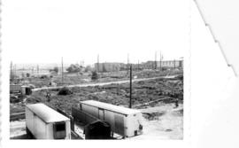
South west, south, and south east views from Hastings Viaduct
Part of City of Vancouver fonds
Item is a panoramic photograph showing south west, south, and south east views from the Hastings viaduct. On the left there is an arrow pointing to United Milling (feed and grain). Annotation on the back identifies the Manke Cabins on the right.

Part of City of Vancouver fonds
Item is a panoramic photograph showing the view across McLean Park to houses on the 400 block of East Georgia.
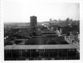
Old B.C. Electric Gas Plant from roof of McLean Park High-rise, looking east
Part of City of Vancouver fonds

New McLean park in foreground, 700 block Keefer in background
Part of City of Vancouver fonds

Part of City of Vancouver fonds
Item is a group of three photographs arranged vertically and affixed with tape. Annotation on top photo: "Rear of buildings in 400 block, Keefer Street." Annotation on middle photo: "East side of Burleith House." Annotation on bottom photo: "McLean Park High Rise in Background of Burleith House."
![The west end of Block 86 [Keefer Street - south side]](/uploads/r/null/7/1/8/718449a61ef28d000997ee1b4ee269fef37aabc4b15790ac496d415a6878035c/1751ccf4-5686-4608-93fb-1a3262368ccb-CVA181-22_142.jpg)
The west end of Block 86 [Keefer Street - south side]
Part of City of Vancouver fonds
Item is a photograph showing the west end of Block 86 (south side of Keefer Street). Stamp on back of photo: "Received by Property and Insurance Office, April 28, 1966".
Looking north towards Georgia Viaduct from Union Street
Part of City of Vancouver fonds
Looking south-west from Raymur Avenue
Part of City of Vancouver fonds

McLean Park with 700 Block Keefer in background
Part of City of Vancouver fonds
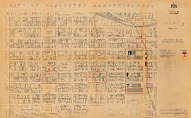
City of Vancouver redevelopment : project 1, area A-1 : City-owned land and buildings to be retained
Part of City of Vancouver fonds
Item is a map showing city-owned land, buildings in clearance areas to be retained, and boundaries of clearance areas. Base map shows streets, outlines of buildings, and topographic contour lines for the area from Main Street to Glen Drive and Alexander Street to Atlantic Street.

City of Vancouver redevelopment : project 1, area A-1 : detailed plan of redevelopment
Part of City of Vancouver fonds
Item is a map showing housing types, new streets and lanes, easements, and buildings to be retained as part of Project 1, and the boundaries of areas A1.1, A1.2, and A1.3. Base map shows streets, outlines of buildings, and topographic contour lines for the area from Main Street to Glen Drive and Alexander Street to Atlantic Street.

1000 block Nelson Street, Burrard-Thurlow, north side, view northwest
Part of City of Vancouver fonds

1200 block Nelson Street, Bute-Jervis, view west
Part of City of Vancouver fonds

1300 block Nelson Street, Jervis-Broughton, view southeast
Part of City of Vancouver fonds
1700 block Nelson Street, Bidwell-Denman, view east
Part of City of Vancouver fonds
![Cambie and 12th [Avenue] taken looking south west from the City Hall](/uploads/r/null/a/9/a95f8048b04d26c3060361b361c2b136bb58d850bbddd32cf9f2dc465086b275/92b1e557-98de-4bde-b1e7-944c3db510dd-A43707_142.jpg)
Cambie and 12th [Avenue] taken looking south west from the City Hall
Part of City of Vancouver fonds
Photograph shows the corner of the Imperial Oil gas station lot and the Blink Bonny apartments at 2825 Cambie Street and the house at 510 West 12th Avenue.
![[Granville Street at Robson Street, looking south]](/uploads/r/null/a/a/aa31b4fb329fc0a45fc4bf57eb1ba9577b8974130b3833b770e5a34f423e5bb2/67f9af08-68f0-415e-95e6-beed8a502406-A43709_142.jpg)
[Granville Street at Robson Street, looking south]
Part of City of Vancouver fonds
Photograph shows "Theatre Row".
![[Granville Street at Broadway, looking south]](/uploads/r/null/a/d/ad9fb3d4863318eb2af9936be53f2590f9885be4f79a66193f9ccc3f857a8c94/ad4447d5-b4e3-4378-a692-86d3e86a5a5f-A43711_142.jpg)
[Granville Street at Broadway, looking south]
Part of City of Vancouver fonds
Photograph shows the Aristocratic cafe and Jordans.
![[Granville Street at 11th Ave, looking south]](/uploads/r/null/b/0/b0b95d9b06cf45c97e2a41efb25abec88233f2d3fd8a49a08c95b8769c61bde4/7c7f2be8-6b05-439e-b609-a6224798fc49-A43713_142.jpg)
[Granville Street at 11th Ave, looking south]
Part of City of Vancouver fonds
Photograph shows the Stanley Theatre
![[One way traffic Seymour St. at Georgia Street, looking south]](/uploads/r/null/6/a/6ab5722dd80ce8659c50534737b97713ef7378106e8777583f6504275d6eb353/28fb7cc1-f428-4efb-9354-3631dfad7020-A43714_142.jpg)
[One way traffic Seymour St. at Georgia Street, looking south]
Part of City of Vancouver fonds
![[Seymour St. at Nelson St., looking east]](/uploads/r/null/6/7/674f17e26621bf88a01685886f3b90e9c81d8d4f7631a2430e620005b18466ff/7df56426-d3dd-4bfd-a460-566da7150ef1-A43720_142.jpg)
[Seymour St. at Nelson St., looking east]
Part of City of Vancouver fonds
Photograph shows Seymour Billiards.
![[800 E Hastings St]](/uploads/r/null/2/8/28ac1de86a0ec4e02f2ccaebd198f03b30e9d50715bfcf7843b57a82d6981417/14007932-5aa0-49f6-9caa-c7bb2c95c70a-A43722_142.jpg)
Part of City of Vancouver fonds
Photograph shows north side of the 800 Block of east Hastings Street as viewed from the southwest.
![[Hawkes Avenue at Hastings Street]](/uploads/r/null/4/3/4396259b55799a72f95a40de0cb3e84ce61fee05f34f430850ea64b1ae69c11b/d53216db-d489-4a3a-862e-f06decea401a-A43724_142.jpg)
[Hawkes Avenue at Hastings Street]
Part of City of Vancouver fonds
Photograph shows Buckshon's Pharmacy and the Rice Block at 404 Hawks Avenue
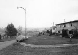
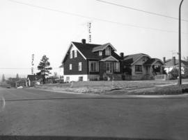
Puget Drive and Eddington Avenue - southeast corner - view southeast
Part of City of Vancouver fonds
Photograph shows 4662 Puget Drive
Eddington Drive, south side, from Paton Street to Haggarts Street
Part of City of Vancouver fonds
Photograph shows 2404 and 2406 Eddington Drive

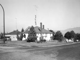
Haggart Street, east side, from 32nd Avenue to lane north - view south
Part of City of Vancouver fonds
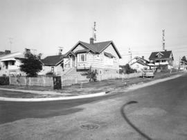
Slocan Street, west side 3rd to 4th Avenues - viwe northwest
Part of City of Vancouver fonds
Photograph shows 2699 and 2687 East 4th Avenue
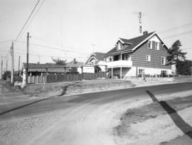
Slocan Street, west side, between 5th Avenue and lane south - view west
Part of City of Vancouver fonds
Photograph shows the rear of 2698 East 5th Avenue
Slocan Street, west side, 5th to 6th Avenues - view northwest
Part of City of Vancouver fonds
Photograph shows 2697 East 6th Avenue and the rear of 2698 East 5th Avenue
Slocan Street, west side, 5th to 6th Avenues - view southwest
Part of City of Vancouver fonds
Photograph shows 2698 and 2694 East 5th Avenue and a part of 2697 East 6th Avenue
![Abbott and Cordova [Streets looking] north](/uploads/r/null/8/a/8aab879fc7571cea390137d122ac3a89381071b678502757448c72f1fa930e4f/7cda2f7c-4836-4e9a-bb47-04f727a330f0-A42710_142.jpg)
Abbott and Cordova [Streets looking] north
Part of City of Vancouver fonds
![Abbott and Cordova [streets looking] east](/uploads/r/null/7/0/707fb0b0f3ba16b327f9d40a0a0a94b3f918509e20ac40ab413928d75ff1b6a8/c28af97b-ce7e-4953-b6ff-6e0979093ac1-A42711_142.jpg)
Abbott and Cordova [streets looking] east
Part of City of Vancouver fonds
Photograph shows Sissons Sporting Goods
![Abbott and Hastings [streets looking] north](/uploads/r/null/5/8/58a47efab97572b4c13cd6b981dd3dac02110898a57c7c528946196e79ba9346/863bf6d2-596f-499c-868a-28abd249fb85-A42714_142.jpg)
Abbott and Hastings [streets looking] north
Part of City of Vancouver fonds
Photograph shows Woodwards
![Alder [Street] and 6th [Avenue looking] west](/uploads/r/null/9/c/9c3510984925b6c73b0f03fe9efc1a5f0c4f319bc1012d03aa9caa3e5b60cb47/373b8340-f09c-4f8c-b47d-a21aa18ae822-A42723_142.jpg)
Alder [Street] and 6th [Avenue looking] west
Part of City of Vancouver fonds