
34th Avenue before paving, looking east
- AM54-S4-1-A-16-: A-16-55
- Item
- [191-]
Part of Major Matthews collection
34th Avenue before paving, looking east
Part of Major Matthews collection

Part of Major Matthews collection
Photograph shows 275 East 45th Avenue, 281 East 45th Avenue and 5893 St. George Street on the far right
![[72nd Seaforths] somewhere on Shaughnessy Heights](/uploads/r/null/d/5/5/d55eeefc0cbbc3027caf41168de857135ff4e60900c3f6b7d1645d10aeddf083/ef585107-ba80-4f76-9c17-5651d7b957e6-2011-037_142.jpg)
[72nd Seaforths] somewhere on Shaughnessy Heights

856 Felling large timber - North Arm Fraser River near Vancouver, B.C. - George Oliver's contract
Photograph shows a crew of nine loggers and a dog posing on a fallen tree.
Part of Major Matthews collection
Group portrait showing Laura Scratchley (Mrs. Samuel Garvin) and others

Part of Major Matthews collection
Group portrait showing the children and teacher John McMillan
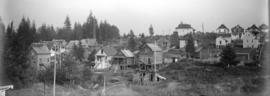
![A Few South Vancouver Homes [near St. George Street and 44th Avenue]](/uploads/r/null/b/7/b7b77e289b9d8a9036f11da16323787791cac94eaac7cad4ad933beb2c9618e6/51e367c3-05b5-4610-870b-090309ab3601-A25923_142.jpg)
A Few South Vancouver Homes [near St. George Street and 44th Avenue]
Part of Major Matthews collection
![[A group in front of the McCleery farmhouse]](/uploads/r/null/1/b/1b7671b0834408e07b06ffab7bf2fd3190277542e278134650f02e0d1eaef232/1e838876-3935-450d-987a-31b25f0db896-A70992_142.jpg)
[A group in front of the McCleery farmhouse]
Part of Major Matthews collection
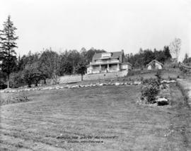
A Marine Drive Residence in South Vancouver
Part of Major Matthews collection
![[A McLaughlin Buick phaeton on Marine Drive near the mouth of the Fraser River]](/uploads/r/null/3/8/38dc81b8cc59e947afdca732c115d3106c45d14f11fa1ecffcf665975924be4d/c861bb7e-1340-4079-a7df-259decee14d0-A37247_142.jpg)
[A McLaughlin Buick phaeton on Marine Drive near the mouth of the Fraser River]
Part of Major Matthews collection
![[A part of Joyce Road (Street)]](/uploads/r/null/7/5/75473de28a4d07476fc7b54573c83f4ffa463e42bdd1649afdeb535feed7968a/9f5049ba-2311-4c7d-9589-f89a8e1a1896-A62740_142.jpg)
[A part of Joyce Road (Street)]
Part of Major Matthews collection
![[A partial view of Little Mountain Reservoir]](/uploads/r/null/0/d/0dee14fefd05cfde065138f977bb4749664696d4eedd1ee07d82f62b9cdb19d7/7b2a9eeb-2005-451d-a2ba-c9b49a836344-A24715_142.jpg)
[A partial view of Little Mountain Reservoir]
Part of Major Matthews collection
![[A partial view of Little Mountain Reservoir]](/uploads/r/null/5/e/5e1e9d2544aa31cb4c655aae55b69f862b778abc9b6bd7fe806e01c308078c6f/47061b14-da05-47a8-b658-e141e9c64b5f-A24714_142.jpg)
[A partial view of Little Mountain Reservoir]
Part of Major Matthews collection
![[A partial view of Little Mountain Reservoir]](/uploads/r/null/d/8/d8c554559fb63228f0a704ef9fe3fde8ef8a8f6be91c0193dbadeab18eef79b8/845a2717-bf19-4a86-a4d0-d1c310bd8d5a-A24716_142.jpg)
[A partial view of Little Mountain Reservoir]
Part of Major Matthews collection
![[A partial view of Little Mountain Reservoir]](/uploads/r/null/a/a/aa2468fb666bbf7817e28ee5c9fed8d16dd005115a46156046e4cf1ee93e5fd7/20d8a9c9-dd4c-45fc-939e-8696ed9413d0-A24713_142.jpg)
[A partial view of Little Mountain Reservoir]
Part of Major Matthews collection
![A South Vancouver Residence [near 45th Avenue and St. George Street]](/uploads/r/null/0/f/0f6ec5db8e0f089501c0e2318caf567d3690d698506fe1ea250ee32c3a29c4dc/b1bc105a-b3ce-4e3e-8eab-03e00c4ca8be-A25925_142.jpg)
A South Vancouver Residence [near 45th Avenue and St. George Street]
Part of Major Matthews collection

Aerial photo, vertical, Little Mountain and Oakridge and surrounding area
Item is a photograph of Little Mountain and Oakridge, showing from W 30th Avenue to W 54th Avenue, and from Hudson Street to Main Street. Includes the Langara golf course and Queen Elizabeth Park.
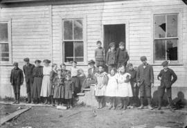
![[An East South Vancouver (Carlton) School picnic]](/uploads/r/null/4/5/4557ff30115e3bf5f7c448e539d65e6cbc5322f118bd2ffbe9239275ed7a50db/fc4720c6-81cb-4de0-8411-b91a25093a47-A36462_142.jpg)
[An East South Vancouver (Carlton) School picnic]
Part of Major Matthews collection
Group portrait showing Martin Ravey, Mrs. Alcock and others
![[An open trench for sewer construction on Lakeview Road (Hull Street)]](/uploads/r/null/e/8/e845d82171efbf6016fa7dba8864d5466ffaabe5a9e1f0a833db94d36e545042/ac06d5a1-680e-4b00-a950-07349e94556b-A37200_142.jpg)
[An open trench for sewer construction on Lakeview Road (Hull Street)]
Part of Major Matthews collection
![[An open trench for sewer construction on Lakeview Road (Hull Street)]](/uploads/r/null/6/d/6d72bb485a37de8b2936fffceb817a510172b07e64b641569e2a00c1cda3cab3/b36ae0ab-451e-44b9-ab07-b358e999bac3-A37201_142.jpg)
[An open trench for sewer construction on Lakeview Road (Hull Street)]
Part of Major Matthews collection
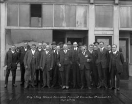
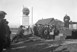
Army and Navy Veterans Association Provincial Convention South Vancouver, B.C.
Part of Stuart Thomson fonds
Group portrait
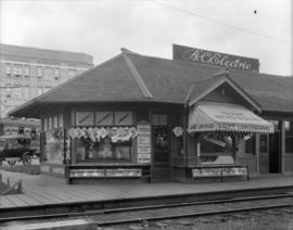
B.C. Electric Railway Company News Stands - New Westminster, Marpole, Granville Street Bridge
Part of Stuart Thomson fonds
Photograph shows a concession stand at the Marpole Station
![[B.C.E.R. (B.C. Electric Railway) street car lines on Main Street near 20th Avenue]](/uploads/r/null/4/2/b/42b219e7fb97545ad735386109b4ea7924443c2d4c5549bce971687df5cd65fa/afa7e2e3-192c-4e63-8f77-c07a843450af-2011-065_142.jpg)
[B.C.E.R. (B.C. Electric Railway) street car lines on Main Street near 20th Avenue]
Photograph shows S. Blackman Tobacconist and Bingham's dry goods in the background

Part of Major Matthews collection
Oblique view looking north across the north arm of the Fraser River towards Marpole

Part of Major Matthews collection
Oblique view showing sawmills on the north arm of the Fraser River
![[B.C.E.R. cars being loaded at Little Mountain Quarry]](/uploads/r/null/9/f/9fc291e96ee900cc77d3f0e55a8eca2d2b58903713c57825778915d1ba9e3786/e2d26fb3-99f0-4a52-ba48-9f5d17e11634-A25974_142.jpg)
[B.C.E.R. cars being loaded at Little Mountain Quarry]
Part of Major Matthews collection
Photograph shows Mr. Till, R. Piper, W. Prest and George Mare

Photograph shows the shops and businesses in the background
![[B.C.E.R. street car lines on Main Street near 19th Avenue]](/uploads/r/null/7/3/e/73e171a49b9d33fd82a7891a3093413ccdb0e0d606228e607ebabb058aa07b0f/07deaa2b-63e9-46a5-8321-0971b42db00c-2011-065_142.jpg)
[B.C.E.R. street car lines on Main Street near 19th Avenue]
Photograph shows Dewar's meat and produce market and S. BlackmanTobacconist
![[B.C.E.R. tracks along] Main St.](/uploads/r/null/e/9/e9af5af978c59e54a98cc79ebfbd2c26f387008ec508c0a6748261a3d8874419/ab6a6b77-3159-43f8-968b-267725efcc10-A19247_142.jpg)
[B.C.E.R. tracks along] Main St.
Part of Major Matthews collection
![[Bell(e)s from South Vancouver" float]](/uploads/r/null/8/5/8553f4b635773c643e1efa0d7477c4badd90faac7190c2f96b0ca5d5e2263e43/c5a79dc1-286a-4fed-abe6-f229beb93232-A26185_142.jpg)
[Bell(e)s from South Vancouver" float]
Part of Major Matthews collection
![Boundary Road and Park Avenue [Vanness Street] Station](/uploads/r/null/7/4/5/7454a742bd98a374f4d947f025601d8fb773a9d430b79f0ede14ce9844527c3b/c746218c-84b8-4d56-8a01-01c1c07d955c-CVA371-818_142.jpg)
Boundary Road and Park Avenue [Vanness Street] Station
Part of Major Matthews collection
![Boundary Road and Park Avenue [Vanness Street] Station](/uploads/r/null/1/5/158b957e2f59bf46258a58be7442e2890bfe702e8ed04418b64c917a83c29e26/ee14a5f7-6c67-40c8-931b-4dc21bcddcdd-A37339_142.jpg)
Boundary Road and Park Avenue [Vanness Street] Station
Part of Major Matthews collection
![[Brock School]](/uploads/r/null/3/5/35d8973d3b844e24f1b924051a806a4a3b36adc052d10f6cbea44df50309ae94/e0e9c6bc-e012-4119-aeb5-39d66accd4c1-A04443_142.jpg)
Part of Major Matthews collection
J.S. Matthews' notes with print or negative in Archives.
![Brock School. S[outh] Vancouver, B.C.](/uploads/r/null/2/b/2b8895b4f088b01a1eeac8e005cf3ce7a397515c4b9f5ee666687b58a984a2fe/a409a884-dbec-47ef-a46f-d513d9736d37-A04444_142.jpg)
Brock School. S[outh] Vancouver, B.C.
Part of Major Matthews collection
J.S. Matthews' notes with print or negative in Archives.
![Buffalo Grocery, 14th Avenue and Park [Commercial] Drive](/uploads/r/null/e/a/eafa4805b5cbde004a8ec53018e86ce8a3f7bc19cb9283c1dbb31e5183be2c21/54a36127-edac-4f96-af43-a99c7d462503-A43613_142.jpg)
Buffalo Grocery, 14th Avenue and Park [Commercial] Drive
![[Carleton School]](/uploads/r/null/6/b/6ba9a40a9e7a0498b0fae3cc2d0a7e8310875d5e723008d1b7109862cc54f2ba/fdd10c5b-f9f9-4077-ae26-9b526532a8ab-A07861_142.jpg)
Part of Major Matthews collection
![[Carleton School, showing old and new school buildings]](/uploads/r/null/1/5/153eafd04f55340499a80c8ab1e5e9f567e164eb0353cac39f56dd06b4d1560d/d489bfce-80c4-4fc0-8cff-efc2470ed666-A07860_142.jpg)
[Carleton School, showing old and new school buildings]
Part of Major Matthews collection
J.S. Matthews' notes with print or negative in Archives.
![[Carlton School at Kingsway and Joyce Road (Street) under construction]](/uploads/r/null/4/e/4e1a666c9727fd0ea2c402d2c0800c9e7768766e0ae9404876f0f5f6c6e435e7/b629f8f2-4a70-47ce-9c89-c8fe968cefdc-A62739_142.jpg)
[Carlton School at Kingsway and Joyce Road (Street) under construction]
Part of Major Matthews collection
![[Cattle at Shannon's Farm, Granville Street and 57th Avenue]](/uploads/r/null/9/e/9eb4971759ca19d52dee996d59331011c4b97e00f68db3096580c0dd49647207/054134b3-dd1a-44e0-8532-786fed889986-A09186_142.jpg)
[Cattle at Shannon's Farm, Granville Street and 57th Avenue]
Part of Major Matthews collection

Cecily R. Hunt with dog in South Vancouver
Cedar Cottage Brewery Southeast corner Westminster and Knight Streets
Part of Major Matthews collection
![Cedar Cottage east of Knight [Road (Street)] and 17th Avenue](/uploads/r/null/b/4/b492fa38996370dd180d169a3a884b5b32d052fb47457a9bb81d59d38817e546/acd0ece6-729f-487b-891e-21009740f639-A43619_142.jpg)
Cedar Cottage east of Knight [Road (Street)] and 17th Avenue

Cedar Cottage east of our house
Photograph shows the houses at 3401 and 3473 Fleming Street near the top right

Cedar Cottage north of our house
![Cedar Cottage southeast of Taylor [Road (Welwyn Street)] and Fleming Road [Street]](/uploads/r/null/f/b/fb92cbcaa99b75a770fc3c4d0af4b0188b96ca055381812b9574044cfe564105/65f53015-ca40-48ec-a329-6f5ea99890f9-A43621_142.jpg)
Cedar Cottage southeast of Taylor [Road (Welwyn Street)] and Fleming Road [Street]
Cedar Cottage, east of our house
![[Cement pipes sitting by a ditch running along the side of a house]](/uploads/r/null/f/c/fc34dbd78ff1476c965385d1469dc811298c9cbae026ca8dc6220119bdb0bc2b/913a69e1-956b-4235-a44c-617d2d8627a3-A19302_142.jpg)
[Cement pipes sitting by a ditch running along the side of a house]
Part of Major Matthews collection
Part of Stuart Thomson fonds
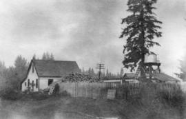
![[Chickens behind fence near log cabin and shed]](/uploads/r/null/c/6/c64ee4a02dfe50f8e8016cc06cafff5b091320401c031097358ae47d7031efb2/95b41d03-adb3-4a7d-9486-73eb0a92ab37-A07804_142.jpg)
[Chickens behind fence near log cabin and shed]
Part of Major Matthews collection
![[Child sitting on front steps of house]](/uploads/r/null/e/b/eba56afff4cb6420ae49dae04c40ba6d315868e7fd49ef0671cb063c8e0531b7/3e0941e6-bdd9-4657-bfd2-2f1ed2f97c36-A07790_142.jpg)
[Child sitting on front steps of house]
Part of Major Matthews collection