Showing 8 results

Archival description
Vancouver (B.C.) Zoning With digital objects English
Print preview View:

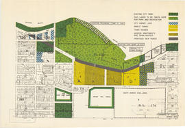
Redevelopment plan for Jericho Department of National Defence lands

Item is a map showing proposed redevelopment of portions of former Department of National Defence lands in the Jericho area. The map shows existing city parks, D.N.D. lands to be taken over for parks and recreation, city owned land, single family land, town houses, garden apartments and town houses and proposed new roads. The map appears to have been removed from a report.

Vancouver (B.C.). Engineering Services

Proposed zoning : comprehensive redevelopment areas

Item is a map showing proposed zoning for two comprehensive redevelopment areas according to the following district types: residential, commercial (suburban), commercial (medium density), industrial (light) and industrial (heavy). Map also shows the boundaries of the comprehensive redevelopment areas. These two areas lie roughly between Burrard Inlet in the north and 10th Avenue in the south and between Semlin Drive in the east and Burrard Street in the west.

Key map showing proposed areas for partial and comprehensive redevelopment

Item is a map showing the boundaries of the redevelopment study area, comprehensive redevelopment areas, limited redevelopment areas and the East End study area. The boundary of the study area lies roughly between Burrard Inlet in the north and 33rd Avenue in the south and between Nanaimo Street in the east and Carnarvon Street in the west.