- AM1257-S26-F2-8
- File
- 1859 (revised to 1886)
Showing 46 results
Archival description7 results with digital objects Show results with digital objects
C.P.R. lessee and exercising franchises of the Vancouver and Lulu Island Railway track profile
- AM1257-S26-F2-14
- File
- 1909
- AM1257-S26-F2-34
- File
- 1917

Excavation for 5'6" sewer on Copley Street just north of Lakeview
- AM1257-S25-: CVA 275-9
- Item
- Nov. 22, 1927
Section of 5'0" sewer on Copley Street just north of Lakeview
- AM1257-S25-: CVA 275-10
- Item
- Nov. 22, 1927
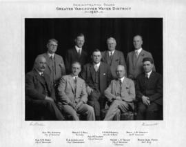
Greater Vancouver Water District Administration Board
- AM1257-S25-: CVA 275-1
- Item
- 1927
Shows Aldermen Patrick Gibbons, H.E. Almond and E.W. Dean of the City of Vancouver; Mayor L.D. Taylor (Chairman) of the City of Vancouver; Reeve C.C. Bell of Burnaby; E.A. Cleveland, Chief Commissioner; F.R. McD. Russell, Solicitor to the Board; Reeve J.W. Cornett of South Vancouver; and Reeve Alexander Paton of Point Grey.
Map of Vancouver, North Vancouver, and West Vancouver
- AM1257-S26-F2-11
- File
- 1936
Zoning diagram of the City of Vancouver
- AM1257-S26-F2-25
- File
- 1942
- AM1257-S26-F2-31
- File
- 1949
- AM1257-S26-F2-36
- File
- 1944-1949
- AM1257-S26-F2-33
- File
- [194-]
Vancouver and Districts Joint Sewerage and Drainage Board, plan showing float observations
- AM1257-S26-F2-37
- File
- [194-]
Fraserview project : south Vancouver re-plotting area plan showing street names
- AM1257-S26-F2-23
- File
- 1948 (revised to 1952)
- AM1257-S26-F2-9
- File
- 1954
Topographical map of the City of Vancouver
- AM1257-S26-F2-12
- File
- 1939 (revised to 1957)
Land ownerships (Vancouver, B.C.)
- AM1257-S26-F2-5
- File
- Sept. 1958
- AM1257-S26-F2-22
- File
- 1958
First Narrows, Vancouver harbour
- AM1257-S26-F2-35
- File
- 1958
Aerial survey (Vancouver, B.C.)
- AM1257-S26-F2-4
- File
- [195-]
- AM1257-S26-F2-13
- File
- [195-]
Steep slopes (Vancouver, B.C.)
- AM1257-S26-F2-28
- File
- [195-]
Zoning districts plan (Vancouver, B.C.)
- AM1257-S26-F2-30
- File
- 1956 (revised to 1959)
- AM1257-S26-F2-10
- File
- Apr. 1960
Proposed sewers in new subdivision (Vancouver, B.C.)
- AM1257-S26-F2-38
- File
- 1962
- AM1257-S26-F2-39
- File
- 1962
Vancouver - south (Delta, B.C., Richmond, B.C.)
- AM1257-S26-F11-1
- File
- 1963
- AM1257-S26-F2-2
- File
- 1964
Vancouver, British Columbia, distribution of dwelling units, 1961
- AM1257-S26-F2-17
- File
- 1964
Section 40 and 41 - Renfrew School
- AM1257-S26-F2-27
- File
- 1965
Section 40 and 41 - Renfrew School
- AM1257-S26-F2-26
- File
- 1965
Households and populations by enumeration areas 1966 census (Vancouver, B.C.)
- AM1257-S26-F2-19
- File
- 1966
Waterfront study atlas : shoreline inventory (Vancouver, B.C.)
- AM1257-S26-F2-21
- File
- 1957-1966
Household and population by enumeration areas 1966 census (Vancouver, B.C.)
- AM1257-S26-F2-20
- File
- 1966
Existing super-markets (Vancouver, B.C.)
- AM1257-S26-F2-24
- File
- 1967
- AM1257-S26-F2-6
- File
- Oct. 28, 1968
Burrard Inlet crossing approaches
- AM1257-S26-F2-7
- File
- Aug. 4, 1969
Development map series (Vancouver, B.C.)
- AM1257-S26-F2-3
- File
- 1957 (revised to 1969)
New Westminster Land District, Vancouver Land Recording District, Vancouver Land Assessment District
- AM1257-S26-F2-15
- File
- 1969
- AM1257-S26-F2-32
- File
- [196-]
- AM1257-S26-F2-29
- File
- 1969
- AM1257-S26-F2-1
- File
- 1966-1970
- AM1257-S26-F2-16
- File
- 1970
![[Sewage] Trench for 4'6" interceptor on 7th Avenue](/uploads/r/null/3/a/3a06f3b91f9f2903314d032b3849c52f12e163f45cc41586ee0e5718e34fc3b5/36252cee-90ab-4b0c-9752-1c01581b2368-CVA275-8_142.jpg)
[Sewage] Trench for 4'6" interceptor on 7th Avenue
- AM1257-S25-: CVA 275-8
- Item

W.H. Powell, first Chief Engineer of Water and Sewage Districts; died 1948
- AM1257-S25-: CVA 275-2
- Item
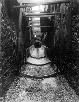
![Paving finish on invert for 5'6" interceptor in [sewage] tunnel at 1st avenue near Vine Street](/uploads/r/null/f/3/f3e44df5584efe0cbaaa2f1dc3c7fecc40289a78b7d00ab17da8ed1baad53bef/2862f8db-a8d7-4aa9-9b33-73956f89ba99-CVA275-7_142.jpg)
Paving finish on invert for 5'6" interceptor in [sewage] tunnel at 1st avenue near Vine Street
- AM1257-S25-: CVA 275-7
- Item

Bunkers at Dunbar and 1st Avenue
- AM1257-S25-: CVA 275-6
- Item
This is excavation for public works purposes.