
Angelo Calori, Hotelier of Hotel Europe
- AM1376-: CVA 81-1
- Item
- [ca. 1893]
Angelo Calori, Hotelier of Hotel Europe
![[The Daily Province delivery boys in front of the building at 138 West Hastings Street]](/uploads/r/null/d/d/dd421bf11eae583dfa78d2ea1e89a76fc7184b71534165a84b1eeafbe3283420/3a47d8fc-09d2-4b50-a934-af144fb12c64-A71516_142.jpg)
[The Daily Province delivery boys in front of the building at 138 West Hastings Street]
Photograph shows a sign for the British Columbia Printing and Engraving Corporation Lithographers and Printers office

Item is a photograph showing performers and some audience members on the lawn of the former home of F. Ronald Graham at 6101 NW Marine, now known as Graham House belonging to Green College, UBC.

Aerial photo, vertical, False Creek, Fairview to Kits Point
Item is a photograph of False Creek, showing English Bay to W 16th Avenue, and from Maple Street to the Cambie Street Bridge. Includes the Burrard Street Bridge, the new Granville Bridge, the Cambie Bridge, and Granville Island.

Aerial photo, vertical, University of British Columbia and University Endowment Lands

Aerial photo, vertical, Little Mountain and Oakridge and surrounding area
Item is a photograph of Little Mountain and Oakridge, showing from W 30th Avenue to W 54th Avenue, and from Hudson Street to Main Street. Includes the Langara golf course and Queen Elizabeth Park.

Aerial photo, oblique, downtown Vancouver to North Shore Mountains
Item is a photograph of the Vancouver area looking northwest over downtown Vancouver including the Hotel Vancouver, Provincial Courts, the Marine Building, Stanley Park, Burrard Inlet, Lion's Gate Bridge, and Coal Harbour.

Aerial view of Little Mountain area
Item is an aerial photograph showing an oblique view of the Little Mountain area.
![[Aerial view looking north over] Granville Island](/uploads/r/null/8/3/83f9be0a597100103c181fa4d68c68baa4a0802471126afafea3b7850103e12b/ea9e7fb6-7465-4fa6-8fa9-18923e3d9307-A49646_142.jpg)
[Aerial view looking north over] Granville Island
Oblique view showing the Granville Bridge and the new Granville Bridge under construction, the Kitsilano Trestle Bridge, of the Burrard Bridge and the industrial and undeveloped areas on the north and south sides of False Creek

Aerial photo, oblique, 41st Ave. and Oak St., Vancouver
Item is a photograph from Oak and 41st Ave, looking north, with a large partially cleared green area at the bottom of the frame, with downtown, Stanley Park, and the North Shore Mountains in the upper frame.
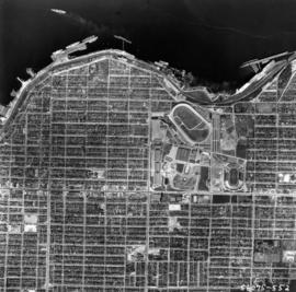
Aerial photo, vertical, Exhibition Park and surrounding area
Item is a photograph of Exhibition Park and the surrounding area, looking north. The area photographed runs from Vancouver Harbour to Charles Street, and from Lakewood Drive to Skeena Street.

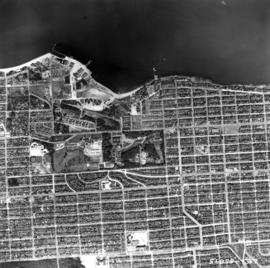
Aerial photo, vertical, Marpole and junction of Fraser River, Bridgeport
Item is a photograph of Marpole and northern Richmond, looking north. The area photographed centres on the fork of the Fraser River at Sea Island, and runs from W 67th Avenue to Cambie Rd., and from the western most tip of Richmond Island to the west tip of Mitchell Island. Includes the Marpole Bridge and both Oak Street and Moray bridges under construction.

Aerial photo, vertical, Deadman's Island, Coal Harbour and surrounding area
Item is a photograph of Deadman's Island, including Coal Harbour, and the southwest part of Stanley Park. Compass north is the left side of the photo.

Aerial photo, oblique, CPR docks in foreground, looking south Granville Street at centre
Item is a photograph of the Vancouver waterfront, looking southwest down Burrard Street, showing the waterfront and downtown Vancouver, including Waterfront Station, Hotel Vancouver, Marine Building, Burrard Bridge, Granville Street Bridge, and the city beyond.
Aerial photo, vertical, Jericho Beach Park and Kitsilano
Item is a photograph of Jericho Beach Park and the surrounding area, looking north. The area photographed runs from English Bay and Jericho Beach to W 16th Avenue,and from Sasamat Street to Balaclava Street.

Aerial photo, vertical, Iona Island and Fraser River
Item is a photograph of Iona Island. The area photographed includes the northwest corner of Sea Island and the southwest corner of Southlands. Rafts of lumber are visible.

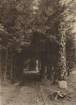
Stanley Park, four totem poles
Item is a photograph of four totem poles near Lumberman's Arch in Stanley park. The poles are (L-R): the Sisa-Kaulas Pole, the two Thunderbird House Posts pole and the Chief Wakas Pole (second from the right).

Vancouver's Medical Dental Building under construction
Item is a photograph showing Vancouver's Medical Dental Building during construction. Photograph shows the building's Rental Office and a group of people, including Mr. Robert Luscher (second right), one of the architects of McCarter-Nairne.
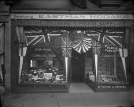
Camera and Arts Limited, 610 Granville Street

Aerial view of Brockton Point in Stanley Park looking south

H.R.H. Princess Elizabeth (H.M. Queen Elizabeth II) beside Royal car with girl Sea Scouts
Item is a photograph showing H.R.H. Princess Elizabeth (H.M. Queen Elizabeth II) beside Royal car with girl Sea Scouts in background. Taken during Royal visit of October 1951 to Vancouver.
![[View of road with horse-drawn buggy and motor vehicles at Stanley Park Pavilion]](/uploads/r/null/2/b/2bb86cfd48d67d4308d0ca0b3611ea21ffa19e50785318180a7af793bb49f9d2/1d1e6476-1ae4-4d5e-824a-c2e21375cf75-A37837_142.jpg)
[View of road with horse-drawn buggy and motor vehicles at Stanley Park Pavilion]
Photograph shows a roadway at the side of Stanley Park Pavilion with a horse-drawn buggy, motor vehicles and people walking.
![[Couple sitting on steps at Stanley Park Pavilion]](/uploads/r/null/1/8/1866fbb6a40f708d2f0e9aaa4cfcb0eeb94d2fcfb6692316510ec6441a09dc78/fa190d1b-f1db-4fc7-a8e8-68c6242647b1-A37841_142.jpg)
[Couple sitting on steps at Stanley Park Pavilion]
Photograph shows ground level view of a man and woman sitting on steps between potted plants at the Stanley Park Pavilion.

Local union I.A.T.S.E. members, organized Sept. 3, 1903.
Item is a photograph showing the members of the I.A.T.S.E. union. Names annotated on back of photograph. Standing, back row (L-R): Kato Forrest, Ad Harrington, Grant Robertson, Leo Smith, James Barr, Fred Blackadar, Charles Pratty, Arthur Cather, Fred Baker, W[illia]m Taylor. Seated, front row: Harry Spear, Harry Russell, J.C. Kloos, John Hood, Frank Woodsworth. The name Rod Martin is also written on back of photograph.

View of English Bay beach looking west
Photograph shows Joe Fortes seated on the far left and Roderick F. MacKenzie standing behind boat on the right.
![[Group of Sikh men in the rain on the waterfront]](/uploads/r/null/1/1/117e2b5fd1f9e916b980cdb08185d47cd69565c4dca347dea2b46407349d4187/e5d9d7e5-b53a-4e8b-aaee-440ff863f2cc-A71517_142.jpg)
[Group of Sikh men in the rain on the waterfront]
Item is a photograph showing a group preparing a cremation.
![Pender Harbour [Pender Island?]](/uploads/r/null/6/3/b/63b629a5813379cb3640aea0da51218da4a317a0931977a474787fde2fe731d4/7a952432-a23f-422d-80eb-3f21b6e3e32a-CVA440-29_142.jpg)
Pender Harbour [Pender Island?]

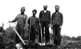
Labour crew clearing the Shaughnessy area
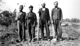
Labour crew clearing the Shaughnessy area
Item is a photograph showing labourers working to clear the Shaughnessy area. Annotation on veso is partially illegible and suggests that the photo was taken near Oak Street and [2-?]th Avenue.
![H. Cottrell [standing beside an overturned B.C.E.R. streetcar] at the foot of Main Street south](/uploads/r/null/a/3/a3c24ece56c3900d71b6ce2cf0fa2b425f7421fca55cc442f488c2efa7921152/ba7d45e3-356d-44a9-b69e-44457c86ae96-A37755_142.jpg)
H. Cottrell [standing beside an overturned B.C.E.R. streetcar] at the foot of Main Street south
The sign on the streetcar reads: Eburne Track Main St. South 25th Avenue

Canadian National Railway Station
Group of women and children in and around an automobile

West Hastings Street looking east from Granville Street

Item is a photograph of Pioneer steamer Beaver on rocks off Observation Point
Roadway and totem pole in Sitka
Item is a photograph showing a pole situated in the Sitka National Historical Park, Alaska.

Vancouver, B.C. University of British Columbia
![Vancouver, B.C. Connaught Br. [Cambie Bridge] and west](/uploads/r/null/8/1/2/812afcfdc1ae047980e6d5f922d44782e2cc8b2e14671603fe495311c69a4120/22405b60-cda0-4fc6-bd59-01a4219b4892-2014-055_142.jpg)
Vancouver, B.C. Connaught Br. [Cambie Bridge] and west

![Vancouver, B.C. Cambie Br. [bridge]](/uploads/r/null/d/a/9/da9942388ff02d1a8b65d1bfeb1c75a017e0cd4ae269e5557f50a4cb73df2adc/9b8ee4bb-f63f-4874-9e80-aeb2fd1058c2-2014-055_142.jpg)
Vancouver, B.C. Cambie Br. [bridge]

Ambleside & West Lion's Gate Bridge
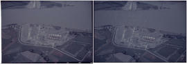
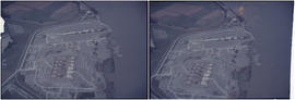
Vancouver Airport & Admin buildings


Woodward's New Development 1k.