![[Aerial view of Point Grey looking east]](/uploads/r/null/2/4/244ff7487a5ea3a7507037a8bf7eb90c0b6eb3d8617a1f12cdd00559bf869c24/77d29139-ccd1-40b1-a442-fd44f4bf4c62-A23409_142.jpg)
[Aerial view of Point Grey looking east]
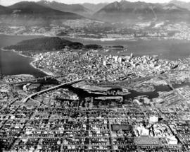
![[Aerial view of] Vancouver Harbour looking west](/uploads/r/null/3/9/39e190181d2db116f658c5c941cb4dbe105b3d13e149a21be0d06b03a5ea255d/c30dddc6-fe95-4d3b-aa46-79844574dc0b-A23410_142.jpg)
[Aerial view of] Vancouver Harbour looking west
![[Aerial view of Vancouver] looking north on Cambie St.](/uploads/r/null/8/7/873d1864c8c1ecfd6fefbe73579964efc0a5c07f9084e31ea6b0bb45ee92f0ed/39a1a351-ff7e-4705-a0f3-742e5d02193b-A23411_142.jpg)
[Aerial view of Vancouver] looking north on Cambie St.
![[Aerial view of] Sea Island airport [and] Vancouver](/uploads/r/null/3/9/39be0a04febde697763407500fa8cca39cd19f93a848dc226eaa572b4a1c1472/fc49cbd6-5b7c-4f12-8126-477fc03dff09-A23412_142.jpg)
[Aerial view of] Sea Island airport [and] Vancouver
![[Aerial view of West Coast] Shipyards [at] False Creek](/uploads/r/null/4/0/401d8167e8a67519a4715657c20efe63afdd1fdf3744d86be1fe6dc2ecf5ec02/bcdc80a9-d958-402c-a235-af0c9960b48a-A23413_142.jpg)
[Aerial view of West Coast] Shipyards [at] False Creek
![[Aerial view of] Vancouver General Hospital](/uploads/r/null/c/0/c0fb9b679686576e759fd2f69ef1973f19e0280a3ec2c54b975452d018a9dc8c/6e1ead7a-dcbc-4471-9110-6c4e29e5ee0d-A23414_142.jpg)
[Aerial view of] Vancouver General Hospital
![[Aerial view of] Kitsilano Beach and Park](/uploads/r/null/a/a/aaf846b92134a6c4802b0cc7a4d4c78d1c43de3c9093eb2406f56e46bebc2570/aab15264-7e1c-4aaa-971e-c4d581b93623-A23415_142.jpg)
[Aerial view of] Kitsilano Beach and Park
![[Aerial view of] Ballantyne Pier Vancouver looking W[est]](/uploads/r/null/a/b/ab21a951537af8577481426883c519ec2510d2b328587a08e87f0016f0d20845/1b5c8706-4783-48cb-9d99-f6a3c3ed9a54-A23416_142.jpg)
[Aerial view of] Ballantyne Pier Vancouver looking W[est]
![[Aerial view of] Ballantyne Pier, Vancouver looking N[orth]](/uploads/r/null/8/f/8f63b2561c1c19d33e413146cb6970de0d791f54635ce0e7c06bccd66151ab99/06b29381-6fb7-4bc3-a58f-0534b5d5ea2d-A23417_142.jpg)
[Aerial view of] Ballantyne Pier, Vancouver looking N[orth]

Aeroplane view of Ballantyne Pier - Vancouver, B.C.
![Aerial view of Ballantyne Pier [looking south]](/uploads/r/null/4/5/45235bb76932c348ff7b38c5a7aed42364cf041df0b52053089aaaeedf4e1546/a4719fdc-8ecb-403a-9dde-da5cfe6058e1-A23419_142.jpg)
Aerial view of Ballantyne Pier [looking south]
![[Aerial view of the Lower Mainland]](/uploads/r/null/9/7/9737587600450982cbbbd57c8f8a7ed7423c46d856af10146856eda380816f9d/0d07b828-6969-42f1-bff5-37322c26526b-A23421_142.jpg)
[Aerial view of the Lower Mainland]
![[Oblique view of] "Empress of Vancouver" over city of Vancouver.](/uploads/r/null/4/9/49632cf40df165f8fd8a69afe4c4f8be91bb5f3de968ba93378cb192c9c1c708/e87f1a36-8594-4185-95de-c8f73670552d-A23429_142.jpg)
[Oblique view of] "Empress of Vancouver" over city of Vancouver.
![[Aerial view of Vancouver looking northeast]](/uploads/r/null/e/b/eb04990a1e0714b74de255da43c9b8ae6f6f52e23bbf3735f707b20d0463fbe0/b9785bd2-0b41-4ed0-9f20-b5faf38aaf2f-A23478_142.jpg)
[Aerial view of Vancouver looking northeast]
![[Aerial view of Vancouver looking east]](/uploads/r/null/9/3/93309104da24ef0ea4391055c01c783c88d8d52c9939ee604b894d907555df68/564df6c6-3fbe-40b9-bba9-6386ae62ff3c-A23479_142.jpg)
[Aerial view of Vancouver looking east]
![[Aerial view of Kitsilano looking east over Kitsilano Beach]](/uploads/r/null/d/e/de9aa8187efba90164a4908026214320fff2d9978653d3f44f938fe4d88186b9/58cc6c82-2e2f-4948-9fa1-ba29c7edbea5-A23480_142.jpg)
[Aerial view of Kitsilano looking east over Kitsilano Beach]
![[Aerial survey view of First Narrows, Stanley Park, the West End, Downtown and North Vancouver]](/uploads/r/null/f/8/f875c0a639388b4936ef86faafb227a0fcad6478409cc8c2ff64fa2c06296ca5/94a6f99f-1ce3-4c9b-9e48-894735d096e9-A23486_142.jpg)
[Aerial survey view of First Narrows, Stanley Park, the West End, Downtown and North Vancouver]

Little Mountain from the air
![[Northeast aerial view of Burrard Inlet and Vancouver]](/uploads/r/null/6/6/662502a43d6839b8b0b3518a2f22ca5822fc6dc224c73d5002c705655d5ab329/48aa6304-734e-41ed-8ef2-daffdac1a38d-A23488_142.jpg)
[Northeast aerial view of Burrard Inlet and Vancouver]
![[Aerial view of] English Bay Beach [the West End and Coal Harbour]](/uploads/r/null/b/b/bb7c88b9152ef2f0cd0c703a1f4b8ec3bb0049756fc1b2866fca72704a96421a/73ce5f2f-8ac1-4465-aa81-d5454e7356bb-A23489_142.jpg)
[Aerial view of] English Bay Beach [the West End and Coal Harbour]
![[View of Georgia Street looking east from Broughton Street]](/uploads/r/null/b/3/b36a0ffb562445ab07907f340f899fb198d3da341503d87325ba6f798192024b/5888eb3d-0b22-4147-b01a-3a4f70ddb45c-A23490_142.jpg)
[View of Georgia Street looking east from Broughton Street]
![[Aerial view of Vancouver looking north]](/uploads/r/null/b/3/b3d3a0fbaf13d79ee1e9bda0902e11d0e4c0033f87fcfd48b7229bb32680e9e4/050796c7-0567-497d-b620-32f8958cbfb9-A23491_142.jpg)
[Aerial view of Vancouver looking north]
![[Aerial view of Downtown looking west from Granville Street]](/uploads/r/null/1/0/10903c6f6eb76e95eb8087a1b33bce6b998145848d5cee0ac237f1c676b77644/7cecb0f6-a946-4166-8861-9f447cb59be7-A23492_142.jpg)
[Aerial view of Downtown looking west from Granville Street]

Stanley Park from the air
Vancouver from the air looking north from over Little Mountain
![[Oblique view of downtown Vancouver in a north-west direction]](/uploads/r/null/5/c/5c03a395bbea3b7e6213c020856ebb51189ab9fa777b740bd771f4671d063162/541995be-d078-4a39-a750-27e3dd7e40f2-A23506_142.jpg)
[Oblique view of downtown Vancouver in a north-west direction]
![[Aerial view of] Pacific National Exhitibiton [at Hastings Park]](/uploads/r/null/a/1/a116a8e45ea6a44bdb7ba392de0b1b8efb36141a922d86476cb445f3e655d728/e966525e-2606-4380-8c22-e5a629d846e9-A23507_142.jpg)
[Aerial view of] Pacific National Exhitibiton [at Hastings Park]
![[Aerial view of the University of British Columbia campus]](/uploads/r/null/3/b/3b26ad7abfb1609951345f3da59b98d3acb9e35f6e934378ca7fe7b7f51bc1d6/60118a86-5a6f-4ba9-b3b3-f32583aabd22-A23508_142.jpg)
[Aerial view of the University of British Columbia campus]
![[Aerial view of] Stanley Park Vancouver BC [with] Second Beach Swimming Pool in the foreground.](/uploads/r/null/a/1/a15c959fdf22a475acde3dfbe34911d2ed0e908b82a181e788f415ac76b8aa42/60444948-c365-41d2-8860-876a49aa0885-A23509_142.jpg)
[Aerial view of] Stanley Park Vancouver BC [with] Second Beach Swimming Pool in the foreground.
![[Aerial view of] Vancouver B.C. looking east from English Bay](/uploads/r/null/0/3/03edb95dfe9ca891ff17aa9561a8ca736b17e0997af5e4e0c00c4fbce5babe44/9e1c7ace-8758-4763-a19f-d85080d23dbe-A23510_142.jpg)
[Aerial view of] Vancouver B.C. looking east from English Bay
![[Aerial view looking south-east from Georgia and Richards Streets]](/uploads/r/null/6/c/6c978477f3016794445b1dbe13e34d3d2af52193ddab85b2cc38d0c769dc1e95/5ea94235-2dfb-47a7-b6e6-5e0e0ab48362-A23511_142.jpg)
[Aerial view looking south-east from Georgia and Richards Streets]
![[Aerial view Downtown Vancouver and Coal Harbour]](/uploads/r/null/8/c/8c93e516088c33802463e3cade7f8669bd70f2cafc2ae8e069b9588009337ffd/9cb6889d-8bc1-456b-8780-3a3bc50d7baf-A23514_142.jpg)
[Aerial view Downtown Vancouver and Coal Harbour]
![[Aerial view of Vancouver]](/uploads/r/null/a/e/aea3d75fc7ebb88b78ad9efab62904bc9667abedf965cfd73ee6efd909a5e01b/ec4fb3c6-e62c-4383-b7f4-a31a2c2c00d1-A23515_142.jpg)
[Aerial view of Vancouver]
![[View of downtown Vancouver looking west]](/uploads/r/null/7/d/7dad7862dc87d31b1f2417a66c8ea3ec2a6043291daffccd93ffc8811f88af81/09c850ff-3ec3-440d-a2fd-cc45a34165d7-A23516_142.jpg)
[View of downtown Vancouver looking west]
![[Aerial view] Coal Harbour and Deadman's Island](/uploads/r/null/4/a/4a67a24f9b0323de5c85adc302a165b41d7406154f7c77d79e1322518c819b8b/406e5e08-4114-4cc0-b260-612267ba3842-A23517_142.jpg)
[Aerial view] Coal Harbour and Deadman's Island
![[Aerial view of the West End and Coal Harbour from English Bay]](/uploads/r/null/c/4/c40dd1bda7829c0fdb54bdd536310451672acfc5bad79ca7c321ea46afc69f54/b056f458-41bb-4cc2-b6ed-1614b43361ff-A23518_142.jpg)
[Aerial view of the West End and Coal Harbour from English Bay]
![[Aerial view of Vancouver]](/uploads/r/null/1/8/18f00497f9008905bcbff6f62bdc7c5625e266a0ac6b757f9d501d5684921d8a/b6974d97-c2a6-46b1-b55e-581ed03796c9-A23519_142.jpg)
[Aerial view of Vancouver]
![[Aerial view of Vancouver looking north]](/uploads/r/null/e/9/e99c2af4e3552b747125ecab20a652a7ab433e90c4960959c63de1b15d2c7cd4/73fb07b8-fe41-42a2-a131-8df2aa21c188-A23520_142.jpg)
[Aerial view of Vancouver looking north]
![[Aerial view of West End and downtown from English Bay]](/uploads/r/null/5/a/5a845863bb91abb50d97e1b5a0b5e8ec7446732759fbff7e36d884cf8adbb305/5b36d25a-4746-41f9-a62b-b7fb8955c01a-A23521_142.jpg)
[Aerial view of West End and downtown from English Bay]
![[Aerial view of West End from English Bay looking east]](/uploads/r/null/3/2/323cc28d66deaf7f42431a4acef03737b7f467d3891feda0bf9f872d1c045ed9/65bad4e7-adbe-48f9-85bf-7305b77abd1d-A23522_142.jpg)
[Aerial view of West End from English Bay looking east]
![[Aerial view of Kitsilano Beach]](/uploads/r/null/0/4/04933fd0b52b1825a12ac427f70fb35dc469232064c8156168d851093d1ae411/05361ecf-adfc-4cdc-be95-07157d2e9dd1-A23610_142.jpg)
[Aerial view of Kitsilano Beach]
![[Collapse of Second Narrows bridge during construction]](/uploads/r/null/7/b/7b1b0ec0cf16f91f2f421656c37e2edaa449477a299e7b2ac3df0109763f7707/a9342f72-46ec-44d5-bf84-fde7dc22a42a-A24446_142.jpg)
[Collapse of Second Narrows bridge during construction]

Vancouver City Hall
![[Oblique view of Vancouver, Fraser River and Richmond looking north]](/uploads/r/null/6/7/67878368e458f623ee7cf79447451ce2260f30bf1489f0d9f20e29345bb446be/7830eb88-81f4-4415-9203-3312f3d41b82-A31823_142.jpg)
[Oblique view of Vancouver, Fraser River and Richmond looking north]
![[Oblique view of Vancouver and Fraser River looking north]](/uploads/r/null/6/1/61a342ebf81034d372c51f19b89c6be6f127d44907e9564ad041e53d999aa613/5f487d00-501f-474c-a879-1aebe259242e-A31824_142.jpg)
[Oblique view of Vancouver and Fraser River looking north]
![[Oblique view of Vancouver, Fraser River and Richmond looking north]](/uploads/r/null/2/4/2473e5233782cac02b19f6d0f2d020af01dc9a183c7884d8ef807aaf5d710520/95201e92-101d-4115-b3a8-eeecbabcee40-A31825_142.jpg)
[Oblique view of Vancouver, Fraser River and Richmond looking north]
![[Northern View of Vancouver]](/uploads/r/null/2/7/2766800e51fbeb37e844be8f47dbb771c2a5103895149ec78c94d07ab4a60aa4/b260f3ff-6763-4265-9815-2bbd0055c832-A31921_142.jpg)
[Northern View of Vancouver]

Cape Mudge Lighthouse from the Air
![[Aerial view of Vancouver showing West and North Vancouver in the distance]](/uploads/r/null/8/d/8d777f00e47e79c44a6ac156af179a087158c26ea0c533480d2a2fb614a2f72e/3d4beb27-2bde-4b39-9fa9-51ad4fca5418-A37529_142.jpg)
[Aerial view of Vancouver showing West and North Vancouver in the distance]

Georgia Street Vancouver, B.C.