Cheakamus power survey for City of Vancouver, 1930-1931 : plan showing proposed development near Mile 19 - P.G.E. Rly. : sheet no. 6 to accompany report of E.A. Cleveland dated November 30th 1931
Cheakamus power survey for City of Vancouver, 1930-1931 : plan showing proposed diversion works near Mile 19 - P.G.E. Rly., detail sheet : sheet no. 7 to accompany report of E.A. Cleveland dated November 30th 1931
Cheakamus power survey for City of Vancouver, 1930-1931 : plan showing topography southward along a line from Cheakamus River near Mile 34, P.G.E. Rly. : sheet no. 9 to accompany report of E.A. Cleveland dated November 30th 1931
Cheakamus power survey for City of Vancouver, 1930-1931 : proposed storage reservoir at Daisy Lake : sheet no. 5 to accompany report of E.A. Cleveland dated November 30th 1931
Cheakamus power survey for City of Vancouver, 1930-1931 : topographical plan from Alpha Lake to Cheakamus River, above Mile 34, P.G.E. Rly. : sheet no. 8 to accompany report of E.A. Cleveland dated November 30th 1931
City of Vancouver
City of Vancouver
City of Vancouver [park sites June/80]
City of Vancouver, British Columbia
City of Vancouver, British Columbia
City of Vancouver, British Columbia : co-ordinate street index map 12
Freight lines : British Columbia Electric Railway Company Limited, Vancouver and Lulu Island Railway Company (Canadian Pacific Railway Company, Lessee)
Great Northern Railway. Map of the United States
Greater Vancouver and Fraser Valley
Map of Manitoba, Keewatin, British Columbia, and North West Territory
Map of Manitoba, Kewaydin, British Columbia and North West Territory shewing the country traversed by the Canadian Pacific Railway
Map of the city of Vancouver, British Columbia
Map of the Fraser Valley showing railway lines and district lots
Map of the municipalities of New Westminster City and District, British Columbia
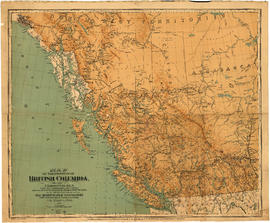
Map of the Province of British Columbia
Map of Vancouver, New Westminster, Steveston and the Lower Mainland District
Map of Western Canada
Map showing route Vancouver to Mission
Plan of the City of Vancouver. Western Terminus of the Canadian Pacific Railway
Plan of the City of Vancouver, B.C.
Plan of the Town of Port-Moody, British Columbia
Plan showing vicinity of Fisher Case, Nov 9th, 1949
Principal freight railway facilities of British Columbia Hydro and Power Authority
Proposed Raymur Ave. [Avenue] Trunk Sewer diverting sewage from False Creek reclaimed area
Proposed Raymur Ave. [Avenue] Trunk Sewer diverting sewage from False Creek reclaimed area
Proposed Raymur Ave. [Avenue] Trunk Sewer diverting sewage from False Creek reclaimed area
Railroad map of Greater Vancouver, British Columbia
Sheet 1 : Slocan Street to Boundary Road and Triumph Street to Burrard Inlet
Sheet 1: Slocan Street to Boundary Road and Triumph Street to Burrard Inlet
Sheet 10 : Clark Drive to Slocan Street and waterfront to Triumph Street
Sheet 10 : Clark Drive to Slocan Street and waterfront to Triumph Street
Sheet 11 : Carrall Street to Clark Drive and waterfront to Keefer Street
Sheet 11 : Carrall Street to Clark Drive and waterfront to Keefer Street
Sheet 11 : Wall Street to Rupert Street and McGill Street to Burrard Inlet
[Sheet 11 : Wall Street to Rupert Street and McGill Street to Burrard Inlet]
Sheet 12 : Nanaimo Street to Cassiar Street and Pender Street to McGill Street
[Sheet 12 : Nanaimo Street to Cassiar Street and Pender Street to McGill Street]
Sheet 12 : Ontario Street to Clark Drive and Keefer Street to Second Avenue
Sheet 12 : Ontario Street to Clark Drive and Keefer Street to Second Avenue
Sheet 13 : Ontario Street to Clark Drive and First Avenue to Sixteenth Avenue
Sheet 13 : Ontario Street to Clark Drive and First Avenue to Sixteenth Avenue
Sheet 13 : Rupert Street to Boundary Road and Eton Street to Burrard Inlet
[Sheet 13 : Rupert Street to Gilmore Avenue and Eton Street to Burrard Inlet]
Sheet 14 : Ash Street to St. George Street and Marine Drive to Fraser River


![City of Vancouver [park sites June/80]](/uploads/r/null/9/4/9484add7c4684ea3838e4d00ee8add3ecf85d78d5aa8fe2780cae273e59556a5/bd2464d8-2aa9-4501-aba6-8b3f7d130a42-MAP1032_142.jpg)


![Proposed Raymur Ave. [Avenue] Trunk Sewer diverting sewage from False Creek reclaimed area](/uploads/r/null/c/d/cddf61ac60b97b6fc54309ecbf8d1aea8e9aac3c672576fbd9953a05b82d42fc/14951fa4-0fd0-480c-a1f3-b7c2ef158398-MAP761_142.jpg)
![Proposed Raymur Ave. [Avenue] Trunk Sewer diverting sewage from False Creek reclaimed area](/uploads/r/null/5/2/5260099e92441f23442086ea3a8b5f7512bb5b4b4b5cbf554c9f13450bf4d37f/b5165f5d-bd82-46b5-9beb-0f969f7755ef-MAP761_142.jpg)
![Proposed Raymur Ave. [Avenue] Trunk Sewer diverting sewage from False Creek reclaimed area](/uploads/r/null/a/8/a8edd70876832fb32ffa8add8b5e261fe78b0e6efcb26d07a6fe1c74bf545b57/ac62eada-955d-4eee-8508-6bf4b71a21e5-MAP761_142.jpg)


![[Sheet 11 : Wall Street to Rupert Street and McGill Street to Burrard Inlet]](/uploads/r/null/e/b/eb84fb8de9ca2e1644a2e39bcbaad5253c563e8716cf25114e675fb7d40365ea/0935fb81-4662-411a-bdfd-c9823c7fb82b-MAP339_142.jpg)

![[Sheet 12 : Nanaimo Street to Cassiar Street and Pender Street to McGill Street]](/uploads/r/null/6/0/603c1cdc3adb1f0dec963bbd885c378ce1e23c71767cb0b461ef6ccc54807a5a/49483dc1-d90f-4a82-86cd-3c7a09f2ddae-MAP339_142.jpg)


![[Sheet 13 : Rupert Street to Gilmore Avenue and Eton Street to Burrard Inlet]](/uploads/r/null/f/0/f03aaa2671556fb722cf612a9736c0a6b919aff4af5a9dbe048dd93863af5773/30eb2a4c-b404-4552-81da-7461e4aacfaa-MAP339_142.jpg)
