[Photograph album:] Parliamentary and press party Quebec to Vancouver and return October 12th to 26th nineteen hundred and fifteen
[Photograph album:] Parliamentary and press party Quebec to Vancouver and return October 12th to 26th nineteen hundred and fifteen
[Vancouver Board of Trade Excursion to Okanagan and Kootenays August 21 to September 5, 1926]
[Vancouver Board of Trade Excursion to Okanagan and Kootenays August 21 to September 5, 1926]
![[View of a stream]](/uploads/r/null/1/7/174b6340e1b5afc241eeff8b60db572609019d8740fe546ebf3f5986ee949f65/8209c34b-adaa-481b-b1b3-8e610f2886af-A36256_142.jpg)
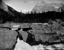
[View of a stream]

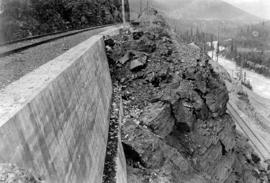
Clearing rock slide at Hell's Gate, Fraser River

Clearing rock slide at Hell's Gate, Fraser River

Clearing rock slide at Hell's Gate, Fraser River

Clearing rock slide at Hell's Gate, Fraser River

Clearing rock slide at Hell's Gate, Fraser River

Clearing rock slide at Hell's Gate, Fraser River
![[Aerial view of Poplar Island, New Westminster, during the Fraser River flood]](/uploads/r/null/3/6/36467dd9e46f14d73fcc41b882f34e88c1f1e1fc4dcdeac47a02edc9c0c0e548/eeb199bd-5e48-4161-8c01-5977acd83cee-A23474_142.jpg)
[Aerial view of Poplar Island, New Westminster, during the Fraser River flood]
![[Aerial view of Annacis Island and surrounding area during the Fraser River flood]](/uploads/r/null/8/6/86f336a392b2e63fe9ad7c407a94759fbba0440b22f898ac6f19d416451d16f4/07c70344-bc9e-42e2-81dc-f72a79dff600-A23475_142.jpg)
[Aerial view of Annacis Island and surrounding area during the Fraser River flood]
![[Aerial view of the Fraser River flood and surrounding areas]](/uploads/r/null/2/7/2749ceab3695f079945c8ceab77aa0cc238ba9056472d06ca9c52cd99d68e7a9/ff9c67ca-9723-40de-8d61-71df0fb7a708-A23476_142.jpg)
[Aerial view of the Fraser River flood and surrounding areas]
![[Aerial view of Fraser River flood and surrounding areas]](/uploads/r/null/b/a/ba7d2a125f6b034668f3b5db799085172d4b6176a0a15fd6640aa52f756097b8/101afdba-3c33-41d7-b770-62a007080dcb-A23477_142.jpg)
[Aerial view of Fraser River flood and surrounding areas]
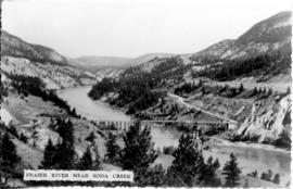
Fraser River Near Soda Creek
![[Agassiz-Rosedale Bridge]](/uploads/r/null/b/9/b9a0eb51c46b2d4d18d17731a36fa41612fd8d34f153433851eda3dd6d55e728/ab733b8f-00dc-42e4-bf26-7ef4383180bb-A24439_142.jpg)
[Agassiz-Rosedale Bridge]
![[Northern view of Oak Street bridge under construction]](/uploads/r/null/3/c/3ce95649becd6661bfb266e929ef9f7f0fb0047a4e0c644d3975486d3b9ddc9c/cf895488-0c64-458d-913c-9deac49a536c-A24440_142.jpg)
[Northern view of Oak Street bridge under construction]
![[View of the Oak Street, B.C. Electric and Middle Arm bridges]](/uploads/r/null/8/d/8d4f4dea792a3128229aecfd55a12d3a3432476462ad8cd9991e1ebb16cae075/62c52137-d9af-48bd-a8bc-2a12293b382d-A24441_142.jpg)
[View of the Oak Street, B.C. Electric and Middle Arm bridges]
![[View of the Marpole rail and highway bridges]](/uploads/r/null/3/9/39d081635b9fd32192951910755276ab7921e8ca55e3206da51189c0b65a8080/015c04a5-11d7-4d15-95ab-e794ef8e9f32-A24442_142.jpg)
[View of the Marpole rail and highway bridges]
![[View of Oak Street, Marpole rail and highway and Middle Arm bridges]](/uploads/r/null/4/1/4199f99a2a9078cbea68581cb0c930996461009cc1719feede4e449ea5a2379d/94cbe073-4e30-45d0-baea-1b0cb58d69b4-A24443_142.jpg)
[View of Oak Street, Marpole rail and highway and Middle Arm bridges]

Suspension Bridge near Spuzzum
![[A river in a canyon]](/uploads/r/null/d/a/da21fe715a207f26ba06803c0d424a34b17c8688f211c549a063643daa91eff8/093e1ea4-25d2-43f4-8178-e1f624ca1f93-A20192_142.jpg)
[A river in a canyon]
![[Capilano River]](/uploads/r/null/b/7/b7be2412e326a0c6f6201ef5cf910c7220fdd88f148b4db420c52812c2073ac7/aefd5b68-5e12-463d-b97c-3b4061d4c1bc-A20100_142.jpg)
[Capilano River]

Illecillewaet Valley from Look Out on Mount Abbott
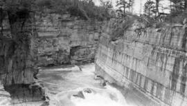
![Hill's [Hell's] Gate Canyon, Fraser River](/uploads/r/null/c/7/c7f92cbe21a70263cb4b6d5c0c157d12a94237293781fef80d8e2dd972fd1563/10a1c8ab-a1e9-4173-8670-a429a0afc682-A71369_142.jpg)
Hill's [Hell's] Gate Canyon, Fraser River

Looking Up the Fraser near Yale, B.C.

Beaver Canyon, Selkirks B.C.

Surprise Creek Bridge C.P.R. Selkirks Height 157 feet

Stoney Creek Bridge C.P.R. Selkirks Height 296 feet from below

Summer sun melts the 35 feet of snow and shows the last of our Western Ice Shield resting on a bed of cinders
![Dam of East Kootenay Power Co[mpany] on Elk River](/uploads/r/null/a/0/a0f4906f3b29d9805f29da003b09b26771bac37a489afbb1c390dfe3630f09eb/c94425c7-f179-42e8-853f-a4601ffc3360-A51021_142.jpg)
Dam of East Kootenay Power Co[mpany] on Elk River
![Elk River and Power house of East Kootenay Power Co[mpany]](/uploads/r/null/c/c/cc7d0fa99dc88c24c9cc772f60f4b9c89a7460174599372527fbae5f225bf00b/2afcde8f-2e93-4bc6-a36d-4ac8d6929107-A51022_142.jpg)
Elk River and Power house of East Kootenay Power Co[mpany]
Part of Canyon Elk River near Elko, part of old Dewdney Trail on left bank

Lower Canyon Elk River
In the upper Fraser Valley

In the canyon of the Fraser: entrance to Canadian Northern Tunnel at Yale B.C.
Board of Trade - Fraser River, Cariboo

Geographical : Fraser River, dry interior

Landscape - general : Fraser River

Kicking Horse River, near summit of Rockies

Columbia River, B.C.

Kicking Horse Pass, Rockies

Illecillewaet Canyon, near Revelstoke, B.C.

Illecillewaet Canyon, near Revelstoke, B.C.

Upper Falls, Kootenay River, B.C.

Fish Creek Canyon, Cambourne, B.C.

Lardeau River Canyon, near Ferguson, B.C.

Lardeau River Canyon, near Ferguson, B.C.

Illecillewaet Valley from Observation Point, Glacier, B.C.

Kicking Horse River and Mt. Stephen, Field, B.C.
Natural bridge, Kicking Horse River, Field, B.C.