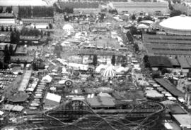
Aerial view of P.N.E. grounds and crowd at outdoor concert in Empire Stadium
Aerial view of P.N.E. grounds
Aerial view of P.N.E. grounds
VGLCC [Vancouver Gay and Lesbian Community Centre exterior] 1985
VGLCC [Vancouver Gay and Lesbian Community Centre exterior] 1985
Harbour Centre
West End
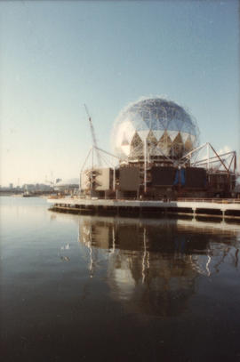
B.C. Place
Chinese Cultural Centre
Week of May 17-21 Habitat Forum [104 of 104]
Week of May 17-21 Habitat Forum [96 of 104]
Week of May 17-21 Habitat Forum [95 of 104]
Week of May 17-21 Habitat Forum [94 of 104]
Week of May 17-21 Habitat Forum [90 of 104]
Week of May 17-21 Habitat Forum [86 of 104]
Week of May 17-21 Habitat Forum [85 of 104]
Week of May 17-21 Habitat Forum [84 of 104]
Week of May 17-21 Habitat Forum [82 of 104]
Week of May 17-21 Habitat Forum [81 of 104]
Week of May 17-21 Habitat Forum [80 of 104]
Week of May 17-21 Habitat Forum [78 of 104]
Week of May 17-21 Habitat Forum [77 of 104]
Week of May 17-21 Habitat Forum [76 of 104]
Week of May 17-21 Habitat Forum [56 of 104]
Week of May 17-21 Habitat Forum [55 of 104]
Week of May 17-21 Habitat Forum [22 of 104]
Week of May 17-21 Habitat Forum [21 of 104]
Week of May 17-21 Habitat Forum [20 of 104]
Week of May 17-21 Habitat Forum [19 of 104]
Week of May 17-21 Habitat Forum [7 of 104]
Expo Centre
Sectional map of Vancouver showing streets, block and lot outlines, and building perimeters : Map 90 : Iona Island to Wood Island and Celtic Avenue to Sea Island
Sectional map of Vancouver showing streets, block and lot outlines, and building perimeters : Map 89 : Area west of Angus Drive to Barnard Street and S.W. Marine Drive to the North Arm of the Fraser River
Sectional map of Vancouver showing streets, block and lot outlines, and building perimeters : Map 88 : MacDonald Street to Laburnum Street/Angus Drive and 57th Avenue to the North Arm of the Fraser River
Sectional map of Vancouver showing streets, block and lot outlines, and building perimeters : Map 86 : Angus Drive to Laurel Street and 68th Avenue/67th Avenue to the North Arm of the Fraser River
Sectional map of Vancouver showing streets, block and lot outlines, and building perimeters : Map 85 : Laburnum Street to Fremlin Street and 57th Avenue to 68th Avenue/67th Avenue
Sectional map of Vancouver showing streets, block and lot outlines, and building perimeters : Map 87 : Barnard Street to Heather Street and 75th Avenue/Kent Avenue South to the North Arm of the Fraser River
Sectional map of Vancouver showing streets, block and lot outlines, and building perimeters : Map 84 : Laurel Street to Main Street and 67th Avenue/S.W. Marine Drive to the North Fork of the North Arm of the Fraser River
Sectional map of Vancouver showing streets, block and lot outlines, and building perimeters : Map 83 : Fremlin Street to Main Street and 57th Avenue to 67th Avenue/S.W. Marine Drive
Sectional map of Vancouver showing streets, block and lot outlines, and building perimeters : Map 82 : Main Street to Crompton Street and S.E. Marine Drive to the North Fork of the North Arm of the Fraser River
Sectional map of Vancouver showing streets, block and lot outlines, and building perimeters : Map 81 : Main Street to Inverness Street and 57th Avenue to S.E. Marine Drive
Sectional map of Vancouver showing streets, block and lot outlines, and building perimeters : Map 80 : Inverness Street to Gladstone Street/Nanaimo Street and 61st Avenue to the North Fork of the North Arm of the Fraser River
Sectional map of Vancouver showing streets, block and lot outlines, and building perimeters : Map 78 : Kerr Street to Boundary Road and S.E. Marine Drive to the North Arm of the Fraser River
Sectional map of Vancouver showing streets, block and lot outlines, and building perimeters : Map 79 : Gladstone Street/Nanaimo Street to Kerr Street and Bobolink Avenue to the North Arm of the Fraser River
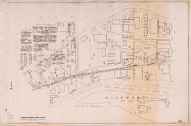
Sectional map of Vancouver showing streets, block and lot outlines, and building perimeters : Map 75 : Nanaimo Street to Kerr Street and 49th Avenue to Bobolink Avenue


![VGLCC [Vancouver Gay and Lesbian Community Centre exterior] 1985](/uploads/r/null/2/d/5/2d5fc70d248e410d8c630b7fbba07cd291ba7637eee93387499e31ab552edd2b/6ecb9f40-ef77-472f-88b3-61d0b6f20bf1-2018-020_142.jpg)
![VGLCC [Vancouver Gay and Lesbian Community Centre exterior] 1985](/uploads/r/null/9/3/3/93377fd73909bb36d531924ff5ca94bd276fe50c760322dd1d41cd81cc4693a6/fe5488f7-ac04-488d-95d1-d770bb3ed0bc-2018-020_142.jpg)


![Week of May 17-21 Habitat Forum [104 of 104]](/uploads/r/null/b/0/2/b02918a1771ae8be2536043d9aa73e4bd7293370ced453044a6b4039aa1b41a3/df5186da-90c3-4a86-97be-7d7a1e8567b0-CVA395-09142_142.jpg)
![Week of May 17-21 Habitat Forum [96 of 104]](/uploads/r/null/e/0/1/e01557295355072d2c6364b6970c25c0176c2a358913a66a8f2de95235736076/7b0b429f-fcc1-41a6-8754-89b4b48a8587-CVA395-09134_142.jpg)
![Week of May 17-21 Habitat Forum [95 of 104]](/uploads/r/null/e/3/a/e3a1c68b0a28bde751f76498e33294043200da57a50d3970de3237d1dff4c616/66dfd028-0259-4872-9dca-b9a3c88cd514-CVA395-09133_142.jpg)
![Week of May 17-21 Habitat Forum [94 of 104]](/uploads/r/null/c/8/6/c8692f7914528c5205b4a0dc52502bf1c06d7b639d06fe7ec31f92609e1bcfba/0f418605-8eb6-4c26-9b19-528e0f1326b4-CVA395-09132_142.jpg)
![Week of May 17-21 Habitat Forum [90 of 104]](/uploads/r/null/b/5/7/b5746788e1ec962e9cead5411cfdc9ea767c5bb65cdb7b9f1c8a87ea9ab5be9a/4cdf94fd-0596-4d1a-8f8b-e23bd87c27d5-CVA395-09128_142.jpg)
![Week of May 17-21 Habitat Forum [86 of 104]](/uploads/r/null/e/b/8/eb8a1c972ed434c25a66bbd2fa7de5726f4c13059126db4c1241c729e55d7f19/be9349fd-b169-496c-9c91-06243360b058-CVA395-09124_142.jpg)
![Week of May 17-21 Habitat Forum [85 of 104]](/uploads/r/null/b/0/6/b06935870605ac868894bc736b87a6edd8a9e08dc9c9c0d0dee9f8aa06170b40/4b705dfc-dce2-45d2-8ef0-896771d70fee-CVA395-09123_142.jpg)
![Week of May 17-21 Habitat Forum [84 of 104]](/uploads/r/null/8/6/7/8675ac57508b69b435f976b4f147179ffd3c3eaead32cc6c03490918f6f8aaf4/21a05550-32da-415e-9d08-225dfbb628e3-CVA395-09122_142.jpg)
![Week of May 17-21 Habitat Forum [82 of 104]](/uploads/r/null/c/8/a/c8aff0a24173e6d8125d6d29295ebca57f6527f7976764d12184328442251eec/d4700282-7e08-4a5a-8d1f-6e7e7d3c3e06-CVA395-09120_142.jpg)
![Week of May 17-21 Habitat Forum [81 of 104]](/uploads/r/null/a/b/2/ab2abd8fa95ca865ed9c6d352c161114b6b222786312a7e313b02f0fb7061597/c3560898-a006-4293-8868-79e05fc7a99a-CVA395-09119_142.jpg)
![Week of May 17-21 Habitat Forum [80 of 104]](/uploads/r/null/a/2/3/a2322033c78435595b0bfc9ddc19240800a7d37da57e19d6aa47c528377351ed/f8d712c6-c2be-42f0-9f6d-2c454a58b4c4-CVA395-09118_142.jpg)
![Week of May 17-21 Habitat Forum [78 of 104]](/uploads/r/null/d/f/2/df25c8aed98950383ab16894efb490e45c696d97b4bdf1606d5715b9aadce494/3f0ba317-740b-411f-887e-368c61d967b0-CVA395-09116_142.jpg)
![Week of May 17-21 Habitat Forum [77 of 104]](/uploads/r/null/e/8/b/e8bb4405a8834a7ca9b4bbf4cd754bd5ffe9cd76641bde3e8df3aa88dfcfbf0a/5405f837-c5f4-4bef-b56e-e68a0d957600-CVA395-09115_142.jpg)
![Week of May 17-21 Habitat Forum [76 of 104]](/uploads/r/null/a/7/0/a708acb05699eab47d8e47f2abf859d93312f702609fc27e57e4ceaad58dcc87/8471360f-3737-4ac5-a5bc-bbd0c600a8a9-CVA395-09114_142.jpg)
![Week of May 17-21 Habitat Forum [56 of 104]](/uploads/r/null/2/4/5/2453bf1101a98f8904d3005e1b441499f4da007f439e6f31a547ccd565bc6b42/eb6b9540-2bf4-488e-8144-65582cc2884a-CVA395-09094_142.jpg)
![Week of May 17-21 Habitat Forum [55 of 104]](/uploads/r/null/8/1/3/813799b2b6579aa434ab694420eaf16d65956da7a8457e07c6eeafc423191dc4/83109bc7-3aec-4d7a-85c3-83956ffcc69c-CVA395-09093_142.jpg)
![Week of May 17-21 Habitat Forum [22 of 104]](/uploads/r/null/4/1/2/412e4f6299ca56ae3deffacb30877d3e0d2c0d1ba9d34486daf68ff5e1267142/b6af604f-2a5c-4aa4-91e3-b97b88f0a1fa-CVA395-09060_142.jpg)
![Week of May 17-21 Habitat Forum [21 of 104]](/uploads/r/null/2/f/0/2f0ee92300e1148dbe7bfe743314aff01e61a5736c5c43d43ce9d0ec6574ea04/6cd137e9-cff6-4273-a52f-0909411c032f-CVA395-09059_142.jpg)
![Week of May 17-21 Habitat Forum [20 of 104]](/uploads/r/null/3/1/f/31f739ac988332eabaf40b1e6f8949a338867ee4020b8bd77f3b318439424ed3/54e21ab8-f8fa-4f68-8155-6b43d3cfcfa3-CVA395-09058_142.jpg)
![Week of May 17-21 Habitat Forum [19 of 104]](/uploads/r/null/6/3/9/6391e78beb4225a442e85c03ab7cf93ad44cb4cac1a2224707cd0e58f3382b22/f29c6654-3675-4065-be94-d23b6ec474b3-CVA395-09057_142.jpg)
![Week of May 17-21 Habitat Forum [7 of 104]](/uploads/r/null/b/7/8/b78cc267ebe88a723f3286778cdbaf659faf36cb5585e0238989f963aa9e852e/4f044048-ab40-4db7-aef9-f1ffb4412a38-CVA395-09045_142.jpg)