
Vancouver, British Columbia, south-easterly portion, formerly South Vancouver : major street plan

Vancouver, British Columbia : south-westerly portion, formerly Point Grey : major street plan

Vancouver, British Columbia : northerly portion, former City of Vancouver : major street plan

Vancouver, British Columbia

Vancouver, British Columbia
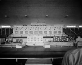
Vancouver Town Planning Commission display at P.N.E.

Vancouver British Columbia. Major street plan

Vancouver - the third largest city of the dominion, and Canada's chief Pacific port

The official street name map of the City of Vancouver
![Stanley Park [Golden Jubilee]](/uploads/r/null/2/4/24135e2d726e60ffbc74f0d81c3a53d51a38fe9ea1e86ecda92708249adac23b/1b46df5d-6871-41b2-b1dd-91a0c1d5ad02-MAP624_142.jpg)
Stanley Park [Golden Jubilee]

Rezoning application map (Point Grey Road)

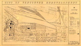
Redevelopment Project No. 2 Plan No. 1

Redevelopment project no. 2 area a-6, including existing blocks 72, 73, 87, 88, D.L. 196 : site plan and general location of utilities plan no. 3

Redevelopment plan for Jericho Department of National Defence lands

Proposed zoning : comprehensive redevelopment areas

Proposed system of drainage and sewerage for False Creek and marginal areas

Proposed industrial subdivision - Joyce and Vanness

Proposed development of Vancouver City Yard, 49th Avenue at Ross Street, South Vancouver

Properties from Victoria Drive to Nanaimo Street and Burrard Inlet to Triumph Street

Project 2, part of area "a" : utility diversions and rearrangements

Project 2, part of area "a" : plan of redevelopment

Project 2, part of area "a" : plan of redevelopment

Project 2, part of area "a" : pavements, curbs and sidewalks

Project 2, part of area "a" : pavements, curbs and sidewalks

Project 2, part of area "a" : identification plan

Project 2, part of area "a" : identification plan

Project 2, part of area "a" : existing utilities, water and sewer

Project 2, part of area "a" : existing utilities, water and sewer

Project 2, part of area "a" : existing utilities, gas, electricity and telephone

Project 2, part of area "a" : existing gas, electricity and telephone

Project 2, part of area "a" : condition of buildings

Project 2, part of area "a" : condition of buildings

Project 2, part of area "a" : aerial photograph

Project 2, part of area "a" : aerial photograph

Project 2, area "h" and part of "b" : proposed property acquisitions project 2

Project 2, area "h" and part of "b" : plan of redevelopment
Project 2, area "h" and part of "b" : plan of redevelopment

Project 2, area "h" and part of "b" : pavements, curbs and sidewalks

Project 2, area "h" and part of "b" : existing utilities, water and sewer

Project 2, area "h" and part of "b" : existing gas, electricity and telephone

Project 2, area "h" and part of "b" : condition of buildings

Project 2, area "h" and part of "b" : condition of buildings

Project 2, area a-2 : proposed property acquisitions project 2

Project 2, area a-2 : condition of buildings

Project 2: identification plan

Project 2 : generalized plan of redevelopment

Project 2 : generalized plan of redevelopment

Project 2 : generalized plan of redevelopment

Preliminary report on civic centre

Point Grey, B.C. : district map