
False Creek, Vancouver, B.C.

Stanley Park, Vancouver, B.C.

Tidal current chart, Vancouver Harbour : one hour before maximum flood at First Narrows

Tidal current chart, Vancouver Harbour : one hour after maximum flood at First Narrows

Tidal current chart, Vancouver Harbour : two hours after maximum flood at First Narrows

Tidal current chart, Vancouver Harbour : inside back cover

Lot numbers, boundaries, railway lines and street names in the municipality of Point Grey
![Americae sive novi orbis, no va descriptio : [the new world, commonly called America]](/uploads/r/null/7/f/9/7f9d7722fd935fbaf645638c66c9dc9500f9c329d254d3c44493af54d80e6483/b93f8b7c-cc81-45d5-b814-14796fa7011e-MAP667_142.jpg)
Americae sive novi orbis, no va descriptio : [the new world, commonly called America]
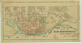
Plan of system of sewerage for the city of New Westminster, British Columbia

Champlain Heights : D.L. 334, group one, N.W.D.

Greater Vancouver road map : map cover

Map of Richmond municipality

Seaforth camp, Vancouver, B.C.

Redevelopment plan for Jericho Department of National Defence lands

Plan showing locations of oil and gas seepages and oil wells in Fraser Valley, British Columbia

Bus routes, city of Vancouver, November 26th 1937
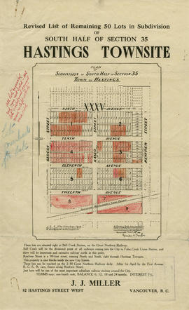
Revised list of remaining 50 lots in subdivision of south half of section 35, Hastings Townsite
Vancouver International Airport. Sea Island
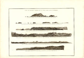
Vue de diverses parties de la côte nord-ouest d'Amérique
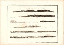
Vue de diverses parties de la côte nord-ouest d'Amérique

Insurance plan of Port Coquitlam : key plan and sheet 1

Insurance Plan of Port Coquitlam : sheet 4

Information concerning the City and District of New Westminster and the Province of British Columbia

Second section : Shaughnessy Heights
![McRoberts Island [Sea Island]](/uploads/r/null/6/9/6981a571c6d3102ee36ac270cce0eca9727531a3a9b4dd09f46f6f61adbbadbe/b8c696f2-5181-4f84-9e76-6420f9b2e916-Map800_142.jpg)
McRoberts Island [Sea Island]

City of Vancouver

City of Vancouver

Town-site of Hastings

Chinatown existing

Canadian Pacific Railway. Plan of part of branch line from Port Moody. A point on main line C.P.R. to English Bay, B.C.
![Vancouver, B.C. Plan showing location of water pipes, hydrants, etc. [Fairview slopes]](/uploads/r/null/6/9/69e0d6904facfa2a814069c15122fba46fc4d8077bff76402e95484a4b13d4d8/313b8940-1e98-45d4-b077-abe0f6bee66a-MAP72_142.jpg)
Vancouver, B.C. Plan showing location of water pipes, hydrants, etc. [Fairview slopes]

Vancouver, B.C. Plan showing location of water pipes, hydrants, etc. [Westminster Avenue to McLean Drive]
![Vancouver, B.C. Plan showing location of water pipes, hydrants, etc. [South Granville]](/uploads/r/null/e/a/eadb6d7351a77ac5788832abd83754cbe2966049728712aa7773bf6f2a74ff34/819e5ce5-621b-43ff-b1f5-f3bf4cac0562-MAP72_142.jpg)
Vancouver, B.C. Plan showing location of water pipes, hydrants, etc. [South Granville]
![[Map of Pioneer Place showing the area deeded to the City of Vancouver by the C.P.R.]](/uploads/r/null/4/1/41ba387b96586eb8554abcbf013c0e5cfbb116a42c8d1d1d2311fb1856694b2a/e3bd79d3-cd72-42e4-aa51-bc080514c205-MAP780_142.jpg)
[Map of Pioneer Place showing the area deeded to the City of Vancouver by the C.P.R.]

Map of portion New Westminster District

Vancouver, British Columbia

Vancouver sheet, British Columbia
![Plan of district lot boundaries, City of Vancouver, B.C. [index map]](/uploads/r/null/9/4/9469805f0ad98fa8c476e2fa1bd641a165448bbfe6840da2ca337894637001a4/9199ff56-1884-4c1f-8d1c-1a513de71a3d-MAP779_142.jpg)
Plan of district lot boundaries, City of Vancouver, B.C. [index map]

Sheet 4 : Slocan Street to Boundary Road and Seventh Avenue to Seventeenth Avenue

Sheet 5 : Slocan Street to Boundary Road and Seventeenth Avenue to Twenty-ninth Avenue

Sheet 7 : Clark Drive to Slocan Street and Seventh Avenue to Eighteenth Avenue

Sheet 13 : Ontario Street to Clark Drive and First Avenue to Sixteenth Avenue

Sheet 14 : Main Street to Knight Street and Fifteenth Avenue to King Edward Street

Sheet B : Imperial Street to Trutch Street and waterfront to Fourth Avenue

Sheet C : University Endowment Lands to Imperial Street and Fourth Avenue to Sixteenth Avenue

Sheet D : Imperial Street to Trutch Street and Fourth Avenue to Sixteenth Avenue

Sheet F : Wallace Street to Trafalgar Street and Sixteenth Avenue to Twenty-seventh Avenue

Sheet J : University Endowment Lands to Wallace Street and Twenty-ninth Avenue to Thirty-eighth Avenue

Sheet S : Musqueam Reserve to Macdonald Street and Forty-ninth Avenue to Fraser River

Sheet U : Churchill Street to Cambie Street and Forty-ninth Avenue to Park Drive