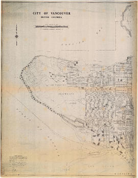
Map of City of Vancouver showing schools, parks, community centres, libraries, health units
Official Regional Plan : proposed amendments within the City of Vancouver
City of Vancouver : land use 1984
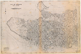
Existing service stations, retail shopping centres and commercial zoning : a basis for regulating location of service stations
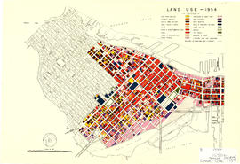
Land use - 1954
Zoning Map: City of Vancouver, British Columbia
Zoning Map: City of Vancouver, British Columbia
Zoning Map: City of Vancouver, British Columbia
Zoning Map: City of Vancouver, British Columbia
Zoning District Plan : City of Vancouver, British Columbia
Zoning map : City of Vancouver, British Columbia
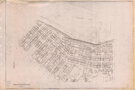
Zoning map : City of Vancouver, British Columbia [front side]
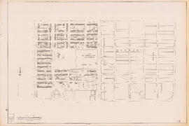
Zoning map : City of Vancouver, British Columbia [verso]
Zoning map : City of Vancouver, British Columbia [front side]
Zoning map : City of Vancouver, British Columbia [verso]
Zoning map : City of Vancouver, British Columbia
City of Vancouver, B.C. area map : Maple Street to Heatley Avenue and Burrard Inlet to 6th Avenue
City of Vancouver, B.C. area map : Heatley Avenue to Boundary Road and Burrard Inlet to 2nd Avenue/5th Avenue
City of Vancouver, B.C. area map : Inverness Street to Boundary Road and 2nd Avenue/5th Avenue to 32nd Avenue
City of Vancouver, B.C. area map : Inverness Street to Boundary Road and 32nd Avenue to 54th Avenue
City of Vancouver, B.C. area map : Inverness Street to Boundary Road 54th Avenue to the North Arm of the Fraser River
City of Vancouver, B.C. area map : Granville Street to Inverness Street and 6th Avenue to 37th Avenue
City of Vancouver, B.C. area map : Granville Street to Inverness Street and 37th Avenue to 57th Avenue
City of Vancouver, B.C. area map : Cartier Street to Inverness Street and 57th Avenue to the North Fork of the North Arm of the Fraser River
City of Vancouver, B.C. area map : Discovery Street to Granville Street and English Bay to King Edward Avenue
City of Vancouver, B.C. area map : Camosun Street to Granville Street and King Edward Avenue to 49th Avenue
City of Vancouver, B.C. area map : Wallace Street to Cartier Street and 49th Avenue to the North Arm of the Fraser River
City of Vancouver, B.C. area map : western boundary with University Endowment Lands to Camosun Street and English Bay to 16th Avenue; Musqueam Indian Reserve no. 2
North-East Burnaby Study, revised Simon Fraser townsite plan : 1967 City of Vancouver alternative proposals
Downtown peninsula - Vancouver, B.C. : contour lines at 10 foot intervals, datum line - 100
City of Vancouver, British Columbia : 1981 census of Canada
City of Vancouver : 1986 census of Canada
City of Vancouver, B.C. : curb ramp locations
City of Vancouver, British Columbia : Point Grey to Cypress Street
City of Vancouver, British Columbia : Cypress Street to Boundary Road
City of Vancouver, B.C.
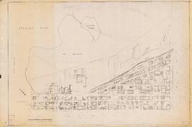
Sectional map of Vancouver showing streets, block and lot outlines, and building perimeters : Map 4 : Chilco Street to Burrard Street and Coal Harbour to Robson Street
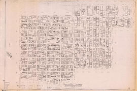
Sectional map of Vancouver showing streets, block and lot outlines, and building perimeters: Map 5 : Lagoon Street to Nicola Street and Robson Street to English Bay
Sectional map of Vancouver showing streets, block and lot outlines, and building perimeters : Map 6 : Nicola Street to Beatty Street and Georgia Street to Beach Avenue/Drake Street
Sectional map of Vancouver showing streets, block and lot outlines, and building perimeters : Map 7 : Burrard Street to Main Street and Burrard Inlet to Georgia Street
Sectional map of Vancouver showing streets, block and lot outlines, and building perimeters : Map 8 : Piers at Burrard Inlet between Main Street and Clark Drive
Sectional map of Vancouver showing streets, block and lot outlines, and building perimeters : Map 9 : Main Street to Clark Drive and Burrard Inlet to Prior Street
Sectional map of Vancouver showing streets, block and lot outlines, and building perimeters : Map 10 : Clark Drive to Nanaimo Street and Burrard Inlet to Frances Street/Ferndale Street
Sectional map of Vancouver showing streets, block and lot outlines, and building perimeters : Map 11 : Nanaimo Street to Rupert Street and Burrard Inlet to McGill Street
Sectional map of Vancouver showing streets, block and lot outlines, and building perimeters : Map 12 : Nanaimo Street to Cassiar Street and McGill Street/Wall Street to Pender Street
Sectional map of Vancouver showing streets, block and lot outlines, and building perimeters : Map 13 : Rupert Street to Boundary Road and Burrard Inlet to Eton Street
Sectional map of Vancouver showing streets, block and lot outlines, and building perimeters : Map 14 : Cassiar Street to Boundary Road and Eton Street to Pender Street
Sectional map of Vancouver showing streets, block and lot outlines, and building perimeters : Map 15 : Rupert Street to Boundary Road and Pender Street to Kitchener Street


![Zoning map : City of Vancouver, British Columbia [front side]](/uploads/r/null/d/f/df6282b6329852b263c3d33e20d903e4289eec05fde21bd58597f62d30789dde/225b2095-0e64-4986-878c-fd99eb6e1f18-PD2100_142.jpg)
![Zoning map : City of Vancouver, British Columbia [verso]](/uploads/r/null/8/e/8e44e80ba947d96b0a59a2bf4a48b60a1421fd04ba8480ddd13d7d13d0702e36/6b887f4f-8b76-48e2-866b-15499f569972-PD2100_142.jpg)
![Zoning map : City of Vancouver, British Columbia [front side]](/uploads/r/null/c/6/c61049cff53ecb5ec71dcc9b9de797d324126efb9c99b5eb62ea91c42d3b6842/743a013c-68a0-418f-8c6a-fd776aa116ef-PD2100_142.jpg)
![Zoning map : City of Vancouver, British Columbia [verso]](/uploads/r/null/0/c/0c28eac99426ce4ba64e4dfd48e45082c152014d6316047710a9601978663e70/d7052696-ccd5-4643-98d6-5e29205d9903-PD2100_142.jpg)