![[Northern view of Vancouver from Queen Elizabeth Park]](/uploads/r/null/7/4/74be239ca41d3c8e917bb89bcc04a218371dda9cbb806fabc2eac55afc5fee1e/934890e8-cf9f-47a4-a152-a07a17409a37-A43280_142.jpg)
[Northern view of Vancouver from Queen Elizabeth Park]
![[Western view of Fairview from the tower of King Edward High School on 12th Avenue and Oak Street]](/uploads/r/null/5/7/57f78634c36cdc44896b928e95b888dc11481e391bcf511d52692a2ee6953e09/d4c21e48-ce87-44ed-8181-22199bd4fa93-A43281_142.jpg)
[Western view of Fairview from the tower of King Edward High School on 12th Avenue and Oak Street]
![[View of Deadman's Island after being clear-cut of trees]](/uploads/r/null/0/d/0d52bc123aeaf44551a219dde291611efbf6a9f8b49e80e436cdbf33322e2eec/184b970b-6838-4854-bb67-7cd007564196-A43283_142.jpg)
[View of Deadman's Island after being clear-cut of trees]
![[Northern view from Downtown towards North Vancouver]](/uploads/r/null/c/4/c4e11a8eb3deeb229ed4c8539e7289a1e13542dc6ac3473728390d68502f859d/b78c1952-8208-46b9-9aab-747d52e91072-A43284_142.jpg)
[Northern view from Downtown towards North Vancouver]
![[Northern view of False Creek Flats from Mount Pleasant]](/uploads/r/null/4/c/4c21145a751d4755607fbd86dd1a02b6124e2a5073f3f6f876110310c5fabf21/0e75cede-a8b6-49ce-9be7-a64b95a7e3dd-A43285_142.jpg)
[Northern view of False Creek Flats from Mount Pleasant]
![[Aerial view looking northwest over Downtown]](/uploads/r/null/b/7/b7ca69254d2cbe14ffd3cb21ed6f3b1fed68dde7a4a5843876f8c173674d9d01/a1129a0c-5269-4488-9376-66246af93f6d-A43286_142.jpg)
[Aerial view looking northwest over Downtown]
![[Aerial view showing the northwestern section of Downtown]](/uploads/r/null/d/a/da84098b0ef036990e34132f726d1491bbbb1fc247cc76fc6659886372017fdc/a8601693-c900-4d47-a380-9979b203400b-A43287_142.jpg)
[Aerial view showing the northwestern section of Downtown]
![[View of the west side of the 600 Block Howe Street from the Hotel Vancouver]](/uploads/r/null/c/0/c02f6bb88e2050d63590f8a5785d169342306ab410ca9c27e710474bfc041360/b4848079-0ce9-44ce-b44f-cb935dea0e54-A43288_142.jpg)
[View of the west side of the 600 Block Howe Street from the Hotel Vancouver]
![[View of Fairview looking west from City Hall]](/uploads/r/null/d/8/d87892f743f488ae9a2f5003bc53c8a5f283417a8d4193ff9f894feec2d06564/ee474602-8f4a-4cf4-9f70-7a60fb4e7bad-A43291_142.jpg)
[View of Fairview looking west from City Hall]
![[View of Mount Pleasant looking northeast from City Hall]](/uploads/r/null/0/0/00f3be8cb9dc06c9f844f78cf67bf5b62a3d09109caccd699ac683b4f47a90e4/a8fc3c83-fbc0-4050-8f98-ae95939608f6-A43292_142.jpg)
[View of Mount Pleasant looking northeast from City Hall]
![[Northern view of the 600 Block between Howe Street and Granville Street from the Hotel Vancouver]](/uploads/r/null/f/f/ff1346527da8addf4e4ac2a5452cecc5e7730d9cf121286a4cc5d9efa6377496/f84fd027-2319-449c-8647-d7784d865359-A43293_142.jpg)
[Northern view of the 600 Block between Howe Street and Granville Street from the Hotel Vancouver]
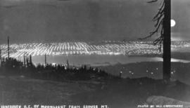
Vancouver, B.C. by Moonlight from Grouse Mountain
![[View looking east from Main Street and Pender Street]](/uploads/r/null/8/0/809cf6a26840094bf6d8fe3ddd67086496a879a0bb94d26685982dda7e6f42a7/0bafdc9e-9e34-4fc8-9e04-8b7bcfd96944-A43299_142.jpg)
[View looking east from Main Street and Pender Street]
![[Looking east from Carroll Street near the Georgia Viaduct]](/uploads/r/null/0/1/0198bb73987244240ed41a21da43f52e715080a9150510fb723dc0066626ebf0/179b2de9-bf97-4bb5-ab74-4463cb1bbf09-A43300_142.jpg)
[Looking east from Carroll Street near the Georgia Viaduct]
![[Looking south across Coal Harbour towards Downtown from Brockton Point]](/uploads/r/null/d/f/df878cfc52274ef0dfd5eda55cacc87ed1ea45a68b927ed3340c946d601307e6/f6d6db89-57b6-4095-9636-87eef03eb285-A43301_142.jpg)
[Looking south across Coal Harbour towards Downtown from Brockton Point]

Vancouver, B.C. from Deck of Incoming Steamer
![[View of Vancouver from Deadman's Island]](/uploads/r/null/a/0/a0850ee76e9744cd984cc88ad876a42f4e3b3b6130acd98c12f10174e1808a99/bb8f847f-b5b8-42f4-a859-d2fe95c65441-A43305_142.jpg)
[View of Vancouver from Deadman's Island]
![[View of a tallship in Burrard Inlet]](/uploads/r/null/9/2/92d00298fa2f6f6aaceff11fadb35afcecef231612bb1c633e506d729822cca9/9c26a667-3e50-450d-9658-b074c28e6052-A43313_142.jpg)
[View of a tallship in Burrard Inlet]
![[View looking east from the Marine Building showing C.P.R. Pier B-C and Pier D and beyond]](/uploads/r/null/5/7/577a64ba32fb0145b8926f3363be2e3620619f598e4f6192daf78e64335e2ba6/10814f31-cfa7-47af-939b-9e805050e7cd-A43317_142.jpg)
[View looking east from the Marine Building showing C.P.R. Pier B-C and Pier D and beyond]
![[View of Vancouver from Brockton Point]](/uploads/r/null/2/2/22eb67f9d04579b1ea4a63bbb8a286a15ce11e3920d1c77e7309d9a861cfc403/16262f7e-1eb7-46be-a335-8520fd865bf5-A43320_142.jpg)
[View of Vancouver from Brockton Point]
![[The waterfront at the foot of Seymour Street showing the C.P.R right-of-way under construction]](/uploads/r/null/6/6/66d35b65f6dda5beb624c8961aca146da05c566e7b8cf862d5f0cafd2661672a/35358bdd-7cb9-42a9-a263-de122665493c-A43322_142.jpg)
[The waterfront at the foot of Seymour Street showing the C.P.R right-of-way under construction]

Sunset
![[View from the Cambie Street wharf]](/uploads/r/null/8/0/80f45a722c44d1cb04762dc98f695e65d6aba6faf4ed8d973a76c0bdd028f9bc/84c96454-0626-4f5d-9626-4570f622ea49-A43324_142.jpg)
[View from the Cambie Street wharf]
![[View of the waterfront looking west from near the foot of Dunlevy Avenue]](/uploads/r/null/2/d/2da18c32d29d45a68d07d6089baba5d9044cba35ee38a6e26536450c1c650517/cb725dc3-0094-401b-81c6-db8f99de0218-A43325_142.jpg)
[View of the waterfront looking west from near the foot of Dunlevy Avenue]
![[View of Brockton Point from Coal Harbour]](/uploads/r/null/b/7/b72d0a91686983254a010ebe842ea27b32eadba8c953cb2acd8e3a52c2e70d97/e56e3de6-bcf1-4351-a837-fba28bb4e755-A43327_142.jpg)
[View of Brockton Point from Coal Harbour]
![[The cleared site of the C.P.R. Station between the foot of Richards Street and Seymour Street]](/uploads/r/null/1/8/180fe8d747865c7e3eb7b1d6f245a17ae7262583d69a6547b908ab2150a32fcc/4b21b2d9-4bdc-4c65-807c-867ba695ab78-A43328_142.jpg)
[The cleared site of the C.P.R. Station between the foot of Richards Street and Seymour Street]

Vancouver, B.C. from Deadman's Island

[Looking east from the Bank of British North America on the northwest corner of Hastings Street and Richards Street]
![[View looking west across Burrard Inlet from Prospect Point]](/uploads/r/null/9/4/9466f7028c9e35c004cb74395044c2b524f80f22f80421b1414f7df1dcb411ce/fe974e47-33ec-4d54-bd74-29b5a4080162-A43378_142.jpg)
[View looking west across Burrard Inlet from Prospect Point]
![[View of Vancouver from Brockton Point]](/uploads/r/null/f/a/faccb7ffd8899c4575efbc7fe8526b052ad52e140d1082bc00fa5a5d1597f7ea/be2271a1-9a6b-42f5-b151-9b6fa29ce75f-A43379_142.jpg)
[View of Vancouver from Brockton Point]
![[View of the Union Steamship Company wharf at the foot of Carrall Street from the water]](/uploads/r/null/6/3/633eb8b31ee31a70a32e581d579de8f4151199efede22586437fe118a2ded23f/b0cf1f33-1263-4d17-8c0f-d605e57f50e5-A43380_142.jpg)
[View of the Union Steamship Company wharf at the foot of Carrall Street from the water]
![[View of the Union Steamship Company wharf at the foot of Carrall Street from the water]](/uploads/r/null/1/6/16b49f44da552c162cf7a92ec25d71786db4794c57889560e3579f63d495815f/4fc25b4b-52d4-4ab8-9027-4ae997da5c78-A43382_142.jpg)
[View of the Union Steamship Company wharf at the foot of Carrall Street from the water]
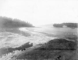
![[View of Bedwell Bay]](/uploads/r/null/1/3/1303666801e457064777d92bed0cac1a28b32124f2eb95fabc2f6aeae8db4fff/8f0e0f50-d0b5-4730-a327-4535e7932da1-A43385_142.jpg)
[View of Bedwell Bay]
![[View across Bedwell Bay towards Belvedere]](/uploads/r/null/9/9/9935ee617b9ed669654a537dd5d1913fde846fefbc9a4fd5d6e5cae1a674e01e/96c10272-ba9b-41a3-b618-d60c8aa1dbbb-A43387_142.jpg)
[View across Bedwell Bay towards Belvedere]

Vancouver's skyline by night as seen from Stanley Park across Burrard Inlet
Coal Harbour Vancouver, B.C.

Vancouver from Brockton Point

Vancouver Ten Years Ago
![[Looking northwest from approximately Dunsmuir Street and Richards Street]](/uploads/r/null/f/2/f2b620c755c698440f98f17b3b1b714259fd09792eb7d003bef6b4c61cf70606/6258aaba-f0fe-4711-94e7-287d521ed10d-A43410_142.jpg)
[Looking northwest from approximately Dunsmuir Street and Richards Street]
![[Looking north from approximately Dunsmuir Street and Richards Street]](/uploads/r/null/4/c/4c177df5cebf475922d31564074c35dbfa1ea58460fa0a62cc02e85fb996de16/2404b6ba-dcdd-43bd-98e5-ce4957f9f575-A43411_142.jpg)
[Looking north from approximately Dunsmuir Street and Richards Street]
![[Looking northeast from approximately Dunsmuir Street and Richards Street]](/uploads/r/null/f/3/f38f40085bfcf3381c8c0ccd91fef95c8b3ffd20b1165fa3477cfdf2e5caa6dd/1d1b1d2c-1c2d-4d0a-8b36-699043cc7ad6-A43412_142.jpg)
[Looking northeast from approximately Dunsmuir Street and Richards Street]
![[Looking east from approximately Dunsmuir Street and Richards Street]](/uploads/r/null/7/2/727b630d16577936fe0df360b0c849850d568f0d93f999c87edd7f8540943db2/9f95ae2b-2fe0-4eed-8c15-49d0dda8b504-A43413_142.jpg)
[Looking east from approximately Dunsmuir Street and Richards Street]

Looking West from Hastings Sawmill Dock
![[View across the Second Narrows from "Chaythoos" near Prospect Point]](/uploads/r/null/1/f/1f0b8fa5772e68b00eb65ab78a25f51fdf08aa2f2087ec230c89b398699ac363/2b2dd412-ab08-4573-bf2c-65b62f8841de-A43420_142.jpg)
[View across the Second Narrows from "Chaythoos" near Prospect Point]
![[Northern view from the tower of King Edward High School on 12th Avenue and Oak Street]](/uploads/r/null/c/6/c6a2098e8be2096dd153388c7cc69b6590ff14fcd374b1ac1f691ebf1dc50441/abe0536e-5915-41aa-9d09-95d6c9e97be5-A47183_142.jpg)
[Northern view from the tower of King Edward High School on 12th Avenue and Oak Street]

Vancouver from North Vancouver
![[View of a group hiking among boulders near Howe Sound]](/uploads/r/null/5/9/59e09ba78044d7cfaef01f710196fd099e494777ebf5b8278b17196d59c55a5f/3ee06a56-6546-4d7d-adb9-c58a587de5cd-A60887_142.jpg)
[View of a group hiking among boulders near Howe Sound]

Buccaneer Bay, B.C.
Buccaneer Bay, B.C.

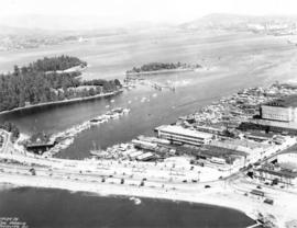
Waterfront Vancouver, B.C.