Showing 46 results
Archival description46 results with digital objects Show results with digital objects
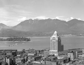
![Barge [and] Vancouver sky line](/uploads/r/null/8/f/8ff5d35b3ba17768ab38a2181b76e469ae277a943e748f46685af78cff5f884c/625c0fa9-676a-4da5-b3b7-d8b8b671cdfd-A05485_142.jpg)
Barge [and] Vancouver sky line

Brockton Point from the water

Burrard Inlet from Stanley Park

Burrard Street from the Marine Building

City of Vancouver
City of Vancouver

City of Vancouver from top of City Hall

City of Vancouver from top of City Hall

City of Vancouver from top of City Hall
![First cabin of Garibaldi Hostels [under construction]](/uploads/r/null/3/6/36fbfd7c3c8b1e784cdfb4cdf3ad89b7ad41c911ee8a399682e0fc9b8a8f2a1c/8af065dd-a87a-4fbb-b0da-86f1f5798814-A14810_142.jpg)
First cabin of Garibaldi Hostels [under construction]

Garibaldi Lake looking west
![Garibaldi Mountain [showing] Columnar Mountain in foreground](/uploads/r/null/7/a/7a807283493af89ef88093dcfdd0d493e90a1ab7fa284188f7469742e55ed884/bc950e1c-7515-4968-97f9-6ce80cbabbbb-A14811_142.jpg)
Garibaldi Mountain [showing] Columnar Mountain in foreground
![[Looking across the water from] Pacific Mills [dock on the] Queen Charlotte Islands](/uploads/r/null/2/8/287b948daf5968d243170070627b05292ccfc0f574696c223db2a8274093544c/23b71184-a2ee-44d3-b4a3-34c561b1cd98-A14906_142.jpg)
[Looking across the water from] Pacific Mills [dock on the] Queen Charlotte Islands
![[Looking west across the Bow River from North Hill]](/uploads/r/null/b/6/b6dbadac3b3a5f7c01e4338b90434397e40c9261b3cecfe75d42c843e7f56a5c/ac0a92de-e4a4-40d7-8a11-8283616b3d4c-A07245_142.jpg)
[Looking west across the Bow River from North Hill]

Mount Garibaldi

Port of Vancouver
![Scenic [view of the] Inside Passage](/uploads/r/null/4/5/451523251b96782e610d4c76f0ac95d9b2639be5085660e50fa6aa5b31d3876e/2e06d2ea-b955-46d0-ac9d-bfd98d501197-A07304_142.jpg)
Scenic [view of the] Inside Passage
![Scenic [view on] Vancouver Island](/uploads/r/null/e/3/e3c4157bbd7023413f30bc06e776b41cb804f7f09eeb4a030dca40025d57e7c7/5a6b44f0-2c1a-44a8-ad3c-cd6d59b4418d-A07418_142.jpg)
Scenic [view on] Vancouver Island
![The Black Tusk [in] Garibaldi Park](/uploads/r/null/0/f/0f42a3ad1d828a1498d595ff36b7e3a6bfb035bda959e09e2f93ced0dfc7aa46/edcc0e8c-236f-485a-b500-a31e5c9d72ef-A14807_142.jpg)
The Black Tusk [in] Garibaldi Park
![[The Burrard Bridge]](/uploads/r/null/0/5/05c95422d5df43694741f18972703078de60102bae42214ec23e03e7431a1720/6c4dce6f-5aca-4843-8e9d-c937c59d706a-A03429_142.jpg)
[The Burrard Bridge]
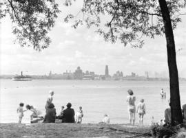
Toronto from Centre Island
![Town and mill from booming grounds [at] Pacific Mills](/uploads/r/null/9/f/9faf5089eab394c796b6a8c6068bb24041ec4596502f1542a1c23c928050a01a/497b21f2-cebf-4a31-a7fc-0648b0f7eb51-A14753_142.jpg)
Town and mill from booming grounds [at] Pacific Mills
![Turner Valley Oil [scenic view]](/uploads/r/null/f/e/fe09f263cc416550f71dc4af3fb5855810a6a2e52189855b73f3846f6f4538ab/6e812c09-daa8-44e5-b54a-91a483f78040-A07117_142.jpg)
Turner Valley Oil [scenic view]

Turner Valley scenic view
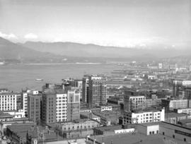
Vancouver from top of old Hotel Vancouver
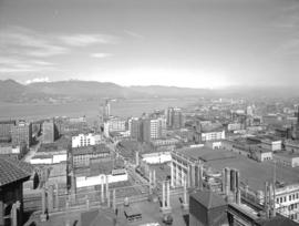
Vancouver from top of old Hotel Vancouver

Vancouver from top of old Hotel Vancouver

Vancouver from top of old Hotel Vancouver
![[View across the North Saskatchewan River]](/uploads/r/null/d/1/d1e0726a2ee0cc278c42e35106e5d2b6aafc8875bd97d9ee40c69edf0f4703e4/8423392c-41fa-4fa1-9d23-4f9c3b1b109b-A07240_142.jpg)
[View across the North Saskatchewan River]
![[View across the North Saskatchewan River]](/uploads/r/null/4/4/44bb46f1ed1a0f7b2c8c56ef9bc84c3872cca5a1518c0baa89f163a8f4dddd90/5a161060-321c-41e5-90db-9f4e522d1f79-A07241_142.jpg)
[View across the North Saskatchewan River]
![[View across the North Saskatchewan River looking west]](/uploads/r/null/3/2/3270d431b47171258bc69ea34ae78399c1968495c13fb14919d685ca616d7b0b/dca7edc8-44fa-4845-a568-65c1b3368234-A07244_142.jpg)
[View across the North Saskatchewan River looking west]
![[View across the water from] Sandspit [on the] Queen Charlotte Islands](/uploads/r/null/2/7/278b146d67391964b22a9a530a7518a8093c13eccb46f019936e4b70351f2f1a/d0720a1b-fe6e-4c73-9de6-8df0b6289b10-A14947_142.jpg)
[View across the water from] Sandspit [on the] Queen Charlotte Islands
![[View at the top] of Mt. Seymour]](/uploads/r/null/d/a/dae027646b8924703e2de2d84b7667d6ba492cd3dc47edc6c3fb3e133a4e9f75/d306ca4d-761b-4e99-b535-0c417d2216d3-A03302_142.jpg)
[View at the top] of Mt. Seymour]
![[View from a] Pacific Mills [logging site on the] Queen Charlotte Islands](/uploads/r/null/7/5/75ff02caa339fcdfd97719730256158de9acc744e1ce1760d16519fd3037e70c/0b929a8d-1f49-4cf4-94eb-c9b6a8bb0543-A14880_142.jpg)
[View from a] Pacific Mills [logging site on the] Queen Charlotte Islands
![[View looking east from North Hill]](/uploads/r/null/8/5/8511db470a751932697ac0bd128f45f9ce8f891b2fe38b51bf4a46639f05bcaf/c413d773-a3be-4e19-9775-7ed2b146c602-A07246_142.jpg)
[View looking east from North Hill]
![[View of] Banff from [the] Alpine Clubs](/uploads/r/null/6/1/6165869500910601873a36c011125b99808b831a0103205d28793d305a01b76f/08c0c399-8201-4219-9160-c6161dcf4e6a-A07135_142.jpg)
[View of] Banff from [the] Alpine Clubs
![[View of] Brentwood and Inlet from Malahat, Vancouver Island](/uploads/r/null/6/6/66be6787377e14cbb31921ab1a269f2e710c4d93765fc37952afe4e8ab781b12/f1251454-6783-4e75-88d4-3d7a5793c76b-A03307_142.jpg)
[View of] Brentwood and Inlet from Malahat, Vancouver Island
![[View of] bridge and Holy Cross Mt. near Hope, B.C.](/uploads/r/null/c/2/c285d8b9f5b8af7f7922097d09089993530fc2a717e7036ff70852a0aa7f3d6d/254672a2-4993-4d93-aadb-7ce07e20c70f-A06918_142.jpg)
[View of] bridge and Holy Cross Mt. near Hope, B.C.
![[View of False Creek looking east from the Burrard Bridge]](/uploads/r/null/8/4/84922323cf591c851fbd4ab5489c940a600fdeb6911c11e122f77b8c798c04a2/5a3406ee-9419-4ebd-bd85-d51cecb6e953-A03428_142.jpg)
[View of False Creek looking east from the Burrard Bridge]
![[View of] new houses on Rushmore Heights](/uploads/r/null/5/a/5a664a8112e768daa14d249c89466efed189e4bdef0daf6802c2088e0e95c3f5/e9f0f8e2-1b5a-4035-a848-c36fb9cb51fe-A03487_142.jpg)
[View of] new houses on Rushmore Heights
![[View of] townsite [at] Pacific Mills](/uploads/r/null/6/8/68ed185eccdf9ab912cdfe592c5a1bbccf534ed0c0b2fd2cb2f6403b359eae3a/1d04146c-c3d0-4a5e-a781-d6df275e657c-A14781_142.jpg)
[View of] townsite [at] Pacific Mills
![[View of] townsite [at] Pacific Mills](/uploads/r/null/c/1/c1a22944348414406d5d0d44f48c2ba6a714665c651a822617a78113f9df8a67/228a6b5f-227a-4fd3-b128-71f0b8287581-A14780_142.jpg)
[View of] townsite [at] Pacific Mills
![[View of] townsite [at] Pacific Mills](/uploads/r/null/2/2/222dfa3de5235348fbe93262504c9166ea84d15c5790f8b58ab838306955b9b3/242300f5-3c03-45d0-89c4-104e9aff97bd-A14782_142.jpg)
[View of] townsite [at] Pacific Mills

View of Upper Howe Sound (Squamish) from Empire Mills' upper camp on way to Garibaldi Hostels
![View of Vancouver Harbour from [the] Marine Building](/uploads/r/null/a/e/ae71b8edf582f04cd127108b112156f9d1e81af53f3de808e7359e541ab4333e/502882b8-ed7f-4493-9a93-b2a0bd5e6b15-A06614_142.jpg)
View of Vancouver Harbour from [the] Marine Building
![[View overlooking] Pacific Mills [logging site on the] Queen Charlotte Islands](/uploads/r/null/9/e/9e659a899df427d86cce937d8d377beb1a308cb91a92ef9d086a9b1664c06c27/d6cd8f45-83e8-47d7-a7f4-8a32e0771130-A14879_142.jpg)
[View overlooking] Pacific Mills [logging site on the] Queen Charlotte Islands