Hydro-electric investigation maps, survey drawings, and measurement data
Sheet 1 : Slocan Street to Boundary Road and Triumph Street to Burrard Inlet
Sheet 2 : Slocan Street to Boundary Road and Charles Street to Triumph Street
Sheet 3 : Slocan Street to Boundary Road and Seventh Avenue to Charles Street
Sheet 4 : Slocan Street to Boundary Road and Broadway to Seventeenth Avenue
Sheet 5 : Slocan Street to Boundary Road and Seventeenth Avenue to Twenty-ninth Avenue
Sheet 6 : Knight Street to Slocan Street and Eighteenth Avenue to Twenty-ninth Avenue
Sheet 7 : Clark Drive to Slocan Street and Seventh Avenue to Eighteenth Avenue
Sheet 8 : McLean Drive to Slocan Street and William Street to Seventh Avenue
Sheet 9 : Clark Drive to Slocan Street and Triumph Street to Charles Street
Sheet 10 : Clark Drive to Slocan Street and waterfront to Triumph Street
City of Vancouver, British Columbia [index map]
Plan of district lot boundaries, City of Vancouver, B.C.
Sheet 11 : Carrall Street to Clark Drive and waterfront to Keefer Street
Sheet 12 : Ontario Street to Clark Drive and Keefer Street to Second Avenue
Sheet 13 : Ontario Street to Clark Drive and First Avenue to Sixteenth Avenue
Sheet 14 : Main Street to Knight Street and Fifteenth Avenue to King Edward Street
Sheet 15 : Oak Street to Main Street and False Creek to Sixteenth Avenue
Sheet 16 : Maple Street to Oak Street and False Creek to Sixteenth Avenue
Sheet 22 : Stanley Park to Burrard Street and waterfront to Robson Street
Sheet 23 : Stanley Park to Granville Street and Robson Street to False Creek
Sheet L : Trafalgar Street to Granville Street and Nanton Avenue to Thirty-eighth Avenue
Sheet M : Granville Street to South Cambie Street and Twenty-seventh Avenue to Thirty-eighth Avenue
Sheet N : Musqueam Reserve to Wallace Street and Thirty-eighth Avenue to Forty-ninth Avenue
Sheet O : Holland Street to Elm Street and Thirty-eighth Avenue to Forty-ninth Avenue
Sheet P : Trafalgar Street to Granville Street and Thirty-ninth Avenue to Forty-ninth Street
Sheet Q : Churchill Street to Cambie Street and Thirty-eighth Street to Forty-ninth Avenue
Sheet T : Larch Street to Granville Street and Forty-ninth Avenue to Sixty-first Avenue
Sheet U : Churchill Street to Cambie Street and Forty-ninth Avenue to Park Drive
Sheet X : South West Marine Drive to Ash Street and Fifty-ninth Avenue to Seventy-first Avenue
Sheet V and Z : Milton Street to Heather Street and Seventy-second Avenue to Fraser River ; Angus Drive to Granville Street and South West Marine Drive to Fraser River
Sheet S.V. 1 : Cambie Street to Carolina Street and Sixteenth Avenue to Twenty-eighth Avenue
Sheet S.V. 2 : Cambie Street to St. George Street and Twenty-eighth Avenue to Thirty-eighth Avenue
Sheet S.V. 3 : Cambie Street to Prince Edward Street and Thirty-ninth Avenue to Fiftieth Avenue
Sheet S.V. 4 : Ash Street to St. George Street and Fifty-first Avenue to Sixty-third Avenue
Sheet S.V. 9 : St. George Street to Argyle Street and Fifty-eighth Avenue to Fraser River
Sheet S.V. 8 : Prince Edward Street to Argyle Street and Forty-seventh to Fifty-eighth Avenue
Sheet S.V. 7 : Prince Edward Street to Argyle Street and Thirty-fifth Avenue to Forty-seventh Avenue
Sheet S.V. 6 : Prince Edward Street to Bruce Street and King Edward to Thirty-fifth Avenue
Sheet S.V. 5 : Ash Street to St. George Street and Sixty-third Avenue to Fraser River
Plan of District Lot boundaries. City of Vancouver, B.C.
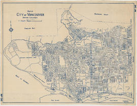
Map of City of Vancouver. British Columbia
Map of City of Vancouver. British Columbia
Plan of a 9.783 acre portion of Kitsilano Indian Reserve, District Lot 3610, Group one, New Westminster District


![City of Vancouver, British Columbia [index map]](/uploads/r/null/d/4/d4fc7ef393680c6515927aa960de863e6fd9e846c3fac12499691549673dc4b7/eed36b0b-2e63-48f2-a7ee-02ed3de937b9-MAP682_142.jpg)