
- AM1594-: MAP 817-: LEG1334.2
- Part
- 1964
Part of City of Vancouver Archives technical and cartographic drawing collection
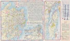
Part contains a street map of downtown Vancouver, a street map of Vancouver and the Fraser Valley, detail maps showing traffic interchanges corresponding to numbers on the Fraser Valley map, and general tourist information.


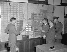
![[Relief map of Vancouver and vicinity from A.R.P. headquarters]](/uploads/r/null/e/b/eb9fabcd34f3b0fb46820e6cb57b08f5b96f8a280edb5d316e0da81fcc9cbd68/442da9a4-6ef8-4eb2-8a41-40bb550e77ee-A11108_142.jpg)

![Sectional map of Vancouver [zoning] : supplementary information for sheet S.V. 14](/uploads/r/null/9/9/e/99e95697f8bf81e7e1d7ae7f23f1e6c2f9e3a1f40a838b7d808b6f63e3005fcf/7dc593f3-a129-4947-9a06-77ad51b9e013-LEG1319_142.jpg)

![[Map of Stanley Park]](/uploads/r/null/d/d/3/dd322a6761f1b4f031344f1ff63d5db1c74e4762d10a3efb119a67a8e9bd90af/27af3243-6183-4b63-b514-1415597e6c47-CVA1095-00630_142.jpg)
![[Map of Stanley Park]](/uploads/r/null/9/2/f/92ff8e1d7d8890828829d6788574db4cda7b423aaa317ef08ec8594f81157c1e/ef3ec69f-74f3-440a-a83a-2097cfe0333b-CVA1095-00631_142.jpg)


![Plan of Vancouver, 1889 [fire map] : [Prior Street at Westminster Avenue]](/uploads/r/null/8/f/c/8fc66c2e89bd509d063179aa81af96aab4796167611fab0bd513e5312e3faf76/4699b3cc-c6f5-4b9e-9d53-ac1cfd547a84-LEG1319_142.jpg)
![Everest - PM 1 [and] 3-10](/uploads/r/null/1/2/1227428/3cbcda5b-4d84-44b0-a0f5-5ca2daaae18a-MI-336_142.jpg)

![Everest - CR [camera roll] 20-22](/uploads/r/null/1/2/1227457/469fb2a0-3151-45ca-8107-b0df2ecceb14-MI-335_142.jpg)
![The curse of the lost [gold] mine - tape 8 ; Interview [Don] Waite [in] lib[rary]](/uploads/r/null/1/2/1228702/e4aa034b-cc95-479d-bcbe-f5d6e8ed4580-MI-490_142.jpg)

![Hudson Bay Company Army [recruitmant campaign] window display](/uploads/r/null/2/e/2e4a1deaea587cf23de896ea458f508ecb3c965c3efee4f81c576f323b4677f7/dc9e1c4b-6631-4219-b3bf-a894292c174f-A03719_142.jpg)


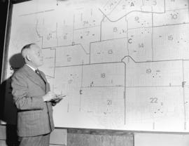


![Sectional map of Vancouver [zoning] : supplementary information for sheet S.V. 12](/uploads/r/null/a/4/4/a441dc2f617c6b8320dfff96301cc4f20bfdaa93829f2d7ea9c996b3ae81c4cd/d70f6e5b-f9fc-4ba2-9f46-362f23f19a0d-LEG1319_142.jpg)
![O'Brien Gourlay [promotion] "A Campaign is Born"](/uploads/r/null/9/8/98130411688b379e04be5033ae1c3ddbad844a4f46a55c81a59e6801bbaed929/f4b5c2b7-eb9d-4d97-93d1-dc90cd6599fd-A15170_142.jpg)


![Plan of Vancouver, 1889 [fire map] : [Jackson Avenue to Hastings Street to Dunlevy Avenue to Harr...](/uploads/r/null/9/c/b/9cb058b5430f742ff9092ead32136b0710bf8a256df4d7d8bfe9601ff02a7b7e/81fe310f-19a1-4237-8495-fbb492fa5bcb-LEG1319_142.jpg)