
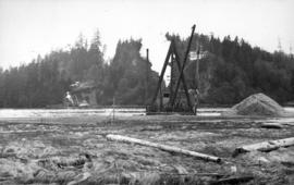
Clearing rock slide at Hell's Gate, Fraser River
- AM54-S4-1-A-10-: A-8-3.3
- Item
- [191-?]
Part of Major Matthews collection
30 results with digital objects Show results with digital objects
Clearing rock slide at Hell's Gate, Fraser River
Part of Major Matthews collection

Clearing rock slide at Hell's Gate, Fraser River
Part of Major Matthews collection

Clearing rock slide at Hell's Gate, Fraser River
Part of Major Matthews collection

Clearing rock slide at Hell's Gate, Fraser River
Part of Major Matthews collection

Clearing rock slide at Hell's Gate, Fraser River
Part of Major Matthews collection

Clearing rock slide at Hell's Gate, Fraser River
Part of Major Matthews collection
![[Construction of pier for Robin Hood Mills at the foot of Nanaimo Street]](/uploads/r/null/a/0/a094b11fbc6f85c51e84add4398d339074fad065ba212bff2c2f5bc6be22ac43/903af94d-e7ec-4d8c-9a78-d7d572263120-A08934_142.jpg)
[Construction of pier for Robin Hood Mills at the foot of Nanaimo Street]
Part of Major Matthews collection
Photograph shows partially constructed pier, and dredging machinery near shore.
Dredge getting depth on North Shore for basin for anchorage scows carrying building material
Part of Major Matthews collection
Photograph shows the Prospect Point signal station
![[Dredging at Coal Harbour]](/uploads/r/null/e/e/eeb620f31e2f761863fd7ac73dd43dca2e46389d677df8e9b3eb6cb746f437fb/cae78c96-b73c-4c55-b7e0-5a5c88dcf41e-SGN938_142.jpg)
Part of Major Matthews collection
Photograph shows dredging machinery, workers in a rowboat, and a diver at the side of the boat. J.S. Matthews' notes with print or negative in Archives.
![[Dredging at the Lion's Gate Bridge construction site]](/uploads/r/null/1/c/1c461d20c4f4832174307d3eb6bd990a686d9e3ba7da9877326d0bc942fe7c68/e0670b28-2ba3-42f2-b083-69897f0d9a1b-A24379_142.jpg)
[Dredging at the Lion's Gate Bridge construction site]
Part of Major Matthews collection
![[Dredging of first narrows of Burrard Inlet]](/uploads/r/null/0/6/067d7dfedaf5352387ac2fd676a32a47bcfd04148596086054a68b443c577f1a/c4986380-fb1f-45f4-bcf1-18d400c4dd03-A08776_142.jpg)
[Dredging of first narrows of Burrard Inlet]
Part of Major Matthews collection
Photograph shows ships and dredging machinery near shore. J.S. Matthews' notes with print or negative in Archives.

Part of Major Matthews collection
Construction progress photograph

Part of Major Matthews collection
Construction progress photograph

Part of Major Matthews collection
Construction progress photograph
![Filling of government dock at Victoria, B.C. [Victoria outer dock]](/uploads/r/null/a/c/ac3dfcbfd7931077bc2fd044d9ac56f115bc15a0a358e22caf0d0dd50edde8b7/dcf75c65-ad8b-4b52-b57c-bf2b8a6aefd3-A31777_142.jpg)
Filling of government dock at Victoria, B.C. [Victoria outer dock]
Part of Major Matthews collection
![Filling of government dock at Victoria, B.C. [Victoria outer dock]](/uploads/r/null/a/4/a407ab35e25717806ed19dee13e037e030e5e4a94cee438b0b27b6b923de43ce/82cdb86b-0638-46f6-8815-f9a538f91041-A31776_142.jpg)
Filling of government dock at Victoria, B.C. [Victoria outer dock]
Part of Major Matthews collection
![[Northward view of J. Hanbury and Co. Sawmill showing Granville Island under construction]](/uploads/r/null/8/3/83ec7ab11b42b6bf1a8155c4aed40ccaf92b3a8ae6208e0e307e926d273df42a/11514f5d-7e4e-4a98-a68a-7876f4c8abfd-A64091_142.jpg)
[Northward view of J. Hanbury and Co. Sawmill showing Granville Island under construction]
Part of Major Matthews collection
Photograph also shows the Granville Bridge, other False Creek mills and industrial buildings and Fairview Slopes to the far right.
![Ocean Falls [harbour dredging]](/uploads/r/null/1/e/1e7e09e17dcb3d0b28a30119bceaa2f16244f3ff09e4db0d582bf8f4d720d60c/64cfdccc-461e-4627-b615-908f9ba91921-A31758_142.jpg)
Ocean Falls [harbour dredging]
Part of Major Matthews collection

Pacific Dredging Co. Ltd. Vancouver B.C.
Part of Major Matthews collection
Photograph shows the Creosoting Works in North Vancouver.

Pacific Dredging Co. Ltd. Vancouver, B.C. April 15, 1915
Part of Major Matthews collection
Photograph shows a view of a dredging and reclamation project on the North Shore east of the First Narrows.

Pacific Dredging Co. Ltd. Vancouver, B.C. April 15, 1915
Part of Major Matthews collection
Photograph shows a view of a dredging and reclamation area on the North Shore east of the First Narrows.
![[Point Grey Partnership Pipe project - False Creek Section]](/uploads/r/null/d/a/da624f62e1094a9a0df7600f4643e5c3c55bcace6039309e4bd1f997e86055d9/be784e9b-bee2-4876-86f9-01c17f86cc52-A60139_142.jpg)
[Point Grey Partnership Pipe project - False Creek Section]
Part of Major Matthews collection
Construction progress photograph looking south showing a clam-shell dredging a pipe channel and the trestles for the Connaught (Cambie) Bridge
![[Point Grey Partnership Pipe project - False Creek Section]](/uploads/r/null/5/4/545aad9a4ab986bca12f556291bd8ff141e9989d776f006f87fdc863dcb34676/74170030-30fb-4820-8ad5-761915557afa-A60125_142.jpg)
[Point Grey Partnership Pipe project - False Creek Section]
Part of Major Matthews collection
Construction progress photograph looking south from Pacific Box Company's bulkhead (foot of Smithe Street) showing a clam-shell dredging a pipe channel and the trestles for the Connaught (Cambie) Bridge
![[Point Grey Partnership Pipe project - False Creek Section]](/uploads/r/null/b/3/b3121c261943606b4b1ff9b7112f5ff19ecccd795b50b288a1fbe2bc26b99937/953f4734-e854-4bf4-8db8-04d55a7a3950-A60124_142.jpg)
[Point Grey Partnership Pipe project - False Creek Section]
Part of Major Matthews collection
Construction progress photograph looking south from Pacific Box Company's bulkhead (foot of Smithe Street) showing a clam-shell dredging a pipe channel and the trestles for the Connaught (Cambie) Bridge

Part of Major Matthews collection
Panoramic view showing the Granville Bridge with the span open, C.P.R. Trestle Bridge, Robertson and Hacket Sawmill, Canadian Pipe Co., Vancouver Granite Co. and Marpole Coal Co.
![[View of Coal Harbour showing dredging, Pier A, the Immigration building and the site of Pier B-C]](/uploads/r/null/3/4/3419fe8cdc4199baa26713b3f651eca30a7896e99487e4f122f270f36246add1/ce6a57c4-0438-4ca1-b678-bceb9c69f838-A63907_142.jpg)
[View of Coal Harbour showing dredging, Pier A, the Immigration building and the site of Pier B-C]
Part of Major Matthews collection
Photograph also shows C.P.R. fuel oil tanks and cars and Pier D at the far right.
![[View of Coal Harbour showing Pier D, dredging, and C.P. railway yard]](/uploads/r/null/a/f/af0c10ae5aeb61ca4a197b4e372f1862f6fa32fb58347e2b94148897eec5e3c3/a7b91197-362d-42d1-b2a2-df14d10f4656-A63942_142.jpg)
[View of Coal Harbour showing Pier D, dredging, and C.P. railway yard]
Part of Major Matthews collection
Photograph shows Pier A to the left and a north shore ferry to the right.
![[View of False Creek showing the Granville Island reclamation]](/uploads/r/null/4/5/45b94fe3950893e0165f625b8372fe0bdc7d5fb2842ae0028bb0d079ac4f0530/d4561665-20ad-4549-816c-1f4e4332e729-A63481_142.jpg)
[View of False Creek showing the Granville Island reclamation]
Part of Major Matthews collection
Photograph also shows the Granville and the C.P.R. Kitsilano Trestle bridges, and the Kitsilano Indian Reserve.
![[View of Granville Island (reclamation partially complete) from the top of the Granville Bridge]](/uploads/r/null/9/6/96d6d8f1fa3c3c265993d58d7694dab19e96c14154062bbd2941d790457db371/98059cab-f1f8-4b41-8be1-84fe353976d4-A63479_142.jpg)
[View of Granville Island (reclamation partially complete) from the top of the Granville Bridge]
Part of Major Matthews collection
Photograph shows the creation of Granville Island by dredging fill from False Creek. Houses and buildings in Fairview Slopes are also shown.

Part of Major Matthews collection
Panoramic view showing two barges with Canada Public Works rock cutter and breaker structures. One ship is identified as the "Achilles" and the dredge ship as the "Mastadon".