
- AM54-S4-: Air P88
- Item
- [ca. 1952]
Part of Major Matthews collection
Oblique view. Photograph shows Queen Elizabeth Park, Little Mountain Reservior, the quarry and Little Mountain Housing Project.
Part of Major Matthews collection
Oblique view. Photograph shows Queen Elizabeth Park, Little Mountain Reservior, the quarry and Little Mountain Housing Project.
![[Excavation for the Little Mountain reservoir]](/uploads/r/null/3/d/3da175e1d173b1bd829a658fa139dc255159695172b83789c2e1beb721689ad3/75b2896f-7ea3-41fe-8df5-b722e4c5b209-A24712_142.jpg)
[Excavation for the Little Mountain reservoir]
Part of Major Matthews collection
![[A partial view of Little Mountain Reservoir]](/uploads/r/null/a/a/aa2468fb666bbf7817e28ee5c9fed8d16dd005115a46156046e4cf1ee93e5fd7/20d8a9c9-dd4c-45fc-939e-8696ed9413d0-A24713_142.jpg)
[A partial view of Little Mountain Reservoir]
Part of Major Matthews collection
![[A partial view of Little Mountain Reservoir]](/uploads/r/null/5/e/5e1e9d2544aa31cb4c655aae55b69f862b778abc9b6bd7fe806e01c308078c6f/47061b14-da05-47a8-b658-e141e9c64b5f-A24714_142.jpg)
[A partial view of Little Mountain Reservoir]
Part of Major Matthews collection
![[A partial view of Little Mountain Reservoir]](/uploads/r/null/0/d/0dee14fefd05cfde065138f977bb4749664696d4eedd1ee07d82f62b9cdb19d7/7b2a9eeb-2005-451d-a2ba-c9b49a836344-A24715_142.jpg)
[A partial view of Little Mountain Reservoir]
Part of Major Matthews collection
![[A partial view of Little Mountain Reservoir]](/uploads/r/null/d/8/d8c554559fb63228f0a704ef9fe3fde8ef8a8f6be91c0193dbadeab18eef79b8/845a2717-bf19-4a86-a4d0-d1c310bd8d5a-A24716_142.jpg)
[A partial view of Little Mountain Reservoir]
Part of Major Matthews collection

Reservoir for Vancouver water supply - Stanley Park
Part of Hubert William Lovell fonds
Photograph was taken in the summer.
![[View of Coquitlam Lake [water intake tower]](/uploads/r/null/b/5/b51e4076d54010c25c71d462e391d53f66bb53f1daf932829f8b80819a1698b7/f0ca0b43-a910-4380-8233-ed4076f48738-CVA275-31_142.jpg)
[View of Coquitlam Lake [water intake tower]
![[View of water intake tower] on Coquitlam Lake](/uploads/r/null/3/5/35ba878ce5089aaf6e7c9e6e22a8bec5ec386033b6125006ebefcedb1b8eb0e2/1ed803c4-bfca-4221-8475-13d60cd76d80-CVA275-32_142.jpg)
[View of water intake tower] on Coquitlam Lake

R. McLean Company - Point Grey Reservoir Vancouver, B.C.
Part of Major Matthews collection
![[Little Mountain Reservoir being excavated]](/uploads/r/null/f/2/f2c0b29468bcb374ef8f3f21ce59c51dee417ffe5e518c80c1ecc8e3bdb86e3f/319ef65d-8f48-489d-93b2-b408dce2011e-A25975_142.jpg)
[Little Mountain Reservoir being excavated]
Part of Major Matthews collection
Panoramic view

Part of Major Matthews collection
![[Sheet 12 : Nanaimo Street to Cassiar Street and Pender Street to McGill Street]](/uploads/r/null/6/0/603c1cdc3adb1f0dec963bbd885c378ce1e23c71767cb0b461ef6ccc54807a5a/49483dc1-d90f-4a82-86cd-3c7a09f2ddae-MAP339_142.jpg)
[Sheet 12 : Nanaimo Street to Cassiar Street and Pender Street to McGill Street]
Part of City of Vancouver Archives technical and cartographic drawing collection
Item is a sectional map of a portion of Vancouver showing the area from Nanaimo Street to Cassiar Street and Pender Street to McGill Street. Includes streets, blocks, lots and legal descriptions, and the locations of bridges, reservoirs and railways.

Sheet 12 : Nanaimo Street to Cassiar Street and Pender Street to McGill Street
Part of City of Vancouver Archives technical and cartographic drawing collection
Item is a section showing the area from Nanaimo Street to Cassiar Street and Pender Street to McGill Street. Includes streets, blocks, lots and legal descriptions, and the locations of bridges, reservoirs and railways.
Vancouver (B.C.). Engineering Services

Sheet 3 : Cambie Street to St. George Street and Twenty-seventh Avenue to Thirty-eighth Avenue
Part of City of Vancouver fonds
Item is a section showing the area from Cambie Street to St. George Street and Twenty-seventh Avenue to Thirty-eighth Avenue. Map shows streets, roads, blocks, lots and legal descriptions and the locations of parks, schools, reservoirs and Mountainview Cemetery. Map is hand coloured to show tax sale property for sale, property with no water, street widening and drainage, replotting, reserved land for schools, reserved land for parks, sundry land, capital assets not including schools and parks, schools, and parks, as applicable.
Vancouver (B.C.). Office of the City Engineer

Sheet M : Granville Street to South Cambie Street and Twenty-seventh Avenue to Thirty-eighth Avenue
Part of City of Vancouver Archives technical and cartographic drawing collection
Item is a section showing the area from Granville Street to South Cambie Street and Twenty-seventh Avenue to Thirty-eighth Avenue. Includes streets, roads, blocks, lots, legal descriptions, parks, hospitals, golf courses, reservoirs and government buildings.
Vancouver (B.C.). Office of the City Engineer

Sheet S.V. 2 : Cambie Street to St. George Street and Twenty-eighth Avenue to Thirty-eighth Avenue
Part of City of Vancouver Archives technical and cartographic drawing collection
Item is a section showing the area from Cambie Street to St. George Street and Twenty-eighth Avenue to Thirty-eighth Avenue. Map shows streets, roads, blocks, lots and legal descriptions and the locations of parks, schools, reservoirs and Mountainview Cemetery. Annotations in pencil.
Vancouver (B.C.). Office of the City Engineer

Sheet S.V. 3 : Cambie Street to St. George Street and Twenty-seventh Avenue to Thirty-eighth Avenue
Part of City of Vancouver Archives technical and cartographic drawing collection
Item is a section showing the area from Cambie Street to St. George Street and Twenty-seventh Avenue to Thirty-eighth Avenue. Map shows streets, roads, blocks, lots and legal descriptions and the locations of parks, schools, reservoirs and Mountainview Cemetery.
Vancouver (B.C.). Office of the City Engineer
![[Construction of reservoir at Burwell Lake]](/uploads/r/null/0/9/09c494c0b883a3802afc29a5e0bfc8fad1ac3d712e98b1752cd982e0e7fbba5a/e7e4cb28-28df-4157-8e36-7b99bd5469da-A09314_142.jpg)
[Construction of reservoir at Burwell Lake]
Part of Major Matthews collection
![[Construction of reservoir at Burwell Lake]](/uploads/r/null/4/1/41b1e914a992698a666e1d324c08055e61e7e87450fe7023e1739d2104827b24/83bb7367-b7ef-4bbb-85d2-82a6f3fd608e-A09315_142.jpg)
[Construction of reservoir at Burwell Lake]
Part of Major Matthews collection
![[Construction of reservoir at Burwell Lake]](/uploads/r/null/e/b/eb9eeb61a07c40e659f16d7a93d242fb45f3052c84a2030adc4a697889e0df29/5337f4ba-277a-45b9-9fe8-01550babb996-A09316_142.jpg)
[Construction of reservoir at Burwell Lake]
Part of Major Matthews collection
![[Construction of reservoir at Burwell Lake]](/uploads/r/null/1/e/1eedbf6660c92fee74fe3c85201f418d85466ff298cf56c76c8bd153bb5339ee/d5226763-8e90-434b-a7ef-f201a089ddc7-A09317_142.jpg)
[Construction of reservoir at Burwell Lake]
Part of Major Matthews collection
![[Construction of reservoir at Burwell Lake]](/uploads/r/null/8/7/87e8d66e8c43805bf9c3645e4aea7a1afc029a4f5dcea09bcda5879d6b168646/41f5686c-ee46-4912-9374-a4f7124797b1-A09318_142.jpg)
[Construction of reservoir at Burwell Lake]
Part of Major Matthews collection
![[Construction of reservoir at Burwell Lake]](/uploads/r/null/7/7/7786039fc4e1c663927bd33feba77389488d28e353a4030d15f3eea0e1a4b468/f296699c-b70d-4760-8bb2-ca669d9a76fc-A09319_142.jpg)
[Construction of reservoir at Burwell Lake]
Part of Major Matthews collection
![[Construction of reservoir at Burwell Lake]](/uploads/r/null/6/d/6d1ee3e072911bde1295b5233e9dd298b6d11cba5fa6de08cd9fab25d080b4d5/b6f3049e-888c-430b-b9e4-8a3a1bd2220c-A09320_142.jpg)
[Construction of reservoir at Burwell Lake]
Part of Major Matthews collection
![[Construction of reservoir at Burwell Lake]](/uploads/r/null/5/d/5d3eb3f1bd505c6d220057e12b921c693540398850bda204a6a8d104d3246071/6901d2e1-572e-44dd-bc4d-126bb3859d8a-A09321_142.jpg)
[Construction of reservoir at Burwell Lake]
Part of Major Matthews collection
![[Construction of reservoir at Burwell Lake]](/uploads/r/null/f/4/f4c1ee406ab1ccce7c74848cb0cba56f53b598a623a439a8ca4d44ad4b2797ad/33ff1f59-9af4-4f19-849e-84bd166c0625-A09322_142.jpg)
[Construction of reservoir at Burwell Lake]
Part of Major Matthews collection
![[The first Seymour Creek intake]](/uploads/r/null/2/a/2a9a2dddb489ce364ce83fd559caa474948d8e7b953e998a1af50357da6e9130/fd79c7de-53e3-48f2-bde0-19bed6db1718-A26877_142.jpg)
[The first Seymour Creek intake]
Part of Major Matthews collection

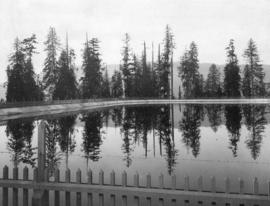
Little Mountain Reservoir July 29 1913.
Part of Major Matthews collection
Photograph also shows a man and his dog beside the reservoir.
![[View of Loch Lomond, North Vancouver]](/uploads/r/null/8/b/8bb90984698bbda6bfe936b6043a47b7a9ddee2c1ec428436f4d11e3bcf1cae3/13ae92f3-6ddc-484d-9494-c5bc3e7bae29-A64489_142.jpg)
[View of Loch Lomond, North Vancouver]
Part of Major Matthews collection
![[An unidentified group standing on a reservoir]](/uploads/r/null/2/f/2fbbb639f64f6c027bd58b826b2d925aa7576f80a3183f95cf23de9868b62f2d/207ab4a3-bd31-4c93-a30e-ee6cb2aae187-A23368_142.jpg)
[An unidentified group standing on a reservoir]
Part of Major Matthews collection
Group portrait
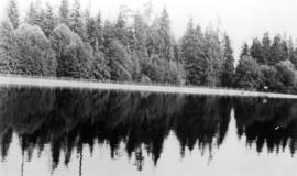
![Reflections in the resevoir [at Stanley Park]](/uploads/r/null/f/1/f1fa87ee07aca1fb09a0c8142f43db4210cb375b90e4d939c4528b2c6b6db27d/9073dc75-38cc-43a5-a3c0-b467c33b8b83-A21488_142.jpg)
Reflections in the resevoir [at Stanley Park]
Part of Major Matthews collection

Part of Major Matthews collection
Part of Major Matthews collection
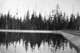
Reservoir in Stanley Park, Vancouver
Part of Major Matthews collection
![[Aerial view of Vancouver]](/uploads/r/null/b/9/b973b9a4143a5316b02e728c35d99e383f27a3db21d8e20aa7bbb459780243bc/3ff38b56-6b36-4c17-bce1-329c97459d29-A66598_142.jpg)
Part of Major Matthews collection
Photograph shows Kitsilano, Kits Point, Kitsilano Beach, R.C.A.F. Equipment Depot, Kitsilano Pool, Burrard Bridge, C.P.R. Kitsilano Trestle, Granville Island, Granville Bridge, Cambie Bridge, False Creek, C.P.R. False Creek Yards, West End, Yaletown, Arbutus Ridge, Shaughnessy, South Cambie, Fairview, Mount Pleasant, Little Mountain Reservoir, Connaught Park, Quilchena Golf Course, Douglas Park, Shaughnessy Heights Golf Course, Queen Elizabeth Park, Royal Canadian Mounted Police Barracks, Shaughnessy Military Hospital, Hillcrest Park, Robertson & Hacket Sawmill, City Yard, West Coast Ship Builders and Athletic Park.