
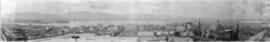
View of Canada Place and Downtown Vancouver
- COV-S477-3-F111-: CVA 775-66
- Item
- [1986 or 1987]
Part of City of Vancouver fonds
617 results with digital objects Show results with digital objects
View of Canada Place and Downtown Vancouver
Part of City of Vancouver fonds

Vancouver skyline from Coal Harbour
Part of City of Vancouver fonds

Vancouver skyline from Coal Harbour
Part of City of Vancouver fonds

Vancouver skyline from Coal Harbour
Part of City of Vancouver fonds

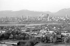
Downtown cityscape over Mount Pleasant, Fairview, and False Creek
Part of City of Vancouver fonds
Item part is a photograph of downtown Vancouver, including a view down Cambie Street across the Cambie Street Bridge, and adjacent neighborhoods in Fairview and Mount Pleasant.

Downtown cityscape over Mount Pleasant, Fairview, and False Creek
Part of City of Vancouver fonds
Item part is a photograph of downtown Vancouver, including a view down Cambie Street across the Cambie Street Bridge, and adjacent neighborhoods in Fairview and Mount Pleasant.

Downtown cityscape over Fairview, and False Creek
Part of City of Vancouver fonds
Downtown cityscape over Mount Pleasant, Fairview, and False Creek
Part of City of Vancouver fonds
Item part is a photograph of downtown Vancouver, including a view down Cambie Street across the Cambie Street Bridge, and adjacent neighborhoods in Fairview and Mount Pleasant.

Downtown cityscape over Fairview and False Creek
Part of City of Vancouver fonds
Item part is a photograph of downtown Vancouver over Fairview and False Creek. The Granville Street Bridge and the Burrard Street Bridge are visible at the far left.

Part of City of Vancouver Archives sound recording and moving image collection
Item is a documentary film documenting bridges, Vancouver Harbour, the Stanley Park (B.C.) seawall, and maritime traffic around Vancouver. The film includes footage of False Creek, the Granville (Street) Bridge (3rd, 1954-), the Burrard Bridge (1932-), the Lions Gate (First Narrows) Bridge (1938-), the Second Narrows Highway Bridge (1960-), the Stanley Park seawall and sculptures including Elek Imredy's sculpture Girl In A Wetsuit and the replica figurehead of the RMS Empress of Japan, the shipping facilities at Vancouver Harbour, and the seabus terminal. The film also includes footage of boats and ships including a sailboat, tugboat, cruise ship, seabus, ferry, and cargo ships.
Item is a photograph showing downtown Vancouver from English Bay with Beach Avenue and Jervis Street and the former Tudor Manor apartment building visible.
Summer 1982 - Aerial shot from the south side of False Creek before Expo
Item is a photograph showing housing complexes along the south shore of False Creek and on the north side construction has begun for the Expo 86 site and BC Place Stadium is under construction, past the Cambie Bridge on the right.
Aerial of Vancouver, B.C. [over False Creek]
Item is a photograph showing the Burrard Street Bridge, former train trestle and the West End neighbourhood as well as other parts of downtown.
[View from downtown looking southeast]
Item is a photograph taken from [Harbour Centre?] showing a view of downtown and the east end of False Creek around Main and Terminal Avenue. Photograph includes the Georgia Viaduct and in the foreground are buildings along Hastings, Pender, Cambie, Beatty Streets including the Sun Tower, Woodward's, the Dominion Building and part of Victory Square.
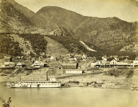
Photograph shows the paddle-wheeler "William Irving", the Railroad House, Caledonian Hotel, Steamboat Exchange, a church and other buildings

Vancouver, B.C., Canada : the city from Little Mountain

No. 1036, Vancouver B.C. looking East
Item is a postcard printed with an image of Vancouver looking east. The back of the postcard includes personal correspondence addressed to Mrs. Peter [Hanson].

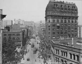
Looking down Granville Street, Rogers Building on right, C.P.R. Station in distance
Looking west up Hastings showing Flack Block and Dominion Building

Greetings from Vancouver, Canada
Item is a postcard showing two images of Vancouver: entrance to Stanley Park (top) and Vancouver Skyline from Stanley Park (bottom).

Vancouver, B.C., Canada : West End and park - looking west to Point Atkinson
Item is a postcard showing an aerial view of the West End and Stanley Park. Caption on back of postcard: "Aerial view showing the Burrard Inlet; part of Downtown Vancouver; Stanley Park; the Lions Gate Bridge; West Vancouver and the North Shore Mountains."

No. 1036 : Vancouver, B.C. looking east
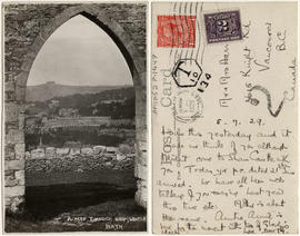
A peep through Sham Castle, Bath.
This postcard includes personal correspondence. Sent to Mr. and Mrs. [Harrison?] of Vancouver, B.C.
![Bahia de Guaymas [Sonora]](/uploads/r/null/9/1/7/91770ee2f858f4a3f5c7a351ea978063bd6724183b44ae2e83a2c10db91d6f81/abc0454d-c46a-4dde-a359-31fcba3ad6bd-AM1052P-1301_142.jpg)

This postcard includes personal correspondence. Sent to Miss Baggs of Bath, England.

Town of Lytton From Railway Looking North
Part of Major Matthews collection
![[Panoramic view of downtown, Vancouver from Granville and Hastings Streets]](/uploads/r/null/2/1/6/216cf899114250d1b31f38600b649f3b49bbd0c5882c6b5a6a9519d124d69cd5/addbb40b-0fc9-430e-8ebb-76d531606378-PANP92_142.jpg)
[Panoramic view of downtown, Vancouver from Granville and Hastings Streets]
Part of Major Matthews collection
Photograph is almost a 360 degree view. Buildings and some landmarks are identified in ink on print. This is a cropped version of PAN P92.1.
Written on the back of the print in what appears to be Major J.S. Matthews writing:
"Building permits issued.
Court House, superstructure, 7 Dec 1907 (addition, 30/3/1912)
excavation, 8 Mar 1907
Dominion Trust 21 Apr 1908
Carter-Cotton Bldg (Province Bldg) 5 Oct 1908 (addition Pender St 14/11/10)
Street cars and vehicles:- left hand rule of the road until 1921.
Have not investigated but this looks July or August 1908 or perhaps July-Aug 1909"
![[View of the West End looking south taken from the B.C. Hydro building]](/uploads/r/null/6/8/68c2fd1f00238145f7332ebfc1a7925817f85ffb755220156553cc0888929586/e05527e0-9680-4637-97a7-ebec09662736-A10239_142.jpg)
[View of the West End looking south taken from the B.C. Hydro building]
Part of Major Matthews collection
Photograph shows Sir William Dawson School, St. Paul's Hospital, buildings along Burrard, Hornby and Granville, and the Burrard and Granville Street bridges
![[View of] Anyox, B.C.](/uploads/r/null/7/2/6/726fe59560c618f43f32718b12a695effd3ffa7bb87f511e5c38e1f11644dd8f/3aa3ddc9-e711-4c4d-9e4b-b50148789010-LP312_142.jpg)
Part of Major Matthews collection
Panoramic view shows wooden streets and sidewalks, clear cut logging and Consolidated Mining and Smelting Co.
![[View of] Kamloops, B.C.](/uploads/r/null/3/7/373dfc39ba6af8d74ee12ec59df0ad0c1d5597d0987cf8be727856b5cb3b7827/4e3cdfd5-601e-4d16-8eab-b939dd6efa3c-A32240_142.jpg)
Part of Major Matthews collection
![[View looking north from City Hall]](/uploads/r/null/b/8/b8b148471adeeda1d474e22df99b6cbf4828348d3e0de9893a4cd829fd983d34/861b0f19-6993-427f-be6c-1a3fae20fedf-A23505_142.jpg)
[View looking north from City Hall]
Part of Major Matthews collection
![[View of a country village in Quebec]](/uploads/r/null/a/4/a4418d2b7d228b2e82c430f2fd4c88d64942b73bbe05bff15885b02a036ea1fe/7a94c279-af5a-4046-972d-521da414268a-A33157_142.jpg)
[View of a country village in Quebec]
Part of Major Matthews collection

Medecine Hat and Saskatchewan River
Part of Major Matthews collection

New Westminster, British Columbia
Part of Major Matthews collection
Photograph shows Royal Columbian Hospital, Irving House and St. Andrew's Presbyterian Church.
![[View of Lillooet]](/uploads/r/null/5/0/50f146e9e439fcd3bf14d29759d31dd388474f6b6499911ed7cf6bf60240d3fc/0597e9d1-1aaf-4e27-85a7-e55da6328188-A33598_142.jpg)
Part of Major Matthews collection
Part of Major Matthews collection
Photograph also shows Coal Harbour, the second Hotel Vancouver under construction.
![[Northern view of downtown Vancouver from the World Building at 500 Beatty Street]](/uploads/r/null/c/5/c5a97982fe48806e527a2356c3596800ee386904520184558d1eb65128635907/f3ea7ce2-2a4c-40da-a5a9-2ccfa6c170b1-A63886_142.jpg)
[Northern view of downtown Vancouver from the World Building at 500 Beatty Street]
Part of Major Matthews collection
Photographs shows Central Public and Vancouver High Schools, the Dominion Bank and Vancouver Daily Province Buildings, Coal Harbour, C.P.R. Pier D and Deadman's Island and the North Shore in the background

Part of Major Matthews collection
Photograph also shows the second phase of the Hudson's Bay Co., the third Hotel Vancouver, Marine, David Spencer and Georgia Medical Dental buildings and the Georgia, Dunsmuir and Devonshire Hotels, the Dominion Building (207 West Hastings Street) and Holy Rosary Cathedral. The North Shore Ferry also can be seen crossing Burrard Inlet.

Part of Major Matthews collection
![[Northwest view of Vancouver from the roof of City Hall]](/uploads/r/null/3/4/3414c21c5f2579e5b59298a8b9442a1267b6909328330d8427dcd73601bad1e8/a0efd618-3a6b-4497-8a0d-8adfd415df58-A31896_142.jpg)
[Northwest view of Vancouver from the roof of City Hall]
Part of Major Matthews collection
Panoramic view showing northern sections of Fairview and Mount Pleasant, Cambie bridge, False Creek, Yaletown and downtown
![[Northern view from top of old Hotel Vancouver]](/uploads/r/null/3/7/37da1c6b69e3d7db2beda19a44ddfaa7ed2580adbcc6262f926caaab84327420/773eda9d-80c9-493b-926e-3bccd244d01f-A21939_142.jpg)
[Northern view from top of old Hotel Vancouver]
Part of Walter E. Frost fonds
Photograph shows the Marine Building, Immigration building and Deadman's Island.

Vancouver looking north from City Hall, 1936

Vancouver looking south from City Hall, 1936


Gardens - United States : Portland
Image shows view of rose garden with cityscape in background.

Image shows an aerial view of the west end of Vancouver looking south.

Image shows aerial view of Vancouver and North Shore.
![Abbotsford, B.C. - [bird's eye view of the Main Street]](/uploads/r/null/9/0/9072ea1f18d145e4b00480e5e7fb99487d2ae236d00f7af910767d847883d11d/8ac55989-8265-4745-bf65-092310951316-A16924_142.jpg)
Abbotsford, B.C. - [bird's eye view of the Main Street]
Part of Stuart Thomson fonds