![Cityscape [3 of 16]](/uploads/r/null/1/1/113362fa3fe4b50a19fdac9053273dc6622e04b5b21a35989c3becce0ef62dba/1a32affc-0772-4a49-84a9-295338a56467-A66157_142.jpg)
- COV-S663-: CVA 800-1967
- Item
- Apr. 1973
Part of City of Vancouver fonds
617 results with digital objects Show results with digital objects
Part of City of Vancouver fonds
![Cityscape [2 of 16]](/uploads/r/null/0/5/054ac0b7f29d57859ab09b04d66952d9dbeb15353f0f4f8c1e97e89e8fc935f6/832f8179-4710-4ebf-8824-7eb17d97c9e8-A66156_142.jpg)
Part of City of Vancouver fonds
![Cityscape [1 of 16]](/uploads/r/null/2/b/2bdbafa2e214923e658beea80944c5c66b6d0ed374eeed87fe5f15c6f3d53b93/3f7c562e-087a-44f3-9676-e56fa25889db-A66155_142.jpg)
Part of City of Vancouver fonds
![Cityscapes [16 of 16]](/uploads/r/null/b/7/b7667822b216995a57d222274b72bd43312c9e95aa86247deb3ad6ccd27484b3/4a41b521-088c-4ad6-bcbd-f66ea684f237-A66154_142.jpg)
Part of City of Vancouver fonds
![Cityscapes [15 of 16]](/uploads/r/null/5/1/5142e0b083338c6d763f4f26e851bd740d64e0c9c806eae353716bf7f42817b3/6e1cbbc4-185d-47e7-a75f-5672adae116f-A66153_142.jpg)
Part of City of Vancouver fonds
![Cityscapes [14 of 16]](/uploads/r/null/d/c/dc8b6f46c6da6df6153b29b4f482318112d613003e863ee7e202f34c821e6d44/554363ed-722d-4ea1-934b-4ed83687cc9e-A66152_142.jpg)
Part of City of Vancouver fonds
![Cityscapes [13 of 16]](/uploads/r/null/2/5/25bb98d9339b0d77dec78c2cfda2270ecc7dea0d89abbc2ad17661693415b360/a2925e9d-8119-44ba-8cce-e020077ffe6a-A66151_142.jpg)
Part of City of Vancouver fonds
![Cityscapes [12 of 16]](/uploads/r/null/b/a/ba822ca521a9ddde92e26be32d085bdd73fb7a043ea810a0232f43577aac41b0/0a194d9e-c80c-4c91-9cf1-e6ab98ca7048-A66150_142.jpg)
Part of City of Vancouver fonds
![Cityscapes [11 of 16]](/uploads/r/null/6/4/6434c71eb8fd42ef6be57e5fd4c322cadf393b8d170ece56a5ce40cbc4711b60/0143c4f9-db95-4780-81b0-ef394b33b181-A66149_142.jpg)
Part of City of Vancouver fonds
![Cityscapes [10 of 16]](/uploads/r/null/4/1/4175e8b30caf66fda910add640ef21dc6bb0c627cb7a6a1faf8944a1dbd90552/4cce59c4-efdf-4e37-8ec5-ce0da5b5f2c7-A66148_142.jpg)
Part of City of Vancouver fonds
![Cityscapes [9 of 16]](/uploads/r/null/3/4/34e0757ad07a6cad17d8633d43ef73c8dea854d720aaf343b5f2702c1c2fb6ac/4717f7d7-6c29-4ef1-bea3-a51d4cb027af-A66147_142.jpg)
Part of City of Vancouver fonds
![Cityscapes [8 of 16]](/uploads/r/null/b/3/b31eec8a3c82cee3ce154505eced1e5b194b78fcf792c9c59fe0204008d532f2/2cd8bdda-7762-41f0-93dd-430f08b6d8d6-A66146_142.jpg)
Part of City of Vancouver fonds
![Cityscapes [7 of 16]](/uploads/r/null/b/4/b4b359f40cf2c5a86eda4dc25c9c00ecc1c09a47710344e1a6e842ab885acad7/f2235b0e-4c20-42cd-968d-dc884166b483-A66145_142.jpg)
Part of City of Vancouver fonds
![Cityscapes [6 of 16]](/uploads/r/null/6/0/60c919e64c6693ce343576e1f3f3b3a5dbc253a1e9eb9b246f0284ef08413261/4436528c-4b57-420a-858f-0a565aa47925-A66144_142.jpg)
Part of City of Vancouver fonds
![Cityscapes [5 of 16]](/uploads/r/null/c/2/c2f2d297302fa554cff1f17b6190e01b6d3b437f44ea987f73ec7283aab5d49d/1c81641f-4647-4381-ad8c-8edc6b0f3f3e-A66143_142.jpg)
Part of City of Vancouver fonds
![Cityscapes [4 of 16]](/uploads/r/null/4/8/48e1d6f8b1222bdbf9a7d9328ecc76249e71dc85cd0419bc1f8d96dfe6743703/35e42530-6b3f-49de-9e6f-aa582bc5b97a-A66142_142.jpg)
Part of City of Vancouver fonds
![[City lookout, possibly along Chancellor Boulevard, 2 of 2]](/uploads/r/null/c/6/d/c6dc2aad70263d1e91a2d0ab75cb2f45967f109c3e92c89adb0692ffda0a495b/4725291a-f337-4fa5-85fd-41ed165d6380-CVA1095-08693_142.jpg)
[City lookout, possibly along Chancellor Boulevard, 2 of 2]
Part of City of Vancouver fonds
![[City lookout, possibly along Chancellor Boulevard, 1 of 2]](/uploads/r/null/5/c/b/5cbab1701ebb3167697e9b6d0f393e17c3e37c52aadf93977a4129bd7ec648ad/163ffa2e-bfb5-473f-8654-be14119de72e-CVA1095-08692_142.jpg)
[City lookout, possibly along Chancellor Boulevard, 1 of 2]
Part of City of Vancouver fonds
Part of City of Vancouver fonds
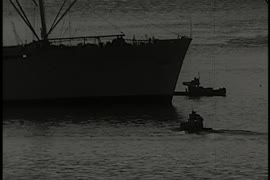
Item is a documentary film documenting the transportation and population issues that impact access to downtown Vancouver. Film contains scenes of driving on the Granville Street Bridge, people attending a show, on a beach and walking around city streets at both daytime and evening.
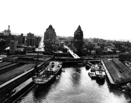
Aerial view of Pier B, C and A at the foot of Burrard Street
Part of City of Vancouver fonds

Aerial view of Coal Harbour and Stanley Park
Part of City of Vancouver fonds

Aerial view of Burrard Street and surrounding area
Part of City of Vancouver fonds

Aerial view of the City of Vancouver, Redevelopment Project No. 1
Part of City of Vancouver fonds

Aerial view of the downtown core, post office under construction
Part of City of Vancouver fonds

Downtown cityscape over Fairview and False Creek
Part of City of Vancouver fonds
Item part is a photograph of downtown Vancouver over Fairview and False Creek. The Granville Street Bridge and the Burrard Street Bridge are visible at the far left.

Downtown cityscape over Mount Pleasant, Fairview, and False Creek
Part of City of Vancouver fonds
Item part is a photograph of downtown Vancouver, including a view down Cambie Street across the Cambie Street Bridge, and adjacent neighborhoods in Fairview and Mount Pleasant.

Downtown cityscape over Mount Pleasant, Fairview, and False Creek
Part of City of Vancouver fonds
Item part is a photograph of downtown Vancouver, including a view down Cambie Street across the Cambie Street Bridge, and adjacent neighborhoods in Fairview and Mount Pleasant.
Downtown cityscape over Mount Pleasant, Fairview, and False Creek
Part of City of Vancouver fonds
Item part is a photograph of downtown Vancouver, including a view down Cambie Street across the Cambie Street Bridge, and adjacent neighborhoods in Fairview and Mount Pleasant.

Downtown cityscape over Mount Pleasant, Fairview, and False Creek
Part of City of Vancouver fonds
Item part is a photograph of downtown Vancouver, including a view down Cambie Street across the Cambie Street Bridge, and adjacent neighborhoods in Fairview and Mount Pleasant.

Downtown cityscape over Mount Pleasant, Fairview, and False Creek
Part of City of Vancouver fonds
Item part is a photograph of downtown Vancouver, including a view down Cambie Street across the Cambie Street Bridge, and adjacent neighborhoods in Fairview and Mount Pleasant.

Vancouver City Hall from the southwest
Part of City of Vancouver fonds

Downtown cityscape over Mount Pleasant, Fairview, and False Creek
Part of City of Vancouver fonds
Item part is a photograph of downtown Vancouver, including a view down Cambie Street across the Cambie Street Bridge, and adjacent neighborhoods in Fairview and Mount Pleasant. The Granville Street Bridge and the Burrard Street Bridge are visible at the far left.

Downtown cityscape over Fairview, and False Creek
Part of City of Vancouver fonds
Downtown cityscape over Mount Pleasant, Fairview, and False Creek
Part of City of Vancouver fonds
Item part is a photograph of downtown Vancouver, including a view down Cambie Street across the Cambie Street Bridge, and adjacent neighborhoods in Fairview and Mount Pleasant.

Downtown cityscape over Mount Pleasant, Fairview, and False Creek
Part of City of Vancouver fonds
Item part is a photograph of downtown Vancouver, including a view down Cambie Street across the Cambie Street Bridge, and adjacent neighborhoods in Fairview and Mount Pleasant.

Downtown cityscape over Fairview, and False Creek
Part of City of Vancouver fonds

Downtown cityscape over Mount Pleasant, Fairview, and False Creek
Part of City of Vancouver fonds
Item part is a photograph of downtown Vancouver, including a view down Cambie Street across the Cambie Street Bridge, and adjacent neighborhoods in Fairview and Mount Pleasant.

Downtown cityscape over Mount Pleasant, Fairview, and False Creek
Part of City of Vancouver fonds
Item part is a photograph of downtown Vancouver, including a view down Cambie Street across the Cambie Street Bridge, and adjacent neighborhoods in Fairview and Mount Pleasant.

Downtown cityscape over Mount Pleasant and False Creek
Part of City of Vancouver fonds

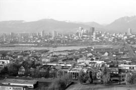
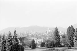
Downtown view over Fairview neighborhood
Part of City of Vancouver fonds
Item part is a photograph of the top of the downtown Vancouver skyline over the trees of a Fairview neighborhood. This photograph was taken from one of the lower floors of the Plaza 500 Hotel & Convention Centre.

Downtown view over Fairview neighborhood
Part of City of Vancouver fonds
Item part is a photograph of the top of the downtown Vancouver skyline over the trees of a Fairview neighborhood. This photograph was taken from one of the lower floors of the Plaza 500 Hotel & Convention Centre.
Downtown view over Fairview neighborhood
Part of City of Vancouver fonds
Item part is a photograph of the top of the downtown Vancouver skyline over the trees of a Fairview neighborhood. This photograph was taken from one of the lower floors of the Plaza 500 Hotel & Convention Centre.
Vancouver Cityscapes - Downtown, Fairview, Mount Pleasant
Part of City of Vancouver fonds
Item is a set of negatives of cityscape photographs taken mostly from the upper floors of the Plaza 500 Hotel & Convention Centre at 500 W. West 12th Avenue, at the intersection of West 12th Avenue and Cambie Street, looking north. The subject material of the photographs is predominantly downtown Vancouver, the North Shore Mountains, False Creek, and the Fairview and Mount Pleasant neighbourhoods. This set contains the raw photographs from the roll the photographer shot in their original order. The associated contact sheet has selection marks for frames 16, 21, 23, and 25.

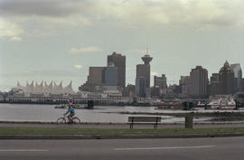
View of Canada Place and Downtown Vancouver
Part of City of Vancouver fonds

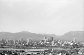
Vancouver skyline from Coal Harbour
Part of City of Vancouver fonds
Vancouver skyline from Coal Harbour
Part of City of Vancouver fonds

Vancouver skyline from Coal Harbour
Part of City of Vancouver fonds

Vancouver skyline from Coal Harbour
Part of City of Vancouver fonds