Vancouver B.C. [from the air looking east from West End]
[Aerial view looking east of downtown Vancouver and the waterfront]
[View of the West End looking south taken from the B.C. Hydro building]
[Northern and eastern view of] Vancouver, B.C. [showing Burrard Inlet, Downtown, False Creek and Yaletown]
[Panoramic view of Vancouver looking east, south and west from the Post Office tower]
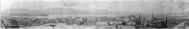
[Panoramic view of downtown, Vancouver from Granville and Hastings Streets]
[Panoramic view of downtown, Vancouver from Granville and Hastings Streets]
[Panoramic view of downtown, Vancouver from Granville and Hastings Streets]
[Panoramic view of] Dawson City Y.T. [and surrounding area during the gold rush]
Vancouver B.C. 1922 [panoramic view of downtown from Burrard Street and Nelson Street]
[View of downtown from the Dominion Trust building showing Burrard Inlet and the North shore]
[North to north east view of downtown from the Birks Building showing Burrard Inlet and the North shore in the background]
[North to north east view of downtown from the Birks Building showing Burrard Inlet and the North shore in the background]
[View of Fairview and Mount Pleasant from the roof of City Hall, 12th Avenue and Cambie Street]
Vancouver from Little Mountain Park
[Vancouver from Little Mountain Park]
[View of downtown Vancouver looking north from the top of the Dominion Trust Building, 402 West Pender Street] showing the waterfront and the North Shore in the background
[View of Pier "D" and downtown Vancouver near the waterfront from the Terminal City Club, 837 Hastings Street]
[Eastward view of downtown from the Terminal City Club, 837 Hastings Street, showing Pier D]
[Northern view of downtown Vancouver from World Building, 500 Beatty Street]
[Southward view of downtown Vancouver from the World Building Showing False Creek]
[Northern view of downtown Vancouver from the World Building at 500 Beatty Street]
[Northern view of downtown Vancouver from the World Building at 500 Beatty Street]
[Northward view of Downtown Vancouver from the tower of the Vancouver Block]
[360 degree view of Vancouver from the roof of the second Hotel Vancouver]
[View of Ashcroft, B.C.]
[View of North Vancouver and The Lions]
[View of Lillooet]
[View of Lillooet]
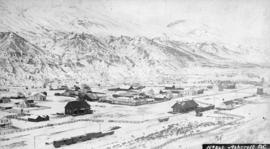
Ashcroft, B.C.
Town of Lytton From Railway Looking North
[View of Lillooet]
[View of Lillooet]
[View of Nelson]
General View Revelstoke, B.C.
View of Dawson City during the Klondike Gold Rush
[View of Whatcom (Bellingham)]
[View of Whatcom (Bellingham)]
[View of Whatcom (Bellingham)]
[View of Lytton on the Fraser River]
[View of a country village in Quebec]
[View of Lillooet, B.C.]
James Bay, Victoria
New Westminster, British Columbia
Barkerville - Williams Creek, Cariboo, "Gold Mines"
Yale [on the] Fraser River - The head of navigation
![Vancouver B.C. [from the air looking east from West End]](/uploads/r/null/a/3/a39a59fafd2c470a05e0b8ecba90843c0dcefd64faa8cd1695e25e8515c52ad7/4a63a71b-9508-45ea-b75a-27924fe36db8-A42964_142.jpg)
![[Aerial view looking east of downtown Vancouver and the waterfront]](/uploads/r/null/a/1/a146c28159c45997dd3312d8a94967907da12e5b5c1139902f95665ab0e54675/740905a3-6e61-4ffc-bc08-d90ad82bc7d8-A67011_142.jpg)
![[View of the West End looking south taken from the B.C. Hydro building]](/uploads/r/null/6/8/68c2fd1f00238145f7332ebfc1a7925817f85ffb755220156553cc0888929586/e05527e0-9680-4637-97a7-ebec09662736-A10239_142.jpg)
![[Northern and eastern view of] Vancouver, B.C. [showing Burrard Inlet, Downtown, False Creek and ...](/uploads/r/null/a/d/ad499a709643b866df0dd06ee0db3a33d39d0fae463dc917d66f4f31c3dac3ad/05fca819-4e81-4708-982c-e3af142f77cb-A63163_142.jpg)
![[Panoramic view of Vancouver looking east, south and west from the Post Office tower]](/uploads/r/null/3/4/3440da1e98108d2cb1b9e915b9d5784f1ce26f037ac1f6597fb6f283670ef6fa/d87fd6ce-c19b-43e2-af52-69db5b1e0d1e-A63166_142.jpg)
![[Panoramic view of downtown, Vancouver from Granville and Hastings Streets]](/uploads/r/null/b/6/b/b6b44d6ac0fb2fd61907ae9bad2a5792f8dce904b90fa1406d9c99ea2d36ee94/a76ddde8-2b68-4786-82cb-14470e682cd1-PANP92_142.jpg)
![[Panoramic view of downtown, Vancouver from Granville and Hastings Streets]](/uploads/r/null/2/1/6/216cf899114250d1b31f38600b649f3b49bbd0c5882c6b5a6a9519d124d69cd5/addbb40b-0fc9-430e-8ebb-76d531606378-PANP92_142.jpg)
![[Panoramic view of downtown, Vancouver from Granville and Hastings Streets]](/uploads/r/null/0/6/5/06580a3600086447b57072066927ba44f3c0dc4a7a9332d2e22592909ad9480e/c2c55e1f-01d3-47c6-b79d-aa85a7835684-PANP92_142.jpg)
![[Panoramic view of] Dawson City Y.T. [and surrounding area during the gold rush]](/uploads/r/null/5/0/506e42684abd11564a15b6ed320519f1fdfe76b93282f62a101c43cb73368b4c/aef0d3ce-b0eb-45e2-8d0a-f639840ce71b-A64736_142.jpg)
![Vancouver B.C. 1922 [panoramic view of downtown from Burrard Street and Nelson Street]](/uploads/r/null/0/7/0768fe60d947891f5c39dda8a39e3a24efeae82bdebd1add91298c0924509c1b/890de502-6c21-4a04-a71a-388e44166aec-A64784_142.jpg)
![[View of downtown from the Dominion Trust building showing Burrard Inlet and the North shore]](/uploads/r/null/7/c/7cb069fc4b2e111566d6d005964b40e51b0cd1c5120ff8a4144f8a14970b897b/9ed5b7c3-1cce-459b-bed5-11a9069eda9f-A64132_142.jpg)

![[View of Fairview and Mount Pleasant from the roof of City Hall, 12th Avenue and Cambie Street]](/uploads/r/null/2/0/208e68631777759d5511724cf523f405aab570c60b1d072c6544c204a02ba55a/951a4b6a-e3a5-418c-820c-f6393e92282c-A63177_142.jpg)

![[Vancouver from Little Mountain Park]](/uploads/r/null/f/7/f7eff772efc6cb875bec8e461625b4d092a060d696e7230e3110603a63745e44/7dd608d7-f838-4ffa-b171-fff4e76afbeb-A63889_142.jpg)


![[Eastward view of downtown from the Terminal City Club, 837 Hastings Street, showing Pier D]](/uploads/r/null/9/5/9523884236697e596af802e7cf7ced23b8df0cd4ef660a464f06c85f65edffda/1378bd7b-721e-4359-9c81-115ebad704ee-A63887_142.jpg)
![[Northern view of downtown Vancouver from World Building, 500 Beatty Street]](/uploads/r/null/9/9/997cc0ffa3d5b19d17a58c9f16a1c6f9855c9019e5f3249c78d456803ea58779/b52f219d-f015-40b1-96a6-c089ab3c8d70-A63175_142.jpg)
![[Southward view of downtown Vancouver from the World Building Showing False Creek]](/uploads/r/null/1/7/178f284a66576bceb511c02e64571346636be935788ca2d242360ace33cc373b/e71f53d7-3e88-4628-9058-9eca3b428398-A63174_142.jpg)
![[Northern view of downtown Vancouver from the World Building at 500 Beatty Street]](/uploads/r/null/c/5/c5a97982fe48806e527a2356c3596800ee386904520184558d1eb65128635907/f3ea7ce2-2a4c-40da-a5a9-2ccfa6c170b1-A63886_142.jpg)
![[Northern view of downtown Vancouver from the World Building at 500 Beatty Street]](/uploads/r/null/9/5/95cc16c6b26e463eb28bc5ac8abec9ec6723150a2aefbca7850f264a2adff766/e88985ba-abeb-4d06-8eea-2bf10a834381-A63885_142.jpg)
![[Northward view of Downtown Vancouver from the tower of the Vancouver Block]](/uploads/r/null/7/e/7e88d0ca5a3c8b27417b0772731b3b9c8e8116caba7efef77325c3bfdf9ef14d/7ff76790-0eb3-4328-b584-8e7978589537-A63884_142.jpg)
![[360 degree view of Vancouver from the roof of the second Hotel Vancouver]](/uploads/r/null/7/2/72f205b48502a927912ec46b74aa571f102f387013c2d6bce557a2420fd72aa7/269934f7-d517-4c58-b633-4167772f935b-A63168_142.jpg)
![[View of Ashcroft, B.C.]](/uploads/r/null/3/e/3ec4dfdcd1ef4ab3d7c12c395894dbd503c82670a93e64bfefa2f35861277c72/49d73b7e-d7bd-4907-a526-89e9a94ef7bf-A26834_142.jpg)
![[View of North Vancouver and The Lions]](/uploads/r/null/5/5/55a2e0b64168dac5001086cb1e39ff3a042171870761cdbc8dd7a978bbfeefb8/ee325cd7-cbf8-4140-9f03-6811c0625a8b-A26825_142.jpg)
![[View of Lillooet]](/uploads/r/null/d/f/df456431e135a533d10a2ab0408b11cf7c96d6d2f996cdae81d8b194c919d26a/03feaee7-1d13-40b5-8102-51053ff47c1c-A33682_142.jpg)
![[View of Lillooet]](/uploads/r/null/a/5/a59e13fe3d8ed931caa08cbdee4e8dfb631d4cf38eaa9132f534581f725510eb/69f535e2-8e92-43ae-b95a-e7a92be1f7ed-A33681_142.jpg)

![[View of Lillooet]](/uploads/r/null/d/7/d7599a4ef2952182c63a7487211cd218874a1992472bf88049d0f3c475709c1c/d1331256-b8fe-46ae-9972-a0bca9ae5153-A33609_142.jpg)
![[View of Lillooet]](/uploads/r/null/5/0/50f146e9e439fcd3bf14d29759d31dd388474f6b6499911ed7cf6bf60240d3fc/0597e9d1-1aaf-4e27-85a7-e55da6328188-A33598_142.jpg)
![[View of Nelson]](/uploads/r/null/2/1/2168958d3457cb3ca712fef4e44c8ce4055891c41a954007b0750707b5dc12d3/3be10139-bcea-4555-bfdc-f6f275d78b21-A33432_142.jpg)


![[View of Whatcom (Bellingham)]](/uploads/r/null/d/3/d3500799c36b679cba68aa22e7dcc3cfa855ffc645b4ca3ba94b0a95c67f1119/78c9ea15-9046-47b3-b330-e27d22a62426-A33314_142.jpg)
![[View of Whatcom (Bellingham)]](/uploads/r/null/1/d/1d0b1ddbccb58e63531e08c977775fb74519a32b85f14a1c4ade3d3df4c2a7a6/fad20b24-5065-4017-be11-92fcc1cc6281-A33313_142.jpg)
![[View of Whatcom (Bellingham)]](/uploads/r/null/0/4/04cd681dedd30f1d9e58d5ee0d3b7c661cdf0885c3827b1e5a8cfb217f108de8/e598c73d-58bf-4700-9c7a-e7aefe419f4f-A33312_142.jpg)
![[View of Lytton on the Fraser River]](/uploads/r/null/1/9/194eee99a7fc6c14ee20a84e2980955546a25df285914108d4dfa3c3358a3a2e/3e834be8-0204-4276-b389-d1137f650c82-A33311_142.jpg)
![[View of a country village in Quebec]](/uploads/r/null/a/4/a4418d2b7d228b2e82c430f2fd4c88d64942b73bbe05bff15885b02a036ea1fe/7a94c279-af5a-4046-972d-521da414268a-A33157_142.jpg)
![[View of Lillooet, B.C.]](/uploads/r/null/0/1/016397dcce4d79f6081a6c5e8540b46435b0d8c5d734afa3f47f42e2ca9555f0/168c8877-6711-4144-a370-5e9c4d8eaf84-A33102_142.jpg)


![Yale [on the] Fraser River - The head of navigation](/uploads/r/null/d/9/d958fdf210351fa4041e911a6962b6343ec9026647a3c5bad699fdbb3ff62e8b/505bb42d-8ab1-4c81-8073-ecf64cc620c4-A26890_142.jpg)


![[View of] Kamloops, B.C.](/uploads/r/null/3/7/373dfc39ba6af8d74ee12ec59df0ad0c1d5597d0987cf8be727856b5cb3b7827/4e3cdfd5-601e-4d16-8eab-b939dd6efa3c-A32240_142.jpg)