
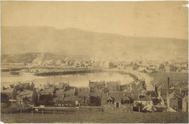
Barkerville - Williams Creek, Cariboo, "Gold Mines"
- AM54-S4-: Out P165
- Item
- [ca. 1865]
Part of Major Matthews collection
613 results with digital objects Show results with digital objects
Barkerville - Williams Creek, Cariboo, "Gold Mines"
Part of Major Matthews collection

Part of Major Matthews collection
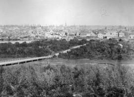
Part of Major Matthews collection
Photograph also shows a bridge in the foreground.
Part of Major Matthews collection
Photograph shows a waterfront view and First Nations dwellings in the foreground.
![[Water front view of] Victoria - Vancouver Island]](/uploads/r/null/9/b/9bd7fa4c80a8257c626eeb02c568e3d3fdcfe887feb124cd812a5a42d311ddb7/f7cca73b-6d9e-459b-87c4-c12ac90e3e03-A22901_142.jpg)
[Water front view of] Victoria - Vancouver Island]
Part of Major Matthews collection
Photoraph shows First Nations dwellings and a ship.
![[Waterfront view of Yale - Frazer [Fraser] River](/uploads/r/null/c/b/cb93dac894f555448d19c45ef7ca3ab754bd1169c311d9479183cb3bc3b1ce24/1c23e657-aa7a-49ac-8784-e7f1a94285cb-A22912_142.jpg)
[Waterfront view of Yale - Frazer [Fraser] River
Part of Major Matthews collection
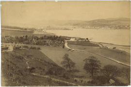
![[View of] Nanaimo V.I. [from across an inlet]](/uploads/r/null/6/2/62659d2754f490eb3b5ddf820063123abd9ad49785d730da10d0f0aed2e2de83/832f0453-fd91-46b8-a9d9-c1ea14c58c1a-A22865_142.jpg)
[View of] Nanaimo V.I. [from across an inlet]
Part of Major Matthews collection
![[Water front view of] Victoria - Vancouver Island](/uploads/r/null/1/e/1ea5ac5232ce347150bb2adc57b2cdd46c02c9ae5a27195dabef08266325d708/3289bb93-2812-4511-ae59-5b62297865d5-A22900_142.jpg)
[Water front view of] Victoria - Vancouver Island
Part of Major Matthews collection

Part of Major Matthews collection
Photograph shows Christ Church Cathedral
![Oaklands [Oakland] - opposite San Francisco](/uploads/r/null/0/b/0bf8abeabe3284efbe6d52ae3a9b98e07bfefee5bf08447952070b396993421d/f5726b8f-fe1a-48c9-81d6-418a1eecf8a8-A23084_142.jpg)
Oaklands [Oakland] - opposite San Francisco
Part of Major Matthews collection

Part of Major Matthews collection
Photograph shows the buildings and waterfront at Victoria.
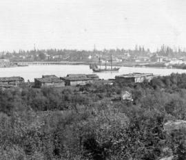
Part of Major Matthews collection
Photograph shows First Nations dwellings in the foreground.

San Francisco from Russian Hill
Part of Major Matthews collection
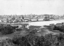
Photograph shows the paddle-wheeler "William Irving", the Railroad House, Caledonian Hotel, Steamboat Exchange, a church and other buildings

New Westminster, British Columbia
Part of Major Matthews collection
Photograph shows Royal Columbian Hospital, Irving House and St. Andrew's Presbyterian Church.

![Yale [on the] Fraser River - The head of navigation](/uploads/r/null/d/9/d958fdf210351fa4041e911a6962b6343ec9026647a3c5bad699fdbb3ff62e8b/505bb42d-8ab1-4c81-8073-ecf64cc620c4-A26890_142.jpg)
Yale [on the] Fraser River - The head of navigation
Part of Major Matthews collection

Part of Major Matthews collection

Town of Lytton From Railway Looking North
Part of Major Matthews collection
![City looking east on Hastings Street [showing] Bank of Montreal](/uploads/r/null/4/5/c/45ce0c6f9b3196306acb7241e627a6efbf94f7f9dcbc23bb5283de2e564ea1e9/166a3e06-7bf1-434f-9f25-4ecfe850dfcf-2011-010_142.jpg)
City looking east on Hastings Street [showing] Bank of Montreal

City looking east from Georgia and Granville Streets
![[View of Lillooet, B.C.]](/uploads/r/null/0/1/016397dcce4d79f6081a6c5e8540b46435b0d8c5d734afa3f47f42e2ca9555f0/168c8877-6711-4144-a370-5e9c4d8eaf84-A33102_142.jpg)
Part of Major Matthews collection

City looking north from Seventh Avenue and Main Street

Medecine Hat and Saskatchewan River
Part of Major Matthews collection
Part of John Girvan fonds
Panoramic view. Image is one of two panoramas mounted on board to show the changes in the cityscape between circa 1890 and 1923.

Medicine Hat and Saskatchewan River
Part of Major Matthews collection
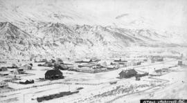
![[View of Ashcroft, B.C.]](/uploads/r/null/3/e/3ec4dfdcd1ef4ab3d7c12c395894dbd503c82670a93e64bfefa2f35861277c72/49d73b7e-d7bd-4907-a526-89e9a94ef7bf-A26834_142.jpg)
Part of Major Matthews collection

Part of John Girvan fonds
Part of John Girvan fonds
Part of Major Matthews collection

City looking east from R.C. Church on Richards Street
![[View of Lillooet]](/uploads/r/null/d/f/df456431e135a533d10a2ab0408b11cf7c96d6d2f996cdae81d8b194c919d26a/03feaee7-1d13-40b5-8102-51053ff47c1c-A33682_142.jpg)
Part of Major Matthews collection

City looking west from Dunlevy Street
![[View of Lillooet]](/uploads/r/null/5/0/50f146e9e439fcd3bf14d29759d31dd388474f6b6499911ed7cf6bf60240d3fc/0597e9d1-1aaf-4e27-85a7-e55da6328188-A33598_142.jpg)
Part of Major Matthews collection
![[View of Lillooet]](/uploads/r/null/a/5/a59e13fe3d8ed931caa08cbdee4e8dfb631d4cf38eaa9132f534581f725510eb/69f535e2-8e92-43ae-b95a-e7a92be1f7ed-A33681_142.jpg)
Part of Major Matthews collection

Part of Major Matthews collection
Photograph shows the C.P.R. bridge over the Columbia River

City looking west from Hotel Vancouver
![[View of Lytton on the Fraser River]](/uploads/r/null/1/9/194eee99a7fc6c14ee20a84e2980955546a25df285914108d4dfa3c3358a3a2e/3e834be8-0204-4276-b389-d1137f650c82-A33311_142.jpg)
[View of Lytton on the Fraser River]
Part of Major Matthews collection
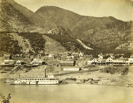
![Switchback. C&W Ry. [Columbia and Western Railway], Trail Creek Gulch, Trail, B.C.](/uploads/r/null/6/f/6f5cb65311ddcfc28adee9553f7186cb8e106d980ac633f0b1934a95a5faab46/d8fa0d41-c9c9-4436-8af6-23fa7c6667a0-A31879_142.jpg)
Switchback. C&W Ry. [Columbia and Western Railway], Trail Creek Gulch, Trail, B.C.
Part of Major Matthews collection
Sites and buildings identified: 1. Tadanac Smelter, 2. C.P.R. Station, 3. Trail, B.C., 4. C.P.R. Railway track, 5. The Gulch, 6. Road to Rossland.
![[View of Nelson]](/uploads/r/null/2/1/2168958d3457cb3ca712fef4e44c8ce4055891c41a954007b0750707b5dc12d3/3be10139-bcea-4555-bfdc-f6f275d78b21-A33432_142.jpg)
Part of Major Matthews collection
![[Panoramic view of] Dawson City Y.T. [and surrounding area during the gold rush]](/uploads/r/null/5/0/506e42684abd11564a15b6ed320519f1fdfe76b93282f62a101c43cb73368b4c/aef0d3ce-b0eb-45e2-8d0a-f639840ce71b-A64736_142.jpg)
[Panoramic view of] Dawson City Y.T. [and surrounding area during the gold rush]
Part of Major Matthews collection

View of Dawson City during the Klondike Gold Rush
Part of Major Matthews collection
![[View of Lillooet]](/uploads/r/null/d/7/d7599a4ef2952182c63a7487211cd218874a1992472bf88049d0f3c475709c1c/d1331256-b8fe-46ae-9972-a0bca9ae5153-A33609_142.jpg)
Part of Major Matthews collection
Photograph shows the first ranch in the area built by Richard Hoey
![[Bird's eye view of Rossland from Red Mountain]](/uploads/r/null/3/8/389da25b32593cf2601686eeeff4ab7710d997c31a5e9698fb3175703b35a1bc/c3819f29-a513-4892-8d7b-699b609a404e-A31878_142.jpg)
[Bird's eye view of Rossland from Red Mountain]
Part of Major Matthews collection
Sites and buildings identified: 1. Nickle Plate Mine, 2. Nickle Plate Flats, 3. Miner's Union Hall, 4. Upper Sourdough Alley, 5. Columbia Alley, 6. Allan Hotel, 7. Howard Hotel.

City looking east down Water Street
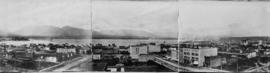
![[View of Whatcom (Bellingham)]](/uploads/r/null/1/d/1d0b1ddbccb58e63531e08c977775fb74519a32b85f14a1c4ade3d3df4c2a7a6/fad20b24-5065-4017-be11-92fcc1cc6281-A33313_142.jpg)
[View of Whatcom (Bellingham)]
Part of Major Matthews collection
Panoramic view
![[View of Whatcom (Bellingham)]](/uploads/r/null/0/4/04cd681dedd30f1d9e58d5ee0d3b7c661cdf0885c3827b1e5a8cfb217f108de8/e598c73d-58bf-4700-9c7a-e7aefe419f4f-A33312_142.jpg)
[View of Whatcom (Bellingham)]
Part of Major Matthews collection
Panoramic view
![[View of] Vancouver, B.C. from Stanley Park](/uploads/r/null/4/7/477ef12d66d2fd121cae13b24ea2e6c76317162749e92e599649f19477a14c18/ce07ea50-2e99-4c31-9e0e-d2f57f2b520c-A19512_142.jpg)
[View of] Vancouver, B.C. from Stanley Park
Part of Richard H. Trueman fonds
![[View of Whatcom (Bellingham)]](/uploads/r/null/d/3/d3500799c36b679cba68aa22e7dcc3cfa855ffc645b4ca3ba94b0a95c67f1119/78c9ea15-9046-47b3-b330-e27d22a62426-A33314_142.jpg)
[View of Whatcom (Bellingham)]
Part of Major Matthews collection
Panoramic view