
A. Kam on original first tee at Jericho Golf Course
- AM59-F03-: CVA 255-07
- Item
- 1908
Part of Jericho Country Club fonds
168 results with digital objects Show results with digital objects
A. Kam on original first tee at Jericho Golf Course
Part of Jericho Country Club fonds

A. Kam, club professional, on fourth tee
Part of Jericho Country Club fonds
![[A miniature golf course at the corner of Cardero Street and Georgia Street]](/uploads/r/null/8/8/88c09b61185ffb5d86a519d1e43df57d72e11ae07333c27464bd9b5577b8655c/84c1a393-5935-41fa-ab3b-be8075ede568-A36594_142.jpg)
[A miniature golf course at the corner of Cardero Street and Georgia Street]
Part of Major Matthews collection
![[A sand trap on Smithers golf course]](/uploads/r/null/5/d/5d713cd2322cace3e03de24e512010c4e5922b19064be901c509f4dff08d9ba4/0a7e6c78-a182-44ec-bc32-cca2f8ae44c1-A33472_142.jpg)
[A sand trap on Smithers golf course]
Part of Major Matthews collection
![[Aerial view from helicopter] - Shaughnessy Golf Club House](/uploads/r/null/5/d/5/5d5d8792969484ccece23357dbd8823275df30c087900509f9ad9548c867dd0d/09e33ad9-ff16-4e4b-9552-5a181fd0d2dc-CVA160-23_142.jpg)
[Aerial view from helicopter] - Shaughnessy Golf Club House
Part of William Orson Banfield fonds
![[Aerial view of Burrard Inlet, Hastings-Sunrise, Burnaby and the District of North Vancouver]](/uploads/r/null/d/f/df7e11c97173ce0473c454f0a01569b641972f6efdc12bf192edbc42119542d6/6d72f89b-9b55-48c4-bef6-04eb2137f1d3-A66600_142.jpg)
[Aerial view of Burrard Inlet, Hastings-Sunrise, Burnaby and the District of North Vancouver]
Part of Major Matthews collection
Photograph shows Exhibition Park and P.N.E. Golf Course, Second Narrows Bridge, New Brighton Park, Callister Park, Burrard Inlet, Lynn Creek, Lynn Park, Seymour Creek, Vancouver Harbour Commissioners Railway, Inspected Shingles Ltd., Cascade Rock and Gravel Co. Ltd., Canadian Shingle Co. Ltd. (Capilano Timber Co. Ltd.), Alberta Pool Elevator, Columbia Grain Elevator Co. Ltd., Canadian Pacific Railway, Girls Industrial School and Old Peoples Home sites.
![[Aerial view of Vancouver]](/uploads/r/null/b/9/b973b9a4143a5316b02e728c35d99e383f27a3db21d8e20aa7bbb459780243bc/3ff38b56-6b36-4c17-bce1-329c97459d29-A66598_142.jpg)
Part of Major Matthews collection
Photograph shows Kitsilano, Kits Point, Kitsilano Beach, R.C.A.F. Equipment Depot, Kitsilano Pool, Burrard Bridge, C.P.R. Kitsilano Trestle, Granville Island, Granville Bridge, Cambie Bridge, False Creek, C.P.R. False Creek Yards, West End, Yaletown, Arbutus Ridge, Shaughnessy, South Cambie, Fairview, Mount Pleasant, Little Mountain Reservoir, Connaught Park, Quilchena Golf Course, Douglas Park, Shaughnessy Heights Golf Course, Queen Elizabeth Park, Royal Canadian Mounted Police Barracks, Shaughnessy Military Hospital, Hillcrest Park, Robertson & Hacket Sawmill, City Yard, West Coast Ship Builders and Athletic Park.
![[Aerial view of West Point Grey, Kitsilano, Dunbar - Southlands and University Endowment Lands]](/uploads/r/null/0/8/089d213e9a81ca689130a244122a86972e068c9b01ab994922a88072ac881121/1ed71859-c157-4686-82db-e3483cd4b877-A66599_142.jpg)
[Aerial view of West Point Grey, Kitsilano, Dunbar - Southlands and University Endowment Lands]
Part of Major Matthews collection
Photograph shows the south Slope of English Bay, Spanish Banks, Locarno Beach Park, Jericho Beach, R.C.A.F. Jericho Air Station, Kitsilano pool, Connaught Park and Kitsilano Beach Park, Caldecott Park, Quilchena Golf Course, School for Deaf and Blind and Quesnel Park.
Part of Major Matthews collection
Oblique view showing the R.C.A.F. Jericho Air Station, the Jericho Golf Course, Locarno Beach, a boathouse, the Canadian Life Saving Association building and the houses at the foot of Imperial (Discovery) Street
Part of Major Matthews collection
Photograph shows an oblique view of R.C.A.F. Jericho Air Station at Locarno Beach and the Jericho golf course
Part of Major Matthews collection
Photograph shows an oblique view of R.C.A.F. Jericho Air Station at Locarno Beach, Jericho golf course and Imperial (Discovery) Street
![Beach Grove [golf course]](/uploads/r/null/0/a/0abeb4ea378ab7aff1584fab409f1efe11999babc6f266ee8de217396bb4496d/2dfb0a4a-8a3a-4072-9553-c73298675fec-A17987_142.jpg)
Part of Stuart Thomson fonds
![Beach Grove [golf course]](/uploads/r/null/3/d/3d0e30011617b863e5bdd5fc64ed2670fb982485a91bb544650d7afcb6239da2/9175cf38-a5c6-4bf5-9549-42015a3e5f0f-A17990_142.jpg)
Part of Stuart Thomson fonds
Part of City of Vancouver Archives sound recording and moving image collection
Item is a promotional film for the British Properties Limited, Capilano Estates containing title cards. The film shows the properties including houses, the golf course, the tool house, the club house and surrounding landscape. The film also shows the clearing of land by British Properties.


Part of City of Vancouver Archives technical and cartographic drawing collection
Map is a City Engineering Department base map of Vancouver, showing city blocks and Canadian Pacific, Canadian National and Great Northern Railway lines. Parks, golf courses, hospitals, schools, theatres and other structures are identified. "Metric Vancouver" and "Guide Map 15" appear in the bottom right corner of the map.

Part of City of Vancouver Archives technical and cartographic drawing collection
Map is a City Engineering Department base map of Vancouver, showing city blocks and Canadian Pacific, Canadian National and Great Northern Railway lines. Parks, golf courses, hospitals, schools, theatres and other structures are identified. "Guide Map 15" appears in the bottom right corner of the map.
![City of Vancouver [park sites June/80]](/uploads/r/null/9/4/9484add7c4684ea3838e4d00ee8add3ecf85d78d5aa8fe2780cae273e59556a5/bd2464d8-2aa9-4501-aba6-8b3f7d130a42-MAP1032_142.jpg)
City of Vancouver [park sites June/80]
Part of City of Vancouver Archives technical and cartographic drawing collection
Map is a City Engineering Department base map of Vancouver, with parks hand-coloured in green. Shows city blocks and Canadian Pacific, Canadian National and Great Northern Railway lines. Golf courses, hospitals, schools, theatres and other structures are identified. "Metric Vancouver" and "Guide Map 15" appear in the bottom right corner of the map.

City of Vancouver, British Columbia
Part of City of Vancouver Archives technical and cartographic drawing collection
Item is the western half of a map showing city blocks, transportation infrastructure, recreational facilities, hospitals, schools, theatres and other structures are identified. MAP 1036 is the eastern half of this map.
Vancouver (B.C.). Engineering Services

City of Vancouver, British Columbia
Part of City of Vancouver Archives technical and cartographic drawing collection
Item is the eastern half of a map showing city blocks, transportation infrastructure, recreational facilities, hospitals, schools, theatres and other structures are identified. MAP 1036b is the western half of this map.
Vancouver (B.C.). Engineering Services

City of Vancouver, British Columbia : co-ordinate street index map 12
Part of City of Vancouver Archives technical and cartographic drawing collection
Map is City Engineering Department base map 149 of the City of Vancouver, showing city blocks, streets and railway lines, as well as the area code co-ordinates assigned by the department. Golf courses, hospitals, schools, theatres and other structures are also identified.

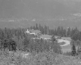
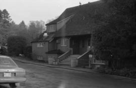
Club House, Burquitlam Golf Club
Part of William Orson Banfield fonds
![Fraserview Golf Club Clubhouse [7800 Vivian Drive]](/uploads/r/null/9/9/8/998fcd071c362c3261ed93675e5173c54074f058f98e00bb97d70a69ce804903/4822f2d9-8a83-452d-af8d-4f9486365846-CVA786-102_142.jpg)
Fraserview Golf Club Clubhouse [7800 Vivian Drive]
Part of City of Vancouver fonds

Part of City of Vancouver fonds

Fraserview Golf Course clubhouse [7800 Vivian Drive] - alterations and additions
File consists of architectural drawings showing designs for an extensive renovation and addition to the Fraserview Golf Club clubhouse. Drawings are location plan, site plan, foundation plan, floor plans, elevations, details, and electrical floor plans.
Vancouver Park Board
Fraserview Golf Course clubhouse [7800 Vivian Drive] - alterations and additions
File consists of architectural drawings depicting renovations to the clubhouse at the Fraserview Golf Course. The drawings depict elevations, floor plans, and details. Seven drawings are architectural design drawings by Percy C. Underwood; two of the drawings are electrical floor plans by R. Lennox Mackenzie.
Fraserview Golf Course, Field House
Part of City of Vancouver fonds

Fraserview Golf Course, Field House
Part of City of Vancouver fonds

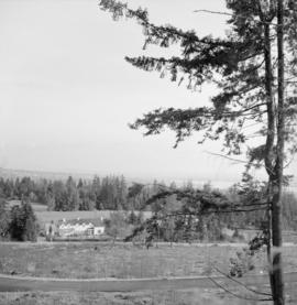
General view of Burquitlam Golf Links
Part of William Orson Banfield fonds
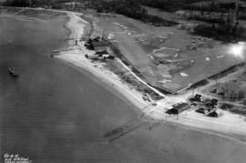
![[Gleneagles Golf Course]](/uploads/r/null/d/4/d4d0e1fc68956df6eb61f767b03682c6bac7a324c42e60874f1d8e798ed15a45/ce4075ce-a8a5-413f-8374-b5cc0a6dd604-A09910_142.jpg)
Part of Major Matthews collection
Photograph shows area formerly part of Larson's Ranch.
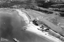
![[Gleneagles Golf Course]](/uploads/r/null/1/4/14100a99e68e215d338cc12150f205f07a2cad5868207eabf19489a1651d3bc9/ca2ec0e2-b6a9-42d7-9618-fba456865755-A09909_142.jpg)
Part of Major Matthews collection
Photograph shows area, formerly part of Larson's Ranch.
![[Gleneagles Golf Course]](/uploads/r/null/1/2/12ebefdb7f5bd57b61da8b13d47ca1da9def9b8f25612b08899e400270f33953/d6a75ed1-ebd5-4f7e-bd3d-47cf674385ed-A09912_142.jpg)
Part of Major Matthews collection
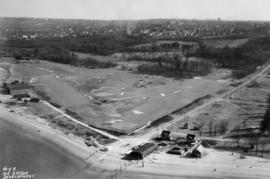
![[Gleneagles Golf Course]](/uploads/r/null/8/0/80a93a183abeefe836fb487a95e23a7d11e83e6d9916ec202730c979832e13f9/278a3065-9bb9-450e-ba09-2c2fc0e42828-A09908_142.jpg)
Part of Major Matthews collection
Photograph shows area, formerly part of Larson's Ranch
![[Gleneagles Golf Course]](/uploads/r/null/d/a/da94714f5ae7f48f7d13d24b06946ced51a68001443a175ff04140df917e189c/2d245cd1-e82b-40c1-b187-6ae62a6e3249-A09911_142.jpg)
Part of Major Matthews collection
Photograph shows area, formerly part of Larson's Ranch.
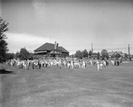
Golf - B.C. Amateur Championships
Part of Stuart Thomson fonds
Negative envelope notes that the championship is on the Quilchena Golf Course.


Part of William Orson Banfield fonds
Part of Stuart Thomson fonds

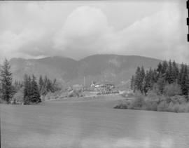
Golfers on the Capilano Golf Course
Part of Karl Haspel fonds

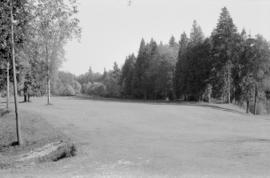
Historical : original appearance, Shaughnessy golf course

Historical : original site, Shaughnessy Golf Course
Historical : Shaughnessy golf course

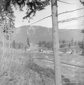
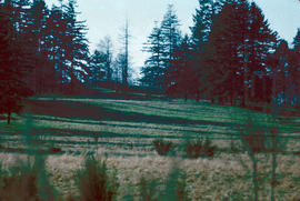
Hollyburn Golf Course, West Vancouver
Part of Major Matthews collection
Photograph shows the clearing for a potential golf course northeast of Marine Drive (Keith Road) and Seventeenth Street (Lawson Avenue)

Part of William Orson Banfield fonds