
Old Beaver dam in Mount Pleasant, with girl by stream
- AM1616-S1-: CVA 136-529
- Item
- Mar. 1940
Part of Pacific Press fonds
Old Beaver dam in Mount Pleasant, with girl by stream
Part of Pacific Press fonds
![[Three views of completed Coquitlam Dam]](/uploads/r/null/d/3/d3ceef2c5df82785038911ae627f004b66ce0d6dd6a650fb09b95305d0d03cbb/439a8aec-a8c4-41dd-ad0d-da7b600e775e-A08641_142.jpg)
[Three views of completed Coquitlam Dam]
Part of Major Matthews collection
Photograph is a copy of three photograph prints, showing: view along centre line of dam, showing water flowing over spillway in the foreground and bridge and reservoir to the right; view from lake side towards spillway, showing spillway bridge and gatehouse; and view of downstream side of dam from west bank, showing spillway through rock cup on the right and the borrow pit in the background. Negative was created to produce lantern slides of the three images.
![[Small dam constructed of boards and rocks]](/uploads/r/null/9/9/99b7aa28679d57b3984f34e0e1270513313f88e18da880f2e4517327f02322dd/502f1cc4-8dd1-438f-9d24-253002ee9eb1-A04790_142.jpg)
[Small dam constructed of boards and rocks]
Part of Major Matthews collection
![[Partially contructed Jordan River Power Plant, showing north end of Amburson type concrete dam]](/uploads/r/null/0/b/0b170c3585223ff840df36244b96de6f68e5ce57b3df938bf04acdabf61d31b0/6776c975-b550-4fd7-a6aa-899413ffa7fa-A08207_142.jpg)
[Partially contructed Jordan River Power Plant, showing north end of Amburson type concrete dam]
Part of Major Matthews collection
![[Pipes and rocks in partially excavated area of Coquitlam Dam construction site]](/uploads/r/null/7/a/7acc63641a0130762d419b2b4a6e2ee1ce87db3acf4c0b35d85cc716bce579d3/5465e8ad-442a-4200-aca0-44947fa4b38e-A08399_142.jpg)
[Pipes and rocks in partially excavated area of Coquitlam Dam construction site]
Part of Major Matthews collection
![[View of the first Capilano Creek dam under construction]](/uploads/r/null/b/e/bedbcf103b548bda85cf6901c9c4c1beea66a92ec3a205711b581ffc2f355de8/1005a023-9a5f-47be-8507-6cbe186c37a4-A25790_142.jpg)
[View of the first Capilano Creek dam under construction]
Part of Major Matthews collection

City waterworks dam, Vancouver, B.C.
Part of Major Matthews collection

Part of Major Matthews collection
Photograph negative is a copy of a cross section diagram of the dam, showing: rock fill in upstream and downstream toes; location of original dam buried in new structure; and the equivalent cross section of a concrete dam. Negative was created in order to produce a lantern slide of the image.
![[Various scenes regarding the construction of the Coquitlam Dam]](/uploads/r/null/7/9/797df543b86cd1f35bd5c78c6ca9d80fe224d230d981d9b2a0b4c0b04cc4a649/83f15ffd-043f-42c5-9767-c330a8686cbd-A08288_142.jpg)
[Various scenes regarding the construction of the Coquitlam Dam]
Part of Major Matthews collection
Photograph negative is a copy of five photograph prints, showing: water cresting over the top of the Coquitlam Dam; the clearing of the Coquitlam Dam site with a donkey engine; the roots of a large tree cleared off the Coquitlam Dam site; bridge over Coquitlam Dam; and two men sawing tree stump at Coquitlam Dam site. Negative was created to produce lantern slides of the five images.
![[View of Coquitlam Lake and Coquitlam Dam construction camp]](/uploads/r/null/6/4/64e606b65c399c06387e168ad6b94918ed882195c7d1542ea6be6d826cf213d7/33d7eb7a-d66e-4030-b056-d7bfe7234649-A08625_142.jpg)
[View of Coquitlam Lake and Coquitlam Dam construction camp]
Part of Major Matthews collection
![[The Cleveland dam during construction]](/uploads/r/null/5/c/5c69f304d5d2e6a3cf823464a2725ca42fbb5b8662fc309514aa6374bf13fd1c/cd53c6e5-06af-47cb-a7a0-bc6ccb7b195c-A33596_142.jpg)
[The Cleveland dam during construction]
Part of Major Matthews collection
![[The Cleveland Dam under construction]](/uploads/r/null/9/f/9fb7541557f4d9d32a3711f572fd6f27d3dd4b293b9dbbccb1166b12c617e6e3/3d04598b-f58c-40e3-b09d-7b0365dffa60-A33590_142.jpg)
[The Cleveland Dam under construction]
Part of Major Matthews collection
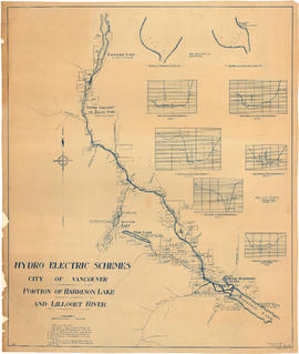
Portion of Harrison Lake and Lillooet River
Part of City of Vancouver fonds
Item is a map sheet survey data from Lilloet Lake in the north to Harrison Lake in the south. The main map show potential dam sites, water levels, bridges and wagon roads. Significant bodies of water included on the map are Harrison Lake, Little Harrison Lake, Glacier Lake, Fire Lake, Lilloet lake, Little Lillooet or Tenas Lake, and Lillooet River. Also shown are Billy Goat Creek, 25 Mile Creek, Rogers Creek, Gowan Creek, Glacier Creek, Spriny Creek, Tipella Creek, Douglas Creek and 6 1/2 Mile Creek. The sheet includes two nautical charts showing depth soundings at the south end of Lillooet Lake and the south end of Tenas Lake. The six sections show depth measured along points on the Lillooet River.

Looking at west side of Upper Capilano River
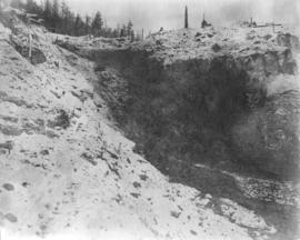
Photograph shows excavated site, with machinery and cables.
![[Men sluicing materials in borrow pit of Coquitlam Dam]](/uploads/r/null/8/7/87c4a72df20a369713dafef523ff30543c2f8ce2d4a60b73cbed1f4150fba08a/9042673d-ee12-4d55-9081-5c3a46998f3d-A08414_142.jpg)
[Men sluicing materials in borrow pit of Coquitlam Dam]
Part of Major Matthews collection
![[Men standing in partially excavated area of Coquitlam Dam construction site]](/uploads/r/null/c/4/c45e239977b9ef018f29b0bc2e7c5834b1193aef0fb9e25baf5f47b1f4e70094/14ca880a-f344-4b35-a8c1-840d470a1636-A08398_142.jpg)
[Men standing in partially excavated area of Coquitlam Dam construction site]
Part of Major Matthews collection
![[Men working on partially constructed dam]](/uploads/r/null/1/6/16e8984721f033f2b77766596b2a5d9163999935c5cdab6a6cadbe737404bd20/0993bd96-6edf-40d4-b042-6deb6de9dc7d-A04830_142.jpg)
[Men working on partially constructed dam]
Part of Major Matthews collection
![[Logs almost filling the river above the Cascade Light and Power Company dam]](/uploads/r/null/9/d/9de27a54a55b9e5b0a5061e843027c345415c5fb7fff387c376e11b803ea5345/69efb1c6-4c3c-4cfc-977a-bfe13cdc0067-A33320_142.jpg)
[Logs almost filling the river above the Cascade Light and Power Company dam]
Part of Major Matthews collection
![[Partially constructed Coquitlam Dam, looking east at edge of tree covered hillside]](/uploads/r/null/d/2/d25e9f0946b91c5196748e2803dfb1258451d97a2cbbfac5a0c597feb4afafd7/043df3c1-856c-46d0-bb24-3c7c3763b400-A08173_142.jpg)
[Partially constructed Coquitlam Dam, looking east at edge of tree covered hillside]
Part of Major Matthews collection
![[Partially constructed Coquitlam Dam, showing dam area and construction camp]](/uploads/r/null/9/9/99917fc064a831c320789979e28556ffd89b658a202746cfbe2675560bef65ff/a5fdb4c5-5f01-411e-8c31-a3ce2f51495c-A08415_142.jpg)
[Partially constructed Coquitlam Dam, showing dam area and construction camp]
Part of Major Matthews collection
![[Partially constructed Coquitlam Dam, showing trestle supported flume and hydraulic monitors]](/uploads/r/null/2/7/279816d1d9b1213f33d4efc3c8b247080894fcd9416cc3e0c74b7182ba3474a7/c007fe22-50ab-435e-97e0-b81e58ed5df2-A08643_142.jpg)
[Partially constructed Coquitlam Dam, showing trestle supported flume and hydraulic monitors]
Part of Major Matthews collection
![[Partially constructed Coquitlam Dam, showing trestle supported flume]](/uploads/r/null/e/e/eea2aaad046cdbdc9d9974557a57687887f715c8f18b11997fc82614f554c4d9/2bddfffa-e787-4903-8edd-c38dab33d07f-A08645_142.jpg)
[Partially constructed Coquitlam Dam, showing trestle supported flume]
Part of Major Matthews collection
![[Partially constructed Coquitlam Dam, showing upstream side of dam]](/uploads/r/null/f/f/ffea9158eb96d394ed5fca6d10a57e35757849cccc2b7d650cb69ffe52c26376/1e56a73e-6552-4f71-a03c-70dc21e52a1d-A08185_142.jpg)
[Partially constructed Coquitlam Dam, showing upstream side of dam]
Part of Major Matthews collection
![[Partially constructed Coquitlam Dam, showing upstream toe of dam]](/uploads/r/null/5/d/5d8be21eaef4e451d180e0951734a4204b7520be6223e3a19ed9bd02037f9880/6fc2e9c2-e54d-4ddc-8b33-3ad2cbef2606-A08181_142.jpg)
[Partially constructed Coquitlam Dam, showing upstream toe of dam]
Part of Major Matthews collection
![[Five views of Coquitlam Dam construction]](/uploads/r/null/0/e/0ec77062c2e24ed48d3cc4f23e6aa897346cd1466cbbd664f776d3021b5d71d4/e00ad370-7836-4dc7-8e51-baf1ea19522e-A08657_142.jpg)
[Five views of Coquitlam Dam construction]
Part of Major Matthews collection
Photograph negative is a copy of five photograph prints, showing: original construction camp; construction camp and surrounding area; first rapids of Schuyler Creek near dam site; sluicing done for proposed canal to sluice tunnel; and bridge across spillway of the original dam. Negative was created in order to produce lantern slides of the five images.

[Four views of Coquitlam Dam and Buntzen Lake Power Plant number two construction
Part of Major Matthews collection
Photograph negative is a copy of four photograph prints, showing: early excavation at Buntzen Lake power house site; view looking up Coquitlam Lake from east end of dam, showing cleared shores that will be submerged when water levels are raised; trestle work for Coquitlam Dam; and downstream view of original Coquitlam Dam, showing construction sawmill in the background. Negative was created in order to produce lantern slides of the four images.

Part of Major Matthews collection
Photograph negative is a copy of a plan for the dam, showing various measurements and notes.

View of settling pond taken from 1200.0 looking to 1400.0 on 24th June 1913
Part of Major Matthews collection
Photograph shows water below flumes of Coquitlam Dam.
![[Pipeline at Lake Buntzen (Beautiful)]](/uploads/r/null/4/0/408c6aea725b31557c08ab39bae1cda804c706631cbcc8a14c3eaeb4c4f6e154/e9beb161-32dd-4ecb-bd19-96e69f9b372d-A63011_142.jpg)
[Pipeline at Lake Buntzen (Beautiful)]
Part of Major Matthews collection
![[A dam under construction]](/uploads/r/null/e/b/eb7be7ba28c2f21880f49c782a527157ed260aa7a9fe40eb866187c4ab0971d2/b85994e0-be03-428e-985a-8678b807fdde-A23377_142.jpg)
Part of Major Matthews collection
![[A team of horses at Buntzen Lake Dam construction site]](/uploads/r/null/3/8/3886a7156f8e6c202f36fb6365ac2f28822970a63a32be82c7ec5b0dbef8a590/d82e971f-db37-452b-ad55-e68067073254-A23349_142.jpg)
[A team of horses at Buntzen Lake Dam construction site]
Part of Major Matthews collection
Photograph shows a construction engine in the background
![[An unidentified dam under construction]](/uploads/r/null/7/f/7f1a34d388940bf0c40e25b68575a67d797cf442e5526c55ae91c2cc37e5d738/e7d16baa-6fa5-492e-8df3-04fd627cc8a2-A23369_142.jpg)
[An unidentified dam under construction]
Part of Major Matthews collection
![[Buntzen Lake Dam under construction]](/uploads/r/null/1/1/11ec44198540f001e068048fb6ac495404409b539b88ef19f1a99986dacc7980/6560de6d-c435-46b3-981c-68ad1ceae6bd-A23294_142.jpg)
[Buntzen Lake Dam under construction]
Part of Major Matthews collection
![[Buntzen Lake Dam under construction]](/uploads/r/null/7/6/769c52779cb2d872b607ecd63d17d05ebd4e4aaae8937d777532f6d313b2cdc6/b471d87c-25f5-49b4-be63-05b38c028d73-A23318_142.jpg)
[Buntzen Lake Dam under construction]
Part of Major Matthews collection
![[Buntzen Lake Dam under construction]](/uploads/r/null/3/8/382da3c49a83aafc8b13b93e48b3741b11a4bd1d805598d81b5bf75846f90a97/bad53ec7-8cab-4fa7-9e77-13212b9d9d2e-A23324_142.jpg)
[Buntzen Lake Dam under construction]
Part of Major Matthews collection
![[Buntzen Lake Dam under construction]](/uploads/r/null/2/f/2f707d514d0fa55690ad6f00370ebb11dc3c68380d01de99b9529ec303299267/13d4c836-9b65-41d9-bfc8-8abc897ce5f3-A23334_142.jpg)
[Buntzen Lake Dam under construction]
Part of Major Matthews collection
![[Dam construction at Buntzen Lake]](/uploads/r/null/2/c/2cd670e1d9746893514e872259a682989ae6d260d8f5016c64c3f162eb0ba8fd/3ccf349d-631c-45a3-9aae-0d00a6dd40ac-A23292_142.jpg)
[Dam construction at Buntzen Lake]
Part of Major Matthews collection
![[Electricity conductors at Buntzen Lake Dam]](/uploads/r/null/a/d/ad2ba0642c04626271b9599982126a69a75699440115567584dfe4d320082d31/e6591b79-166e-4c21-9839-0452ffe21218-A23335_142.jpg)
[Electricity conductors at Buntzen Lake Dam]
Part of Major Matthews collection

Part of Major Matthews collection
Photograph shows the construction camp
![Coquitlam Dam [showing] drag bucket entering tipple](/uploads/r/null/f/8/f850f11cb74a0ba9928d7feec874c0aed58cde3742b1bd77171a015c2e0c32d9/6e6521af-2fd7-46e8-b48b-22d6625fab5d-A32871_142.jpg)
Coquitlam Dam [showing] drag bucket entering tipple
Part of Major Matthews collection
![Coquitlam Dam [showing] entance channel to headworks](/uploads/r/null/2/6/269bd180de31411f8aac716bbdc09f28435837ac44e2cae3a8b77f28e7af2f0d/60bdc0b7-d25a-40ee-85da-235c4af83d1b-A32897_142.jpg)
Coquitlam Dam [showing] entance channel to headworks
Part of Major Matthews collection
![Coquitlam Dam [showing] hydraulic monitor sluicing material](/uploads/r/null/c/7/c74fe0b82afa58e1c075316409beda1420a944a1a4c50d4c586578194942299a/d81fb1c3-f3d8-4ac8-9e70-d6a7ff1f041d-A32914_142.jpg)
Coquitlam Dam [showing] hydraulic monitor sluicing material
Part of Major Matthews collection
![Coquitlam Dam [showing] view downstream from east bank over spillway](/uploads/r/null/8/e/8ed0843af1ad35cee72192f60ec7b36c45244c3acb4a23a26b223ff19e9e8cbe/56af211f-2b69-482f-a6be-cb6cfcf8735f-A32902_142.jpg)
Coquitlam Dam [showing] view downstream from east bank over spillway
Part of Major Matthews collection
Photograph shows the pumphouse for sluicing

Coquitlam Dam entrance channel cut looking towards headworks stake
Part of Major Matthews collection

Part of Major Matthews collection

Coquitlam Dam headworks site as suggested by Mr. Schuyler after ledge exposed by monitors
Part of Major Matthews collection
Coquitlam Dam headworks site as suggested by Mr. Schuyler after ledge exposed by monitors
Part of Major Matthews collection

Coquitlam Dam looking along the slope in the headworks entrance channel
Part of Major Matthews collection

Coquitlam Dam stratum overlying bedrock elevation 480
Part of Major Matthews collection
Photograph shows the north side of the exploration cut along Mr. Schuyler's proposed tunnel line

Coquitlam Dam view from headworks along the entrance channel
Part of Major Matthews collection