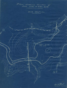
Plan showing locations of dam sites at Green Lake
- COV-S346-F01-: MAP 1143
- Item
- [1923?]
Part of City of Vancouver fonds
Plan showing locations of dam sites at Green Lake
Part of City of Vancouver fonds
![Longitudinal section along [centre line] of dam sites at north end of Green Lake](/uploads/r/null/7/4/a/74af74789da62d7da66c012dd18dd964e4e83151ac5f0b139a53843bce6ccfe6/974ff05f-0f29-4e65-b818-c663b1a236e1-MAP1142_142.jpg)
Longitudinal section along [centre line] of dam sites at north end of Green Lake
Part of City of Vancouver fonds
Item is a sheet depicting 2 profiles: one of dam no. 1 at railway crossing at 2247+763 and one of dam no. 2 at the head of the Green River (Green Lake).

Profile on possible dam sites across Soo River at 2+4340
Part of City of Vancouver fonds

Profile dam no. 2 Soo River at 4+4980
Part of City of Vancouver fonds

Part of City of Vancouver fonds
Item is a map sheet containing two profiles: one showing the increased reservoir height with a subsidiary dam built and the other a profile of the proposed subsidiary dam site.
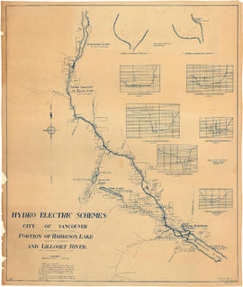
Portion of Harrison Lake and Lillooet River
Part of City of Vancouver fonds
Item is a map sheet survey data from Lilloet Lake in the north to Harrison Lake in the south. The main map show potential dam sites, water levels, bridges and wagon roads. Significant bodies of water included on the map are Harrison Lake, Little Harrison Lake, Glacier Lake, Fire Lake, Lilloet lake, Little Lillooet or Tenas Lake, and Lillooet River. Also shown are Billy Goat Creek, 25 Mile Creek, Rogers Creek, Gowan Creek, Glacier Creek, Spriny Creek, Tipella Creek, Douglas Creek and 6 1/2 Mile Creek. The sheet includes two nautical charts showing depth soundings at the south end of Lillooet Lake and the south end of Tenas Lake. The six sections show depth measured along points on the Lillooet River.
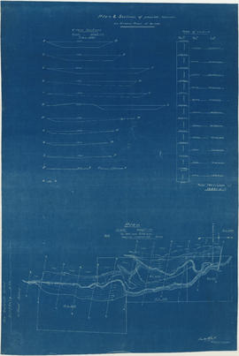
Plan & sections of possible reservoir on Green River
Part of City of Vancouver fonds
Item is a map sheet that depicts a portion of the Green River with a proposed dam site. Twelve cross-sections of the resultant reservoir are depicted, with estimated total cubit feet of water for each in an accompanying table.
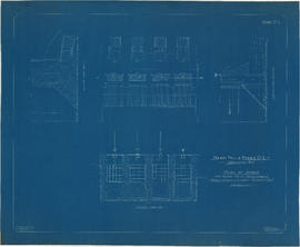
Plan of intake for Nairn Falls development. Green River. Lillooet District, B.C.
Part of City of Vancouver fonds
Item is an architectural drawing which depicts 1 elevation and 3 sections of the tunnel intake on the Green River.

Plan of dam for Nairn Falls development. Green River. Lillooet District, B.C.
Part of City of Vancouver fonds
Item is an architectural drawing sheet. The sheet includes a site plan, elevation and 2 sections of the proposed dam for the Nairn Falls site.
![Plan of fore bay [Nairn Falls hydro electric development]](/uploads/r/null/a/5/5/a55f94fc41cdf02e4a01434daeaf4b6c8715d61bd2a3842a95887e8c7f3371d0/29aba9ea-44a6-4453-9451-4896c8923762-MAP1099_142.jpg)
Plan of fore bay [Nairn Falls hydro electric development]
Part of City of Vancouver fonds
Item is a sheet that contains a map of the location of the dam fore bay, an elevation drawing of the spillway side of the fore bay, 1 section of the fore bay and 2 sections of the fore bay dam.
![General plan [of hydro-electric development on Green River]](/uploads/r/null/d/9/e/d9e4c58e28a2189f0c1819b9c491a0478fad0353e2100858ec1eb94c55b96eae/93fa8e5f-c3b7-4e51-802d-979b7bc07f6f-MAP1098_142.jpg)
General plan [of hydro-electric development on Green River]
Part of City of Vancouver fonds
Item is a sheet containing a map of the proposed development and an elevation of the site, showing the dam, tunnel and powerhouse.

Hydro electric survey City of Vancouver : Cheakamus River system from Squamish River to Green River
Part of City of Vancouver fonds
Item is a map which shows a proposed hydro electric development of the Cheakamus River system from the Squamish River to Green Lake. The map includes proposed tunnel routes, diversions, storage reservoirs, dams, power houses, canals, and pipelines. Also shown are areas of suggested future development and the Pacific Great Eastern railway line. Included in the area surveyed are Garibaldi Lake, Starvation Lake, Deadman's Lake, Daisy Lake, Stoney Lake, Cheakamus Lake, Alta Lake, Nita Lake, Alpha Lake, and Green Lake, as well as the Squamish River, Pilchuk River, Cheakamus River, Soo River, Green River, and various creeks. Map is hand coloured with pencil annotations concerning watersheds, land height and creeks not included on the original map design.

Hydro electric survey City of Vancouver : Cheakamus River system from Squamish River to Green River
Part of City of Vancouver fonds
Item is a map which shows a proposed hydro electric development of the Cheakamus River system from the Squamish River to Green Lake. The map includes proposed tunnel routes, diversions, storage reservoirs, dams, power houses, canals, and pipelines. Also shown are areas of suggested future development and the Pacific Great Eastern railway line. Included in the area surveyed are Garibaldi Lake, Starvation Lake, Deadman's Lake, Daisy Lake, Stoney Lake, Cheakamus Lake, Alta Lake, Nita Lake, Alpha Lake, and Green Lake, as well as the Squamish River, Pilchuk River, Cheakamus River, Soo River, Green River, and various creeks.
Part of City of Vancouver fonds
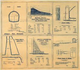
Item is an architectural drawing sheet with six drawings related to proposed hydro electric development on the Chilliwack River: Tunnel section; Spillway section-rock-filled timber crib dam at Chilliwack Lake; Tunnel intake; Tunnel outlet & surge tank; Diversion & storage dam; and Power house and tailrace. Each drawing includes cost and quantity estimates for construction materials.
![[A dam across a river]](/uploads/r/null/3/9/1/391879463139bc6b45335bd04000254f9ef028d6f563ef99e75b29d0e4f7876e/d70b7f2b-dcd3-4ff3-84fa-457b77d1f84c-CVA260-2056_142.jpg)
Part of James Crookall fonds

City waterworks dam, Vancouver, B.C.
Part of Major Matthews collection
![[Men with equipment on top of partially constructed dam]](/uploads/r/null/6/1/613d750b274089f3001bd6497f4a7d90f09b5a88eb4877c11da4df5ab89cc2a3/9cfb7a6d-469c-40d2-a751-58266e5e35b5-A04835_142.jpg)
[Men with equipment on top of partially constructed dam]
Part of Major Matthews collection
![[Men working on partially constructed dam]](/uploads/r/null/1/6/16e8984721f033f2b77766596b2a5d9163999935c5cdab6a6cadbe737404bd20/0993bd96-6edf-40d4-b042-6deb6de9dc7d-A04830_142.jpg)
[Men working on partially constructed dam]
Part of Major Matthews collection
![[Men constructing wooden dam in cleared area]](/uploads/r/null/b/c/bcbd437fd99f3bffd1cf8c0039fa0ce5d178cef214885ee33c97a348050de612/15418ac7-1d29-4d81-9427-1d680f315c88-A04797_142.jpg)
[Men constructing wooden dam in cleared area]
Part of Major Matthews collection
![[Wooden dam in cleared area, diverting water into two wooden chutes]](/uploads/r/null/8/d/8d3b0a05d710ba105a84db9af5115fbb8860293738e873475087091f4428a9b2/e86f6932-f11e-480c-a041-9b84b33f33f0-A04796_142.jpg)
[Wooden dam in cleared area, diverting water into two wooden chutes]
Part of Major Matthews collection
![[Small dam constructed of boards and rocks]](/uploads/r/null/9/9/99b7aa28679d57b3984f34e0e1270513313f88e18da880f2e4517327f02322dd/502f1cc4-8dd1-438f-9d24-253002ee9eb1-A04790_142.jpg)
[Small dam constructed of boards and rocks]
Part of Major Matthews collection
![[Aerial view of the Cleveland Dam and Capilano Lake]](/uploads/r/null/2/d/2dd436651b825b9f47ef30c7faef322e33a7a58fafcada712d5da71134736c7d/af2b6b11-8b8c-4e04-9855-a2c6380c8e6f-A33749_142.jpg)
[Aerial view of the Cleveland Dam and Capilano Lake]
Part of Major Matthews collection
Oblique view
![[Vancouver Water Works dam and buildings on Capilano Creek]](/uploads/r/null/e/4/e42d9372f9ce05363c449b264c7e55f99c8a3c6b6b000ce3089d856df9be64b2/b4263bca-eab6-432f-846d-1ce812f5486c-A33718_142.jpg)
[Vancouver Water Works dam and buildings on Capilano Creek]
Part of Major Matthews collection
![[The first water over the Cleveland Dam]](/uploads/r/null/9/1/91a7d527c3aad2ebd6f0641a537a13fc30e8bfa3b73d61456bfdcc0529051d47/31feda63-3acf-47af-ba1f-473986c4e0e5-A33663_142.jpg)
[The first water over the Cleveland Dam]
Part of Major Matthews collection
![[The Cleveland dam during construction]](/uploads/r/null/5/c/5c69f304d5d2e6a3cf823464a2725ca42fbb5b8662fc309514aa6374bf13fd1c/cd53c6e5-06af-47cb-a7a0-bc6ccb7b195c-A33596_142.jpg)
[The Cleveland dam during construction]
Part of Major Matthews collection
![[The Cleveland Dam during construction]](/uploads/r/null/e/7/e76da0de57f56895728f0940b302f9a503a86360786b389eed9555ed4abcc6ea/e4399080-cc70-48a1-a381-f3dd402f65b4-A33593_142.jpg)
[The Cleveland Dam during construction]
Part of Major Matthews collection
![[A tunnel under construction for the Cleveland Dam]](/uploads/r/null/7/e/7e98f5d0213832a932249dd19907390d9cd3d2b378ed0529ac2f184144e284c7/7aa63bf4-09ea-47ac-9474-60a15068823d-A33591_142.jpg)
[A tunnel under construction for the Cleveland Dam]
Part of Major Matthews collection
![[The Cleveland Dam under construction]](/uploads/r/null/9/f/9fb7541557f4d9d32a3711f572fd6f27d3dd4b293b9dbbccb1166b12c617e6e3/3d04598b-f58c-40e3-b09d-7b0365dffa60-A33590_142.jpg)
[The Cleveland Dam under construction]
Part of Major Matthews collection
![[The Cleveland Dam under construction]](/uploads/r/null/c/8/c851863e355848e4927e959621f1844547dbcb71fe0b8aed2869a7f3e40f7ab2/48829946-13f3-4531-99c2-d08503ad7b81-A33587_142.jpg)
[The Cleveland Dam under construction]
Part of Major Matthews collection
![[The Cleveland Dam under construction]](/uploads/r/null/9/5/953e65279417bd4e57d0fef850bfaefc1fc5f6180faeefc67c7ad29003611a7c/fc91cfd3-f863-4546-858e-1ebc0526a8b8-A33586_142.jpg)
[The Cleveland Dam under construction]
Part of Major Matthews collection
![[The caretaker's cottage and the Capilano Dam intake]](/uploads/r/null/e/9/e9fc9f6450a320f9d110d2c524376eb80c33973378eb284d56e36a543e405d42/2733b73e-c239-4ff4-b194-5446489bc706-A33532_142.jpg)
[The caretaker's cottage and the Capilano Dam intake]
Part of Major Matthews collection
![[Logs almost filling the river above the Cascade Light and Power Company dam]](/uploads/r/null/9/d/9de27a54a55b9e5b0a5061e843027c345415c5fb7fff387c376e11b803ea5345/69efb1c6-4c3c-4cfc-977a-bfe13cdc0067-A33320_142.jpg)
[Logs almost filling the river above the Cascade Light and Power Company dam]
Part of Major Matthews collection
![[Cascade Light and Power Company's dam]](/uploads/r/null/5/f/5f60beaecdb121071b52869f1291e89841192c314f5c776bf395ea7d5611cea4/1771cb4c-4d67-40b7-9454-8167386b8c07-A33319_142.jpg)
[Cascade Light and Power Company's dam]
Part of Major Matthews collection
![[Maintenance inside a hydro-electric dam]](/uploads/r/null/a/5/a5fc93b54fcebed765a1ccdd26e6b05585a262926abee550fc5dd69d2a165c4b/47e88d8d-43e4-46d1-bf16-5b3214295380-A33214_142.jpg)
[Maintenance inside a hydro-electric dam]
Part of Major Matthews collection
![[View of gates on hydro-electric dam]](/uploads/r/null/0/5/05c52b1d62aac994edd7cfc5e4431ec957ebf8e0155cca90f9ba971a484d9376/393ffb37-4bd3-4074-99f8-8c7b5814da6e-A33216_142.jpg)
[View of gates on hydro-electric dam]
Part of Major Matthews collection
![[Flood gate maintenance inside a hydro-electric dam]](/uploads/r/null/c/f/cfa3f6b3ffeb1076ed4a4b154c09fe33c9967fe5ca2d52215c6ec9931c906a72/59a54c69-0207-4fd3-a878-4bf98450c720-A33213_142.jpg)
[Flood gate maintenance inside a hydro-electric dam]
Part of Major Matthews collection
![[Electric generator building on dam]](/uploads/r/null/7/4/74929ff55856ffaffea66029b7a79ba26ed4aab35c265ab81b5f164988af3569/253ced17-e004-4168-8fb7-f701445488f6-A33212_142.jpg)
[Electric generator building on dam]
Part of Major Matthews collection
![[Part of hydro-electric dam with the flood gates closed]](/uploads/r/null/0/5/054a31bff500301a91fd842d8512c38c70d75eb53594e8e509b5a74ddb393b87/2a0778f1-cd81-4e69-a516-fd320d251e11-A33211_142.jpg)
[Part of hydro-electric dam with the flood gates closed]
Part of Major Matthews collection
![[Man inside hydro-electric dam]](/uploads/r/null/e/7/e7ed1101515b3623de31f60f9ce91584c9b37dcc1ede4002a4958c1c1b348272/19c024f9-2868-497d-9589-9bbb69af9360-A33210_142.jpg)
[Man inside hydro-electric dam]
Part of Major Matthews collection
![[A crane on an hydro-electric dam]](/uploads/r/null/5/c/5ca46641f61b314a660fe501dcab79cc3c08d423098788745bf7c6adae435eb3/d8d35afc-1c9a-4b62-b037-56cb9066dbfd-A33208_142.jpg)
[A crane on an hydro-electric dam]
Part of Major Matthews collection
![[A natural dam on the Kicking Horse River]](/uploads/r/null/6/c/6cfc974993b8b8a2f5a9bcb329e748e7188fc0e544357b53239badde8461e9a4/76fc7424-6440-4e32-b2fa-32aa3f937d77-A33090_142.jpg)
[A natural dam on the Kicking Horse River]
Part of Major Matthews collection
![[Aerial view of Cleveland Dam]](/uploads/r/null/7/6/76e433a06ca4446d457454da245c93b33735b7734edffb74927fc5b352ee5dd6/9c627964-b2fa-4eb4-9fdb-152ce6425ea4-A34094_142.jpg)
[Aerial view of Cleveland Dam]
Part of Major Matthews collection
Oblique view showing "The Lions"
![[Aerial view of Seymour Creek Dam]](/uploads/r/null/6/8/68188aefc4414456bd2dacd0cd9dfff2a6c2d96bb8400e47a69f24748909569a/44276fbd-2bce-4c02-a993-5d8e4085bd11-A34093_142.jpg)
[Aerial view of Seymour Creek Dam]
Part of Major Matthews collection
Oblique view
![[Various scenes regarding the construction of the Coquitlam Dam]](/uploads/r/null/5/5/550144e98ccfa3f77bbfbd5f79fc3d916187380dd58028ae9b322aa675fceb38/f2f28c94-ec1a-492f-b8be-de30ffca20d0-A08290_142.jpg)
[Various scenes regarding the construction of the Coquitlam Dam]
Part of Major Matthews collection
Photograph negative is a copy of four photograph prints, showing: exploration cut at centre line of dam; partially cleared dam site; two men sawing tree stump on dam site; and partially cleared dam site covered in snow. Negative was created to produce lantern slides of the four images.
![[Various scenes regarding the construction of the Coquitlam Dam]](/uploads/r/null/d/6/d6d45924e09a12f230a57f6f88978de0ecd8dbf271dd18034c79030292831924/5d63202a-40ef-4212-b867-4a2bea67ba02-A08289_142.jpg)
[Various scenes regarding the construction of the Coquitlam Dam]
Part of Major Matthews collection
Photograph negative is a copy of four photograph prints showing: view along centre of partially constructed dam, showing sluices; area around dam covered in ice and snow; excavated area on dam site; and water cresting over dam. Negative was created to produce lantern slides of the four images.
![[Various scenes regarding the construction of the Coquitlam Dam]](/uploads/r/null/7/9/797df543b86cd1f35bd5c78c6ca9d80fe224d230d981d9b2a0b4c0b04cc4a649/83f15ffd-043f-42c5-9767-c330a8686cbd-A08288_142.jpg)
[Various scenes regarding the construction of the Coquitlam Dam]
Part of Major Matthews collection
Photograph negative is a copy of five photograph prints, showing: water cresting over the top of the Coquitlam Dam; the clearing of the Coquitlam Dam site with a donkey engine; the roots of a large tree cleared off the Coquitlam Dam site; bridge over Coquitlam Dam; and two men sawing tree stump at Coquitlam Dam site. Negative was created to produce lantern slides of the five images.
![[Various scenes regarding the activities of the B.C. Electric Railway Company]](/uploads/r/null/0/4/0467efa94464a02c16e7e38b6205a4b0778adf1514ce8924e4ac79c3a7001f04/1ad6b443-1dee-4db8-9265-74dc574fcf64-A08284_142.jpg)
[Various scenes regarding the activities of the B.C. Electric Railway Company]
Part of Major Matthews collection
Photograph negative is a copy of four photograph prints, showing: people assembled on porch for Director's visit to construction site; partially constructed Coquitlam Dam; water flowing through temporary gates of dam; and construction site for Coquitlam Dam. Negative was created to produce lantern slides of the four images.
Part of Major Matthews collection

Part of Major Matthews collection
![[Partially contructed Jordan River Power Plant, showing north end of Amburson type concrete dam]](/uploads/r/null/0/b/0b170c3585223ff840df36244b96de6f68e5ce57b3df938bf04acdabf61d31b0/6776c975-b550-4fd7-a6aa-899413ffa7fa-A08207_142.jpg)
[Partially contructed Jordan River Power Plant, showing north end of Amburson type concrete dam]
Part of Major Matthews collection