![[Vancouver General Hospital]](/uploads/r/null/8/4/6/8463c4a8ceffca3772091b3ca67e14bd929fcba16d422ae5a3a9fba896a2096c/403095eb-1372-41af-928c-8e67b782feb3-CVA1342-6_142.jpg)
[Vancouver General Hospital]
![[Vancouver from Mount Pleasant]](/uploads/r/null/2/3/23e8640b2925830ea0753e97d4919c0e7e1e7fa630d8293896a6f5ffbf243cbb/faf31b60-1ab8-4eaf-bca7-34193b1b7d99-A20087_142.jpg)
[Vancouver from Mount Pleasant]
![[Stanley Park Causeway featuring entrance to the park]](/uploads/r/null/a/8/a8794968eb17d93f1c49b0e1da0ebf0188082508e3f007c23c8eba8a487b4acc/b6dcb6ff-4243-4d5e-90e5-6cae90ea24ce-A71214_142.jpg)
[Stanley Park Causeway featuring entrance to the park]
![[Kitsilano Point from the balcony of 1982 Ogden Street]](/uploads/r/null/9/9/99fde0a90886076f65828dd841c926d91ba635f8feeb587cf4127f77d4c0ff2a/dffdd345-86f3-4baa-bd78-e72dba1c56c6-A71779_142.jpg)
[Kitsilano Point from the balcony of 1982 Ogden Street]
![[Kitsilano Point from the balcony of 1982 Ogden Street]](/uploads/r/null/2/e/2ef4ec9f7c6ef7034a5bc5cb5e8fb36a1c892fe1a31c0724f1ea05efd779ee5b/e1f9393e-d4f8-4a2d-9792-f45b2ab33449-A71780_142.jpg)
[Kitsilano Point from the balcony of 1982 Ogden Street]
![King George Service [view of memorial procession along causeway into Stanley Park]](/uploads/r/null/5/5/5511af8b190f08ec9ca80e6c2654d64d2a96c9d2991ce13167ed7e96da121162/f7e609c6-7614-416b-85bc-1f50fe1563d9-A21710_142.jpg)
King George Service [view of memorial procession along causeway into Stanley Park]
![King George Funeral Service [view of memorial procession along causeway into Stanley Park]](/uploads/r/null/4/6/462fb8bda4e984a828525065f3d0f747798caa0cc783172624230a8beef9cd0b/2e055ab1-87f1-4850-aa34-1f3aea7b2ec0-A21711_142.jpg)
King George Funeral Service [view of memorial procession along causeway into Stanley Park]
![Grant St. and Com[mercial] Drive [residence of Professor Odlum]](/uploads/r/null/c/9/c99433fac4f172c2764f08319c035f0585e1f3012fba12927db21e442de29038/d4bc267c-55d0-4de3-8f67-7809dbf8e47d-A21852_142.jpg)
Grant St. and Com[mercial] Drive [residence of Professor Odlum]
![1st Ave. and Comm[ercial] DR.](/uploads/r/null/c/f/cf81dde0b1c32fd8fafa65d15d4f276696b81dd610f5971e108ac38cb90ea578/ec6755a0-9379-4a0f-aed0-de24c04a5341-A21925_142.jpg)
1st Ave. and Comm[ercial] DR.
![Shallcross Nasmyth Adjusting Co. - Auto accident on Pacific Highway [Location of accident]](/uploads/r/null/a/e/b/aeb54908efd2d894067e64d05d939279e14e99e7c5e0c49f17df04f820dcc3b0/a2d55ca5-a2d1-4c5e-8698-725a12aef54e-CVA99-7732_142.jpg)
Shallcross Nasmyth Adjusting Co. - Auto accident on Pacific Highway [Location of accident]

Dunbar St. at 29th Ave. looking south

Map of Vancouver, New Westminster, Steveston and the Lower Mainland District
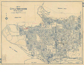
Map of City of Vancouver, British Columbia
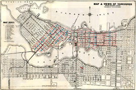
Map and views of Vancouver, British Columbia, Canada

Stuart's pocket map of Vancouver, B.C.

Vancouver, British Columbia

Town-site of Hastings

Plan 3

Georgia Street, Winter 1915
![Kingsway and Tyne [Street] south side city outgoing](/uploads/r/null/0/b/0bf39b6b460082650afaf68e6054c37bc2ecbb77845e617d1ab767cf73c28d18/a69f846a-682e-426e-b004-1f9fe36aca0f-A20221_142.jpg)
Kingsway and Tyne [Street] south side city outgoing
![Kingsway and Bursill [Street] north side city incoming](/uploads/r/null/b/d/bdcf72b11f535a06e0ee84c2d8540d7754a4963026dca120edc3e9f4bc68f1de/019ef39e-d4b6-4f20-9660-93cfa5d1da9e-A20226_142.jpg)
Kingsway and Bursill [Street] north side city incoming
![Kingsway and Moss [Street] north side city incoming](/uploads/r/null/f/2/f201ec05bf4c22fb97b352ee4aab23526ad54e074096c6f40c62ca9fd335f993/77a1850c-35d0-43d6-917f-03551b29d42f-A20227_142.jpg)
Kingsway and Moss [Street] north side city incoming
![Kingsway and Duchess [Street] north side city incoming](/uploads/r/null/1/0/103ab11582119b58b8d6352df287f486dedb4d7843ae8484f1fd5a15a44fb2a6/924739ea-10dc-451b-84d9-e199e22da0ad-A20228_142.jpg)
Kingsway and Duchess [Street] north side city incoming
![Granville [Street] and Marine Drive southwest city](/uploads/r/null/3/b/3bc9390dada095d5d010393e87135ac4a082c191786bfd9e0d7be4d5e42e39b2/d7179077-357d-4d8b-a8b6-9539f8f50ddf-A20275_142.jpg)
Granville [Street] and Marine Drive southwest city

The Drive, English Bay
![[Government Road (East 29th Avenue)]](/uploads/r/null/d/4/d43f5b4a03b4bc3c57758966d50da45ab6d3956251edc48b278556d92f4668be/eb3c8f79-550f-4067-bd1d-1b41d61cf872-A62165_142.jpg)
[Government Road (East 29th Avenue)]
![Court House from Cambie [Street] and Pender [Street]](/uploads/r/null/2/0/205819300d7886d98747ddca22d5c82797c537e0bf9050a8a5576b9e5e2c82d2/e2692891-4621-47a3-a166-dd95c34597f4-A49524_142.jpg)
Court House from Cambie [Street] and Pender [Street]

Approach to C.P.R. Wharves, Vancouver

[View of Stanley Park causeway showing Lost Lagoon and the Vancouver Rowing Club building on Coal Harbour]
![Temporary plank road, Main St. to [Canadian Northern Railway] freight shed, Vancouver](/uploads/r/null/b/d/bdee37be5613c8815750c230b264bcca0860a9c8bee244e369e3fea2ea2d03fc/79d6fa1c-6200-485b-978a-f432c2eb204f-A09083_142.jpg)
Temporary plank road, Main St. to [Canadian Northern Railway] freight shed, Vancouver
![Plank road [to Canadian Northern Railway] Vancouver freight shed](/uploads/r/null/0/2/02f4c264bbf89ac8d6e2039d74ad3132b07a6a9aecb1a6d67e0d1da0669b3187/a5204c8c-618c-41f8-8fc9-ba1ebfd22686-A09086_142.jpg)
Plank road [to Canadian Northern Railway] Vancouver freight shed
![[Plank road to Canadian Northern Railway freight shed]](/uploads/r/null/f/5/f5f67d6d3ef0fd4d1d1ad4f76f3200eae8708a53d4168e9ae646d94942055668/6fa0e1d6-7b07-4106-9166-296407183c05-A09093_142.jpg)
[Plank road to Canadian Northern Railway freight shed]

False Creek fill, Main St. E.
![[Team of oxen hauling logs on skid road in Kitsilano]](/uploads/r/null/9/9/99a1e7471a705e9f2d0083187a73134d0cf384d58e75954cb84b063e44968f28/48ac0309-63c4-4f24-87e5-4928ace96b8e-A31956_142.jpg)
[Team of oxen hauling logs on skid road in Kitsilano]
![[Team of oxen on skid road at Hastings Sawmill Camp in Kitsilano]](/uploads/r/null/f/4/f4acb2f9fc543d45448315e157598ddaa7b2336610d92907deaea234fea6ca18/43347dc4-0b8b-48cc-bfa3-a625d25175dc-A31987_142.jpg)
[Team of oxen on skid road at Hastings Sawmill Camp in Kitsilano]

Logging English Bay
![[W.H. Glazier on skid road at 12th Avenue and Balsam Street]](/uploads/r/null/2/9/297e2bc2f1ed3745a2e8b004ce729e5f8b430055fa4ada6f0fb16f1e15c9e9a4/2333fa53-85ed-4c33-a274-6c8b01a05b81-A31949_142.jpg)
[W.H. Glazier on skid road at 12th Avenue and Balsam Street]
![[View of road in Hastings Park, showing buildings, and soldiers stationed in nearby barracks]](/uploads/r/null/8/f/8fa0919d05958ff1b0cdb59a71835daccefe8fb0d37cfe2997e7c34fde5e0b84/0e9e96ee-1b94-417d-932d-e328e9146e6b-A04596_142.jpg)
[View of road in Hastings Park, showing buildings, and soldiers stationed in nearby barracks]

On the Road to the Fisheries
![[A team of oxen on a skid road in Oben's Camp in the West End]](/uploads/r/null/d/6/d60bffa46dd5270b6b108f58f23dd9fabcd7b25d637b5f77d4fdac1da587267f/4b4b6f37-1973-4edd-bd27-2d096229a9f9-A37320_142.jpg)
[A team of oxen on a skid road in Oben's Camp in the West End]
![[North Arm Road (Granville Street) looking south]](/uploads/r/null/0/6/06146ca573f45fb59102abd2b3168cedd6e10e0364161fee86d4085bc2598f22/e12a9179-9a90-4153-a43e-628b48aeb690-A37069_142.jpg)
[North Arm Road (Granville Street) looking south]
![[A road beside the Burrard Bridge]](/uploads/r/null/b/1/b1d303e796142916aa6c46d6d54c7b46ec46630b4489879919446435aac7156b/1ffefc52-fc9a-4703-88b1-be262be8c9a2-A75584_142.jpg)
[A road beside the Burrard Bridge]
![[The Burrard Bridge in the fog]](/uploads/r/null/4/4/443447d2b41e62f43cb58a76d9d28c5e3437b47fead35ee1b599604bc109d4b7/dfc43a46-d4fb-48da-bba6-f707c09561cc-A75585_142.jpg)
[The Burrard Bridge in the fog]
![[Lions Gate Bridge under construction]](/uploads/r/null/d/5/d560e61b1006e6eb5ab81ec67391614a488c88e43cce3e536c07147aff74221b/ff32e366-ff5c-4781-98a8-c42eafeaf24e-A75923_142.jpg)
[Lions Gate Bridge under construction]
![[Part of the Cummings' cottage on Park Road near Brockton Point]](/uploads/r/null/0/f/0fce80a23a1d454a0ee44cf4ef1a0646bb5dae9c797dec9908e44de24ff0dd93/42c73734-6a45-4e36-b146-01d1252f388c-A76021_142.jpg)
[Part of the Cummings' cottage on Park Road near Brockton Point]

The official street name map of the City of Vancouver

The official street name map of the City of Vancouver

Arterial street system
![TMT [Roadway, 1 of 8]](/uploads/r/null/b/b/c/bbc032c1d7b12605d5b0d902ea64632470a66ada2b5c8f8c14ec0502f593cb94/d7e6e57b-b649-4fba-b114-cf3163d0beb4-2019-103.0471_142.jpg)
TMT [Roadway, 1 of 8]
![TMT [Roadway, 2 of 8]](/uploads/r/null/2/8/4/2843c42754fd5e30266513d68a04e1e445823debe5942c30c351fb85cc39e021/5982b831-7bec-4359-b50d-6fbc5f5002ba-2019-103.0472_142.jpg)
TMT [Roadway, 2 of 8]