
- AM1533-S2-4-: 2009-005.436
- Item
- Apr. 2002
Part of Dunbar History Project fonds
Item filed under Art and culture.
Part of Dunbar History Project fonds
Item filed under Art and culture.
![Home service station, Dunbar and 19th [West 29th]](/uploads/r/null/5/a/5a94c78a0f2b928e2bfa8b9a6267124cac36a9ac134ccc96853ba5cf5ee0e945/d26ef137-0694-432e-9fbe-200c3312af90-A72786_142.jpg)
Home service station, Dunbar and 19th [West 29th]
Part of Dunbar History Project fonds
Item filed under Retail and commercial development. Copy of VPL photograph 11960.
The Rational [side B : June 1, 1984]
Part of Co-op Radio fonds
Part contains a recording of The Rational from June 1, 1984 hosted by Peter Royce and B. Kane. Speakers include: Jill [Bend], Pauline Woodward, Jim [Gogo], and Bill [Zander] (Carpenter's Union).
Part of Co-op Radio fonds
Item is an audio cassette containing a recording of The Rational from June 14th hosted by Patrice Lesley. Topics include a Metro Vancouver transit strike and West End residents resisting the neighbourhood presence of Burger King.

Part of George Thompson fonds
Item is a film made up of several films that have been spliced together. The film documents the Wood family’s trip to England and contains footage of the steamship journey, the Queen’s Guard parading, a war memorial, St. James’ Park, Buckingham Palace, the Thames, horse races, family scenes, a church, and a wedding. Film also documents locations and events in Vancouver, including the exterior and interior of Wood’s Jewellery Store (Arthur Wood & Co., 2511 Main Street), family gatherings at a house, possibly the Wood family home at 1656 Robson Street, and a troop of cavalry riding in dress uniforms. The stock date years of the film are in the following order: 1926, 1931, 1929, 1931 and 1932.

Collector/curator's description reads: “Circa late 1930s?, Vancouver. Photo taken on the street of Dominion Produce at 218 Main Street. In the foreground are three Dominion Produce trucks and an unmarked car. Joe Eng (seated in car at right) worked at Dominon Produce for a time. Before that, he has enjoyed a successful boxing career.”

Ming Wo Store - interior - 1924
Collector/curator's description reads: “C. 1924, Vancouver. Interior photo of the Ming Wo Hardware store (later known as Ming Wo Cookware). The owner, Wong Chew Lip, stands on the right of the photo. Ming Wo was located at 23 East Pender Street in Vancouver. In the first few decades, Ming Wo was primarily a hardware store. It eventually started supplying equipment to restaurants in the area and slowly became known as a cookware store. At one point, it even produced bean sprouts in the basement of the building and supplied the sprouts to local Chinese restaurants.”
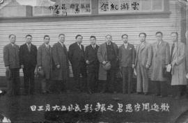
Chinatown Business men - Larry Wong
Collector/curator’s description reads: “1920s, Vancouver. Photo of several men who were part of a Chinese business association. Wong Mow (owner Modern Silk Company; later called Modern Shirt Company) is second from left. Yucho Chow (studio photographer) is fifth from left.”

Yucho w sons and unidentifed man 1936
Collector/curator’s description reads: “1936, Vancouver. Exterior photograph of Yucho Chow Studio at 518 Main Street, Vancouver. The photo shows Yucho Chow standing in front of the store with two of his sons: Peter Chow (second from left) and Jack Chow (far right) as well as unidentified Caucasian man. This photo was taken after 1935 a fire partially destroyed some his studio. The fire began in the rooming house next [door] and spread to the studio.”

Yucho Chow portrait - late 1940s
Collector/curator’s description reads: “Late 1940s, Vancouver. Black and white photograph of photographer Yucho Chow standing next to a large-format camera. In his hand, Yucho is holding the air shutter release.”
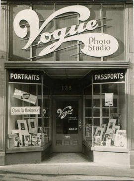
Collector/curator’s description reads: “C. 1944, Vancouver. Photograph of the front of Vogue Photo Studios. Vogue Studios was owned by Yucho Chow and was located at 128 West Hastings Street (Vancouver). Chow's sons Peter and Philip ran this studio, while Yucho continued to operate the main studio at 518 Main Street. Vogue Studio was only in existence a few years (1943-1946) and likely was closed due to the fact that Yucho Chow lost a lawsuit in 1945 and was required to pay his nephew, Chow Neen, $2100.”

Yucho Chow Studio exterior - 1930
Collector/curator’s description reads: “1930, Vancouver. Exterior photo of the front of Yucho Chow Studio at 518 Main Street. The image shows Yucho Chow holding a young child. They are standing behind a car. Part of a neon sign is visible, as well as a large, framed map in the storefront window and customers’ photos. The awning reads ‘PASSPORT PHOTO IN 1 HOUR.’”
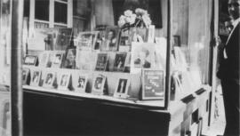
Yucho Chow Studio exterior - 1936
Collector/curator’s description reads: “1936, Vancouver. Exterior photograph of Yucho Chow Studio at 518 Main Street, Vancouver. The photo shows the right side of the store window filled with customers’ photos and a sign that reads ‘Yucho Chow Studio Open Day & Night.’ This photo was taken after 1935 a fire partially destroyed some his studio. The fire began in the rooming house next and spread to the studio.”
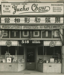
Yucho Chow Studio exterior - 1942
Collector/curator’s description reads: “C. 1943, Vancouver. Photo of front of the Yucho Chow photo studio at 518 Main Street. Chow operated the studio from this location (his fourth location) from 1930 until his death in 1949.”

Roy Perry standing behind counter of the Electric Supply Company store located at 806 Robson Street
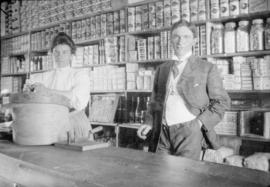
Walter Francis Ing and other employee in Canadian Bag Company
Item is a photograph showing two people at a counter.

Hastings Street, Vancouver, B.C.
Part of L.D. Taylor family fonds
Photograph is a view of the 600 block of West Hastings Street, looking west from Granville Street. S. Blackson, Tobacconist, at 636 West Hastings Street is visible.
![[Board of Trade trip - View of businesses along a street]](/uploads/r/null/9/a/9a202cfd62faff8c39efb52fc9da680f6f2733fda9c5025cef973a204c7703c8/62845f7d-8a0c-4e15-92c6-70fcfc86951e-CVA1477-724_142.jpg)
[Board of Trade trip - View of businesses along a street]
Part of L.D. Taylor family fonds
Photograph taken during Vancouver Board of Trade trip to the Cariboo and northern British Columbia.

Item is a photograph showing the Hammond Furniture property behind the Lipsett Engineering building on Powell Street. According to accompanying notes photograph shows the view "from top of Lipsett Building looking north."
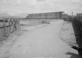
Item is a photograph showing the Hammond Furniture property behind the Lipsett Engineering building on Powell Street. According to accompanying notes photograph shows the view "from South entrance looking north east."

Item is a photograph showing the Hammond Furniture property behind the Lipsett Engineering building on Powell Street. According to accompanying notes photograph shows the view "from railway spur entrance looking north."
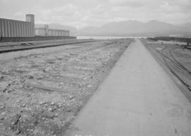
Item is a photograph showing the Hammond Furniture property behind the Lipsett Engineering building on Powell Street. According to accompanying notes photograph shows the view "from south fences approximately 75 paces looking north."

Item is a photograph showing the Hammond Furniture property behind the Lipsett Engineering building on Powell Street. According to accompanying notes photograph shows the view "from approximately half way down yard opposite east side railway spur entrance looking south."
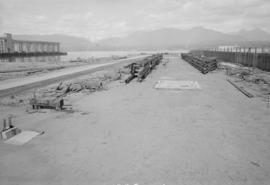
Item is a photograph showing the Hammond Furniture property behind the Lipsett Engineering building on Powell Street. According to accompanying notes photograph shows the view "from approximately half way down yard opposite east side railway spur entrance looking north."

Item is a photograph showing the Hammond Furniture property behind the Lipsett Engineering building on Powell Street. According to accompanying notes photograph shows the view "from north end shore line approximately 113 paces looking north."

Item is a photograph showing the Hammond Furniture property behind the Lipsett Engineering building on Powell Street. According to accompanying notes photograph shows the view "from north end shore line approximately 85 paces looking south."

Item is a photograph showing the Hammond Furniture property behind the Lipsett Engineering building on Powell Street. According to accompanying notes photograph shows the view "from north end looking south."

Item is a photograph showing the Hammond Furniture property behind the Lipsett Engineering building on Powell Street. According to accompanying notes photograph shows the view from: "North end shoreline."
![[Mel Yip standing in front of window of the Wing Sang Company Building at 51 East Pender Street]](/uploads/r/null/b/0/b0cf0dc2bc938d7e5866b6a80e3535a06ddc5f4c74ba218f7f3bc673b5805dc1/8866a29f-8d1c-4e41-977a-6e4a4430b8cd-A70544_142.jpg)
[Mel Yip standing in front of window of the Wing Sang Company Building at 51 East Pender Street]
Mel Yip is a grandson of Yip Sang.
![[Yip Sang with children and family members in front of Wing Sang Company building at 51 East Pender]](/uploads/r/null/f/4/f4e0f636f02f8bf3f04800aa5fa69e34f3a54ca31bcd7af362a1961e71b04f9e/ba070627-f845-473d-9018-3ab7c409260c-A72190_142.jpg)
[Yip Sang with children and family members in front of Wing Sang Company building at 51 East Pender]
Item is a photograph of a photograph showing the Wing Sang Building prior to its expansion in 1901. Individuals identified are: Yip Sang (far left), his number seven son Yip Kew Hong (holding Yip Sang's hand) and his number six son Yip Kew Gin (second from the right).

Photograph shows the Wing Sang Building prior to its expansion in 1901. Yip Sang is on the far left.

Yip Sang is the fifth person from the left.
![[Canton Alley]](/uploads/r/null/8/8/8854bad410df2a72779b09bd8a9091d40f6289e711835cb4bbd085afd90b6428/3e85ba2f-44e4-4064-ade5-a4a17ac6c346-A63452_142.jpg)
Exploring Vancouver’s Chinatown
Item is an educational video produced by the Vancouver School Board for use with a textbook entitled ‘Exploring Vancouver’s Chinatown: A Resource Guide’. The film has no narration, but a background score with Chinese instruments, and scene noise in some places. It opens with footage of the sun rising over Chinatown from a rooftop vantage point. It lingers on vendors and storefronts preparing to open, a Tai Chi class in the Dr. Sun Yat-Sen Garden’s main pavilion, Tai Chi in a local park, scenes of residential streets, houses, schools, and playgrounds. The film includes footage of a variety of local businesses, such as a barbershop, an apothecary, a school, calligraphy, tailor, fire department, auto repair, and a newspaper printer. It concludes with footage of the musicians playing the background music and street scenes of the sun setting over Chinatown.
Linking schools with the community
Item is a promotional film developed to support and promote the Vancouver School Board’s Partners in Education program. The film presents testimonials and success stories from various businesses and schools who have taken advantage of the program, discussing what benefits the partnered schools and businesses were able to bring to each other. The film begins with school administrators and business people talking about the program. The film then presents a number of success stories with various business and schools. The partnerships profiled include: The Port of Vancouver, Chevron Canada, Unisys Canada Inc., University Hospital, the Dr. Sun Yat-Yat Sen Classical Chinese Gardens, the Champlain Mall, the Pan Pacific Hotel, and Vancouver Community College.
The film involves testimonials and short interviews with a number of teachers, school administrators, and business: Jim Matkin (President, BC Business Council), Sheila Tripp (School Principal), Ken Haycock (School Principal), Ken Harvey (Director, Vancouver School Board), Dr. Dante Lupini (Superintendent of Schools, Vancouver), Gwen Smith (School Principal), Barbara Duggan (Vancouver Port Corporation), Gary Ryan (Chevron Canada Ltd), Bill Strachan (Chevron Canada Ltd), Neil Prinsen (Teacher), Maris Pavelson (Unisys Canada Inc.), Sheila Tripp (School Principal), Arlene Cook (Teacher), Lesley Bainbridge (University Hospital), Diane Bolton (Champlain Mall), Joyce Anderson (School Principal), Anne Shorthouse (Program Manager, VSB), Gail Smith (Program Manager, VSB), and Darcy Rezak (Vancouver Board of Trade).

Sheet 21 : Burrard Street to False Creek and waterfront to Robson Street
Part of City of Vancouver fonds
Item is a section showing Burrard Street to False Creek and waterfront to Robson Street. Includes streets and roads; blocks, lots and legal descriptions; the locations of hotels, court house, businesses, parks, and schools; crown leases; C.P.R. land and the company's Piers B and C, yards, sheds and depot; the B.C. Electric Railway Carrall Street Yard; and the Union Steamship Company. Map is hand coloured to show tax sale property for sale, property with no water, street widening and drainage, replotting, reserved land for schools, reserved land for parks, sundry land, capital assets not including schools and parks, schools, and parks, as applicable.
Vancouver (B.C.). Office of the City Engineer

Sheet 22 : Stanley Park to Burrard Street and waterfront to Robson Street
Part of City of Vancouver fonds
Item is a section showing Stanley Park to Burrard Street and waterfront to Robson Street. Includes streets and roads; blocks, lots and legal descriptions. Map shows the locations of Stanley Park, Deadmans Island, marine filling stations, the dredged channel, harbour headline, C.P.R .yards and Pier A, businesses along the waterfront, government buildings, land leases and quit claims. Map is hand coloured to show tax sale property for sale, property with no water, street widening and drainage, replotting, reserved land for schools, reserved land for parks, sundry land, capital assets not including schools and parks, schools, and parks, as applicable.
Vancouver (B.C.). Office of the City Engineer

Part of City of Vancouver Archives technical and cartographic drawing collection
Item is a copy of sections of a November 1889 fire insurance map that have been pieced together. Includes the area between Seymour and Dunlevy Streets, from the south shore of the Burrard Inlet to Keefer Street. Map shows Chinatown, part of False Creek, and buildings and their uses (commercial, residential, industrial). The name of the business, business owner, or type of business is noted for most commercial and industrial buildings.

Sheet 21 : Burrard Street to False Creek and waterfront to Robson Street
Part of City of Vancouver Archives technical and cartographic drawing collection
Item is a section showing Burrard Street to False Creek and waterfront to Robson Street. Includes streets and roads; blocks, lots and legal descriptions; the locations of hotels, court house, businesses, parks, and schools; crown leases; C.P.R. land and the company's Piers B and C, yards, sheds and depot; the B.C. Electric Railway Carrall Street Yard; and the Union Steamship Company.

Sheet 22 : Stanley Park to Burrard Street and waterfront to Robson Street
Part of City of Vancouver Archives technical and cartographic drawing collection
Item is a section showing Stanley Park to Burrard Street and waterfront to Robson Street. Includes streets and roads; blocks, lots and legal descriptions. Map shows the locations of Stanley Park, Deadmans Island, marine filling stations, the dredged channel, harbour headline, C.P.R .yards and Pier A, businesses along the waterfront, government buildings, land leases and quit claims.
Vancouver (B.C.). Office of the City Engineer

Sheet 21 : Burrard Street to False Creek and waterfront to Robson Street
Part of City of Vancouver Archives technical and cartographic drawing collection
Item is a section showing Burrard Street to False Creek and waterfront to Robson Street. Includes streets and roads; blocks, lots and legal descriptions; the locations of hotels, court house, businesses, parks, and schools; crown leases; C.P.R. land and the company's Piers B and C, yards, sheds and depot; the B.C. Electric Railway Carrall Street Yard; and the Union Steamship Company.
Vancouver (B.C.). Office of the City Engineer

Sheet 22 : Stanley Park to Burrard Street and waterfront to Robson Street
Part of City of Vancouver Archives technical and cartographic drawing collection
Item is a section showing Stanley Park to Burrard Street and waterfront to Robson Street. Includes streets and roads; blocks, lots and legal descriptions. Map shows the locations of Stanley Park, Deadmans Island, marine filling stations, the dredged channel, harbour headline, C.P.R .yards and Pier A, businesses along the waterfront, government buildings, land leases and quit claims.
Vancouver (B.C.). Office of the City Engineer

Part of City of Vancouver Archives sound recording and moving image collection
Item is an amateur film documenting Vancouver city lights at night in 1964, including several neon signs and Theatre Row on Granville Street. The film also contains snow scenes and footage of the William Gardner family at Capilano Road in North Vancouver in December 1964 and January 1965, and footage of the family at their West Vancouver home between May and July 1965.
Gardner, William