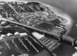
Aerial view of Kitsilano Point, with artist's conception of golf course superimposed on image
- VPK-S625-: CVA 392-1780
- Item
- [ca. 1965]
1079 results with digital objects Show results with digital objects
Aerial view of Kitsilano Point, with artist's conception of golf course superimposed on image

Ferguson Point and Third Beach area

Stanley Park Georgia Street entrance
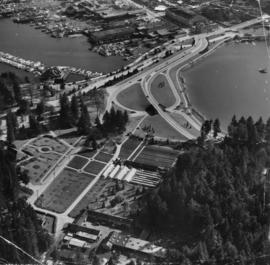
Photograph shows Coal Harbour, Lost Lagoon, greenhouses, and Stanley Park Armouries.
![False Creek Construction and Development [34 of 46]](/uploads/r/null/3/2/325d3cc7927eb0a37268c415423cae1b41ee0beb2d2552166c7551c14723fbc2/93de867a-2f51-44a7-99d2-74ea424568c4-A66432_142.jpg)
False Creek Construction and Development [34 of 46]
Part of City of Vancouver fonds
![False Creek Construction and Development [33 of 46]](/uploads/r/null/0/8/0847c9194674abb075e139a51985f8667203c8557e6200c28593021f7e88c9a1/b662d55e-dfa9-41ac-a66c-8c01c50008a5-A66431_142.jpg)
False Creek Construction and Development [33 of 46]
Part of City of Vancouver fonds
![False Creek Construction and Development [32 of 46]](/uploads/r/null/4/b/4b603b6bc6cb92815ca616a42462305634b9f84c5c2e1705caf02a83efccb0ba/bd80820d-2172-4bbd-80bf-c64a0fb2a357-A66430_142.jpg)
False Creek Construction and Development [32 of 46]
Part of City of Vancouver fonds
![False Creek Construction and Development [31 of 46]](/uploads/r/null/9/2/9205574976d816ba47d939bda896f3fde94e94c8a0f2481dbf912b7a77c24ce7/d7044b05-18e0-4ec3-b11a-31e6b126a974-A66429_142.jpg)
False Creek Construction and Development [31 of 46]
Part of City of Vancouver fonds
![False Creek Construction and Development [30 of 46]](/uploads/r/null/6/b/6b031ac9ab7b93832c88468a6bed93e9af88daf76f562ebbfb5528fbd97716b4/be48b00a-284e-40da-9df9-cae43a163b18-A66428_142.jpg)
False Creek Construction and Development [30 of 46]
Part of City of Vancouver fonds
![False Creek Construction and Development [29 of 46]](/uploads/r/null/d/8/d8b2bf2de1b32f72b54508607b94dcedd7009fd72d3c2f00a53fb77f58f5b764/4fe12044-b7d7-4a83-b3a0-fbe668b49d7d-A66427_142.jpg)
False Creek Construction and Development [29 of 46]
Part of City of Vancouver fonds
![False Creek Construction and Development [16 of 46]](/uploads/r/null/b/7/b7f25fc0ce57359846902658629950abe6516aa23007aa6d7221379c8ca686f3/62e1a447-9428-4078-8c33-246592c8c97e-A66414_142.jpg)
False Creek Construction and Development [16 of 46]
Part of City of Vancouver fonds
![Garbage landfill - Old pictures [30 of 31]](/uploads/r/null/4/9/490393469a998dbcedfb345eacc21abf127e329df37475cba50526f6a94f373c/de4767a7-476d-4d35-bdb2-48e2ca8e9c87-A66366_142.jpg)
Garbage landfill - Old pictures [30 of 31]
Part of City of Vancouver fonds
![Garbage landfill - Old pictures [29 of 31]](/uploads/r/null/2/3/23d6c22931868695746ed0ab4398d7008ebac87e7bdc25b2e854c1030b03f286/49e042b7-db6e-421b-9fee-49195dc452cb-A66365_142.jpg)
Garbage landfill - Old pictures [29 of 31]
Part of City of Vancouver fonds
![Garbage landfill - Old pictures [28 of 31]](/uploads/r/null/6/2/62463a3d6bc7ab9f4c03f69fc729c0b4ebbe03542fee5175ba4a0eb2f67f1e69/c79babe6-e4d2-4c88-b6a9-dadff10c737a-A66364_142.jpg)
Garbage landfill - Old pictures [28 of 31]
Part of City of Vancouver fonds
![Garbage landfill - Old pictures [27 of 31]](/uploads/r/null/5/7/57015e8cb40d30c2615184c4bf7e57b93ef971a5037a42e36c4fdd16fac9f423/de5606a8-8718-475f-b5e9-cd2ebb097b44-A66363_142.jpg)
Garbage landfill - Old pictures [27 of 31]
Part of City of Vancouver fonds
![Garbage landfill - Old pictures [26 of 31]](/uploads/r/null/c/9/c9cd67ddd2828a8f66987e920614a10f36bd85aef5be38411b1db97da911fa76/2fb23205-6d62-45c9-bcdc-c526bbd197e1-A66362_142.jpg)
Garbage landfill - Old pictures [26 of 31]
Part of City of Vancouver fonds
![Garbage landfill - Old pictures [25 of 31]](/uploads/r/null/5/0/5077507d68c287c6488b7347abb1565f3bf127721e50d4f0116fca5f5804ce29/6cd10d11-0620-4d4a-9c90-4bf58fe354b3-A66361_142.jpg)
Garbage landfill - Old pictures [25 of 31]
Part of City of Vancouver fonds
![Garbage landfill - Old pictures [24 of 31]](/uploads/r/null/c/c/cc338661ac851aa511fa08074b44d8d303a43627b21e381fc6d750c38baa0b33/af33bbd4-bc4f-425a-b550-6ceffe96e51c-A66360_142.jpg)
Garbage landfill - Old pictures [24 of 31]
Part of City of Vancouver fonds
![Garbage landfill - Old pictures [23 of 31]](/uploads/r/null/3/2/3268504596e0b7668d8d7b73368411bd0efd26468a9bb6c47bc19f6e5893227a/dfeb33ea-7f30-4c41-ae9e-9ce3cda9d628-A66359_142.jpg)
Garbage landfill - Old pictures [23 of 31]
Part of City of Vancouver fonds
![Garbage landfill - Old pictures [22 of 31]](/uploads/r/null/1/6/1629ff01fc83ca2f37b4d8155019d21781b81faf842f824ec86a4b63bf59c513/adc7b2b1-1095-485e-8464-6386e49962b5-A66358_142.jpg)
Garbage landfill - Old pictures [22 of 31]
Part of City of Vancouver fonds
![Garbage landfill - Old pictures [21 of 31]](/uploads/r/null/f/a/fa41af6b3d1952074bbf76248185156be6015a0b34c8305f91d5a33e6d604768/ee42a0f0-0fa7-4904-aee5-0c69b95f162d-A66357_142.jpg)
Garbage landfill - Old pictures [21 of 31]
Part of City of Vancouver fonds
![Garbage landfill - Old pictures [20 of 31]](/uploads/r/null/7/c/7cc6b2058aa21dddca9e4d4f13e4cfd4ba150bf7c95e5f5cfa2d6f0181a85c43/1dcbef78-c3ae-4895-9b59-ffef580d0d5d-A66356_142.jpg)
Garbage landfill - Old pictures [20 of 31]
Part of City of Vancouver fonds
![Garbage landfill - Old pictures [19 of 31]](/uploads/r/null/7/3/73a20f15559f5b13ce3bf3c4a62207d63a3768bc34c324024b6dbd6456a746c6/2ef242b7-ba65-4fb3-a10e-b40bc96bdca6-A66355_142.jpg)
Garbage landfill - Old pictures [19 of 31]
Part of City of Vancouver fonds
![Garbage landfill - Old pictures [18 of 31]](/uploads/r/null/d/0/d040038fed80dd33a6672bf5bc76e322ebf322d702a54c8232f84ad1be4cffa8/5d3d7160-7fd1-4647-a556-72e1814a3292-A66354_142.jpg)
Garbage landfill - Old pictures [18 of 31]
Part of City of Vancouver fonds
![Garbage landfill - Old pictures [17 of 31]](/uploads/r/null/b/2/b2a7e5c925bb47f2b66d7a6d618eb39ab16deac7440c2240c8ca5cb1250b6485/147092f2-7408-49c2-8992-a3a848b58183-A66353_142.jpg)
Garbage landfill - Old pictures [17 of 31]
Part of City of Vancouver fonds
![Garbage landfill - Old pictures [16 of 31]](/uploads/r/null/6/d/6d54b09f3f17e444eaaeaf1171430396e92538cc2c5102751b4705dbc06674b4/8c0e78af-2237-44d2-98af-5cd010c3daf8-A66352_142.jpg)
Garbage landfill - Old pictures [16 of 31]
Part of City of Vancouver fonds
![Garbage landfill - Old pictures [15 of 31]](/uploads/r/null/b/f/bf026c4ad6c00d44c4be6cede0e04e2a487501471a0c14c2066b87d3ad8cb618/055d3f5b-3b53-4c73-9d7d-0501d04b2f13-A66351_142.jpg)
Garbage landfill - Old pictures [15 of 31]
Part of City of Vancouver fonds
![Garbage landfill - Old pictures [14 of 31]](/uploads/r/null/f/4/f40eeef962d8de76f02f1c133703296d9fb63530c300417ae08c28c5c8833b54/65308e29-ed50-498c-9967-7f6a2595696a-A66350_142.jpg)
Garbage landfill - Old pictures [14 of 31]
Part of City of Vancouver fonds
![Garbage landfill - Old pictures [13 of 31]](/uploads/r/null/9/6/9611a9971bf09c4fa37dddab2fd6cca6f4bb4ce1339b9078ff4ae26796e4f09a/c54820a5-e089-4481-a805-6c5d594c5f18-A66349_142.jpg)
Garbage landfill - Old pictures [13 of 31]
Part of City of Vancouver fonds
Item is a photograph showing an aerial view the Kerr Road garbage site.
![Aerial pix of various landfill [2 of 2]](/uploads/r/null/e/7/e7703b220e446009ac90537bc812e9b18d5961bc3bef9af08496b7511b215a5c/b6eff842-b01a-4f53-9052-d169441bc572-A66348_142.jpg)
Aerial pix of various landfill [2 of 2]
Part of City of Vancouver fonds
![Aerial pix of various landfill [1 of 2]](/uploads/r/null/4/b/4b64f19cdf8c8c258da84bd571f35c13db694387c6a0eda63ffe8975f1c34a7a/aaf98564-d3f5-4bd4-a4d5-3269ac147dcc-A66347_142.jpg)
Aerial pix of various landfill [1 of 2]
Part of City of Vancouver fonds
![[View looking northeast from north shore of False Creek over Smithe Street]](/uploads/r/null/8/f/6/8f6d7814ac04d1498743ba52bf07caf7e8dd2cf0290eb319665712b1edfdc180/c5c831e7-835b-48ff-8c87-5c157412dc0c-CVA145-2_142.jpg)
[View looking northeast from north shore of False Creek over Smithe Street]
Part of City of Vancouver fonds
![[Aerial view of] downtown bounded by Burrard Street, West Georgia Street, Granville Street and Sm...](/uploads/r/null/9/1/a/91aa0079c35a13cc3a22b0f7df0fb214970095aab0b5d871e09523e0499e3dac/42b18aee-e75f-4548-9e3a-bf196c0130ce-CVA145-17_142.jpg)
Part of City of Vancouver fonds
![[Aerial view of] old Cambie Bridge, looking north](/uploads/r/null/e/4/e/e4ec2308129a57f09e5cbdc76587997001f8d0ee7827c7457a74581831b64c92/fa92b5dd-9264-42ea-8f50-dcbf02b02d1a-CVA145-16_142.jpg)
[Aerial view of] old Cambie Bridge, looking north
Part of City of Vancouver fonds
![[Aerial view of Vancouver] sawmill and West Coast Hardwood Ltd, 7th Avenue and Clark Drive](/uploads/r/null/9/0/b/90bb9ab825876d633ac9282b128e51a609b2d9249375b17ac9a5a9466f055f24/44a65d73-fb54-4de9-beaa-497a8bbf79ab-CVA145-15_142.jpg)
[Aerial view of Vancouver] sawmill and West Coast Hardwood Ltd, 7th Avenue and Clark Drive
Part of City of Vancouver fonds
Item is a photograph looking north, showing the velodrome and Clark Drive between Broadway and First Avenue.
![[Aerial view of] Victoria Drive and Pandora [Street]](/uploads/r/null/9/5/9/959fb0c9a58d92f88a5ccb6f239e0ee67e102f59511de48f2d825c37983b7e63/e36283e1-1eca-4e4c-b287-c94f2363af28-CVA145-14_142.jpg)
[Aerial view of] Victoria Drive and Pandora [Street]
Part of City of Vancouver fonds

Project 2, part of area "a" : aerial photograph
Part of City of Vancouver fonds
Item is a map showing the boundaries of clearance areas for project 1 (sub areas 1, 2 & 3) and project 2 (sub areas 5, 6 & 7). These areas have been outlined in yellow.

Project 2, part of area "a" : aerial photograph
Part of City of Vancouver fonds
Item is a map in the form of an aerial photograph, which depicting the part of the city covered by the project: from Railway Street in the north to Prior Street in the south and from Clark Drive in the east to Main Street in the west.
Attached label indicates that the map was approved by Council Sept. 17, 1963.
![[Aerial view of City of Vancouver, image of printed photograph]](/uploads/r/null/a/6/5/a6568a4fca40576b2d2b079a13541a80ace37c89086c2a64db6237dfdb087262/fb145724-094b-4d2e-9a60-24df3aef9c61-CVA1095-06997_142.jpg)
[Aerial view of City of Vancouver, image of printed photograph]
Part of City of Vancouver fonds
![[Aerial view of City of Vancouver, image of printed photograph]](/uploads/r/null/3/b/6/3b6df85f34e645db70d12e261cd1a8c0cea08edc95e2716ce32a92dc881a5878/efd40a47-faf5-435c-8b80-2f9099c88723-CVA1095-06996_142.jpg)
[Aerial view of City of Vancouver, image of printed photograph]
Part of City of Vancouver fonds
![[Aerial view of City of Vancouver, image of printed photograph]](/uploads/r/null/f/3/2/f3234fb45e4f46831886bd2cb6694f50a56ee898e4f2bd5b62dac4912067f52e/e5d60571-6952-41a6-8a5f-aba132b36f28-CVA1095-06995_142.jpg)
[Aerial view of City of Vancouver, image of printed photograph]
Part of City of Vancouver fonds
![[Aerial view of City of Vancouver, image of printed photograph]](/uploads/r/null/7/0/d/70d11e62ad0119a7483a61fe5f3229fcc4e1aacd651e6722db2466c5a80a8dcb/35b64a80-d60d-4551-89eb-87a5b81ac347-CVA1095-06994_142.jpg)
[Aerial view of City of Vancouver, image of printed photograph]
Part of City of Vancouver fonds
![[Aerial view of City of Vancouver, image of printed photograph]](/uploads/r/null/8/0/3/80337fd039988f10176eb1c593eb6cacff2aceac861957b1ea4b7be13e8b5ce7/1bdf7acc-f42b-4f15-bd32-4d7c837f7829-CVA1095-06993_142.jpg)
[Aerial view of City of Vancouver, image of printed photograph]
Part of City of Vancouver fonds
Aerial view of Pier B, C and A at the foot of Burrard Street
Part of City of Vancouver fonds

Aerial view of Coal Harbour and Stanley Park
Part of City of Vancouver fonds

Aerial view of Burrard Street and surrounding area
Part of City of Vancouver fonds

Part of City of Vancouver fonds
Photograph shows the Burrard Bridge, the R.C.A.F. Equipment Depot on Kits Point, the Granville Bridge, Granville Island, Brockton Point, Deadmans Island and the North Shore mountains in the background

Aerial view of the City of Vancouver, Redevelopment Project No. 1
Part of City of Vancouver fonds

Aerial view of the downtown core, post office under construction
Part of City of Vancouver fonds

Part of City of Vancouver fonds
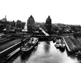
Item is a photograph showing the east end of False Creek. From just west of Columbia Street to just east of Main Street, West 2nd Avenue to Keefer Street. Includes the Georgia Viaduct and Dunsmuir Viaduct.