Aerial views of the Westcoast Transmission Building
- AM1435-F4
- File
- [1970?]
1079 results with digital objects Show results with digital objects
Aerial views of the Westcoast Transmission Building
Westcoast - Building Construction (WCB) binder, 1969-1980
File consists of photographs showing the Westcoast Transmission Building at 1333 West Georgia including the various stages of construction showing views taken from atop building, the core, floors, workers operating equipment as well as photographs showing executives breaking ground, the repair of building cables, and aerial views of the building downtown.
File consists of 32 photographs showing aerial views of the Vancouver Airport, Sea Island, Richmond, and the Fraser River. Also included are various shots showing the belly-landing of a small airplane.
Fonds consists of photographs showing primarily views of downtown Vancouver including prominent buildings, aerial views, commercial and residential properties, as well as the Larwill Park area, and the phases of construction for the former Westcoast Transmission building at 1333 West Georgia Street. The fonds also includes a few photographs from over Vancouver locations, including along Broadway and aerial views of different parts of the city.
![[Eastern view of Vancouver's waterfront]](/uploads/r/null/e/6/e6c8b31b7f9fdcdb39ea15c2f8c416643495406655370ab1b0674baefc887af3/c5f54d6e-fafc-4db5-840f-ee6af9f443ec-A43370_142.jpg)
[Eastern view of Vancouver's waterfront]
Part of Major Matthews collection
Oblique view showing Ballantine Pier, Buckerfields, the Second Narrows (cantilever) Bridge and the North Shore in the background
![[Burrard Dry Dock from the air]](/uploads/r/null/f/6/f697efd23e2530d394af63aea6c7ce4ff6241e55b1020a7b50e6b59f588d3c9b/546ed067-3280-4554-b322-b4cdedc13652-A43331_142.jpg)
[Burrard Dry Dock from the air]
Part of Major Matthews collection
Oblique view
Part of Major Matthews collection
Oblique view looking northeast showing the Denman Arena, the Georgia Street entrance to Stanley Park, the Vancouver Rowing Club, Brockton Point and Deadmans Island

Part of Major Matthews collection
Oblique view looking north across the north arm of the Fraser River towards Marpole

Part of Major Matthews collection
Oblique view showing sawmills on the north arm of the Fraser River
![[Aerial view looking east towards the Second Narrows (Iron Workers Memorial) Bridge]](/uploads/r/null/a/3/a30e769b11d82234857ac24837baf510f2440359b92782f8e65bf107d5c50ffe/d0897c6d-49e8-4e61-b76c-6f04433a9e5b-A43252_142.jpg)
[Aerial view looking east towards the Second Narrows (Iron Workers Memorial) Bridge]
Part of Major Matthews collection
Oblique view showing the cantilever open
![Vancouver B.C. [from the air looking east from West End]](/uploads/r/null/a/3/a39a59fafd2c470a05e0b8ecba90843c0dcefd64faa8cd1695e25e8515c52ad7/4a63a71b-9508-45ea-b75a-27924fe36db8-A42964_142.jpg)
Vancouver B.C. [from the air looking east from West End]
Part of Major Matthews collection
Photograph shows buildings and houses along West Georgia Street and Pender Street.
![[Aerial view looking west over Point Grey]](/uploads/r/null/d/a/da370c91b8519769814da89cd1136fcd3872aa71fca7a7f1b176e6534e9caaef/a1ff0d0e-189b-42d3-9ad4-090a410a7ea2-A43251_142.jpg)
[Aerial view looking west over Point Grey]
Part of Major Matthews collection
Oblique view showing the Jericho Beach Golf Course and the R.C.A.F. aerodrome
![[Aerial view looking north over Downtown]](/uploads/r/null/4/b/4b54e616319b32d55e40e5c7404b5eccbd9b053f144a101245a1e709d1cfd4d2/1752a263-31cd-4155-880a-ead0fa54c115-A43250_142.jpg)
[Aerial view looking north over Downtown]
Part of Major Matthews collection
Oblique view showing part of the West End, the north end of the Granville Street and C.P.R. Kitsilano Trestle bridges, log booms, industries and the waterfront of False Creek and the C.P.R. docks and Burrard Inlet in the background
![[Aerial view looking east over Point Grey]](/uploads/r/null/6/e/6e6142341e688a43c05c88b90455b7a0b9857daa4b8b976c384474e010017e9b/d7b03617-741e-42e1-a20f-006407c2e6be-A43249_142.jpg)
[Aerial view looking east over Point Grey]
Part of Major Matthews collection
Oblique view
![[Aerial view looking east over Stanley Park, Coal Harbour and Burrard Inlet]](/uploads/r/null/d/0/d02fee694c486ac2accdeefb505d0dae5fcb42789ef16de49322d845e3c04b44/be8c34ce-7c09-4c0e-a395-f083c9134080-A43248_142.jpg)
[Aerial view looking east over Stanley Park, Coal Harbour and Burrard Inlet]
Part of Major Matthews collection
Oblique view
![[Aerial view looking north from False Creek]](/uploads/r/null/0/8/081746026b1559c2ace13027d77c668cba79e15800d0ca6ca466b205529e45b3/ce072490-3b01-4b65-8d61-bfaa102cca83-A43247_142.jpg)
[Aerial view looking north from False Creek]
Part of Major Matthews collection
Oblique view showing the West End and Downtown in the background
![[Aerial view of the piers on the waterfront of] Vancouver, B.C.](/uploads/r/null/2/0/20aba7c72fbaff48163c905a081b26e279ffb5c8bb90db511f18e1662152abb5/aeaa6a64-f52b-4521-a874-dcce97de484f-A43206_142.jpg)
[Aerial view of the piers on the waterfront of] Vancouver, B.C.
Part of Major Matthews collection
Oblique view looking east from Coal Harbour showing fuel tanks, the C.P.R. piers and other docks and the Marine Building
![[View looking east from Main Street and Pender Street]](/uploads/r/null/8/0/809cf6a26840094bf6d8fe3ddd67086496a879a0bb94d26685982dda7e6f42a7/0bafdc9e-9e34-4fc8-9e04-8b7bcfd96944-A43299_142.jpg)
[View looking east from Main Street and Pender Street]
Part of Major Matthews collection
Oblique view
![Vancouver, B.C. [from the air looking east from Lost Lagoon]](/uploads/r/null/5/1/5127fcacb95395f95ba7c0f104a40a408b7f3d76e10c9881ebcc71cfc1a7c5de/ee54b68d-1f24-417f-b491-0956e3d4522f-A42965_142.jpg)
Vancouver, B.C. [from the air looking east from Lost Lagoon]
Part of Major Matthews collection
Oblique view showing the Denman Arena, the Horse Show building, the Coal Harbour waterfront and the West End

Part of Major Matthews collection
Oblique view showing Brockton Point and the Marine Building and the second and third Hotel Vancouvers in the background
![[Aerial view showing the northwestern section of Downtown]](/uploads/r/null/d/a/da84098b0ef036990e34132f726d1491bbbb1fc247cc76fc6659886372017fdc/a8601693-c900-4d47-a380-9979b203400b-A43287_142.jpg)
[Aerial view showing the northwestern section of Downtown]
Part of Major Matthews collection
Oblique view showing Deadman's Island, Coal Harbour, Brockton Point, the First Narrows, the Lion's Gate Bridge and North and West Vancouver in the background
![[Aerial view looking northwest over Downtown]](/uploads/r/null/b/7/b7ca69254d2cbe14ffd3cb21ed6f3b1fed68dde7a4a5843876f8c173674d9d01/a1129a0c-5269-4488-9376-66246af93f6d-A43286_142.jpg)
[Aerial view looking northwest over Downtown]
Part of Major Matthews collection
Oblique view showing the Cambie Street Bridge, the Georgia Viaduct, Pier B-C, Stanley Park, Coal Harbour, the Lion's Gate Bridge and West Vancouver in the background

Georgia Street Vancouver, B.C.
Part of Major Matthews collection
Oblique view looking east along Georgia Street from Broughton Street showing the Felix Apartments on Jervis Street, The Hotel Vancouver, Christ Church Cathedral and other buldings
Part of Major Matthews collection
Oblique view showing the Burrard Bridge under construction, the Kitsilano Trestle, Granville and Cambie Bridges, Kitsilano, Granville Island, False Creek, Fairview, Mount Pleasant, Yaletown, Downtown, West End, Stanley Park and Vancouver Harbour

Part of Major Matthews collection
Oblique view shows the court house, H.B. Co. building and the Vancouver Block.

Prince George, British Columbia
Part of Major Matthews collection
Oblique view
![[Aerial view looking east of downtown Vancouver and the waterfront]](/uploads/r/null/a/1/a146c28159c45997dd3312d8a94967907da12e5b5c1139902f95665ab0e54675/740905a3-6e61-4ffc-bc08-d90ad82bc7d8-A67011_142.jpg)
[Aerial view looking east of downtown Vancouver and the waterfront]
Part of Major Matthews collection
Oblique view shows the Immigration buildings, C.P.R. Piers A, B and C, the Courthouse, Hotel Vancouver, Marine building and Vancouver block.
![[H.M.C.S. "Vancouver"]](/uploads/r/null/4/0/40d05283991f8a914e2f61116a8aa8fdd34edba558afb1cedac93df18b745017/22fe1139-eab9-4358-ac03-5356b4e12a8a-A67012_142.jpg)
Part of Major Matthews collection
![[Aerial view of Vancouver and Burnaby]](/uploads/r/null/f/b/fbdba44a19d2b4928094d872a6a16513550380c67160420213fe19581531e9c6/bb3aa326-0dd0-4dbe-879c-2a4a1527d49f-A66597_142.jpg)
[Aerial view of Vancouver and Burnaby]
Part of Major Matthews collection
Photograph shows Vancouver Technical School, Grandview Highway and Renfrew Playing Fields.
![[Aerial view of Mount Pleasant, South Strathcona and Kensington-Cedar Cottage]](/uploads/r/null/7/5/75ea991fe8319eaffda79b314cbf20e281e35eb2cd8a89eaa898b492242d6282/05f856f3-0a45-41eb-94dc-46cb9d2f7ecf-A63348_142.jpg)
[Aerial view of Mount Pleasant, South Strathcona and Kensington-Cedar Cottage]
Part of Major Matthews collection
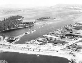
Photograph shows aerial view of the east end of False Creek, Thornton Park, Great Northern Railway and Canadian National Railway yards, Mount Pleasant, Strathcona, Grandview-Woodland, Trout Lake, Kingsway, Vancouver Technical School grounds, Renfrew playing fields, John Hendry Park, British Columbia Electric Railway Right of Way, Clark Park, Grandview Highway South, Great Northern Railway.
![[Aerial view of Vancouver]](/uploads/r/null/b/9/b973b9a4143a5316b02e728c35d99e383f27a3db21d8e20aa7bbb459780243bc/3ff38b56-6b36-4c17-bce1-329c97459d29-A66598_142.jpg)
Part of Major Matthews collection
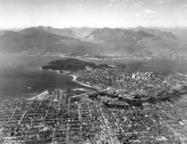
Photograph shows Kitsilano, Kits Point, Kitsilano Beach, R.C.A.F. Equipment Depot, Kitsilano Pool, Burrard Bridge, C.P.R. Kitsilano Trestle, Granville Island, Granville Bridge, Cambie Bridge, False Creek, C.P.R. False Creek Yards, West End, Yaletown, Arbutus Ridge, Shaughnessy, South Cambie, Fairview, Mount Pleasant, Little Mountain Reservoir, Connaught Park, Quilchena Golf Course, Douglas Park, Shaughnessy Heights Golf Course, Queen Elizabeth Park, Royal Canadian Mounted Police Barracks, Shaughnessy Military Hospital, Hillcrest Park, Robertson & Hacket Sawmill, City Yard, West Coast Ship Builders and Athletic Park.
![[Aerial view of West Point Grey, Kitsilano, Dunbar - Southlands and University Endowment Lands]](/uploads/r/null/0/8/089d213e9a81ca689130a244122a86972e068c9b01ab994922a88072ac881121/1ed71859-c157-4686-82db-e3483cd4b877-A66599_142.jpg)
[Aerial view of West Point Grey, Kitsilano, Dunbar - Southlands and University Endowment Lands]
Part of Major Matthews collection
Photograph shows the south Slope of English Bay, Spanish Banks, Locarno Beach Park, Jericho Beach, R.C.A.F. Jericho Air Station, Kitsilano pool, Connaught Park and Kitsilano Beach Park, Caldecott Park, Quilchena Golf Course, School for Deaf and Blind and Quesnel Park.
![[Aerial view of Burrard Inlet, Hastings-Sunrise, Burnaby and the District of North Vancouver]](/uploads/r/null/d/f/df7e11c97173ce0473c454f0a01569b641972f6efdc12bf192edbc42119542d6/6d72f89b-9b55-48c4-bef6-04eb2137f1d3-A66600_142.jpg)
[Aerial view of Burrard Inlet, Hastings-Sunrise, Burnaby and the District of North Vancouver]
Part of Major Matthews collection
Photograph shows Exhibition Park and P.N.E. Golf Course, Second Narrows Bridge, New Brighton Park, Callister Park, Burrard Inlet, Lynn Creek, Lynn Park, Seymour Creek, Vancouver Harbour Commissioners Railway, Inspected Shingles Ltd., Cascade Rock and Gravel Co. Ltd., Canadian Shingle Co. Ltd. (Capilano Timber Co. Ltd.), Alberta Pool Elevator, Columbia Grain Elevator Co. Ltd., Canadian Pacific Railway, Girls Industrial School and Old Peoples Home sites.
![[Aerial view of Burrard Inlet, Vancouver waterfront and North Vancouver waterfront]](/uploads/r/null/7/e/7ebb42bad115eb635562fde51fb418b1e63ecf9048f15193681f167f6966c96a/874ecdbf-b7e9-4561-b45f-1003efcc073f-A66601_142.jpg)
[Aerial view of Burrard Inlet, Vancouver waterfront and North Vancouver waterfront]
Part of Major Matthews collection
Photograph shows L-R: Evans Coleman & Evans Warehouses, North Vancouver Ferry Wharf, Canadian National Steamships Pier, Canadian Fish Co., Ballantyne Pier, Great Northern Railway Pier and shed, Balfour Guthrie Freight shed, Pacific Mills Ltd., B.C. Sugar Refinery Co., Hastings Shingle Mills, LaPointe Pier B-C, Marine Engineering & Ship Builders Ltd., Terminal Dock & Warehouse and Burrard View Park.

Part of Major Matthews collection
Photograph shows Lions Gate Bridge, Beaver Lake, Lost Lagoon, Prospect Point, Brockton Point, Deadman's Island, Royal Vancouver Yacht Club, H.M.C.S. Discovery, Brockton Oval and English Bay.
Aerial photograph of downtown Vancouver, south shore False Creek, North and West Vancouver
Welcome to Vancouver a complimentary guide to Vancouver international airport and the city
![[Aerial view of the Cleveland Dam and Capilano Lake]](/uploads/r/null/2/d/2dd436651b825b9f47ef30c7faef322e33a7a58fafcada712d5da71134736c7d/af2b6b11-8b8c-4e04-9855-a2c6380c8e6f-A33749_142.jpg)
[Aerial view of the Cleveland Dam and Capilano Lake]
Part of Major Matthews collection
Oblique view
![[Aerial view of the Cleveland Dam, Capilano Lake and a portion of the Glenmore subdivision]](/uploads/r/null/3/9/399b03da5e7aff8921c363411aff0ff59308b840b0fcf3d1f9e45e54612a6398/241ed6bf-dc7b-4f29-930e-542982da6184-A33748_142.jpg)
[Aerial view of the Cleveland Dam, Capilano Lake and a portion of the Glenmore subdivision]
Part of Major Matthews collection
Oblique view
![[Aerial view of Ripple Rock prior to blasting in the Seymour Narrows ]](/uploads/r/null/2/a/2a502b9f749a5237c71cd2eebffdb5d9cf761c2fe79592e06d90aa7d2fdcb122/d8917a3e-684b-4ed5-aff6-4c4fee905c19-A33747_142.jpg)
[Aerial view of Ripple Rock prior to blasting in the Seymour Narrows ]
Part of Major Matthews collection
Oblique view

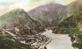
In The Fraser Canyon at Yale, B.C.
Part of Major Matthews collection
Oblique view

Cape Mudge Lighthouse from the Air
Part of Major Matthews collection
Oblique view
![[Aerial view of a Trans-Canada flight over the Legislature Buildings]](/uploads/r/null/2/c/2c11ee8d03efbcf7ecadfbef3e61bc88240bece54cf13185b1a31de5f44ee0e8/554c34a1-7b7a-4613-bfd4-d5e38c3aa6a1-A33475_142.jpg)
[Aerial view of a Trans-Canada flight over the Legislature Buildings]
Part of Major Matthews collection
Oblique view
![[Aerial view of Vancouver showing West and North Vancouver in the distance]](/uploads/r/null/8/d/8d777f00e47e79c44a6ac156af179a087158c26ea0c533480d2a2fb614a2f72e/3d4beb27-2bde-4b39-9fa9-51ad4fca5418-A37529_142.jpg)
[Aerial view of Vancouver showing West and North Vancouver in the distance]
Part of Major Matthews collection
Oblique view showing hand-drawn Burrard, Kitsilano Trestle, Granville, Cambie Street and Lion's Gate Bridges, the causeway through Stanley Park and the street system of Capilano Estates
![[Aerial view of Tofino]](/uploads/r/null/8/1/81c09684e8d4571f12e01787f91c039df91a24e8aacac39932ebe70471e03f55/cc49f384-8d43-44c3-b3d0-d7684a374215-A33420_142.jpg)
Part of Major Matthews collection
Oblique view
![[Aerial view of Ucluelet]](/uploads/r/null/c/8/c8cece718ec98f75d48c6cdd551d9b6e231b87f8401a1d00040d893672754082/ea50645d-b743-42fa-bd2b-e85f95662230-A33419_142.jpg)
Part of Major Matthews collection
Oblique view
![[View of the Swift Canadian Company Limited property and buildings]](/uploads/r/null/a/9/a94fbd27681be80f3d9a714c4b8dbb6eddae9d0e900935f390887b0579aeafa2/b0dd9a53-265d-4196-8cb8-b16a0bbbafc5-A33287_142.jpg)
[View of the Swift Canadian Company Limited property and buildings]
Part of Major Matthews collection
![[View of Pasley Island in Howe Sound]](/uploads/r/null/5/6/56ccb0c9a28a04d8d9eea97ed1f83c3199ad3a9e83a6a6f772a9d888668dbd89/f4a51183-b104-4fdf-984e-4486f9cc57a1-A33259_142.jpg)
[View of Pasley Island in Howe Sound]
Part of Major Matthews collection
Oblique view
![[The Malibu Club from the air]](/uploads/r/null/8/4/84af9ce4b59a192b718b53f0cc73247ecb96e71fc39ca29a306561109eae9386/f24d271e-7bc5-4c99-871b-b40a888223ac-A33224_142.jpg)
[The Malibu Club from the air]
Part of Major Matthews collection
Oblique view