Aerial views of the Westcoast Transmission Building
Aerial views of the Westcoast Transmission Building
Westcoast - Building Construction (WCB) binder, 1969-1980
Westcoast - Building Construction (WCB) binder, 1969-1980
Tom Wong Collection
Tom Wong Collection
Tom Grant fonds
Tom Grant fonds
![[Eastern view of Vancouver's waterfront]](/uploads/r/null/e/6/e6c8b31b7f9fdcdb39ea15c2f8c416643495406655370ab1b0674baefc887af3/c5f54d6e-fafc-4db5-840f-ee6af9f443ec-A43370_142.jpg)
[Eastern view of Vancouver's waterfront]
![[Burrard Dry Dock from the air]](/uploads/r/null/f/6/f697efd23e2530d394af63aea6c7ce4ff6241e55b1020a7b50e6b59f588d3c9b/546ed067-3280-4554-b322-b4cdedc13652-A43331_142.jpg)
[Burrard Dry Dock from the air]
Coal Harbour Vancouver, B.C.

B.C.E.R. Bridge Marpole

B.C.E.R. Bridge Marpole
![[Aerial view looking east towards the Second Narrows (Iron Workers Memorial) Bridge]](/uploads/r/null/a/3/a30e769b11d82234857ac24837baf510f2440359b92782f8e65bf107d5c50ffe/d0897c6d-49e8-4e61-b76c-6f04433a9e5b-A43252_142.jpg)
[Aerial view looking east towards the Second Narrows (Iron Workers Memorial) Bridge]
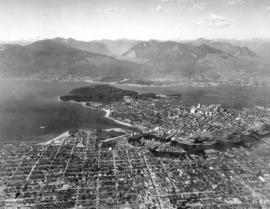
![Vancouver B.C. [from the air looking east from West End]](/uploads/r/null/a/3/a39a59fafd2c470a05e0b8ecba90843c0dcefd64faa8cd1695e25e8515c52ad7/4a63a71b-9508-45ea-b75a-27924fe36db8-A42964_142.jpg)
Vancouver B.C. [from the air looking east from West End]
![[Aerial view looking west over Point Grey]](/uploads/r/null/d/a/da370c91b8519769814da89cd1136fcd3872aa71fca7a7f1b176e6534e9caaef/a1ff0d0e-189b-42d3-9ad4-090a410a7ea2-A43251_142.jpg)
[Aerial view looking west over Point Grey]
![[Aerial view looking north over Downtown]](/uploads/r/null/4/b/4b54e616319b32d55e40e5c7404b5eccbd9b053f144a101245a1e709d1cfd4d2/1752a263-31cd-4155-880a-ead0fa54c115-A43250_142.jpg)
[Aerial view looking north over Downtown]
![[Aerial view looking east over Point Grey]](/uploads/r/null/6/e/6e6142341e688a43c05c88b90455b7a0b9857daa4b8b976c384474e010017e9b/d7b03617-741e-42e1-a20f-006407c2e6be-A43249_142.jpg)
[Aerial view looking east over Point Grey]
![[Aerial view looking east over Stanley Park, Coal Harbour and Burrard Inlet]](/uploads/r/null/d/0/d02fee694c486ac2accdeefb505d0dae5fcb42789ef16de49322d845e3c04b44/be8c34ce-7c09-4c0e-a395-f083c9134080-A43248_142.jpg)
[Aerial view looking east over Stanley Park, Coal Harbour and Burrard Inlet]
![[Aerial view looking north from False Creek]](/uploads/r/null/0/8/081746026b1559c2ace13027d77c668cba79e15800d0ca6ca466b205529e45b3/ce072490-3b01-4b65-8d61-bfaa102cca83-A43247_142.jpg)
[Aerial view looking north from False Creek]
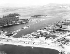
![[Aerial view of the piers on the waterfront of] Vancouver, B.C.](/uploads/r/null/2/0/20aba7c72fbaff48163c905a081b26e279ffb5c8bb90db511f18e1662152abb5/aeaa6a64-f52b-4521-a874-dcce97de484f-A43206_142.jpg)
[Aerial view of the piers on the waterfront of] Vancouver, B.C.
![[View looking east from Main Street and Pender Street]](/uploads/r/null/8/0/809cf6a26840094bf6d8fe3ddd67086496a879a0bb94d26685982dda7e6f42a7/0bafdc9e-9e34-4fc8-9e04-8b7bcfd96944-A43299_142.jpg)
[View looking east from Main Street and Pender Street]
![Vancouver, B.C. [from the air looking east from Lost Lagoon]](/uploads/r/null/5/1/5127fcacb95395f95ba7c0f104a40a408b7f3d76e10c9881ebcc71cfc1a7c5de/ee54b68d-1f24-417f-b491-0956e3d4522f-A42965_142.jpg)
Vancouver, B.C. [from the air looking east from Lost Lagoon]

Vancouver, B.C.
![[Aerial view showing the northwestern section of Downtown]](/uploads/r/null/d/a/da84098b0ef036990e34132f726d1491bbbb1fc247cc76fc6659886372017fdc/a8601693-c900-4d47-a380-9979b203400b-A43287_142.jpg)
[Aerial view showing the northwestern section of Downtown]
![[Aerial view looking northwest over Downtown]](/uploads/r/null/b/7/b7ca69254d2cbe14ffd3cb21ed6f3b1fed68dde7a4a5843876f8c173674d9d01/a1129a0c-5269-4488-9376-66246af93f6d-A43286_142.jpg)
[Aerial view looking northwest over Downtown]

Georgia Street Vancouver, B.C.
Vancouver B.C. Looking North

[Model of civic auditorium superimposed onto an aerial view of the proposed building site between Howe, Hornby, Robson and Smithe Streets]

Prince George, British Columbia
![[Aerial view looking east of downtown Vancouver and the waterfront]](/uploads/r/null/a/1/a146c28159c45997dd3312d8a94967907da12e5b5c1139902f95665ab0e54675/740905a3-6e61-4ffc-bc08-d90ad82bc7d8-A67011_142.jpg)
[Aerial view looking east of downtown Vancouver and the waterfront]
![[H.M.C.S. "Vancouver"]](/uploads/r/null/4/0/40d05283991f8a914e2f61116a8aa8fdd34edba558afb1cedac93df18b745017/22fe1139-eab9-4358-ac03-5356b4e12a8a-A67012_142.jpg)
[H.M.C.S. "Vancouver"]
![[Aerial view of Vancouver and Burnaby]](/uploads/r/null/f/b/fbdba44a19d2b4928094d872a6a16513550380c67160420213fe19581531e9c6/bb3aa326-0dd0-4dbe-879c-2a4a1527d49f-A66597_142.jpg)
[Aerial view of Vancouver and Burnaby]
![[Aerial view of Mount Pleasant, South Strathcona and Kensington-Cedar Cottage]](/uploads/r/null/7/5/75ea991fe8319eaffda79b314cbf20e281e35eb2cd8a89eaa898b492242d6282/05f856f3-0a45-41eb-94dc-46cb9d2f7ecf-A63348_142.jpg)
[Aerial view of Mount Pleasant, South Strathcona and Kensington-Cedar Cottage]
![[Aerial view of Vancouver]](/uploads/r/null/b/9/b973b9a4143a5316b02e728c35d99e383f27a3db21d8e20aa7bbb459780243bc/3ff38b56-6b36-4c17-bce1-329c97459d29-A66598_142.jpg)
[Aerial view of Vancouver]
![[Aerial view of West Point Grey, Kitsilano, Dunbar - Southlands and University Endowment Lands]](/uploads/r/null/0/8/089d213e9a81ca689130a244122a86972e068c9b01ab994922a88072ac881121/1ed71859-c157-4686-82db-e3483cd4b877-A66599_142.jpg)
[Aerial view of West Point Grey, Kitsilano, Dunbar - Southlands and University Endowment Lands]
![[Aerial view of Burrard Inlet, Hastings-Sunrise, Burnaby and the District of North Vancouver]](/uploads/r/null/d/f/df7e11c97173ce0473c454f0a01569b641972f6efdc12bf192edbc42119542d6/6d72f89b-9b55-48c4-bef6-04eb2137f1d3-A66600_142.jpg)
[Aerial view of Burrard Inlet, Hastings-Sunrise, Burnaby and the District of North Vancouver]
![[Aerial view of Burrard Inlet, Vancouver waterfront and North Vancouver waterfront]](/uploads/r/null/7/e/7ebb42bad115eb635562fde51fb418b1e63ecf9048f15193681f167f6966c96a/874ecdbf-b7e9-4561-b45f-1003efcc073f-A66601_142.jpg)
[Aerial view of Burrard Inlet, Vancouver waterfront and North Vancouver waterfront]

[Aerial view of North Vancouver, First Narrows, Stanley Park, West End, Coal Harbour, Burrard Inlet, Vancouver Waterfront and Downtown]
Aerial photograph of downtown Vancouver, south shore False Creek, North and West Vancouver
Aerial photograph of downtown Vancouver, south shore False Creek, North and West Vancouver
Welcome to Vancouver a complimentary guide to Vancouver international airport and the city
Welcome to Vancouver a complimentary guide to Vancouver international airport and the city
![[Aerial view of the Cleveland Dam and Capilano Lake]](/uploads/r/null/2/d/2dd436651b825b9f47ef30c7faef322e33a7a58fafcada712d5da71134736c7d/af2b6b11-8b8c-4e04-9855-a2c6380c8e6f-A33749_142.jpg)
[Aerial view of the Cleveland Dam and Capilano Lake]
![[Aerial view of the Cleveland Dam, Capilano Lake and a portion of the Glenmore subdivision]](/uploads/r/null/3/9/399b03da5e7aff8921c363411aff0ff59308b840b0fcf3d1f9e45e54612a6398/241ed6bf-dc7b-4f29-930e-542982da6184-A33748_142.jpg)
[Aerial view of the Cleveland Dam, Capilano Lake and a portion of the Glenmore subdivision]
![[Aerial view of Ripple Rock prior to blasting in the Seymour Narrows ]](/uploads/r/null/2/a/2a502b9f749a5237c71cd2eebffdb5d9cf761c2fe79592e06d90aa7d2fdcb122/d8917a3e-684b-4ed5-aff6-4c4fee905c19-A33747_142.jpg)
[Aerial view of Ripple Rock prior to blasting in the Seymour Narrows ]

Quesnel, B.C.
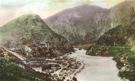
In The Fraser Canyon at Yale, B.C.

Cape Mudge Lighthouse from the Air
![[Aerial view of a Trans-Canada flight over the Legislature Buildings]](/uploads/r/null/2/c/2c11ee8d03efbcf7ecadfbef3e61bc88240bece54cf13185b1a31de5f44ee0e8/554c34a1-7b7a-4613-bfd4-d5e38c3aa6a1-A33475_142.jpg)
[Aerial view of a Trans-Canada flight over the Legislature Buildings]
![[Aerial view of Vancouver showing West and North Vancouver in the distance]](/uploads/r/null/8/d/8d777f00e47e79c44a6ac156af179a087158c26ea0c533480d2a2fb614a2f72e/3d4beb27-2bde-4b39-9fa9-51ad4fca5418-A37529_142.jpg)
[Aerial view of Vancouver showing West and North Vancouver in the distance]
![[Aerial view of Tofino]](/uploads/r/null/8/1/81c09684e8d4571f12e01787f91c039df91a24e8aacac39932ebe70471e03f55/cc49f384-8d43-44c3-b3d0-d7684a374215-A33420_142.jpg)
[Aerial view of Tofino]
![[Aerial view of Ucluelet]](/uploads/r/null/c/8/c8cece718ec98f75d48c6cdd551d9b6e231b87f8401a1d00040d893672754082/ea50645d-b743-42fa-bd2b-e85f95662230-A33419_142.jpg)
[Aerial view of Ucluelet]
![[View of the Swift Canadian Company Limited property and buildings]](/uploads/r/null/a/9/a94fbd27681be80f3d9a714c4b8dbb6eddae9d0e900935f390887b0579aeafa2/b0dd9a53-265d-4196-8cb8-b16a0bbbafc5-A33287_142.jpg)
[View of the Swift Canadian Company Limited property and buildings]
![[View of Pasley Island in Howe Sound]](/uploads/r/null/5/6/56ccb0c9a28a04d8d9eea97ed1f83c3199ad3a9e83a6a6f772a9d888668dbd89/f4a51183-b104-4fdf-984e-4486f9cc57a1-A33259_142.jpg)
[View of Pasley Island in Howe Sound]
![[The Malibu Club from the air]](/uploads/r/null/8/4/84af9ce4b59a192b718b53f0cc73247ecb96e71fc39ca29a306561109eae9386/f24d271e-7bc5-4c99-871b-b40a888223ac-A33224_142.jpg)
[The Malibu Club from the air]