!["Lost Mine" - Lots Of Sparkle? - [camera rolls] 1-3](/uploads/r/null/1/2/1228427/87f57fea-95b8-42f9-888b-5b77a1ba730b-MI-315_142.jpg)
"Lost Mine" - Lots Of Sparkle? - [camera rolls] 1-3

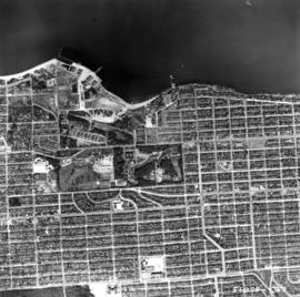
Aerial photo, vertical, False Creek, Fairview to Kits Point

Aerial photo, vertical, University of British Columbia and University Endowment Lands

Aerial photo, vertical, Little Mountain and Oakridge and surrounding area

Aerial photo, oblique, downtown Vancouver to North Shore Mountains

Aerial view of Little Mountain area
![[Aerial view of] British Pacific Properties [and North Vancouver]](/uploads/r/null/1/4/14644a75d43dd6a85d7a3c082e63134f4994ac268e97d1c0940f786b344bbd7e/46041e12-d683-4b08-81b0-797947030f8f-A23485_142.jpg)
[Aerial view of] British Pacific Properties [and North Vancouver]
![[Aerial view of Gibson's from 1000 feet]](/uploads/r/null/d/5/d58c7a9e607bc9f48df5886422ab0aba4830b659d95dc8901154f7dd62e737dd/5636f7ef-5742-455c-8626-5939b6fe11c5-A23483_142.jpg)
[Aerial view of Gibson's from 1000 feet]
![Vancouver looking east from [Howe Sound]](/uploads/r/null/6/6/66fa4a6e8bb1ab5d20d8f951fa93ad57dd828be645aff6d182d88a8b36c69281/69bee6e1-54a6-4c8f-a7db-043e03b4dfe6-A23503_142.jpg)
Vancouver looking east from [Howe Sound]
![[Aerial view looking north over] Granville Island](/uploads/r/null/8/3/83f9be0a597100103c181fa4d68c68baa4a0802471126afafea3b7850103e12b/ea9e7fb6-7465-4fa6-8fa9-18923e3d9307-A49646_142.jpg)
[Aerial view looking north over] Granville Island

Aerial photo, oblique, 41st Ave. and Oak St., Vancouver
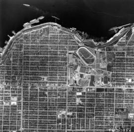
Aerial photo, vertical, Exhibition Park and surrounding area

Aerial photo, vertical, Marpole and junction of Fraser River, Bridgeport

Aerial photo, vertical, Deadman's Island, Coal Harbour and surrounding area

Aerial photo, oblique, CPR docks in foreground, looking south Granville Street at centre
Aerial photo, vertical, Jericho Beach Park and Kitsilano

Aerial photo, vertical, Iona Island and Fraser River
![[Aerial map of Greater Vancouver]](/uploads/r/null/5/6/0/560c4a977bf4bd23ded38e3e8d0c471a86a303d135869c5e459d1977eeed33a6/f660f804-da91-422b-9622-82ae60a89bbe-MAP358_142.jpg)
[Aerial map of Greater Vancouver]

A.C.T. Stock Farm

Aerial view of Brockton Point in Stanley Park looking south
![[Aerial survey photograph with river]](/uploads/r/null/f/e/fe98d2abefe97f551eec30eb0326bbb273e1ee059396e9f6909ffc1984a9f7ea/6786642e-fcc8-4f00-bf6d-26d122fae5ec-A38258_142.jpg)
[Aerial survey photograph with river]
Aerial of Vancouver, B.C. [over False Creek]
Aerial of Vancouver, B.C. [over False Creek]
Aerial shot from over Stanley Park
Aerial shot from over Stanley Park
Summer 1982 - Aerial shot from the south side of False Creek before Expo
Summer 1982 - Aerial shot from the south side of False Creek before Expo
Aerial shot of the West End from over English Bay with Denman Street meeting Beach Avenue near the Old Boat House
Aerial shot of the West End from over English Bay with Denman Street meeting Beach Avenue near the Old Boat House
Aerial of Vancouver, B.C.
Aerial of Vancouver, B.C.
![[Aerial view of the construction of the Deas (Massey) Tunnel]](/uploads/r/null/4/2/427b9c1a187745eb075c78ac228437392381ab4f50b1f4bf255c66efea55880d/5f92abf3-38c1-4c3a-9916-22338f6c99a5-A61247_142.jpg)
[Aerial view of the construction of the Deas (Massey) Tunnel]
![[Aerial view of the recently opened Deas (Massey) Tunnel]](/uploads/r/null/d/7/d7559c73b661cc7e8ed085c039d748d59692a531dd45579060162608c8118845/35561741-5971-4f8d-ad2e-bf938eef38b9-A61246_142.jpg)
[Aerial view of the recently opened Deas (Massey) Tunnel]
![[Aerial view of City of Vancouver, image of printed photograph]](/uploads/r/null/a/6/5/a6568a4fca40576b2d2b079a13541a80ace37c89086c2a64db6237dfdb087262/fb145724-094b-4d2e-9a60-24df3aef9c61-CVA1095-06997_142.jpg)
[Aerial view of City of Vancouver, image of printed photograph]
![[Aerial view of City of Vancouver, image of printed photograph]](/uploads/r/null/3/b/6/3b6df85f34e645db70d12e261cd1a8c0cea08edc95e2716ce32a92dc881a5878/efd40a47-faf5-435c-8b80-2f9099c88723-CVA1095-06996_142.jpg)
[Aerial view of City of Vancouver, image of printed photograph]
![[Aerial view of City of Vancouver, image of printed photograph]](/uploads/r/null/f/3/2/f3234fb45e4f46831886bd2cb6694f50a56ee898e4f2bd5b62dac4912067f52e/e5d60571-6952-41a6-8a5f-aba132b36f28-CVA1095-06995_142.jpg)
[Aerial view of City of Vancouver, image of printed photograph]
![[Aerial view of City of Vancouver, image of printed photograph]](/uploads/r/null/7/0/d/70d11e62ad0119a7483a61fe5f3229fcc4e1aacd651e6722db2466c5a80a8dcb/35b64a80-d60d-4551-89eb-87a5b81ac347-CVA1095-06994_142.jpg)
[Aerial view of City of Vancouver, image of printed photograph]
![[Aerial view of City of Vancouver, image of printed photograph]](/uploads/r/null/8/0/3/80337fd039988f10176eb1c593eb6cacff2aceac861957b1ea4b7be13e8b5ce7/1bdf7acc-f42b-4f15-bd32-4d7c837f7829-CVA1095-06993_142.jpg)
[Aerial view of City of Vancouver, image of printed photograph]
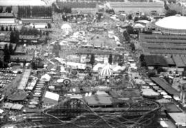
Aerial view of P.N.E. grounds

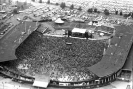
Aerial view of crowd at outdoor concert in Empire Stadium
Aerial photographs of P.N.E. grounds and crowd at outdoor concert in Empire Stadium

Aerial view of crowd at outdoor concert in Empire Stadium
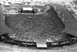
Aerial view of crowd at outdoor concert in Empire Stadium

Aerial view of crowd at outdoor concert in Empire Stadium
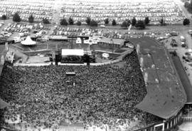
Aerial view of crowd at outdoor concert in Empire Stadium

Aerial view of crowd at outdoor concert in Empire Stadium

Aerial view of crowd at outdoor concert in Empire Stadium

Aerial view of crowd at outdoor concert in Empire Stadium
Aerial view of crowd at outdoor concert in Empire Stadium

Aerial view of crowd at outdoor concert in Empire Stadium

Aerial view of crowd at outdoor concert in Empire Stadium

Aerial view of crowd at outdoor concert in Empire Stadium

Aerial view of crowd at outdoor concert in Empire Stadium

Aerial view of crowd at outdoor concert in Empire Stadium

Aerial view of crowd at outdoor concert in Empire Stadium