Aerial view of Downtown Vancouver, West End and Yaletown, with Granville Street Bridge and Burrard Street Bridge, and C.P.R. [Canadian Pacific Railway] train yards
Aerial view of Vancouver City Hall and residential housing, facing east, on Cambie Street
Aerial view of Mount Pleasant, False Creek, at Main Street and Terminal Avenue, with Canadian Central Station, Opsal Steel, Murrin Substation and Georgia Viaduct
Aerial view of False Creek, facing Mount Pleasant and Fairview, with Cambie Street Bridge, Vancouver General Hospital, Vancouver City Hall
Close aerial view of Vancouver City Hall, with Cambie Street and cars
Aerial view of Downtown Vancouver with Stanley Park, North Vancouver, West Vancouver, North Shore mountains and Burrard, Granville and Cambie Street bridges
Aerial view of False Creek at 2nd Avenue with Cambie Street Bridge and Canadian Western Cooperage sawmill
Aerial view of False Creek at Stamp's Landing with Cambie Street Bridge and Heather Civic Marina and Yaletown Marina
Aerial view of Downtown Vancouver and False Creek, with Fairview, Stanley Park, Cambie Street Bridge, North Vancouver, Lions Gate Bridge, and law courts under construction
Aerial view of Downtown Vancouver and False Creek, between Burrard Street and Granville Street Bridge, with train bridge and Granville Island
Aerial pix of various landfill [1 of 2]
Garbage landfill - Old pictures [13 of 31]
Garbage landfill - Old pictures [14 of 31]
Garbage landfill - Old pictures [15 of 31]
Garbage landfill - Old pictures [16 of 31]
Garbage landfill - Old pictures [17 of 31]
Garbage landfill - Old pictures [29 of 31]
False Creek Construction and Development [31 of 46]
False Creek Construction and Development [32 of 46]
[Aerial survey photograph]
[Aerial survey photograph with river]
[Aerial view of] downtown bounded by Burrard Street, West Georgia Street, Granville Street and Smithe Street]
Aerial view of P.N.E. Gayway at night
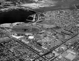
Aerial view of P.N.E. grounds and surrounding area looking northeast
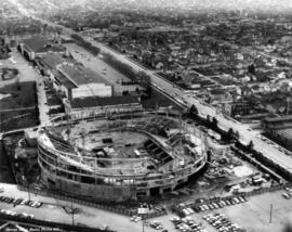
Aerial view of partially completed construction of Pacific Coliseum
Aerial view of partially completed construction of Pacific Coliseum
Aerial view of area surrounding Pacific Coliseum construction looking northeast
Aerial view of area surrounding Pacific Coliseum construction looking east
Aerial view of area surrounding Pacific Coliseum construction looking north
Aerial view of area surrounding Pacific Coliseum construction looking southeast
Aerial view of area surrounding Pacific Coliseum construction looking east
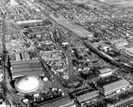
Aerial view of P.N.E. grounds looking southeast
Aerial view of area surrounding Pacific Coliseum construction looking east
Aerial view of area surrounding Pacific Coliseum construction looking northeast
Aerial view of area surrounding Pacific Coliseum construction looking northeast
Aerial view of partially completed construction of Pacific Coliseum
Aerial view of partially completed construction of Pacific Coliseum
Unidentified man and women seated next to aerial photograph of P.N.E. grounds
View of P.N.E. grounds from top of Space Tower
View from top of Space Tower in P.N.E. Playland
Aerial photograph of P.N.E. grounds and surrounding area looking east, including Second Narrows Bridge, Hastings St., and Burnaby Mountain
Aerial photograph of P.N.E. Playland
Aerial view of P.N.E. grounds
Aerial view of east half P.N.E. grounds looking south
Aerial view of P.N.E. grounds and surrounding area looking north
Aerial views of P.N.E. grounds
Aerial view of P.N.E. grounds
Aerial view of P.N.E. grounds and surrounding area looking east
Aerial view of P.N.E. grounds and surrounding area looking northeast


![Aerial pix of various landfill [1 of 2]](/uploads/r/null/4/b/4b64f19cdf8c8c258da84bd571f35c13db694387c6a0eda63ffe8975f1c34a7a/aaf98564-d3f5-4bd4-a4d5-3269ac147dcc-A66347_142.jpg)
![Garbage landfill - Old pictures [13 of 31]](/uploads/r/null/9/6/9611a9971bf09c4fa37dddab2fd6cca6f4bb4ce1339b9078ff4ae26796e4f09a/c54820a5-e089-4481-a805-6c5d594c5f18-A66349_142.jpg)
![Garbage landfill - Old pictures [14 of 31]](/uploads/r/null/f/4/f40eeef962d8de76f02f1c133703296d9fb63530c300417ae08c28c5c8833b54/65308e29-ed50-498c-9967-7f6a2595696a-A66350_142.jpg)
![Garbage landfill - Old pictures [15 of 31]](/uploads/r/null/b/f/bf026c4ad6c00d44c4be6cede0e04e2a487501471a0c14c2066b87d3ad8cb618/055d3f5b-3b53-4c73-9d7d-0501d04b2f13-A66351_142.jpg)
![Garbage landfill - Old pictures [16 of 31]](/uploads/r/null/6/d/6d54b09f3f17e444eaaeaf1171430396e92538cc2c5102751b4705dbc06674b4/8c0e78af-2237-44d2-98af-5cd010c3daf8-A66352_142.jpg)
![Garbage landfill - Old pictures [17 of 31]](/uploads/r/null/b/2/b2a7e5c925bb47f2b66d7a6d618eb39ab16deac7440c2240c8ca5cb1250b6485/147092f2-7408-49c2-8992-a3a848b58183-A66353_142.jpg)
![Garbage landfill - Old pictures [29 of 31]](/uploads/r/null/2/3/23d6c22931868695746ed0ab4398d7008ebac87e7bdc25b2e854c1030b03f286/49e042b7-db6e-421b-9fee-49195dc452cb-A66365_142.jpg)
![False Creek Construction and Development [31 of 46]](/uploads/r/null/9/2/9205574976d816ba47d939bda896f3fde94e94c8a0f2481dbf912b7a77c24ce7/d7044b05-18e0-4ec3-b11a-31e6b126a974-A66429_142.jpg)
![False Creek Construction and Development [32 of 46]](/uploads/r/null/4/b/4b603b6bc6cb92815ca616a42462305634b9f84c5c2e1705caf02a83efccb0ba/bd80820d-2172-4bbd-80bf-c64a0fb2a357-A66430_142.jpg)
![[Aerial survey photograph]](/uploads/r/null/f/a/fab195a7fc233deb2d6de7cd7adbb1c17e581561907ad4326ec3e70802b8053e/7186442f-d249-4e5f-9aca-ac698f0376fd-A40953_142.jpg)
![[Aerial survey photograph with river]](/uploads/r/null/f/e/fe98d2abefe97f551eec30eb0326bbb273e1ee059396e9f6909ffc1984a9f7ea/6786642e-fcc8-4f00-bf6d-26d122fae5ec-A38258_142.jpg)
![[Aerial view of] downtown bounded by Burrard Street, West Georgia Street, Granville Street and Sm...](/uploads/r/null/9/1/a/91aa0079c35a13cc3a22b0f7df0fb214970095aab0b5d871e09523e0499e3dac/42b18aee-e75f-4548-9e3a-bf196c0130ce-CVA145-17_142.jpg)