
Aerial view of eastern portion of Vancouver Harbour showing Vancouver Terminal
- AM1376-: CVA 155-1
- Item
- [ca. 1928]
Aerial view of eastern portion of Vancouver Harbour showing Vancouver Terminal

Aerial view looking south towards Vancouver Terminal Company grain elevators and docks

Sea Island airport, aerial photo, south, from biplane
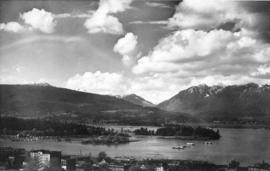
Item is aerial view from downtown Vancouver showing Coal Harbour, Deadman's Island and the North Shore Mountains.

Sea Island airport, aerial photo, northeast

Sea Island airport, aerial photo, northwest

Aerial view of the Convent of the Sacred Heart
Item is a photograph showing an aerial view of Sacred Heart Convent, looking north, bounded by Dunbar Street and U.B.C. Endowment Lands.
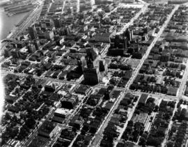
Aerial photo, oblique, downtown Vancouver
Item is a photograph of downtown Vancouver looking northeast. The photo is centred on the Hotel Vancouver and includes the provincial courthouse, surrounding areas, and part of the port of Vancouver.

Aerial photo, vertical, Exhibition Park, Vancouver

Aerial photo, oblique, False Creek, Vancouver
Item is a photograph of False Creek, looking northeast. The photo has (from left to right) the Burrard bridge, the Kitsilano Trestle Bridge, the (old) Granville Street Bridge, and the Cambie Bridge.

Aerial photo, oblique, downtown Vancouver to North Shore Mountains
Item is a photograph of the Vancouver area looking northwest over downtown Vancouver including the Hotel Vancouver, Provincial Courts, the Marine Building, Stanley Park, Burrard Inlet, Lion's Gate Bridge, and Coal Harbour.

Aerial view of Little Mountain area
Item is an aerial photograph showing an oblique view of the Little Mountain area.

Aerial photo, oblique, CPR docks in foreground, looking south Granville Street at centre
Item is a photograph of the Vancouver waterfront, looking southwest down Burrard Street, showing the waterfront and downtown Vancouver, including Waterfront Station, Hotel Vancouver, Marine Building, Burrard Bridge, Granville Street Bridge, and the city beyond.
![[Aerial view looking north over] Granville Island](/uploads/r/null/8/3/83f9be0a597100103c181fa4d68c68baa4a0802471126afafea3b7850103e12b/ea9e7fb6-7465-4fa6-8fa9-18923e3d9307-A49646_142.jpg)
[Aerial view looking north over] Granville Island
Oblique view showing the Granville Bridge and the new Granville Bridge under construction, the Kitsilano Trestle Bridge, of the Burrard Bridge and the industrial and undeveloped areas on the north and south sides of False Creek
![[Aerial photograph of downtown Vancouver looking north]](/uploads/r/null/2/4/24032a0f19bc217e5bb533d7218824f932301e972f1020a352118b50afcf8a93/8e2450db-6794-4283-95a6-7641bc80437d-A69847_142.jpg)
[Aerial photograph of downtown Vancouver looking north]
Photograph shows an oblique view of the north shore of False Creek including the C.P.R. Roundhouse, Yaletown, Cambie Bridge (old), Sweeney Cooperage, Georgia Viaduct, Post Office building under construction, Pier "B/C", Coal Harbour, Stanley Park, Lions Gate Bridge and a view of North and West Vancouver.
Aerial photo, vertical, Jericho Beach Park and Kitsilano
Item is a photograph of Jericho Beach Park and the surrounding area, looking north. The area photographed runs from English Bay and Jericho Beach to W 16th Avenue,and from Sasamat Street to Balaclava Street.

Aerial photo, vertical, False Creek, Fairview to Kits Point
Item is a photograph of False Creek, showing English Bay to W 16th Avenue, and from Maple Street to the Cambie Street Bridge. Includes the Burrard Street Bridge, the new Granville Bridge, the Cambie Bridge, and Granville Island.

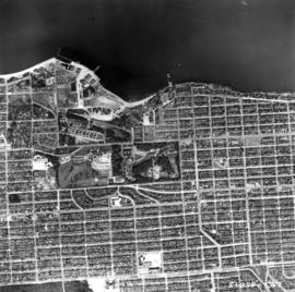
Aerial photo, vertical, Iona Island and Fraser River
Item is a photograph of Iona Island. The area photographed includes the northwest corner of Sea Island and the southwest corner of Southlands. Rafts of lumber are visible.

Aerial photo, vertical, University of British Columbia and University Endowment Lands

Aerial photo, vertical, Marpole and junction of Fraser River, Bridgeport
Item is a photograph of Marpole and northern Richmond, looking north. The area photographed centres on the fork of the Fraser River at Sea Island, and runs from W 67th Avenue to Cambie Rd., and from the western most tip of Richmond Island to the west tip of Mitchell Island. Includes the Marpole Bridge and both Oak Street and Moray bridges under construction.

Aerial photo, vertical, Little Mountain and Oakridge and surrounding area
Item is a photograph of Little Mountain and Oakridge, showing from W 30th Avenue to W 54th Avenue, and from Hudson Street to Main Street. Includes the Langara golf course and Queen Elizabeth Park.
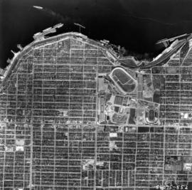
Aerial photo, vertical, Exhibition Park and surrounding area
Item is a photograph of Exhibition Park and the surrounding area, looking north. The area photographed runs from Vancouver Harbour to Charles Street, and from Lakewood Drive to Skeena Street.

Sea Island airport, aerial photo, east

Aerial photo, oblique, 41st Ave. and Oak St., Vancouver
Item is a photograph from Oak and 41st Ave, looking north, with a large partially cleared green area at the bottom of the frame, with downtown, Stanley Park, and the North Shore Mountains in the upper frame.

Aerial photo, vertical, Deadman's Island, Coal Harbour and surrounding area
Item is a photograph of Deadman's Island, including Coal Harbour, and the southwest part of Stanley Park. Compass north is the left side of the photo.
![[Aerial view of fire at Vancouver sawmill]](/uploads/r/null/2/6/261c182ef20aa4aa00d0b46917096bf17c339730ec5975e81a6c1fbc2b63158f/05be5137-bdbf-42ad-a142-3e73d5538015-A71287_142.jpg)
![[R.C.A.F. Maritime Air Command plane No. 102 flying over English Bay]](/uploads/r/null/1/3/13b6c7a118ed10801cfbe633df28806771f06f62a484edbf5de83c5acd20e0a4/ff8af309-b1af-4c30-9216-ba8a2859660d-A71302_142.jpg)
[R.C.A.F. Maritime Air Command plane No. 102 flying over English Bay]
Oblique view showing the Vancouver Maritime Museum and Kits Point residences in the foreground, and the West End, Downtown, Stanley Park and Burrard Inlet in the background.

![[Aerial view of industrial area]](/uploads/r/null/5/d/5dd69372e15c5f349b4b4b8cdb7a12063cbbf02d158ab97d57ba863214b5c209/5f3baa69-a2f9-4adb-a590-4b420086d51d-A71604_142.jpg)
![[Aerial view of Vancouver]](/uploads/r/null/9/b/9b3acec26123edc53f11bf2f41f3286d09254ffea9918cd31b6715395ebe18d0/26473909-fe49-4474-8c3f-05eb1e8ab059-CVA1376-252_142.jpg)
Oblique view showing Fairview, Vancouver General Hospital, False Creek and the Expo 86 and other sites under development on the north side, Granville Island, Granville Bridge, Burrard Bridge, Yaletown, Downtown, the West End, Stanley Park and the Lions Gate Bridge, North Vancouver and The Lions in the background
![[Aerial view of rail yard and industrial area]](/uploads/r/null/9/f/9f92989deb2b54597c6743bd67717653fc644c23b6fc48e55d2e1b9dbf6e8489/763b5a38-9eae-4b16-bedc-45ca5c32d888-A71602_142.jpg)
![[Aerial view of Downtown Vancouver looking south from Burrard Inlet]](/uploads/r/null/3/2/32bc12be65a895f144d669768ee019e6abc83bc4018b11b3ecf96930fbd98786/024e645a-ce5d-4e73-a4e1-efb2ad9b7995-A71518_142.jpg)
[Aerial view of Downtown Vancouver looking south from Burrard Inlet]
Photograph shows Canada Place under construction, the SeaBus terminal, Waterfront Station (formerly the C.P.R. Station), the Marine Building, Harbour Centre and False Creek and Granville Island in the background