
View of City

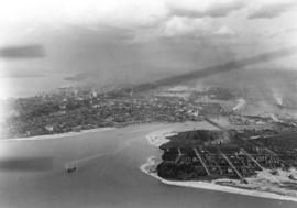
Looking East showing Second Narrows and North Arm of Burrard (South Shore of Inlet - Hastings East)

Looking East Along Georgia Street
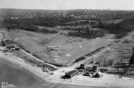
![Race Track - [Hastings] Park](/uploads/r/null/a/e/ae3866984dbd71adb11e4f16a3faeff5c926d7d6dbc7c68bef37bbe9e34f2147/8e72031a-2c43-4d2f-ade2-eaf99cf53105-A44678_142.jpg)
Race Track - [Hastings] Park
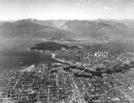
View of Kitsilano and False Creek

Showing Entrance to Stanley Park looking East

Prospect Point Showing West Vancouver Ferry in Narrows
![Grain Elevators and dock - foot of [Commercial] Drive looking east](/uploads/r/null/f/a/fa64fc2fdcd81147912c6227ac42be08f398a362ba801186b73930b6b55d9888/5fb3ff66-892d-4cce-b810-d6918a9c1aed-A44690_142.jpg)
Grain Elevators and dock - foot of [Commercial] Drive looking east
![[View of Vancouver Waterfront showing Union Dock]](/uploads/r/null/c/e/e/cee95cbf9aaa5e1575599f13a63661f6af1be660e92b8121f91e9cf4da242d14/bfb01bf2-4ce4-4ce5-a8d2-6b7244d5e1df-CVA374-146_142.jpg)
[View of Vancouver Waterfront showing Union Dock]
![Aerial view [of Coal Harbour] taken about 1924](/uploads/r/null/b/b/d/bbdc60cbd22ccc304389718ccb2f6a0ca5a1fa849f7ae6fcb7a5e340b38d6240/0f7878e2-d7fb-45db-bcb7-18acde1d4105-CVA66-07_142.jpg)
Aerial view [of Coal Harbour] taken about 1924
![[Aerial view looking east over Stanley Park, Coal Harbour and Burrard Inlet]](/uploads/r/null/d/0/d02fee694c486ac2accdeefb505d0dae5fcb42789ef16de49322d845e3c04b44/be8c34ce-7c09-4c0e-a395-f083c9134080-A43248_142.jpg)
[Aerial view looking east over Stanley Park, Coal Harbour and Burrard Inlet]
![[View of Vancouver waterfront showing Union Dock]](/uploads/r/null/d/d/7/dd7ab36410c42b9534434120e65592352742facf102963e83e7d56a08e4dd00e/88ad4685-0b94-4bb5-801e-318dd133e0f9-CVA374-145_142.jpg)
[View of Vancouver waterfront showing Union Dock]
![[Aerial view looking north over Downtown]](/uploads/r/null/4/b/4b54e616319b32d55e40e5c7404b5eccbd9b053f144a101245a1e709d1cfd4d2/1752a263-31cd-4155-880a-ead0fa54c115-A43250_142.jpg)
[Aerial view looking north over Downtown]
![[Aerial view looking north from False Creek]](/uploads/r/null/0/8/081746026b1559c2ace13027d77c668cba79e15800d0ca6ca466b205529e45b3/ce072490-3b01-4b65-8d61-bfaa102cca83-A43247_142.jpg)
[Aerial view looking north from False Creek]
![[Aerial view looking east towards the Second Narrows (Iron Workers Memorial) Bridge]](/uploads/r/null/a/3/a30e769b11d82234857ac24837baf510f2440359b92782f8e65bf107d5c50ffe/d0897c6d-49e8-4e61-b76c-6f04433a9e5b-A43252_142.jpg)
[Aerial view looking east towards the Second Narrows (Iron Workers Memorial) Bridge]
![[Aerial view of West End and Stanley Park]](/uploads/r/null/4/d/4/4d4e724e2a486490856fe60b67dfeee43429a3860f0dd9901058a9e86f640a07/120e79a6-7374-40bd-b57b-8eaac78f191c-CVA374-180_142.jpg)
[Aerial view of West End and Stanley Park]
![[Aerial view looking northwest of the West End and Stanley Park]](/uploads/r/null/8/8/7/887dd5ff7e349fb28124477bf87837887e09eb02be29444c2ab484fb9068ab51/a90b562e-ef47-480e-b13c-5cb26250e139-CVA374-181_142.jpg)
[Aerial view looking northwest of the West End and Stanley Park]
![[Aerial view of the CPR Piers "A", "B", & "C"]](/uploads/r/null/c/c/cc83a61bf28d479ee3b43f6f9f31d016a88270965414162937f15e136455615f/64b8af34-6e81-4bd2-a0e1-5923c6b420ec-A49477_142.jpg)
[Aerial view of the CPR Piers "A", "B", & "C"]

Aerial view of eastern portion of Vancouver Harbour showing Vancouver Terminal

Aerial view looking south towards Vancouver Terminal Company grain elevators and docks
![[Aerial photograph of the third CPR station]](/uploads/r/null/9/3/9363f69f5bfb9481d61b35900379670ba15b8e772331e9caa6991d35c9d56ba4/d6afd168-9017-4907-98a1-0d62f437998c-A49478_142.jpg)
[Aerial photograph of the third CPR station]
![[Aerial view of Kitsilano Beach]](/uploads/r/null/0/4/04933fd0b52b1825a12ac427f70fb35dc469232064c8156168d851093d1ae411/05361ecf-adfc-4cdc-be95-07157d2e9dd1-A23610_142.jpg)
[Aerial view of Kitsilano Beach]

[Aerial view of downtown Vancouver showing showing C.P.R Pier D and Pier B-C looking west to Stanley Park]
![[Aerial view of J.F. Malkin's residence at 1950 Southwest Marine Drive]](/uploads/r/null/e/8/e8b684b06c9e0631c4a425d2b9bcd1376874c91eef26e2a789fe69d080c32f4c/ed047908-3466-488c-9dc3-536dcb876908-A62676_142.jpg)
[Aerial view of J.F. Malkin's residence at 1950 Southwest Marine Drive]
![[Aerial view of Vancouver looking south from Burrard Inlet]](/uploads/r/null/d/1/d168ad5e5af96082c1c6fe04b81895efc9e0f4c037952a04c6f572cc62674f1d/899c29bd-d99f-4ae7-b246-caf98b4806c1-A49667_142.jpg)
[Aerial view of Vancouver looking south from Burrard Inlet]
![[Aerial view of C.P.R. Pier D at foot of Granville Street and part of Pier B-C]](/uploads/r/null/1/2/1279166be0c0e3fb49d7f4d3b69a946f9d333b81011634e471cffa6693a2e4ea/321b8f32-cbb2-4c56-9fea-61c3686ea39c-A49665_142.jpg)
[Aerial view of C.P.R. Pier D at foot of Granville Street and part of Pier B-C]

Aeroplane view of English Bay & the West End of Vancouver, B.C.

Sea Island airport, aerial photo, south, from biplane

Aerial view of swimming pool, Kitsilano Beach, Vancouver, B.C.
Vancouver B.C. Looking North
![[Aerial view of the piers on the waterfront of] Vancouver, B.C.](/uploads/r/null/2/0/20aba7c72fbaff48163c905a081b26e279ffb5c8bb90db511f18e1662152abb5/aeaa6a64-f52b-4521-a874-dcce97de484f-A43206_142.jpg)
[Aerial view of the piers on the waterfront of] Vancouver, B.C.
![[Aerial view of Vancouver showing West and North Vancouver in the distance]](/uploads/r/null/8/d/8d777f00e47e79c44a6ac156af179a087158c26ea0c533480d2a2fb614a2f72e/3d4beb27-2bde-4b39-9fa9-51ad4fca5418-A37529_142.jpg)
[Aerial view of Vancouver showing West and North Vancouver in the distance]
![Vancouver B.C. [from the air looking east from West End]](/uploads/r/null/a/3/a39a59fafd2c470a05e0b8ecba90843c0dcefd64faa8cd1695e25e8515c52ad7/4a63a71b-9508-45ea-b75a-27924fe36db8-A42964_142.jpg)
Vancouver B.C. [from the air looking east from West End]
![[View looking east from Main Street and Pender Street]](/uploads/r/null/8/0/809cf6a26840094bf6d8fe3ddd67086496a879a0bb94d26685982dda7e6f42a7/0bafdc9e-9e34-4fc8-9e04-8b7bcfd96944-A43299_142.jpg)
[View looking east from Main Street and Pender Street]

Vancouver, B.C.
![Vancouver, B.C. [from the air looking east from Lost Lagoon]](/uploads/r/null/5/1/5127fcacb95395f95ba7c0f104a40a408b7f3d76e10c9881ebcc71cfc1a7c5de/ee54b68d-1f24-417f-b491-0956e3d4522f-A42965_142.jpg)
Vancouver, B.C. [from the air looking east from Lost Lagoon]

Georgia Street Vancouver, B.C.
![[Aerial view of] Vancouver, B.C., looking north](/uploads/r/null/c/d/cda493458eca844be4de32241be0c97d6ce49bfc76bdea2aaeeb860d25ad5b91/8938989b-a878-449a-8547-ff5b0fafc0fc-A02558_142.jpg)
[Aerial view of] Vancouver, B.C., looking north
![[Aerial view of Vancouver Harbour looking east from Lost Lagoon]](/uploads/r/null/a/7/a7c598133f7f2c78a6bb65602262bc193ceb787389db5cd31ded3868025265ca/72eb674f-7c20-4ecc-a618-3a1e88e660c8-A62798_142.jpg)
[Aerial view of Vancouver Harbour looking east from Lost Lagoon]

Jericho Golf and Country Club

Looking East Along Spanish Banks
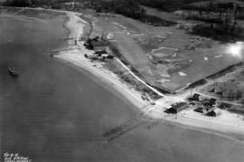
Air Station Development

Aerial view of passenger ship entering the Narrows, Vancouver, B.C.

Looking East Along Spanish Banks
![Vancouver [aerial view of Downtown, Vancouver waterfront and Burrard Inlet looking northeast]](/uploads/r/null/1/7/17c9a12fb86cf85b5f4fd0c94d870a13f459a539954cada4c2e55fc4bf8212ca/9b12d330-c054-4553-bc9e-684e1701d35b-A49464_142.jpg)
Vancouver [aerial view of Downtown, Vancouver waterfront and Burrard Inlet looking northeast]
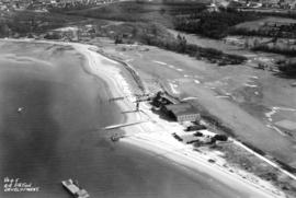
Air Station Development
Air Station Development
![[Aerial view of] Stanley Park Vancouver BC [with] Second Beach Swimming Pool in the foreground.](/uploads/r/null/a/1/a15c959fdf22a475acde3dfbe34911d2ed0e908b82a181e788f415ac76b8aa42/60444948-c365-41d2-8860-876a49aa0885-A23509_142.jpg)
[Aerial view of] Stanley Park Vancouver BC [with] Second Beach Swimming Pool in the foreground.
![[Aerial view of] Vancouver B.C. looking east from English Bay](/uploads/r/null/0/3/03edb95dfe9ca891ff17aa9561a8ca736b17e0997af5e4e0c00c4fbce5babe44/9e1c7ace-8758-4763-a19f-d85080d23dbe-A23510_142.jpg)
[Aerial view of] Vancouver B.C. looking east from English Bay
![Aerial view of Ballantyne Pier [looking south]](/uploads/r/null/4/5/45235bb76932c348ff7b38c5a7aed42364cf041df0b52053089aaaeedf4e1546/a4719fdc-8ecb-403a-9dde-da5cfe6058e1-A23419_142.jpg)
Aerial view of Ballantyne Pier [looking south]