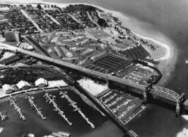
Aerial view of Kitsilano Point, with artist's conception of golf course superimposed on image

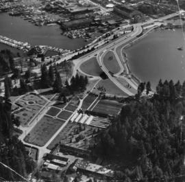
Ferguson Point and Third Beach area

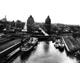
Queen Elizabeth Theatre site

Stanley Park Georgia Street entrance
![False Creek Construction and Development [34 of 46]](/uploads/r/null/3/2/325d3cc7927eb0a37268c415423cae1b41ee0beb2d2552166c7551c14723fbc2/93de867a-2f51-44a7-99d2-74ea424568c4-A66432_142.jpg)
False Creek Construction and Development [34 of 46]
![False Creek Construction and Development [33 of 46]](/uploads/r/null/0/8/0847c9194674abb075e139a51985f8667203c8557e6200c28593021f7e88c9a1/b662d55e-dfa9-41ac-a66c-8c01c50008a5-A66431_142.jpg)
False Creek Construction and Development [33 of 46]
![False Creek Construction and Development [32 of 46]](/uploads/r/null/4/b/4b603b6bc6cb92815ca616a42462305634b9f84c5c2e1705caf02a83efccb0ba/bd80820d-2172-4bbd-80bf-c64a0fb2a357-A66430_142.jpg)
False Creek Construction and Development [32 of 46]
![False Creek Construction and Development [31 of 46]](/uploads/r/null/9/2/9205574976d816ba47d939bda896f3fde94e94c8a0f2481dbf912b7a77c24ce7/d7044b05-18e0-4ec3-b11a-31e6b126a974-A66429_142.jpg)
False Creek Construction and Development [31 of 46]
![False Creek Construction and Development [30 of 46]](/uploads/r/null/6/b/6b031ac9ab7b93832c88468a6bed93e9af88daf76f562ebbfb5528fbd97716b4/be48b00a-284e-40da-9df9-cae43a163b18-A66428_142.jpg)
False Creek Construction and Development [30 of 46]
![False Creek Construction and Development [29 of 46]](/uploads/r/null/d/8/d8b2bf2de1b32f72b54508607b94dcedd7009fd72d3c2f00a53fb77f58f5b764/4fe12044-b7d7-4a83-b3a0-fbe668b49d7d-A66427_142.jpg)
False Creek Construction and Development [29 of 46]
![False Creek Construction and Development [16 of 46]](/uploads/r/null/b/7/b7f25fc0ce57359846902658629950abe6516aa23007aa6d7221379c8ca686f3/62e1a447-9428-4078-8c33-246592c8c97e-A66414_142.jpg)
False Creek Construction and Development [16 of 46]
![Garbage landfill - Old pictures [30 of 31]](/uploads/r/null/4/9/490393469a998dbcedfb345eacc21abf127e329df37475cba50526f6a94f373c/de4767a7-476d-4d35-bdb2-48e2ca8e9c87-A66366_142.jpg)
Garbage landfill - Old pictures [30 of 31]
![Garbage landfill - Old pictures [29 of 31]](/uploads/r/null/2/3/23d6c22931868695746ed0ab4398d7008ebac87e7bdc25b2e854c1030b03f286/49e042b7-db6e-421b-9fee-49195dc452cb-A66365_142.jpg)
Garbage landfill - Old pictures [29 of 31]
![Garbage landfill - Old pictures [28 of 31]](/uploads/r/null/6/2/62463a3d6bc7ab9f4c03f69fc729c0b4ebbe03542fee5175ba4a0eb2f67f1e69/c79babe6-e4d2-4c88-b6a9-dadff10c737a-A66364_142.jpg)
Garbage landfill - Old pictures [28 of 31]
![Garbage landfill - Old pictures [27 of 31]](/uploads/r/null/5/7/57015e8cb40d30c2615184c4bf7e57b93ef971a5037a42e36c4fdd16fac9f423/de5606a8-8718-475f-b5e9-cd2ebb097b44-A66363_142.jpg)
Garbage landfill - Old pictures [27 of 31]
![Garbage landfill - Old pictures [26 of 31]](/uploads/r/null/c/9/c9cd67ddd2828a8f66987e920614a10f36bd85aef5be38411b1db97da911fa76/2fb23205-6d62-45c9-bcdc-c526bbd197e1-A66362_142.jpg)
Garbage landfill - Old pictures [26 of 31]
![Garbage landfill - Old pictures [25 of 31]](/uploads/r/null/5/0/5077507d68c287c6488b7347abb1565f3bf127721e50d4f0116fca5f5804ce29/6cd10d11-0620-4d4a-9c90-4bf58fe354b3-A66361_142.jpg)
Garbage landfill - Old pictures [25 of 31]
![Garbage landfill - Old pictures [24 of 31]](/uploads/r/null/c/c/cc338661ac851aa511fa08074b44d8d303a43627b21e381fc6d750c38baa0b33/af33bbd4-bc4f-425a-b550-6ceffe96e51c-A66360_142.jpg)
Garbage landfill - Old pictures [24 of 31]
![Garbage landfill - Old pictures [23 of 31]](/uploads/r/null/3/2/3268504596e0b7668d8d7b73368411bd0efd26468a9bb6c47bc19f6e5893227a/dfeb33ea-7f30-4c41-ae9e-9ce3cda9d628-A66359_142.jpg)
Garbage landfill - Old pictures [23 of 31]
![Garbage landfill - Old pictures [22 of 31]](/uploads/r/null/1/6/1629ff01fc83ca2f37b4d8155019d21781b81faf842f824ec86a4b63bf59c513/adc7b2b1-1095-485e-8464-6386e49962b5-A66358_142.jpg)
Garbage landfill - Old pictures [22 of 31]
![Garbage landfill - Old pictures [21 of 31]](/uploads/r/null/f/a/fa41af6b3d1952074bbf76248185156be6015a0b34c8305f91d5a33e6d604768/ee42a0f0-0fa7-4904-aee5-0c69b95f162d-A66357_142.jpg)
Garbage landfill - Old pictures [21 of 31]
![Garbage landfill - Old pictures [20 of 31]](/uploads/r/null/7/c/7cc6b2058aa21dddca9e4d4f13e4cfd4ba150bf7c95e5f5cfa2d6f0181a85c43/1dcbef78-c3ae-4895-9b59-ffef580d0d5d-A66356_142.jpg)
Garbage landfill - Old pictures [20 of 31]
![Garbage landfill - Old pictures [19 of 31]](/uploads/r/null/7/3/73a20f15559f5b13ce3bf3c4a62207d63a3768bc34c324024b6dbd6456a746c6/2ef242b7-ba65-4fb3-a10e-b40bc96bdca6-A66355_142.jpg)
Garbage landfill - Old pictures [19 of 31]
![Garbage landfill - Old pictures [18 of 31]](/uploads/r/null/d/0/d040038fed80dd33a6672bf5bc76e322ebf322d702a54c8232f84ad1be4cffa8/5d3d7160-7fd1-4647-a556-72e1814a3292-A66354_142.jpg)
Garbage landfill - Old pictures [18 of 31]
![Garbage landfill - Old pictures [17 of 31]](/uploads/r/null/b/2/b2a7e5c925bb47f2b66d7a6d618eb39ab16deac7440c2240c8ca5cb1250b6485/147092f2-7408-49c2-8992-a3a848b58183-A66353_142.jpg)
Garbage landfill - Old pictures [17 of 31]
![Garbage landfill - Old pictures [16 of 31]](/uploads/r/null/6/d/6d54b09f3f17e444eaaeaf1171430396e92538cc2c5102751b4705dbc06674b4/8c0e78af-2237-44d2-98af-5cd010c3daf8-A66352_142.jpg)
Garbage landfill - Old pictures [16 of 31]
![Garbage landfill - Old pictures [15 of 31]](/uploads/r/null/b/f/bf026c4ad6c00d44c4be6cede0e04e2a487501471a0c14c2066b87d3ad8cb618/055d3f5b-3b53-4c73-9d7d-0501d04b2f13-A66351_142.jpg)
Garbage landfill - Old pictures [15 of 31]
![Garbage landfill - Old pictures [14 of 31]](/uploads/r/null/f/4/f40eeef962d8de76f02f1c133703296d9fb63530c300417ae08c28c5c8833b54/65308e29-ed50-498c-9967-7f6a2595696a-A66350_142.jpg)
Garbage landfill - Old pictures [14 of 31]
![Garbage landfill - Old pictures [13 of 31]](/uploads/r/null/9/6/9611a9971bf09c4fa37dddab2fd6cca6f4bb4ce1339b9078ff4ae26796e4f09a/c54820a5-e089-4481-a805-6c5d594c5f18-A66349_142.jpg)
Garbage landfill - Old pictures [13 of 31]
![Aerial pix of various landfill [2 of 2]](/uploads/r/null/e/7/e7703b220e446009ac90537bc812e9b18d5961bc3bef9af08496b7511b215a5c/b6eff842-b01a-4f53-9052-d169441bc572-A66348_142.jpg)
Aerial pix of various landfill [2 of 2]
![Aerial pix of various landfill [1 of 2]](/uploads/r/null/4/b/4b64f19cdf8c8c258da84bd571f35c13db694387c6a0eda63ffe8975f1c34a7a/aaf98564-d3f5-4bd4-a4d5-3269ac147dcc-A66347_142.jpg)
Aerial pix of various landfill [1 of 2]
![[View looking northeast from north shore of False Creek over Smithe Street]](/uploads/r/null/8/f/6/8f6d7814ac04d1498743ba52bf07caf7e8dd2cf0290eb319665712b1edfdc180/c5c831e7-835b-48ff-8c87-5c157412dc0c-CVA145-2_142.jpg)
[View looking northeast from north shore of False Creek over Smithe Street]
![[Aerial view of] downtown bounded by Burrard Street, West Georgia Street, Granville Street and Sm...](/uploads/r/null/9/1/a/91aa0079c35a13cc3a22b0f7df0fb214970095aab0b5d871e09523e0499e3dac/42b18aee-e75f-4548-9e3a-bf196c0130ce-CVA145-17_142.jpg)
[Aerial view of] downtown bounded by Burrard Street, West Georgia Street, Granville Street and Smithe Street]
![[Aerial view of] old Cambie Bridge, looking north](/uploads/r/null/e/4/e/e4ec2308129a57f09e5cbdc76587997001f8d0ee7827c7457a74581831b64c92/fa92b5dd-9264-42ea-8f50-dcbf02b02d1a-CVA145-16_142.jpg)
[Aerial view of] old Cambie Bridge, looking north
![[Aerial view of Vancouver] sawmill and West Coast Hardwood Ltd, 7th Avenue and Clark Drive](/uploads/r/null/9/0/b/90bb9ab825876d633ac9282b128e51a609b2d9249375b17ac9a5a9466f055f24/44a65d73-fb54-4de9-beaa-497a8bbf79ab-CVA145-15_142.jpg)
[Aerial view of Vancouver] sawmill and West Coast Hardwood Ltd, 7th Avenue and Clark Drive
![[Aerial view of] Victoria Drive and Pandora [Street]](/uploads/r/null/9/5/9/959fb0c9a58d92f88a5ccb6f239e0ee67e102f59511de48f2d825c37983b7e63/e36283e1-1eca-4e4c-b287-c94f2363af28-CVA145-14_142.jpg)
[Aerial view of] Victoria Drive and Pandora [Street]

Project 2, part of area "a" : aerial photograph

Project 2, part of area "a" : aerial photograph
![[Aerial view of City of Vancouver, image of printed photograph]](/uploads/r/null/a/6/5/a6568a4fca40576b2d2b079a13541a80ace37c89086c2a64db6237dfdb087262/fb145724-094b-4d2e-9a60-24df3aef9c61-CVA1095-06997_142.jpg)
[Aerial view of City of Vancouver, image of printed photograph]
![[Aerial view of City of Vancouver, image of printed photograph]](/uploads/r/null/3/b/6/3b6df85f34e645db70d12e261cd1a8c0cea08edc95e2716ce32a92dc881a5878/efd40a47-faf5-435c-8b80-2f9099c88723-CVA1095-06996_142.jpg)
[Aerial view of City of Vancouver, image of printed photograph]
![[Aerial view of City of Vancouver, image of printed photograph]](/uploads/r/null/f/3/2/f3234fb45e4f46831886bd2cb6694f50a56ee898e4f2bd5b62dac4912067f52e/e5d60571-6952-41a6-8a5f-aba132b36f28-CVA1095-06995_142.jpg)
[Aerial view of City of Vancouver, image of printed photograph]
![[Aerial view of City of Vancouver, image of printed photograph]](/uploads/r/null/7/0/d/70d11e62ad0119a7483a61fe5f3229fcc4e1aacd651e6722db2466c5a80a8dcb/35b64a80-d60d-4551-89eb-87a5b81ac347-CVA1095-06994_142.jpg)
[Aerial view of City of Vancouver, image of printed photograph]
![[Aerial view of City of Vancouver, image of printed photograph]](/uploads/r/null/8/0/3/80337fd039988f10176eb1c593eb6cacff2aceac861957b1ea4b7be13e8b5ce7/1bdf7acc-f42b-4f15-bd32-4d7c837f7829-CVA1095-06993_142.jpg)
[Aerial view of City of Vancouver, image of printed photograph]

Aerial view of Pier B, C and A at the foot of Burrard Street

Aerial view of Coal Harbour and Stanley Park

Aerial view of Burrard Street and surrounding area

[Northern aerial view showing False Creek, Downtown, the West End, Burrard Inlet and North Vancouver]

Aerial view of the City of Vancouver, Redevelopment Project No. 1

Aerial view of the downtown core, post office under construction

Aerial view of False Creek


![False Creek Construction and Development [34 of 46]](/uploads/r/null/3/2/325d3cc7927eb0a37268c415423cae1b41ee0beb2d2552166c7551c14723fbc2/93de867a-2f51-44a7-99d2-74ea424568c4-A66432_142.jpg)
![False Creek Construction and Development [33 of 46]](/uploads/r/null/0/8/0847c9194674abb075e139a51985f8667203c8557e6200c28593021f7e88c9a1/b662d55e-dfa9-41ac-a66c-8c01c50008a5-A66431_142.jpg)
![False Creek Construction and Development [32 of 46]](/uploads/r/null/4/b/4b603b6bc6cb92815ca616a42462305634b9f84c5c2e1705caf02a83efccb0ba/bd80820d-2172-4bbd-80bf-c64a0fb2a357-A66430_142.jpg)
![False Creek Construction and Development [31 of 46]](/uploads/r/null/9/2/9205574976d816ba47d939bda896f3fde94e94c8a0f2481dbf912b7a77c24ce7/d7044b05-18e0-4ec3-b11a-31e6b126a974-A66429_142.jpg)
![False Creek Construction and Development [30 of 46]](/uploads/r/null/6/b/6b031ac9ab7b93832c88468a6bed93e9af88daf76f562ebbfb5528fbd97716b4/be48b00a-284e-40da-9df9-cae43a163b18-A66428_142.jpg)
![False Creek Construction and Development [29 of 46]](/uploads/r/null/d/8/d8b2bf2de1b32f72b54508607b94dcedd7009fd72d3c2f00a53fb77f58f5b764/4fe12044-b7d7-4a83-b3a0-fbe668b49d7d-A66427_142.jpg)
![False Creek Construction and Development [16 of 46]](/uploads/r/null/b/7/b7f25fc0ce57359846902658629950abe6516aa23007aa6d7221379c8ca686f3/62e1a447-9428-4078-8c33-246592c8c97e-A66414_142.jpg)
![Garbage landfill - Old pictures [30 of 31]](/uploads/r/null/4/9/490393469a998dbcedfb345eacc21abf127e329df37475cba50526f6a94f373c/de4767a7-476d-4d35-bdb2-48e2ca8e9c87-A66366_142.jpg)
![Garbage landfill - Old pictures [29 of 31]](/uploads/r/null/2/3/23d6c22931868695746ed0ab4398d7008ebac87e7bdc25b2e854c1030b03f286/49e042b7-db6e-421b-9fee-49195dc452cb-A66365_142.jpg)
![Garbage landfill - Old pictures [28 of 31]](/uploads/r/null/6/2/62463a3d6bc7ab9f4c03f69fc729c0b4ebbe03542fee5175ba4a0eb2f67f1e69/c79babe6-e4d2-4c88-b6a9-dadff10c737a-A66364_142.jpg)
![Garbage landfill - Old pictures [27 of 31]](/uploads/r/null/5/7/57015e8cb40d30c2615184c4bf7e57b93ef971a5037a42e36c4fdd16fac9f423/de5606a8-8718-475f-b5e9-cd2ebb097b44-A66363_142.jpg)
![Garbage landfill - Old pictures [26 of 31]](/uploads/r/null/c/9/c9cd67ddd2828a8f66987e920614a10f36bd85aef5be38411b1db97da911fa76/2fb23205-6d62-45c9-bcdc-c526bbd197e1-A66362_142.jpg)
![Garbage landfill - Old pictures [25 of 31]](/uploads/r/null/5/0/5077507d68c287c6488b7347abb1565f3bf127721e50d4f0116fca5f5804ce29/6cd10d11-0620-4d4a-9c90-4bf58fe354b3-A66361_142.jpg)
![Garbage landfill - Old pictures [24 of 31]](/uploads/r/null/c/c/cc338661ac851aa511fa08074b44d8d303a43627b21e381fc6d750c38baa0b33/af33bbd4-bc4f-425a-b550-6ceffe96e51c-A66360_142.jpg)
![Garbage landfill - Old pictures [23 of 31]](/uploads/r/null/3/2/3268504596e0b7668d8d7b73368411bd0efd26468a9bb6c47bc19f6e5893227a/dfeb33ea-7f30-4c41-ae9e-9ce3cda9d628-A66359_142.jpg)
![Garbage landfill - Old pictures [22 of 31]](/uploads/r/null/1/6/1629ff01fc83ca2f37b4d8155019d21781b81faf842f824ec86a4b63bf59c513/adc7b2b1-1095-485e-8464-6386e49962b5-A66358_142.jpg)
![Garbage landfill - Old pictures [21 of 31]](/uploads/r/null/f/a/fa41af6b3d1952074bbf76248185156be6015a0b34c8305f91d5a33e6d604768/ee42a0f0-0fa7-4904-aee5-0c69b95f162d-A66357_142.jpg)
![Garbage landfill - Old pictures [20 of 31]](/uploads/r/null/7/c/7cc6b2058aa21dddca9e4d4f13e4cfd4ba150bf7c95e5f5cfa2d6f0181a85c43/1dcbef78-c3ae-4895-9b59-ffef580d0d5d-A66356_142.jpg)
![Garbage landfill - Old pictures [19 of 31]](/uploads/r/null/7/3/73a20f15559f5b13ce3bf3c4a62207d63a3768bc34c324024b6dbd6456a746c6/2ef242b7-ba65-4fb3-a10e-b40bc96bdca6-A66355_142.jpg)
![Garbage landfill - Old pictures [18 of 31]](/uploads/r/null/d/0/d040038fed80dd33a6672bf5bc76e322ebf322d702a54c8232f84ad1be4cffa8/5d3d7160-7fd1-4647-a556-72e1814a3292-A66354_142.jpg)
![Garbage landfill - Old pictures [17 of 31]](/uploads/r/null/b/2/b2a7e5c925bb47f2b66d7a6d618eb39ab16deac7440c2240c8ca5cb1250b6485/147092f2-7408-49c2-8992-a3a848b58183-A66353_142.jpg)
![Garbage landfill - Old pictures [16 of 31]](/uploads/r/null/6/d/6d54b09f3f17e444eaaeaf1171430396e92538cc2c5102751b4705dbc06674b4/8c0e78af-2237-44d2-98af-5cd010c3daf8-A66352_142.jpg)
![Garbage landfill - Old pictures [15 of 31]](/uploads/r/null/b/f/bf026c4ad6c00d44c4be6cede0e04e2a487501471a0c14c2066b87d3ad8cb618/055d3f5b-3b53-4c73-9d7d-0501d04b2f13-A66351_142.jpg)
![Garbage landfill - Old pictures [14 of 31]](/uploads/r/null/f/4/f40eeef962d8de76f02f1c133703296d9fb63530c300417ae08c28c5c8833b54/65308e29-ed50-498c-9967-7f6a2595696a-A66350_142.jpg)
![Garbage landfill - Old pictures [13 of 31]](/uploads/r/null/9/6/9611a9971bf09c4fa37dddab2fd6cca6f4bb4ce1339b9078ff4ae26796e4f09a/c54820a5-e089-4481-a805-6c5d594c5f18-A66349_142.jpg)
![Aerial pix of various landfill [2 of 2]](/uploads/r/null/e/7/e7703b220e446009ac90537bc812e9b18d5961bc3bef9af08496b7511b215a5c/b6eff842-b01a-4f53-9052-d169441bc572-A66348_142.jpg)
![Aerial pix of various landfill [1 of 2]](/uploads/r/null/4/b/4b64f19cdf8c8c258da84bd571f35c13db694387c6a0eda63ffe8975f1c34a7a/aaf98564-d3f5-4bd4-a4d5-3269ac147dcc-A66347_142.jpg)
![[View looking northeast from north shore of False Creek over Smithe Street]](/uploads/r/null/8/f/6/8f6d7814ac04d1498743ba52bf07caf7e8dd2cf0290eb319665712b1edfdc180/c5c831e7-835b-48ff-8c87-5c157412dc0c-CVA145-2_142.jpg)
![[Aerial view of] downtown bounded by Burrard Street, West Georgia Street, Granville Street and Sm...](/uploads/r/null/9/1/a/91aa0079c35a13cc3a22b0f7df0fb214970095aab0b5d871e09523e0499e3dac/42b18aee-e75f-4548-9e3a-bf196c0130ce-CVA145-17_142.jpg)
![[Aerial view of] old Cambie Bridge, looking north](/uploads/r/null/e/4/e/e4ec2308129a57f09e5cbdc76587997001f8d0ee7827c7457a74581831b64c92/fa92b5dd-9264-42ea-8f50-dcbf02b02d1a-CVA145-16_142.jpg)
![[Aerial view of Vancouver] sawmill and West Coast Hardwood Ltd, 7th Avenue and Clark Drive](/uploads/r/null/9/0/b/90bb9ab825876d633ac9282b128e51a609b2d9249375b17ac9a5a9466f055f24/44a65d73-fb54-4de9-beaa-497a8bbf79ab-CVA145-15_142.jpg)
![[Aerial view of] Victoria Drive and Pandora [Street]](/uploads/r/null/9/5/9/959fb0c9a58d92f88a5ccb6f239e0ee67e102f59511de48f2d825c37983b7e63/e36283e1-1eca-4e4c-b287-c94f2363af28-CVA145-14_142.jpg)


![[Aerial view of City of Vancouver, image of printed photograph]](/uploads/r/null/a/6/5/a6568a4fca40576b2d2b079a13541a80ace37c89086c2a64db6237dfdb087262/fb145724-094b-4d2e-9a60-24df3aef9c61-CVA1095-06997_142.jpg)
![[Aerial view of City of Vancouver, image of printed photograph]](/uploads/r/null/3/b/6/3b6df85f34e645db70d12e261cd1a8c0cea08edc95e2716ce32a92dc881a5878/efd40a47-faf5-435c-8b80-2f9099c88723-CVA1095-06996_142.jpg)
![[Aerial view of City of Vancouver, image of printed photograph]](/uploads/r/null/f/3/2/f3234fb45e4f46831886bd2cb6694f50a56ee898e4f2bd5b62dac4912067f52e/e5d60571-6952-41a6-8a5f-aba132b36f28-CVA1095-06995_142.jpg)
![[Aerial view of City of Vancouver, image of printed photograph]](/uploads/r/null/7/0/d/70d11e62ad0119a7483a61fe5f3229fcc4e1aacd651e6722db2466c5a80a8dcb/35b64a80-d60d-4551-89eb-87a5b81ac347-CVA1095-06994_142.jpg)
![[Aerial view of City of Vancouver, image of printed photograph]](/uploads/r/null/8/0/3/80337fd039988f10176eb1c593eb6cacff2aceac861957b1ea4b7be13e8b5ce7/1bdf7acc-f42b-4f15-bd32-4d7c837f7829-CVA1095-06993_142.jpg)


