
Aerial Photo of Main Dairy Buildings
- AM54-S4-1-M-8-: M-8-3
- Item
- 1938
Part of Major Matthews collection
Oblique view
Aerial Photo of Main Dairy Buildings
Part of Major Matthews collection
Oblique view
![[Aerial view of Vancouver International Airport looking east]](/uploads/r/null/8/3/830fe0f0435315d0f129705f805f17a91e02023eee9f25253133088b34234f40/bca424dc-2bed-4a77-a101-12ccb09e2bd6-A23482_142.jpg)
[Aerial view of Vancouver International Airport looking east]
Part of Major Matthews collection
![[Aerial view of] The New International Air Terminal - Vancouver, Canada](/uploads/r/null/3/2/328313cf8ea4726ce90bea4bf466f27d0ec0bbfd9875d4262ffc84535ae1313d/90186d0f-81aa-4e5f-a5d3-85e4eab88bdf-A23523_142.jpg)
[Aerial view of] The New International Air Terminal - Vancouver, Canada
Part of Major Matthews collection
Oblique view. Photograph shows Canadian Pacific Airlines and Air Canada planes at the terminal.

Part of Major Matthews collection
Oblique view
![[Northern view of ferry dock and vehicles waiting to cross the Fraser River]](/uploads/r/null/1/e/1e4521441f8d8745191ee8b2e13c8ada5c845d60eb8a32a298b53fbb9d49d14a/7b4466d9-3d69-4f09-90fb-2cbba32227ca-A31899_142.jpg)
[Northern view of ferry dock and vehicles waiting to cross the Fraser River]
Part of Major Matthews collection
Oblique view
![[Aerial view of Vancouver International Airport]](/uploads/r/null/4/d/4d4c3bb29cf09f9dee222a934caaae7b2dbf2625ce952d3d1955a7a79a959a3c/2144721b-f773-46c8-aead-c6a97716e5d8-A23481_142.jpg)
[Aerial view of Vancouver International Airport]
Part of Major Matthews collection
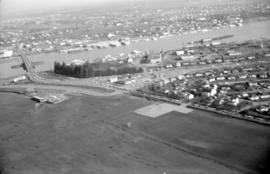
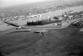
Bridges over Fraser River at Eburne
Part of Stuart Thomson fonds
Oblique view showing the Marpole (Eburne) Low Level Rail Bridge and the Marpole Low Level Highway Bridge from Sea Island and Duck Island
![[Minoru] Park showing track and buildings looking southeast](/uploads/r/null/6/4/648cb80afef74a65543688d3530a5fa0d34e02ce9846a15129939eea7e4998b1/d114b0d7-d9de-4451-bad0-efa589fd7bc4-A44692_142.jpg)
[Minoru] Park showing track and buildings looking southeast
Part of Stuart Thomson fonds
Oblique view

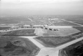
Aerial view of Vancouver airport, Sea Island

Aerial view of Vancouver airport, aircrafts at terminal

Air Canada Viscount airplane and Y5 ramp on tarmac
Aerial view of airport terminal, runways and approaches to Sea Island
Aerial view of airport terminal, runways and approaches to Sea Island
Aerial view of airport terminal, runways and approaches to Sea Island

Aerial view of airport terminal, runways and approaches to Sea Island

Aerial view of airport terminal, runways and approaches to Sea Island

Aerial view of airport terminal, runways and approaches to Sea Island

Aerial view of airport terminal, runways and approaches to Sea Island

Aerial view of airport terminal, runways and approaches to Sea Island
Aerial view of airport terminal, runways and approaches to Sea Island
Aerial view of airport terminal, runways and approaches to Sea Island


![[Aerial view of Vancouver International Airport looking west]](/uploads/r/null/2/7/2/27213688730c7806e46019e512fc12a9c922c9ce4add27fa8b129850ee59a139/40e2c21f-6448-49bd-8d62-0920de53f118-CVA371-2949_142.jpg)
[Aerial view of Vancouver International Airport looking west]
Part of Major Matthews collection
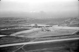
Oblique view showing runways and the buildings at the South Terminal
![[Aerial view of Vancouver International Airport looking south]](/uploads/r/null/4/e/7/4e733739b6b5b5fc2fc34b5e4e03032978086d6ed7b6d3291b6af05020ed4f5d/57dbc7d8-a33c-4f92-98a4-6c9e4d042748-CVA371-2950_142.jpg)
[Aerial view of Vancouver International Airport looking south]
Part of Major Matthews collection
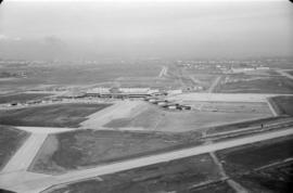
Oblique view showing runways and the terminal buildings
![[Aerial view of shopping centres]](/uploads/r/null/d/2/d21dcc14ced0356484b5666789f851fac68a175214b4718fae1444fec7417944/1f264270-6b68-43e6-be2e-f5b59df5d035-A71605_142.jpg)
![[Aerial view of Richmond Centre mall]](/uploads/r/null/2/e/2ee69f17353dd5eafd9d3c5d8d0ae7f95f74b5669c564c68a4c72ffafb9cda20/e0752fe7-4588-4c42-a25c-ef561bf4ed68-A71603_142.jpg)
[Aerial view of Richmond Centre mall]
Item is a photograph showing the Richmond Centre shopping mall as well as Samuel Brighouse Elementary School and Minoru Park.
![[Aerial view of shopping centres]](/uploads/r/null/1/0/10ff59da2ba368988732f96fd1cd6e8fa091b0be501fa556439f7a93e5f7da6e/ac882c6d-a7cb-45e1-94f7-e89b0f645a16-A71607_142.jpg)

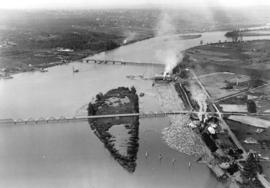
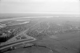
Aerial photo, vertical, Marpole and junction of Fraser River, Bridgeport
Item is a photograph of Marpole and northern Richmond, looking north. The area photographed centres on the fork of the Fraser River at Sea Island, and runs from W 67th Avenue to Cambie Rd., and from the western most tip of Richmond Island to the west tip of Mitchell Island. Includes the Marpole Bridge and both Oak Street and Moray bridges under construction.